Search results from Blog
52 results found for: weiland america
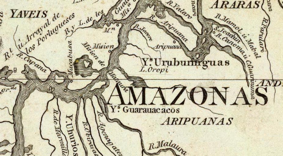
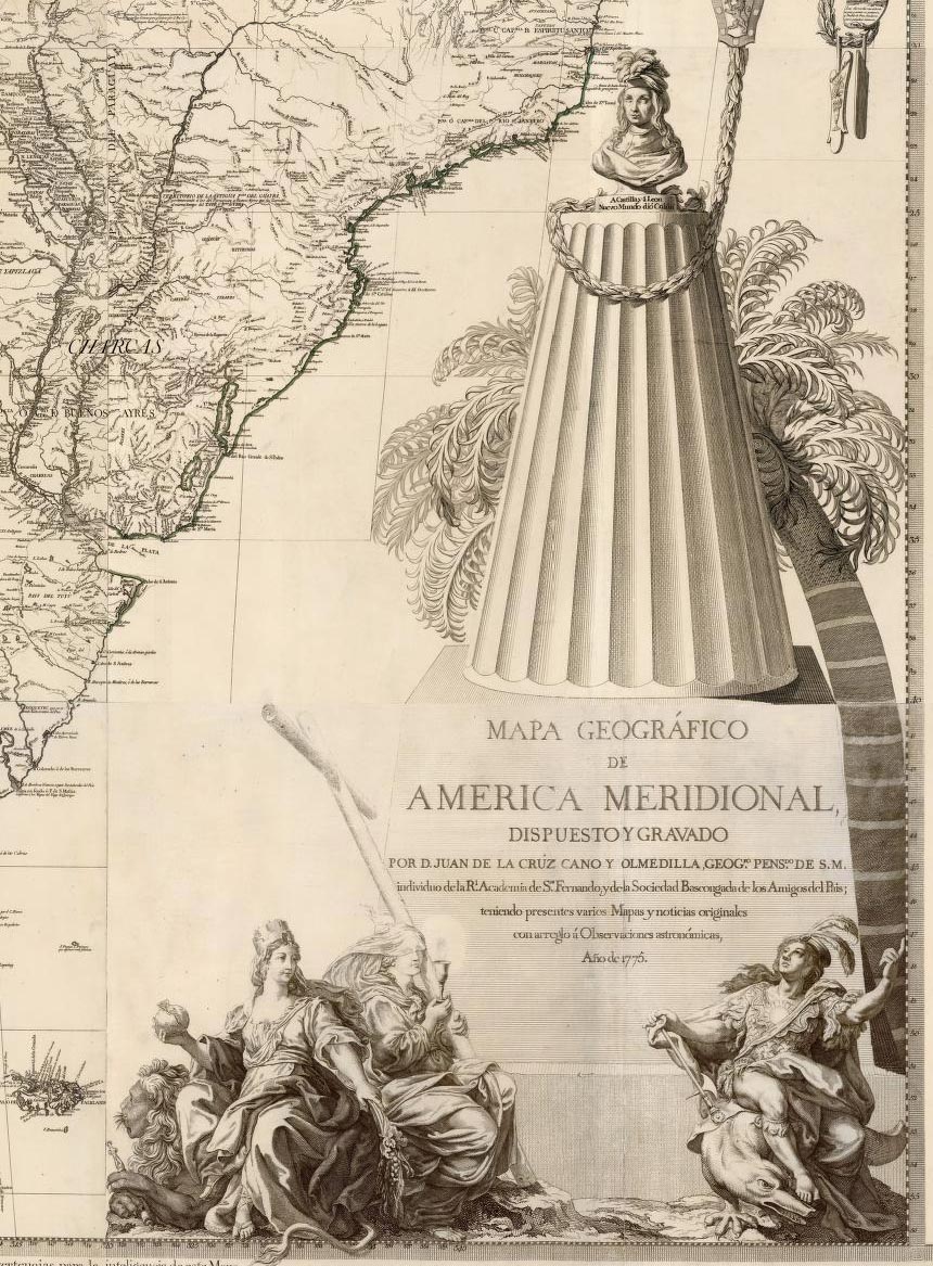
South America 1799
Mapa Geografico de America Meridional, Cruz Cano y Olmedilla, Juan de la, 1799 The upper Amazon River in 1799 was home to countless Indian settlements which are detailed on this Map of South America by William Faden, a London map publisher who in this map republishes the Mapa Geografico de America Meridional of 1775 by the Spanish mapmaker Cruz Cano y Olmedilla. Read full article
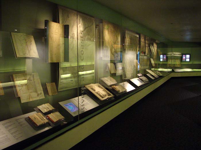
MAPPING AMERICA - Treasures from David Rumsey Historical Map Collection on Display at the San Francisco International Airport June 2003 - January 2004
A selection of over one hundred rare and unique maps from the David Rumsey Historical Map Collection are on display through January 2004 at the San Francisco International Airport. The exhibit explores themes of mapping exploration, settlement, travel, geology, navigation, military campaigns, railroads, and cities. Read an article in Spatial News about the exhibit. A view of part of the exhibit installation along the corridor between Terminals 1 and 2 at the San Francisco Airport. Pictured ... Read full article
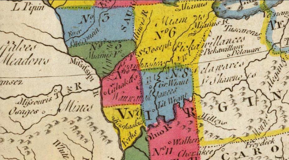
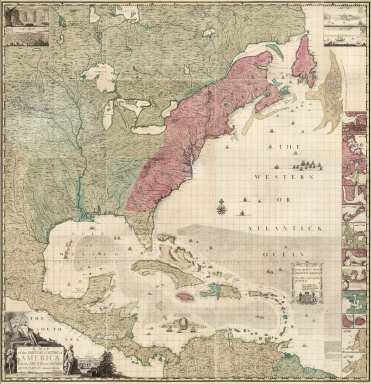
Proposed 11 Territories 1778
A New Map of North America, From the Latest Discoveries, Carver, Jonathan, 1778 In his Map of North America, 1778, Jonathan Carver lays out 11 proposed territories or colonies that never came into existence, but are interesting to see today. Each territories is formed so that it has access to a river, which was the primary mode of transportation at the time. In 1784, Jefferson proposed 14 territories in roughly the same area, which may have been influenced by Carver's plan. Carver's book and... Read full article

Niagara Falls 1823
A Map of North America, Constructed According To The Latest Information, Tanner, Henry S., 1823 This close up view of Niagara Falls comes from the elaborate title cartouche to Henry Tanner Map of North America, 1823, which appears in Tanner's American Atlas of the same year. This scene plus several others in the cartouche make it one of the most beautiful title ornaments of early 19th century American mapping. Read full article
DPLA Announces Partnership with Rumsey Map Collection
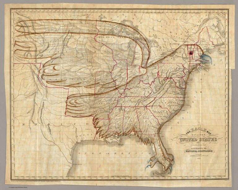
The Digital Public Library of America (DPLA) is partnering with the David Rumsey Map Collection to provide online access to tens of thousands of significant historical maps and images. As part of the relationship, David Rumsey will provide metadata for over 38,000 maps and images (Note: as of 2018, over 82,000 maps and images), making the entirety of his notable online collection instantly accessible via the DPLA website and API. The Eagle Map of the United States. 1833. Joseph and James Chu... Read full article
March 1, 2001 - 1,406 New Maps Added
Highlights from 1,406 New Maps added to the David Rumsey Collection. All titles may be found by searching under Search/by Publication Author using the author names below. Or click here to view all 1,406 new maps. Atlas General, 1771 Monsieur d'Anville 48 maps, including several important maps of the Americas. South America, 1814 Aaron Arrowsmith The huge (over 8 feet tall) six sheet wall map originally issued in 1811. Times Atlas of the World, 1922 John George Bartholomew 117 maps, the secon... Read full article

October 15, 2005 - 1,564 New Maps Added
The following are highlights from 1,564 New Maps added to the David Rumsey Collection. All titles may be found by launching the Insight Browser or Java Client and searching under Search/by Publication Author using the author last names below. Or click here to view all 1,564 new maps. 31 Children's School Atlases ranging in date from 1777 (William Faden, Geographical Exercises, London) to 1875 (Samuel Augustus Mitchell, Ancient Atlas, Philadelphia). Highlights include M.B. Moore, Geographical... Read full article

November 20, 2009 - 1,238 New Maps Added
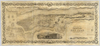
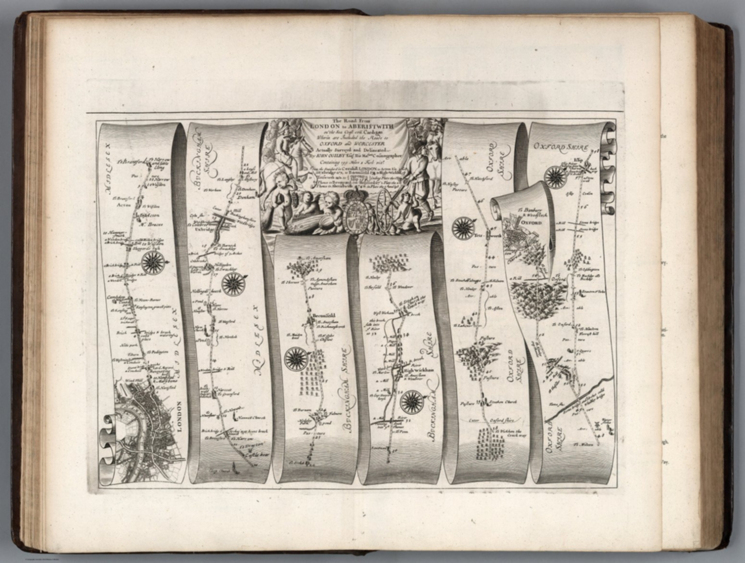
The following are highlights from 1,238 New Maps and Images added to the David Rumsey Collection. Included are John Cary's comprehensive road map of England and Wales from 1794 (plus a composite image joining all 81 sheets), John Wilson's important Map of South Carolina, 1822, Pick's time-line historical chart from 1858, geological and oil maps of Pennsylvania, 2 editions of Rand McNally's Business Atlas, 3 editions of Johnston's Royal Atlas, the atlas edition of Viele's map of New York City ... Read full article

April 12, 2010 - 764 New Maps Added
Below are highlights from 764 new maps and images recently added to the David Rumsey Collection. Included are John Cary's 1790 Survey of the High Roads From London - an early use of strip road maps, the Atlas Classique De La Geographie - an 1839 teaching atlas by C.V. Monin with Monin's version of the classic Mountains and Rivers plate by Bulla, and Rand McNally's monumental 1924 Commercial Atlas Of America, with some of the most detailed early highway maps of the U.S. along with extensive r... Read full article
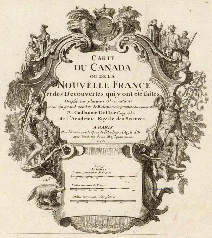
Cartouches, or Decorative Map Titles
Cartouches are the elaborate decorations that frame map titles and other information about the map. They add an artistic or symbolic narrative to the maps they describe. According to map historian Edward Lynam, cartouches that frame titles first appear on Italian maps in the 16th century. They persist on maps until the middle of the 19th century, going through many stylistic changes. Below are selected cartouches from maps in our collection, beginning in 1703 and ending in 1852. The cartouche... Read full article

November 15, 2004 - 1,035 New Maps Added
The following are highlights from 1,035 New Maps added to the David Rumsey Collection. All titles may be found by launching the Insight Browser or Java Client and searching under Search/by Publication Author using the author last names below. Or click here to view all 1,035 new maps. Atlas to Accompany the Official Records of the Union and Confederate Armies, 1895 United States. War Department, Washington, D.C. 182 Maps, views, and plates. Contains reproductions of most of the important maps... Read full article
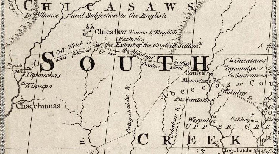
Map of British and French Dominions 1757
Map of the British and French Dominions in North America, Mitchell, John, 1757 This detail of the Chickasaw and Creek Indian lands in present day Mississippi and Alabama shows the kind of interesting notations and use of different lettering that abound on John Mitchell"s Map of the British and French Dominions in North America, 1757. Read full article

December 15, 2001 - 1,012 New Maps Added
Highlights from 1,012 New Maps added to the David Rumsey Collection. All titles may be found by searching under Search/by Publication Author using the author last names below. Or click here to view all 1,012 new maps. Commercial, Topographical, and Statistical Atlas of the United States, 1874 Asher and Adams 41 Maps, most complete edition. This was one of the first United States atlases to exclusively feature railroad lines, showing minimal topography and only showing towns on or next to rai... Read full article
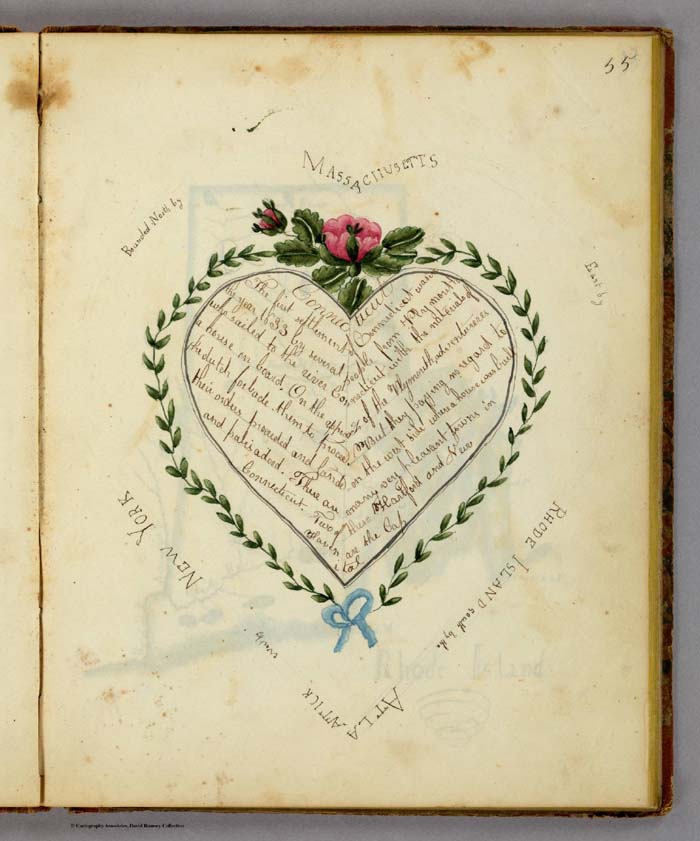
19th Century Maps by Children
In the 18th and 19th centuries, children were taught geography by making their own maps, usually copies of maps available to them in books and atlases at their schools or homes. Below is a group of maps and geographical diagrams made by children in the 19th century; and some of the school atlases, geographies, and wall maps that may have been their sources. These old maps made by children were hand drawn and colored, one-of-a-kind productions, and it is amazing that any have survived down to ... Read full article
November 27, 2010 - 1,786 New Maps Added
Below are descriptions of 1,786 new maps and images recently added to the David Rumsey Collection. Included for the first time are six new BookReaders that enable page turning books in the Luna software; four of these are new atlases: Popple's 1746 Atlas of North America; Pertermann and Milners's 1850 Atlas of Physical Geography; Williamson's 1870 Removal of Blossom Rock in San Francisco Harbor; and Baker's 1936 Atlas of American Agriculture. Also, two important boundary dispute atlases, the ... Read full article

July 1, 2000 - 706 New Maps Added
Highlights from 706 New Maps added to the David Rumsey Collection. All titles may be found by searching under Search/by Publication Author using the author names below. Or click here to view all 706 new maps. London Atlas, 1844 John Arrowsmith 65 maps, including his Map of Texas and 4 important maps of Australia and New Zealand. Complete System of Geography, 1747 Emanuel Bowen 70 maps, including 18 early maps of North and South America and the West Indies. Illustrated Atlas of the United Sta... Read full article
February 11, 2013 - 2,745 New Maps Added
2,745 new maps and images have been added to the David Rumsey Map Collection, bringing the online collection to 37,365 maps and related images. Highlights in this addition are Cruz Cano's large wall map of South America 1775, two miniature atlases from 1758 and 1762, maps by Aaron Arrowsmith, a large group of pocket maps, an important large wall map of Georgia 1818, three copies of Tanner's American Atlas 1823, 1824, 1833, 63 birds-eye views of the Austrian countryside around Vienna 1837, Em... Read full article
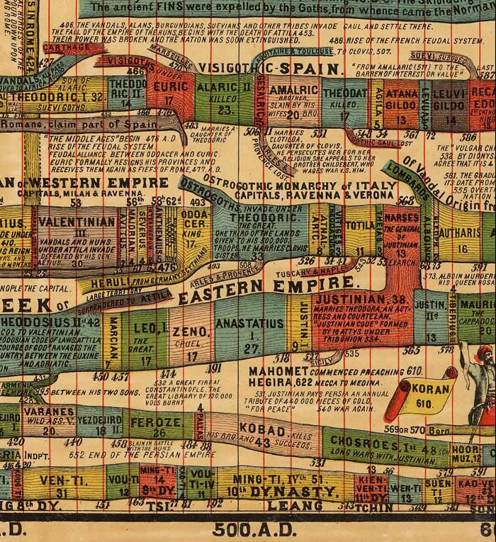
Timeline Maps
Mapping time has long been an interest of cartographers. Visualizing historical events in a timeline or chart or diagram is an effective way to show the rise and fall of empires and states, religious history, and important human and natural occurrences. We have over 100 examples in the Rumsey Map Collection, ranging in date from 1770 to 1967. We highlight a few below. Sebastian Adams' 1881 Synchronological Chart of Universal History is 23 feet long and shows 5,885 years of history, from 4004 ... Read full article
June 24, 2012 - 1,828 New Maps Added
1,828 new maps and images have been added to the David Rumsey Map Collection, bringing the online collection to 32,413 maps and images. Included in this addition are early Yosemite guide books; the Allgemeiner Schulatlas, 1825, a remarkable German school atlas; 216 Maps and Images from Pocket Maps, 1825 - 1920; 12 U.S. County Atlases, 1864 - 1890; The Times Atlas of the World Mid-Century Edition, 1959; Atlas of the United States Printed for the Use of the Blind, 1837; 30 U.S. Civil War maps f... Read full article
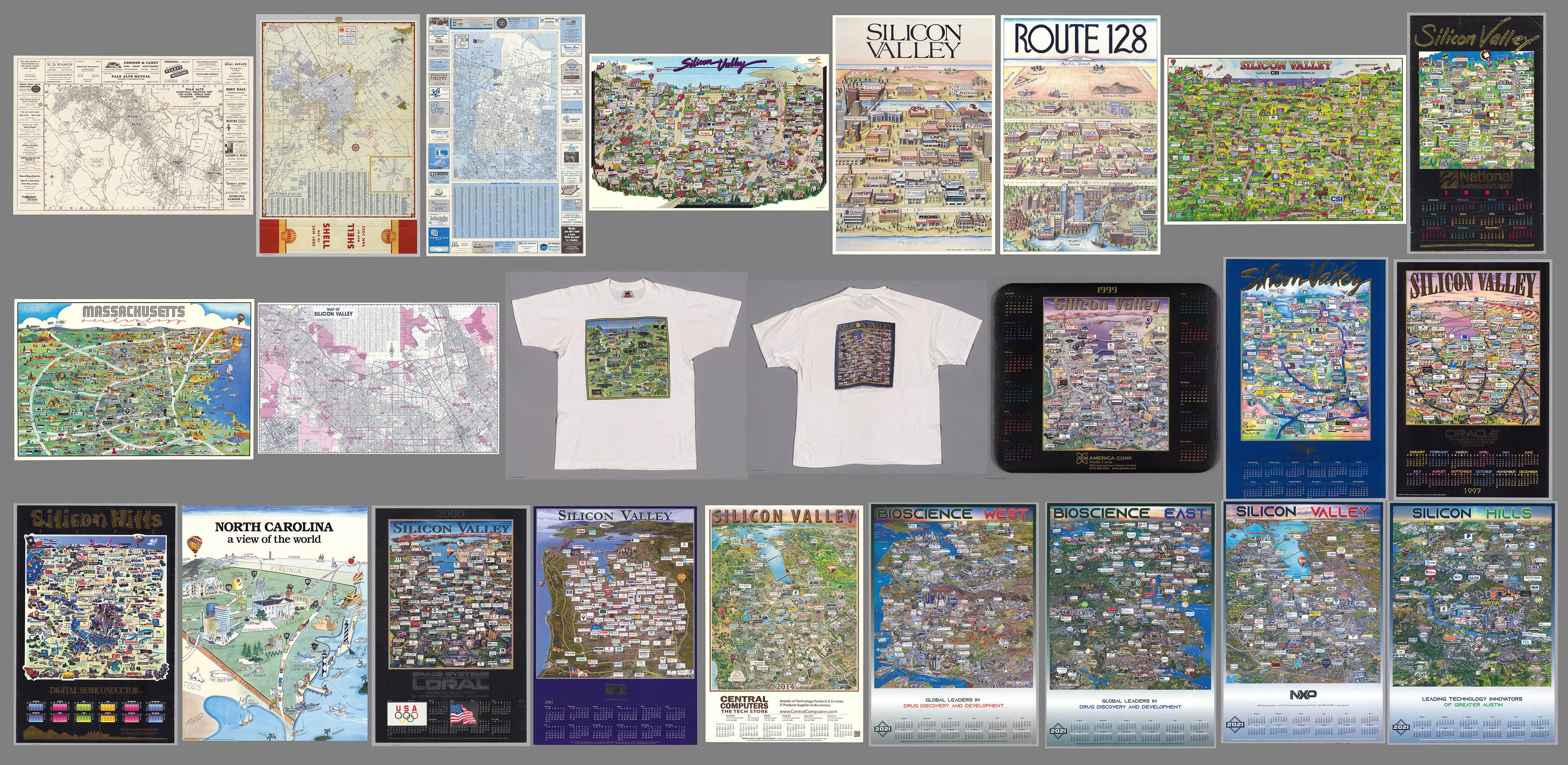
25 Maps of Silicon Valley And Other Tech Hubs
We previously wrote about Early Mapping of Silicon Valley and the Internet. Since then we have added 25 maps of Silicon Valley and other tech hubs like Route 128 in Boston, Austin, Texas, and Chapel Hill, North Carolina. Also we have added some maps of Silicon Valley before it became a tech center. Here is a link to the entire group, including the earlier maps. These maps offer a unique view of the spatial arrangement of Tech firms. While the process of selling advertising spaces on the maps ... Read full article

September 23, 2012 - 2,174 New Maps Added
2,174 new maps and images have been added to the David Rumsey Map Collection, bringing the online collection to 34,595 maps and images. Highlights in this addition are Arrowsmith's Large Maps of Europe, Africa and Asia, 1796 - 1818, Pardies' Star and Constellation Maps of the Heavens, 1693, the five volume 1764 Petit Atlas Maritime by Bellin, Pownall's 1776 Topographical Description, a huge 1845 manuscript map of the New York and New Haven Railroad, a group of Pocket and Guide Maps from 1822... Read full article
March 18, 2011 - 1,634 New Maps Added
1,634 new maps and images have been added to the David Rumsey Map Collection, bringing the online collection to over 26,000 maps and images. Included in this addition are five issues of Colton's General Atlas of the World dated from 1865 to 1886. Also two editions of Schonberg's Standard Atlas of the World, 1865 and 1867. Sheets from two national surveys: six composite images of the entire Wheeler Survey of the U.S. West, 1876, and the first 338 sheets of the massive 19th century survey of G... Read full article
Online Rumsey Maps Reach 105,000. Part Two - 2017 Additions
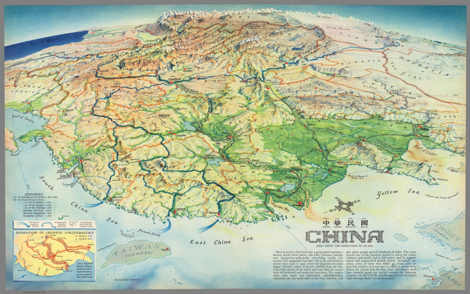
This is Part Two of the blog post documenting the 46,000 new maps and images that have been added online since 2015. The total online collection is now over 105,000. This post covers 50 highlights of additions made in 2017. Later posts will cover the additions made in 2018, 2019, and 2020. All titles may be found by clicking on the View links or images below. China : Chung Hue Min Kuo = central flowery republican country. (Seen from the direction of Guam). Richard Edes Harrison. (inset) M... Read full article
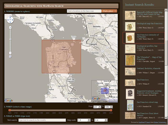
New Geographical Search by MapRank Viewer
The new MapRank Search viewer enables geographical searching of the collection by map location and coverage, in a Google Map window. Pan and zoom the Google Map to the area of the world you want maps of, and the results will automatically appear as a scrollable list of maps with thumbnail images in the right side results window. The maps in the right side results list are ranked by coverage, with the maps that have coverage closest to your search window listed at the top. Maps lower in the li... Read full article

December 14, 2002 - 831 New Maps Added
The following are highlights from 831 New Maps added to the David Rumsey Collection. All titles may be found by launching the Insight Browser or Java Client and searching under Search/by Publication Author using the author last names below. Or click here to view all 831 new maps. United States Of North America, 1808. Arrowsmith, Aaron. A very detailed map of the United States east of the Mississippi River, first published in 1796 and updated in many editions to the mid 1820's. This issue is ... Read full article
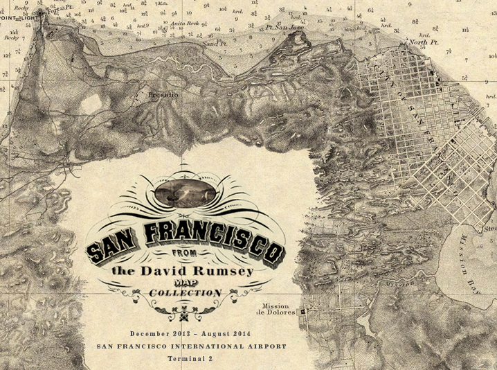
San Francisco Airport Exhibits Maps from Rumsey Collection
Maps of San Francisco from the David Rumsey Collection will be exhibited at the San Francisco International Airport Museum from December 14, 2013 to October 1, 2014. Over 30 maps, views, and photographs document the extraordinary growth of San Francisco from the gold rush village of 1849 to the 20th century metropolis it became. The exhibit will be in the airport exhibition gallery in Terminal 2 (Virgin America and American Airlines), beyond security. The exhibit combines the original maps wi... Read full article
Online Rumsey Maps Reach 100,000. Part One - 2016 Additions
Since the last Recent Additions blog five years ago, more than 41,000 new maps and images have been added online, bringing the total online collection to over 100,000. Because of the large number of maps in this Recent Addition, we are splitting the 41,000 updates into four blog posts of about 10,000 maps each, divided roughly into the years following the last post - 2016, 2017, 2018, and 2019. This post covers highlights of additions made in 2016. All titles may be found by clicking on th... Read full article

August 1, 2008 - 1,038 New Maps Added
The following are highlights from 1,038 New Maps added to the David Rumsey Collection. All titles may be found by clicking on the View links below. Or click here to view all 1,038 new maps. Carte de la France 1790 Cassini, Cesar-Francois, 1714-1784; Capitaine, Louis, ca. 1749-ca. 1797; Cassini family, Paris 5 maps. These maps are a 24 sheet reduction of Cassini's 182 sheet 1750 map, joined together in 4 large sheets of 6 maps each. Includes the key to symbols used in the large Cassini survey.... Read full article

Julius Bien, Master Printer and Cartographer
Julius Bien (1826-1909) was an American lithographic printer and cartographer who worked in New York City in the second half of the 19th century. He was responsible for the publication of thousands of maps issued by the U.S. government and private map publishers. He was a pioneer in the development of chromolithography. He is recognized as one of the finest map printers of his time. The Rumsey collection contains over 1,100 maps published by Bien. Although authorship of 19th century maps a... Read full article

March 21, 2006 - 1,048 New Maps Added
The following are highlights from 1,048 New Maps added to the David Rumsey Collection. All titles may be found by launching the Insight Browser or Java Client and searching under Search/by Publication Author using the author last names below. Or click here to view all 1,048 new maps. Nouvelle Metode, la Geographie, 1693 Dangeau, abbe de, Manuscript French Atlas of outline maps by Dangeau, perhaps some of the earliest examples of outline maps used for teaching geography. View Atlas Introducti... Read full article

June 1, 2003 - 811 New Maps Added
The following are highlights from 811 New Maps added to the David Rumsey Collection. All titles may be found by launching the Insight Browser or Java Client and searching under Search/by Publication Author using the author last names below. Or click here to view all 811 new maps. (Plan of the City of Saint Petersburg), 1753 Akademiia nauk SSSR. 36 Maps and views. This atlas includes a detailed 9 sheet map of Saint Petersburg, shown as 9 separate images plus a composite image of all 9 sheets ... Read full article

March 6, 2009 - 1,572 New Maps Added
The following are highlights from 1,572 New Maps and Images added to the David Rumsey Collection. All titles may be found by clicking on the View links below. Or click here to view all 1,572 new maps. (This link shows 1850 maps and images because some of the new 1,572 items are text pages added to atlases and the entire atlases are shown). Atlas Nouveau, 1742 Covens et Mortier; Lisle, Guillaume de, 1675-172, Amsterdam 107 Maps. The entire text of the bound-in geography has been put online - ... Read full article

July 4, 2010 - 564 New Maps Added
Below are descriptions of 564 new maps and images recently added to the David Rumsey Collection. Included are Jacob Green's Astronomical Recreations, an early U.S. celestial atlas published by Anthony Finley in 1824; Finley's pocket map version of his American Atlas, 1827; the graphically stunning Atlas Elementaire by Soulier and Andriveau-Goujon, published in Paris in 1838; a German atlas version of J. Calvin Smith's important Map of the United States from 1852; an extensive geography text w... Read full article
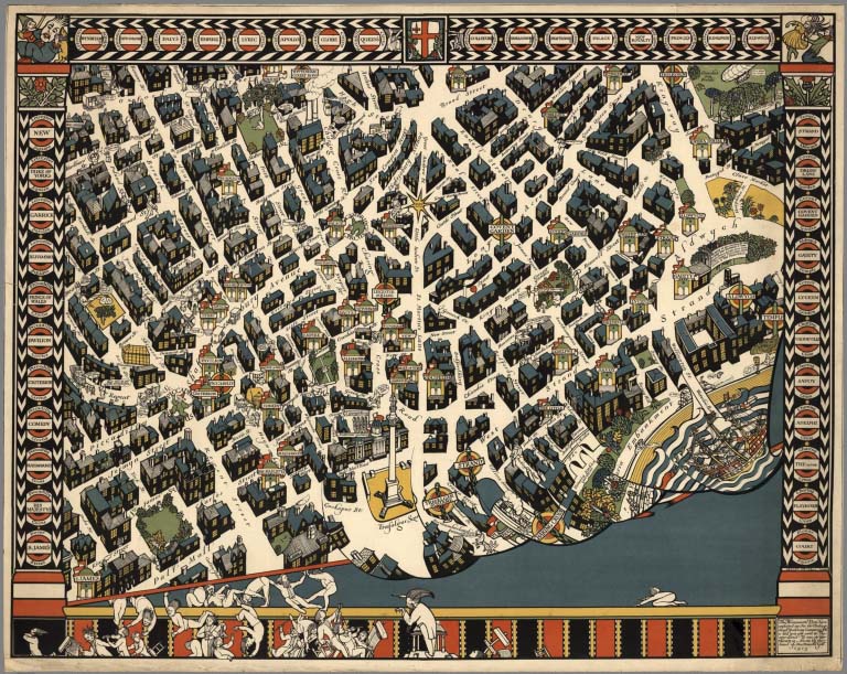
Over 2,000 Pictorial Maps in Online Collection
Over 2,000 Pictorial maps and related images have been added to the David Rumsey Map Collection in the form of separate maps, pocket maps, case maps, atlases, manuscript maps, and wall maps. Pictorial maps are generally described as maps that employ various kinds of illustrations, images, and text that enhance the cartographic message. While they seem to have peaked in popularity in the 1920 to 1940 period, they have antecedents in the 19th and earlier centuries and the form continues today. ... Read full article
March 13, 2012 - 1,596 New Maps Added
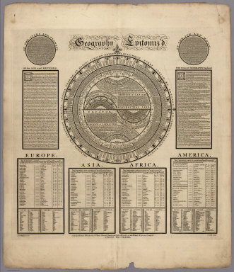
1,596 new maps and images have been added to the David Rumsey Map Collection, bringing the online collection to 30,599 maps and images. Included in this addition is Bowles' 1733 Geography Epitomiz'd, an early example of information visualization; Abraham Bradley's 1805 Post Road Map of the United States; Aaron Arrowsmith's General Atlas of 1817; a group of U.S. Mexican War broadsides and maps; Mitchell's 1855 Universal Atlas; a group of 214 individual maps, charts, broadsides, ephemera, and m... Read full article
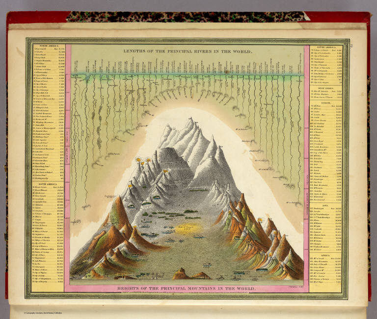
Heights of Mountains, Lengths of Rivers
For over 100 years, atlas and map publishers in the United States and Europe published a style of map that was a visualization of the heights and lengths of the world's mountains and rivers. Some of the earliest examples appeared in Europe towards the end of the 18th century. In the United States, the form was popular throughout the 19th century and the early part of the 20th. These maps appeared in atlases, as wall maps, and as pocket maps. One of the most elegant examples was engraved o... Read full article

Early Mapping of Silicon Valley and the Web
UPDATE: We have added 29 additional maps and related images of Silicon Valley to the Five maps below. Click here to see all 34 Silicon Valley maps. Five pictorial maps below trace the development of Silicon Valley from 1981 to 1991. Six additional maps show the growth of the Web from 1995 to 2009. There are interesting commonalities between the maps, the first group of five showing the physical space of Silicon Valley in the 1980's and the location of its first start up companies, many now go... Read full article
April 4, 2015 - 15,342 New Maps Added
15,342 new maps and images have been added to the David Rumsey Map Collection, bringing the online collection to 58,078 maps and related images. Highlights in this addition are over 2,000 Pictorial Maps; the Claes Janszoon Visscher 1611 Leo Belgicus map; the 1570 and 1608 editions of the Ortelius Theatrum Orbis Terrarum; a massive group of German Invasion plans for England, Wales, and Ireland in WW II; 1682 Map of the areas around Mexico City; 2 important early atlases of Swiss Topography; ... Read full article

San Francisco Aerial Photographs 1938
We have put online a set of 164 large format, sharp, black and white vertical aerial photographs of San Francisco taken in 1938 from an airplane by Harrison Ryker, a pioneer in aerial photography. The photographs overlap each other and cover the entire city. The resolution is generally better than one foot or even higher with high contrast features allowing visibility of even the paint striping on a basketball court. Relative heights are frequently discernible based on the shadows cast of ob... Read full article

Largest Early World Map - Monte's 10 ft. Planisphere of 1587
An extraordinary 60 sheet manuscript world map made in 1587 by Urbano Monte has been added to the David Rumsey Map Collection at Stanford University. At 10 foot square, this map or planisphere is the largest known early map of the world. It was hand drawn by Monte in Milan, Italy, and only one other manuscript copy exists. The digitally joined 60 sheet map image below is the first time the map Monte made has been seen as one unified map - as Monte intended - in the 430 years since it was crea... Read full article

San Francisco Chronicle Article on New Directions for the David Rumsey Map Center
"At Stanford’s David Rumsey Map Center, the past, present and future converge" Andres Picon, San Francisco Chronicle Dec. 24, 2021 Map collector and authority David Rumsey with wallpaper made from one of his most treasured maps. Photos by Jessica Christian / The Chronicle Deep inside Stanford University's Green Library, David Rumsey makes his way up a winding staircase, stopping at every turn to admire the various historical map wallpapers that stretch from floor to ceiling. With infectious e... Read full article
December 21, 2011 - 1,163 New Maps Added
1,163 new maps and images have been added to the David Rumsey Map Collection, bringing the online collection to 29,004 maps and images. Included in this addition is Emma Willard's 1829 History of the United States, one of the first historical school atlases published in the United States; all the illustrations, maps, and plates from the 1861 Ives Expedition up the Colorado River; the 1873 Beers Atlas of Long Island, New York; a fascinating Hieroglyphic Atlas of the U.S.; images and plates fr... Read full article
June 26, 2011 - 1,676 New Maps Added
1,676 new maps and images have been added to the David Rumsey Map Collection, bringing the online collection to 27,800 maps and images. Included in this addition are 666 images of Pocket Maps, a rare edition of Sanborn's 1905 Atlas of San Francisco from the S.F. Public Library which shows the city just before the earthquake and fire of 1906 - the atlas pages show burns from the fire. Also the 1889 Cram Standard American Atlas and the 1901 Cram American Railway Atlas. 325 more images from the... Read full article

November 28, 2007 - 1,566 New Maps Added
The following are highlights from 1,566 New Maps added to the David Rumsey Collection. All titles may be found by launching the LUNA Browser or Java Client and searching under Search/by Publication Author using the author last names below. Or click here to view all 1,566 new maps. Atlas des ganzen Erdkreises, 1803 Reichard, C. G., Weimar 6 maps. The maps depict the entire earth on a central or gnomonic projection, which shows the globe as six faces of a cube. View Maps Union Atlas, 1813 Dar... Read full article
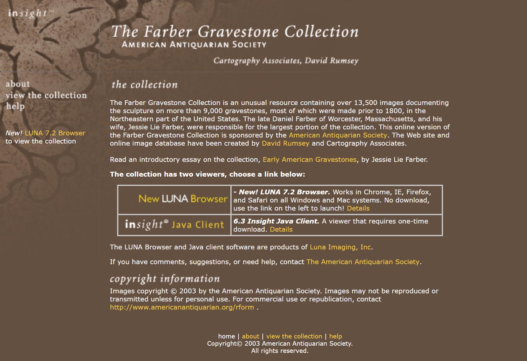
Farber Gravestone Collection
The Farber Gravestone Collection is an unusual resource containing over 13,500 images documenting the sculpture on more than 9,000 gravestones, most of which were made prior to 1800, in the Northeastern part of the United States. The late Daniel Farber of Worcester, Massachusetts, and his wife, Jessie Lie Farber, were responsible for the largest portion of the collection. This online version of the Farber Gravestone Collection is sponsored by the American Antiquarian Society. The Web site and... Read full article

April 1, 2004 - 1,218 New Maps Added
The following are highlights from 1,218 New Maps added to the David Rumsey Collection. All titles may be found by launching the Insight Browser or Java Client and searching under Search/by Publication Author using the author last names below. Or click here to view all 1,218 new maps. Atlas of the Metropolitan District (of New York City), 1891 Bien, Joseph Rudolph; Vermeule, C.C., New York 13 Maps. Covers New York City and the country around it, including parts of New Jersey and Westchester C... Read full article

December 8, 2006 - 1,148 New Maps Added
The following are highlights from 1,148 New Maps added to the David Rumsey Collection. All titles may be found by launching the Insight Browser or Java Client and searching under Search/by Publication Author using the author last names below. Or click here to view all 1,148 new maps. Atlas Nouveau, 1742 Lisle, Guillaume de; Covens & Mortier, Amsterdam 121 maps and text pages. The Amsterdam edition of De Lisle's maps, adding maps by Sanson, Jaillot and others. View Atlas. Or compare this atla... Read full article
Smithsonian and ESRI use Rumsey Maps in New Time Viewer
The online Smithsonian Magazine has partnered with Allen Carroll and Bern Szukalski at ESRI's story maps to create urban history time viewers showing changes in the growth of six American cities using georeferenced maps from the Rumsey Collection (you can read the text of the Smithsonian articles but for links to the interactive maps, use the links below, the links in the articles no longer work). In addition to the Map of New York below, five other cities are shown: Chicago in 1868, Denver i... Read full article

September 1, 2001 - 1,040 New Maps Added
Highlights from 1,040 New Maps added to the David Rumsey Collection. All titles may be found by searching under Search/by Publication Author using the author last names below. Or click here to view all 1,040 new maps. Atlas of the State of New York, 1829 David Burr 51 maps, first edition. One of the earliest State atlases in the U.S.; includes maps of all the counties and a large map of New York City. Atlas fisico y politico de la Republica de Venezuela, 1840 Agustin Codazzi 19 maps, first ... Read full article
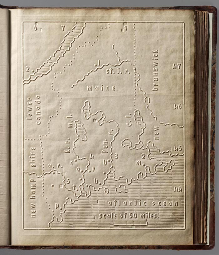
Atlas for The Blind 1837
The Atlas of the United States Printed for the Use of the Blind was published in 1837 for children at the New England Institute for the Education of the Blind in Boston. Without a drop of ink in the book, the text and maps in this extraordinary atlas were embossed heavy paper with letters, lines, and symbols. To the best of our knowledge, this is the first atlas produced for the blind to read without the assistance of a sighted person. Braille was invented by 1825, but was not widely used unt... Read full article
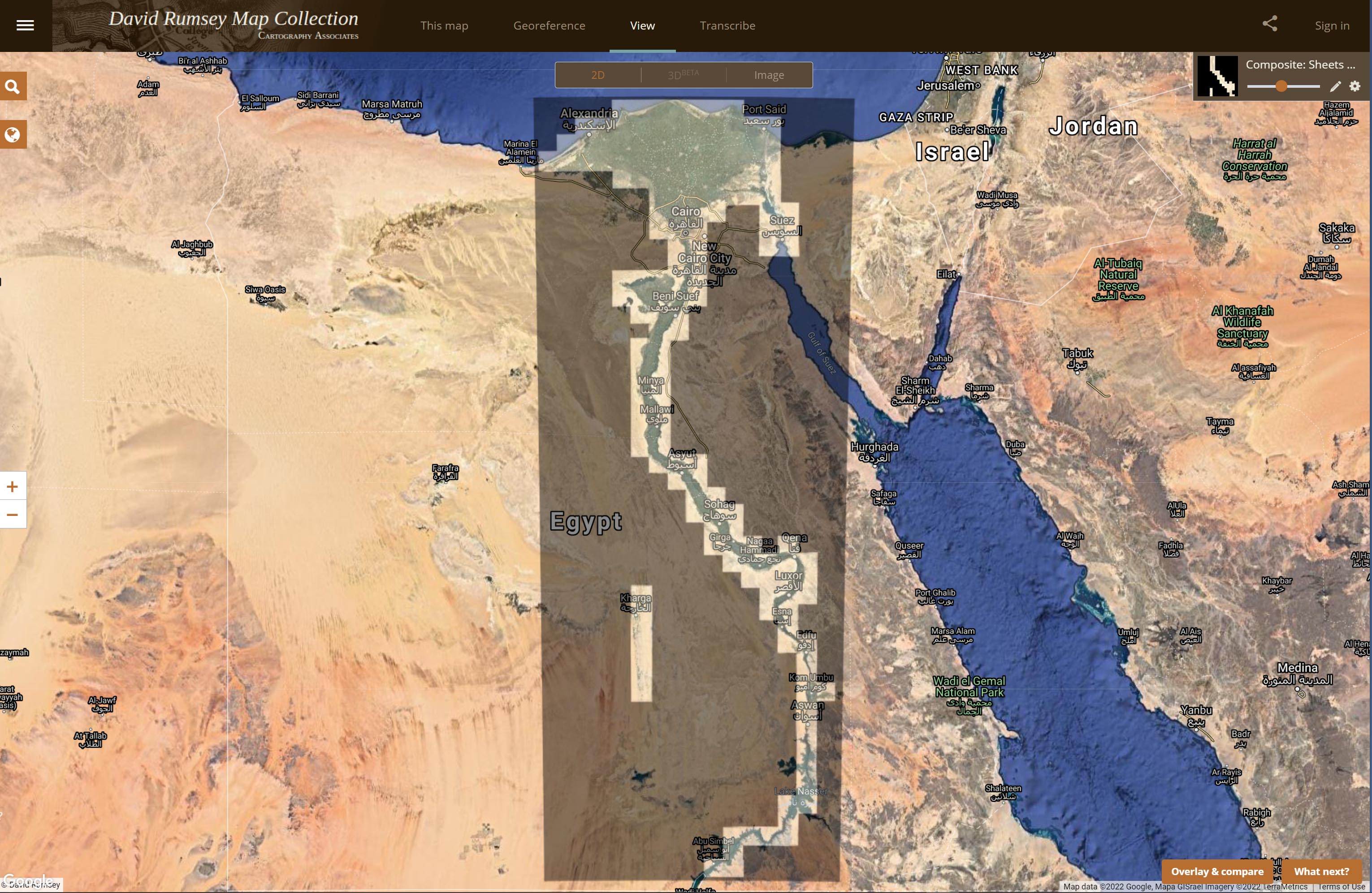
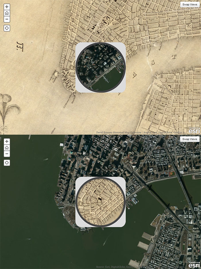
More Than Digital Copies: Maps That Interpret Maps
When we digitize historical maps we create copies that can be shared and used by all. But we also create the potential to repurpose these copies to advance understanding of the original maps. To do this, we create composite maps, georeferenced maps, composite views, interactive globes, composite texts and other types of digital versions that expand map interpretation and enhance use. Below are some examples of these interpretive maps that we have created over the past 20 years. To date we hav... Read full article
August 19, 2013 - 5,359 New Maps Added
5,359 new maps and images have been added to the David Rumsey Map Collection, bringing the online collection to 42,725 maps and related images. Highlights in this addition are Rizzi Zannoni's 1808 Atlante geografico del regno di Napoli; a very early geography game from France, Le Jeu du Monde of 1645; several World Atlases by Stieler; 60 Maritime Charts from the United States Exploring Expedition, 1850; over 900 topographical and geological maps from the 19th and 20th century published by the... Read full article