Search results from Blog
Viewing: Recent Additions
Online Rumsey Downloadable Maps Reach 120,000
The David Rumsey Map Collection online database has grown to over 120,000 maps and related images. Below are over 500 highlights of maps added between 2017 and 2023. Read full article
Online Rumsey Maps Reach 105,000. Part Two - 2017 Additions
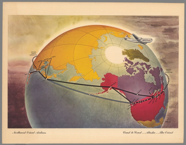
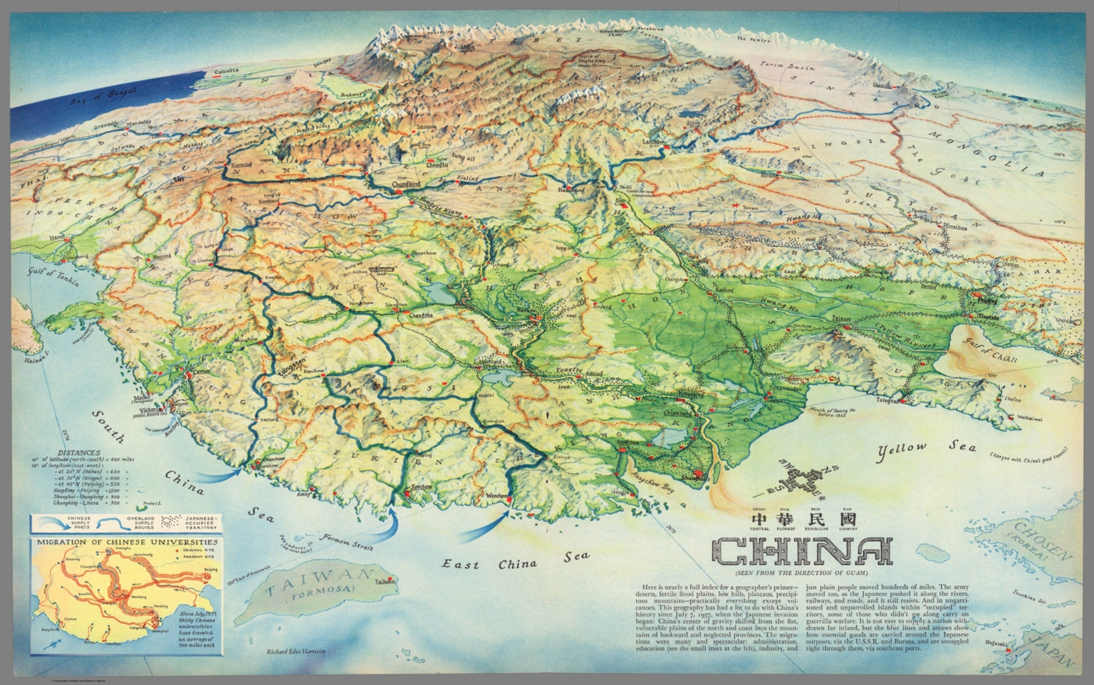
This is Part Two of the blog post documenting the 46,000 new maps and images that have been added online since 2015. The total online collection is now over 105,000. This post covers 50 highlights of additions made in 2017. Later posts will cover the additions made in 2018, 2019, and 2020. All titles may be found by clicking on the View links or images below. China : Chung Hue Min Kuo = central flowery republican country. (Seen from the direction of Guam). Richard Edes Harrison. (inset) ... Read full article
Online Rumsey Maps Reach 100,000. Part One - 2016 Additions
Since the last Recent Additions blog five years ago, more than 41,000 new maps and images have been added online, bringing the total online collection to over 100,000. Because of the large number of maps in this Recent Addition, we are splitting the 41,000 updates into four blog posts of about 10,000 maps each, divided roughly into the years following the last post - 2016, 2017, 2018, and 2019. This post covers highlights of additions made in 2016. All titles may be found by clicking on t... Read full article
April 4, 2015 - 15,342 New Maps Added
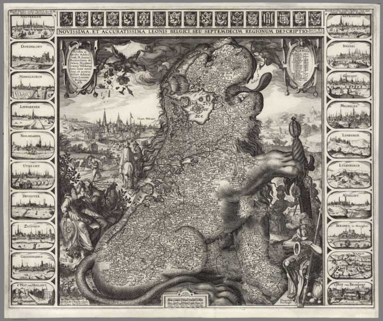
15,342 new maps and images have been added to the David Rumsey Map Collection, bringing the online collection to 58,078 maps and related images. Highlights in this addition are over 2,000 Pictorial Maps; the Claes Janszoon Visscher 1611 Leo Belgicus map; the 1570 and 1608 editions of the Ortelius Theatrum Orbis Terrarum; a massive group of German Invasion plans for England, Wales, and Ireland in WW II; 1682 Map of the areas around Mexico City; 2 important early atlases of Swiss Topography;... Read full article
August 19, 2013 - 5,359 New Maps Added
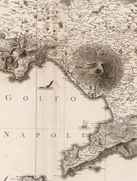
5,359 new maps and images have been added to the David Rumsey Map Collection, bringing the online collection to 42,725 maps and related images. Highlights in this addition are Rizzi Zannoni's 1808 Atlante geografico del regno di Napoli; a very early geography game from France, Le Jeu du Monde of 1645; several World Atlases by Stieler; 60 Maritime Charts from the United States Exploring Expedition, 1850; over 900 topographical and geological maps from the 19th and 20th century published by th... Read full article
February 11, 2013 - 2,745 New Maps Added
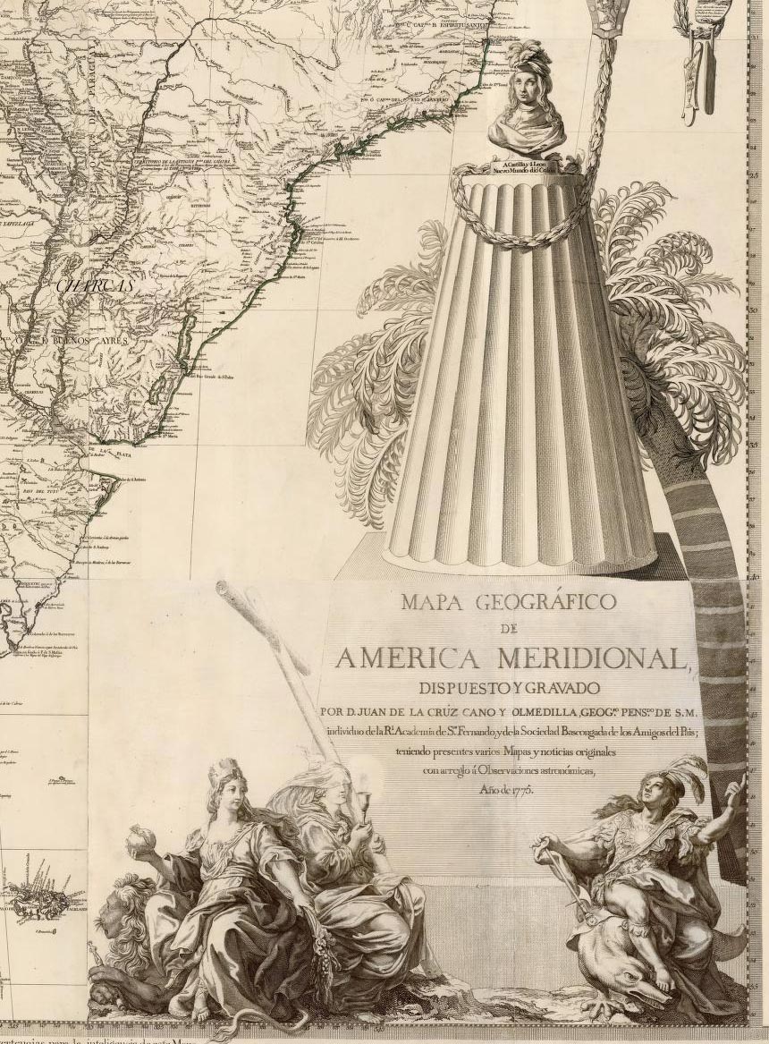
2,745 new maps and images have been added to the David Rumsey Map Collection, bringing the online collection to 37,365 maps and related images. Highlights in this addition are Cruz Cano's large wall map of South America 1775, two miniature atlases from 1758 and 1762, maps by Aaron Arrowsmith, a large group of pocket maps, an important large wall map of Georgia 1818, three copies of Tanner's American Atlas 1823, 1824, 1833, 63 birds-eye views of the Austrian countryside around Vienna 1837, E... Read full article

September 23, 2012 - 2,174 New Maps Added
2,174 new maps and images have been added to the David Rumsey Map Collection, bringing the online collection to 34,595 maps and images. Highlights in this addition are Arrowsmith's Large Maps of Europe, Africa and Asia, 1796 - 1818, Pardies' Star and Constellation Maps of the Heavens, 1693, the five volume 1764 Petit Atlas Maritime by Bellin, Pownall's 1776 Topographical Description, a huge 1845 manuscript map of the New York and New Haven Railroad, a group of Pocket and Guide Maps from 182... Read full article
June 24, 2012 - 1,828 New Maps Added
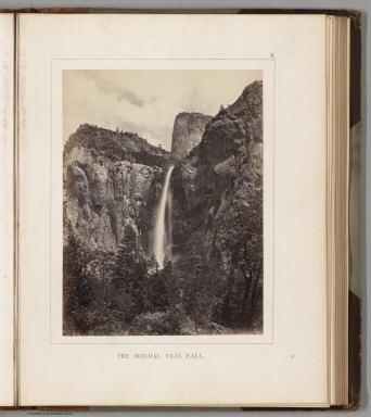
1,828 new maps and images have been added to the David Rumsey Map Collection, bringing the online collection to 32,413 maps and images. Included in this addition are early Yosemite guide books; the Allgemeiner Schulatlas, 1825, a remarkable German school atlas; 216 Maps and Images from Pocket Maps, 1825 - 1920; 12 U.S. County Atlases, 1864 - 1890; The Times Atlas of the World Mid-Century Edition, 1959; Atlas of the United States Printed for the Use of the Blind, 1837; 30 U.S. Civil War maps ... Read full article
March 13, 2012 - 1,596 New Maps Added
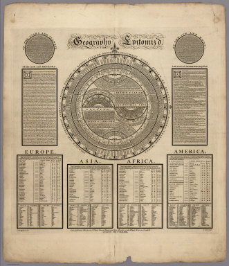
1,596 new maps and images have been added to the David Rumsey Map Collection, bringing the online collection to 30,599 maps and images. Included in this addition is Bowles' 1733 Geography Epitomiz'd, an early example of information visualization; Abraham Bradley's 1805 Post Road Map of the United States; Aaron Arrowsmith's General Atlas of 1817; a group of U.S. Mexican War broadsides and maps; Mitchell's 1855 Universal Atlas; a group of 214 individual maps, charts, broadsides, ephemera, and ... Read full article
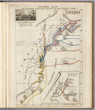
December 21, 2011 - 1,163 New Maps Added
1,163 new maps and images have been added to the David Rumsey Map Collection, bringing the online collection to 29,004 maps and images. Included in this addition is Emma Willard's 1829 History of the United States, one of the first historical school atlases published in the United States; all the illustrations, maps, and plates from the 1861 Ives Expedition up the Colorado River; the 1873 Beers Atlas of Long Island, New York; a fascinating Hieroglyphic Atlas of the U.S.; images and plates fr... Read full article
June 26, 2011 - 1,676 New Maps Added
1,676 new maps and images have been added to the David Rumsey Map Collection, bringing the online collection to 27,800 maps and images. Included in this addition are 666 images of Pocket Maps, a rare edition of Sanborn's 1905 Atlas of San Francisco from the S.F. Public Library which shows the city just before the earthquake and fire of 1906 - the atlas pages show burns from the fire. Also the 1889 Cram Standard American Atlas and the 1901 Cram American Railway Atlas. 325 more images from the... Read full article
March 18, 2011 - 1,634 New Maps Added
1,634 new maps and images have been added to the David Rumsey Map Collection, bringing the online collection to over 26,000 maps and images. Included in this addition are five issues of Colton's General Atlas of the World dated from 1865 to 1886. Also two editions of Schonberg's Standard Atlas of the World, 1865 and 1867. Sheets from two national surveys: six composite images of the entire Wheeler Survey of the U.S. West, 1876, and the first 338 sheets of the massive 19th century survey of G... Read full article
November 27, 2010 - 1,786 New Maps Added
Below are descriptions of 1,786 new maps and images recently added to the David Rumsey Collection. Included for the first time are six new BookReaders that enable page turning books in the Luna software; four of these are new atlases: Popple's 1746 Atlas of North America; Pertermann and Milners's 1850 Atlas of Physical Geography; Williamson's 1870 Removal of Blossom Rock in San Francisco Harbor; and Baker's 1936 Atlas of American Agriculture. Also, two important boundary dispute atlases, the ... Read full article

July 4, 2010 - 564 New Maps Added
Below are descriptions of 564 new maps and images recently added to the David Rumsey Collection. Included are Jacob Green's Astronomical Recreations, an early U.S. celestial atlas published by Anthony Finley in 1824; Finley's pocket map version of his American Atlas, 1827; the graphically stunning Atlas Elementaire by Soulier and Andriveau-Goujon, published in Paris in 1838; a German atlas version of J. Calvin Smith's important Map of the United States from 1852; an extensive geography text w... Read full article

April 12, 2010 - 764 New Maps Added
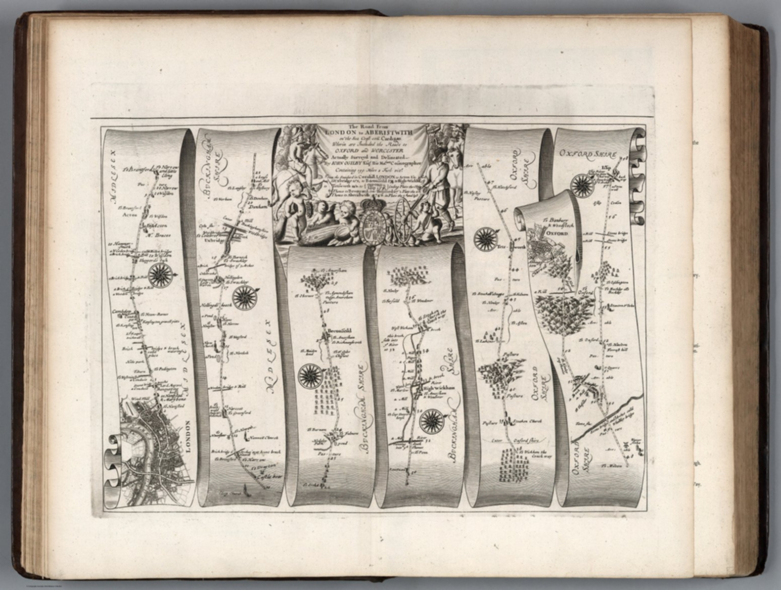
Below are highlights from 764 new maps and images recently added to the David Rumsey Collection. Included are John Cary's 1790 Survey of the High Roads From London - an early use of strip road maps, the Atlas Classique De La Geographie - an 1839 teaching atlas by C.V. Monin with Monin's version of the classic Mountains and Rivers plate by Bulla, and Rand McNally's monumental 1924 Commercial Atlas Of America, with some of the most detailed early highway maps of the U.S. along with extensive r... Read full article

November 20, 2009 - 1,238 New Maps Added
The following are highlights from 1,238 New Maps and Images added to the David Rumsey Collection. Included are John Cary's comprehensive road map of England and Wales from 1794 (plus a composite image joining all 81 sheets), John Wilson's important Map of South Carolina, 1822, Pick's time-line historical chart from 1858, geological and oil maps of Pennsylvania, 2 editions of Rand McNally's Business Atlas, 3 editions of Johnston's Royal Atlas, the atlas edition of Viele's map of New York City... Read full article

March 6, 2009 - 1,572 New Maps Added
The following are highlights from 1,572 New Maps and Images added to the David Rumsey Collection. All titles may be found by clicking on the View links below. Or click here to view all 1,572 new maps. (This link shows 1850 maps and images because some of the new 1,572 items are text pages added to atlases and the entire atlases are shown). Atlas Nouveau, 1742 Covens et Mortier; Lisle, Guillaume de, 1675-172, Amsterdam 107 Maps. The entire text of the bound-in geography has been put online - ... Read full article

August 1, 2008 - 1,038 New Maps Added
The following are highlights from 1,038 New Maps added to the David Rumsey Collection. All titles may be found by clicking on the View links below. Or click here to view all 1,038 new maps. Carte de la France 1790 Cassini, Cesar-Francois, 1714-1784; Capitaine, Louis, ca. 1749-ca. 1797; Cassini family, Paris 5 maps. These maps are a 24 sheet reduction of Cassini's 182 sheet 1750 map, joined together in 4 large sheets of 6 maps each. Includes the key to symbols used in the large Cassini survey.... Read full article

November 28, 2007 - 1,566 New Maps Added
The following are highlights from 1,566 New Maps added to the David Rumsey Collection. All titles may be found by launching the LUNA Browser or Java Client and searching under Search/by Publication Author using the author last names below. Or click here to view all 1,566 new maps. Atlas des ganzen Erdkreises, 1803 Reichard, C. G., Weimar 6 maps. The maps depict the entire earth on a central or gnomonic projection, which shows the globe as six faces of a cube. View Maps Union Atlas, 1813 Dar... Read full article

April 7, 2007 - 1,041 New Maps Added
The following are highlights from 1,041 New Maps added to the David Rumsey Collection. All titles may be found by launching the LUNA Browser or Java Client and searching under Search/by Publication Author using the author last names below. Or click here to view all 1,041 new maps. United States Exploring Expedition, 1845 United States Exploring Expedition (1838-1842); Wilkes, Charles, Philadelphia 84 maps, views, and portraits. These illustrations appear in the five volumes of text that make... Read full article

December 8, 2006 - 1,148 New Maps Added
The following are highlights from 1,148 New Maps added to the David Rumsey Collection. All titles may be found by launching the Insight Browser or Java Client and searching under Search/by Publication Author using the author last names below. Or click here to view all 1,148 new maps. Atlas Nouveau, 1742 Lisle, Guillaume de; Covens & Mortier, Amsterdam 121 maps and text pages. The Amsterdam edition of De Lisle's maps, adding maps by Sanson, Jaillot and others. View Atlas. Or compare this atla... Read full article

March 21, 2006 - 1,048 New Maps Added
The following are highlights from 1,048 New Maps added to the David Rumsey Collection. All titles may be found by launching the Insight Browser or Java Client and searching under Search/by Publication Author using the author last names below. Or click here to view all 1,048 new maps. Nouvelle Metode, la Geographie, 1693 Dangeau, abbe de, Manuscript French Atlas of outline maps by Dangeau, perhaps some of the earliest examples of outline maps used for teaching geography. View Atlas Introducti... Read full article

October 15, 2005 - 1,564 New Maps Added
The following are highlights from 1,564 New Maps added to the David Rumsey Collection. All titles may be found by launching the Insight Browser or Java Client and searching under Search/by Publication Author using the author last names below. Or click here to view all 1,564 new maps. 31 Children's School Atlases ranging in date from 1777 (William Faden, Geographical Exercises, London) to 1875 (Samuel Augustus Mitchell, Ancient Atlas, Philadelphia). Highlights include M.B. Moore, Geographical... Read full article

November 15, 2004 - 1,035 New Maps Added
The following are highlights from 1,035 New Maps added to the David Rumsey Collection. All titles may be found by launching the Insight Browser or Java Client and searching under Search/by Publication Author using the author last names below. Or click here to view all 1,035 new maps. Atlas to Accompany the Official Records of the Union and Confederate Armies, 1895 United States. War Department, Washington, D.C. 182 Maps, views, and plates. Contains reproductions of most of the important maps... Read full article

April 1, 2004 - 1,218 New Maps Added
The following are highlights from 1,218 New Maps added to the David Rumsey Collection. All titles may be found by launching the Insight Browser or Java Client and searching under Search/by Publication Author using the author last names below. Or click here to view all 1,218 new maps. Atlas of the Metropolitan District (of New York City), 1891 Bien, Joseph Rudolph; Vermeule, C.C., New York 13 Maps. Covers New York City and the country around it, including parts of New Jersey and Westchester C... Read full article

June 1, 2003 - 811 New Maps Added
The following are highlights from 811 New Maps added to the David Rumsey Collection. All titles may be found by launching the Insight Browser or Java Client and searching under Search/by Publication Author using the author last names below. Or click here to view all 811 new maps. (Plan of the City of Saint Petersburg), 1753 Akademiia nauk SSSR. 36 Maps and views. This atlas includes a detailed 9 sheet map of Saint Petersburg, shown as 9 separate images plus a composite image of all 9 sheets ... Read full article

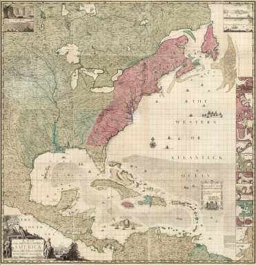
December 14, 2002 - 831 New Maps Added
The following are highlights from 831 New Maps added to the David Rumsey Collection. All titles may be found by launching the Insight Browser or Java Client and searching under Search/by Publication Author using the author last names below. Or click here to view all 831 new maps. United States Of North America, 1808. Arrowsmith, Aaron. A very detailed map of the United States east of the Mississippi River, first published in 1796 and updated in many editions to the mid 1820's. This issue is ... Read full article

August 17, 2002 - 705 New Maps Added
The following are highlights from 705 New Maps added to the David Rumsey Collection. All titles may be found by searching under Search/by Publication Author using the author last names below. Or click here to view all 705 new maps. Railroad and Land Development Maps of Texas, various dates, 1877 to 1892. (Galveston, Texas), Houston and Texas Central Railway, International & Great Northern Railroad, Southern Pacific Company, St. Louis, Iron Mountain, and Southern Railway Company, Texas and Pa... Read full article

December 15, 2001 - 1,012 New Maps Added
Highlights from 1,012 New Maps added to the David Rumsey Collection. All titles may be found by searching under Search/by Publication Author using the author last names below. Or click here to view all 1,012 new maps. Commercial, Topographical, and Statistical Atlas of the United States, 1874 Asher and Adams 41 Maps, most complete edition. This was one of the first United States atlases to exclusively feature railroad lines, showing minimal topography and only showing towns on or next to rai... Read full article

September 1, 2001 - 1,040 New Maps Added
Highlights from 1,040 New Maps added to the David Rumsey Collection. All titles may be found by searching under Search/by Publication Author using the author last names below. Or click here to view all 1,040 new maps. Atlas of the State of New York, 1829 David Burr 51 maps, first edition. One of the earliest State atlases in the U.S.; includes maps of all the counties and a large map of New York City. Atlas fisico y politico de la Republica de Venezuela, 1840 Agustin Codazzi 19 maps, first... Read full article
March 1, 2001 - 1,406 New Maps Added
Highlights from 1,406 New Maps added to the David Rumsey Collection. All titles may be found by searching under Search/by Publication Author using the author names below. Or click here to view all 1,406 new maps. Atlas General, 1771 Monsieur d'Anville 48 maps, including several important maps of the Americas. South America, 1814 Aaron Arrowsmith The huge (over 8 feet tall) six sheet wall map originally issued in 1811. Times Atlas of the World, 1922 John George Bartholomew 117 maps, the secon... Read full article

July 1, 2000 - 706 New Maps Added
Highlights from 706 New Maps added to the David Rumsey Collection. All titles may be found by searching under Search/by Publication Author using the author names below. Or click here to view all 706 new maps. London Atlas, 1844 John Arrowsmith 65 maps, including his Map of Texas and 4 important maps of Australia and New Zealand. Complete System of Geography, 1747 Emanuel Bowen 70 maps, including 18 early maps of North and South America and the West Indies. Illustrated Atlas of the United Sta... Read full article