georeferencer
Fix Location of a MapGeoreferenced MapsGeoreferencer CompareHelp
Georeferencer v4 is an improved and updated version of our prior Georeferencer v3. It allows you to overlay historic maps on modern maps or other historic maps. The overlaid maps reveal changes over time and enable map analysis and discovery. New features in v4 include georeferencing several maps on one sheet, Grid view to compare multiple maps, Swipe and Spy Glass views, built in 3D viewer, Transcribe and GeoEditors, and all new Georeferencer Compare view. You can choose your own maps to georeference by Searching LUNA and using the Georeference This Map button or help us georeference the entire online map library using our Random Map link to georeference maps in our First Pilot Project of 6,000 maps of major cities and regions. Users who georeference the most maps will be recognized in the bar displays below. Recently Georeferenced maps can be viewed by image or by location.
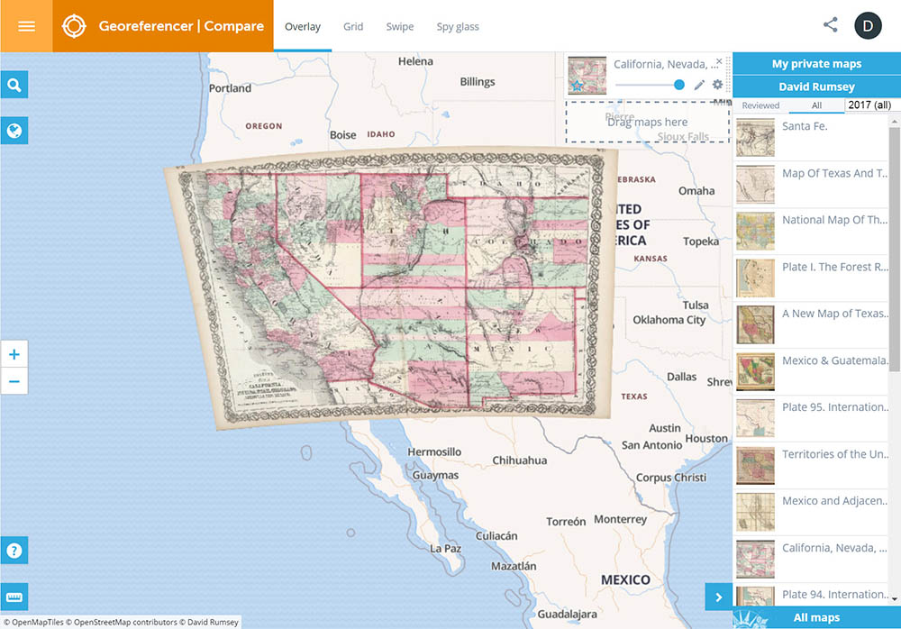
Georeferencer v4 has two windows: the Georeferencer Compare window and the This Map/Georeference/View window. The Georeferencer Compare window allows searching for maps from various sources, then comparing them using several different views - Overlay, Grid, Swipe, and Spy glass.
Georeferencer Compare window: (click to open)
 |
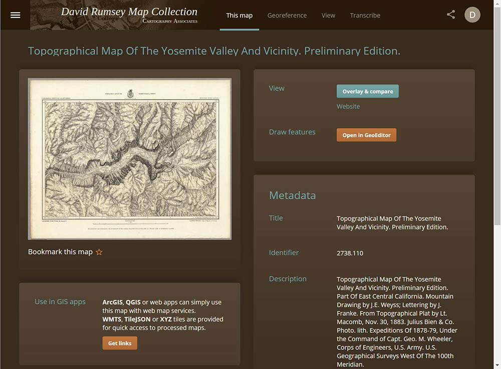
The This Map/Georeference/View window allows you to georeference maps, view maps in 2D and 3D, geoedit maps, get map links for GIS apps, Transcribe annotations on the maps, and more.
This Map/Georeference/View window: (click to open)
 |
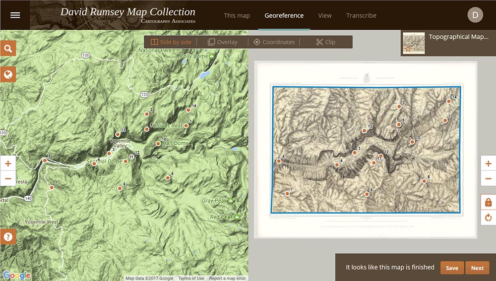
The images below of Yosemite Valley 1883 show methods used.
 |
1. To get started, click on either the orange button below "Fix Location of a Map" or the "Search LUNA..." button. If you search Luna and find a map you want to georeference, open it in the zoom view window and click on the orange button "Georeference this map." If the map has already been georeferenced the button will say "View in Georeferencer." There will be many help screens that will show the process of georeferencing the maps as you move through the steps.
2. Enlarge the old and modern maps to find matching town names, street names or other places and assign common points to each maps. At least three points are required, and the more points you assign, the better the georeferencing will be. Use the search box in the modern map to find places listed on the old map. Spread you points over the largest possible area.
3. After assigning at least three points, click on the "Clip" button in the old map window to draw blue lines around the content area of the map. The Clip lines should be just inside the border of the map.
4. When finished, click on the "Save" button (although the map will save automatically). Then choose the View This Map or the Overlay & Compare page to see the map.
5. In the View This Map page chose 2D or 3D or Image views. For the 3D view you need to sign in (or set up free account).
6. In the Overlay & Compare page (Georeferencer Compare) you can view one map or search for maps from various sources, and then compare them using several different views - Overlay, Grid, Swipe, and Spy glass.
7. From the This Map pages, use the GeoEditor to locate and measure areas, distances, locations, and more. Use the Transcribe feature to annotate the maps.
8. For more detailed Help, see our Georeferencer Help Page. If you find bugs or problems, use the Hamburger drop down menu in the upper left corner of all screens to send us a message about the problem with the Send Feedback tab.
Klokan Technologies developed Georeferencer with the Moravian Library. You can combine and compare maps from many other libraries using the Old Maps Online tab in the Georeferencer/Compare pages along with maps from our collection. Soon you will be able to upload your own maps and georeference them. Those maps will then show up in your My Private Maps list.
Fix Location of a MapSearch LUNA for a map to Georeference
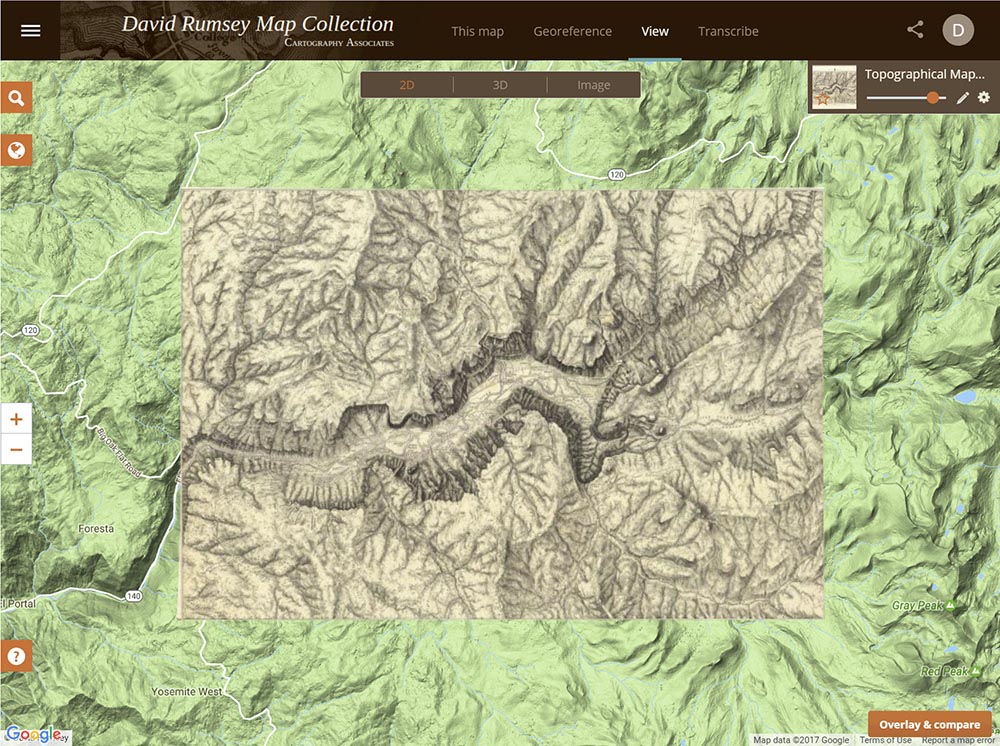
The Georeferencer View This Map page below shows the 2D view of the Yosemite Map 1883 with transparency slider. Click on the image to go to the View This Map page in Georeferencer for this map:
 |
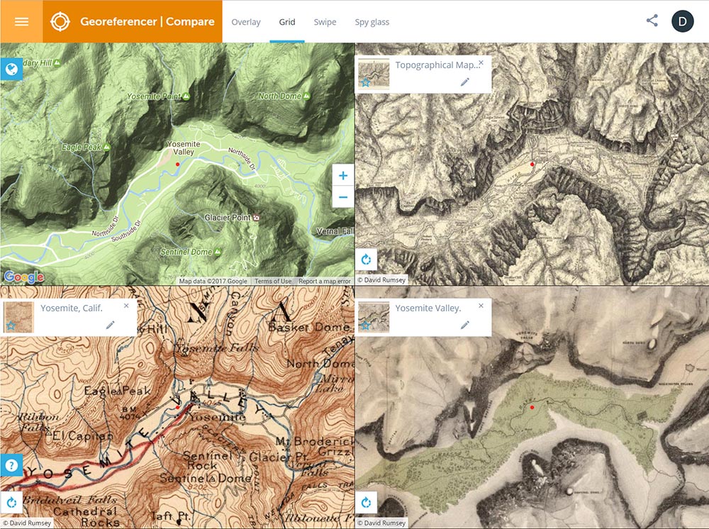
The Georeferencer Compare page below shows a Grid view of four maps of the Yosemite Valley made at different times from the present back to 1868. Click on the image to go to the Compare page Grid view in Georeferencer for this map:
 |
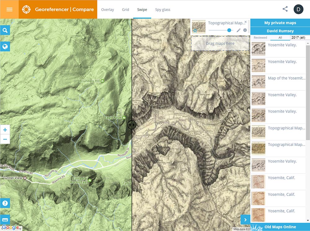
The Georeferencer Compare page below shows a Swipe view of two maps of the Yosemite Map - the present day map and the 1883 map. Click on the image to go to the Compare page Swipe view in Georeferencer for this map:
 |
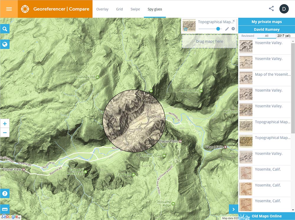
The Georeferencer Compare page below shows a Spy Glass view of two maps of the Yosemite Map - the present day map and the 1883 map. Click on the image to go to the Compare page Spy Glass view in Georeferencer for this map:
 |
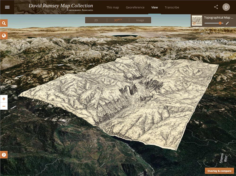
The Georeferencer Compare page below shows a 3D view of the Yosemite Map. Click on the image to go to the 3D view in Georeferencer for this map (requires sign in to a free account):
 |
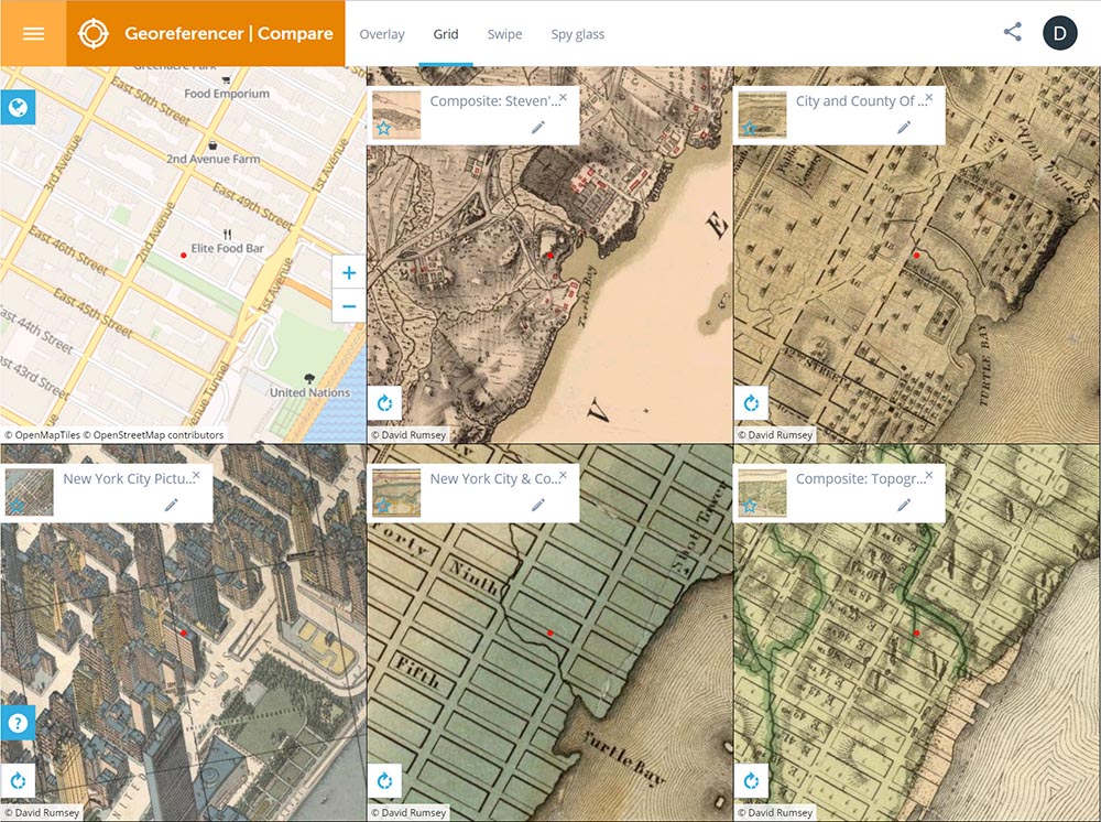
The Georeferencer Compare page below shows a 6 panel Grid view of 6 maps of New York City - from the present day back to 1782. Click on the image to go to the Compare page Grid view in Georeferencer for this map:
 |
Progress of Georeferencing of All Maps
Top Contributors and Charts All Time
Top Contributors Past Week
Recently Georeferenced Maps
Georeferenced Map Finder