 |
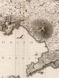
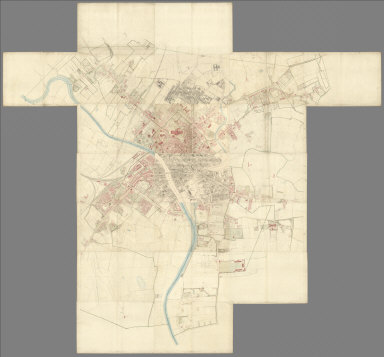
Atlante geografico del regno di Napoli, 1808
Rizzi Zannoni, Giovanni Antonio, Naples
Rare atlas published by the famous cartographer Rizzi Zannoni (1736-1814) during more than 20 years of business in Naples, first as a Geographer of the King and then director of the Topographical Office in Naples in 1781. The maps are based on trigonometric survey and represent a new level of accuracy for Italian mapping. The Cassini projection is used. Title vignette on plate 2. Plates are dated next to the engraver (Giuseppe Guerra) and despite the indication given in the title (1808), were published between 1788 and 1812. The atlas consists of 31 plates, each double page. With views of different sailing ships on each plate. Plates are not numbered, the first plate untitled, showing northern Italy, the second and third plates, also on two pages (which join to make one map), have titles: Carta del’ itinerarj militari da Bologna a tutto il Regno di Napoli ordinata da S.M Giuseppe Napoleone I. Diretta dal Gen. Div. Parisi costruita da P. Colletta Ten. Cotto del Genio.’ View Composite Map of 31 plates. View Entire Atlas View Composite Map in Google Earth
|
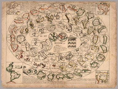 |
Le Jeu du Monde, 1645
Duval, Pierre, Paris
This is one of the earliest geographical games that we have seen. Only one other copy is known of this game, held by the Bibliothèque Nationale de France. The object of the game is to progress from the outer parts of the world in towards the center (France) by rolling dice and moving each player's piece from circle to circle on the board. California is shown as an island in the circle. Duval also made a similar game of France. View Game
|
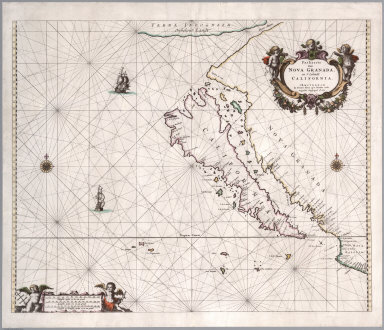 |
Paskaerte van Nova Granada, en t'Eylandt California, 1666
Goos, Pieter, Amsterdam
First issue of this important map showing California as an island. R.V. Tooley referred to the map as "Perhaps the most attractive and certainly the most definite representation of California as an island. California is the centre and 'raison de'etre' of the map." One of a few maps to focus exclusively on California as an island, first published in Goos' De Zee Atlas ofte Water-Weereld. "With the similar Joannes van Loon chart of the same year, this is one of the most desirable of all California as an island maps..." (Burden). Reissued in 1668, 1669, 1670, 1675, 1676. View Map
|
 |
Histoire Philosophique et Politique Des Establissements et Du Commerce Des Europeens Dans Les Deux Indes (with) Atlas De Toutes Les Parties Connues Du Globe Terrestre, Dresse Pour L'Histroire Philosophique et Politique des Etablissemens et du Commerce des Europeens dans les Deux Indes, 1780
Raynal, G.T.; Bonne, Rigobert, Geneva
Text is first edition; Atlas is 1820 revised edition. The atlas was first issued in 1780 with maps engraved by Andre, then reissued in 1783-4 (P5995) without Andre or Bonne on the maps, finally reissued in 1820 with the maps reengraved by Dien (Tooley Dictionary)(our copy of atlas). WH has copies of the 1780 and 1783-4 atlases. It is strange that map #2, the World map, in our copy is an earlier map than the first and second editions of the atlas. Sabin shows many reissues of the 1780 edition of the atlas, so there may be more editions and states than these three. The earlier editions of the atlas were accompanied by twenty three tables in the back. Our copy of the text is 12 mo. and was given as a student prize. Maps are uncolored. Atlas bound in quarter leather with "Raynal. Atlas." in gold on spine. View Atlas
|
|
|
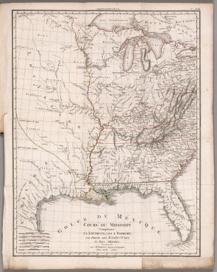
Statistique Generale et Particuliere De La France et De Ses Colonies, avec une Nouvelle Description ..., 1804
Poirson, J.B.; Herbin de Halle, Etienne de., Paris
The important map in this book is Poirson's "Cours De Mississippi Comprenant La Louisiane, Les 2 Florides, Une Partie Des Etas-Unis, et Pays Adjacents." One of the last French maps of Louisiana before it was transferred to the United States. Wheat calls the map "of great interest" in its "display (of) the concept of Louisiana, and especially Missouri, current in French official circles just before the transfer of the Province to the United States." The remainder of the maps, all of which are in outline color, show French holdings throughout the world. Bound with half leather boards, the title on the spine. View Atlas
|
|
|
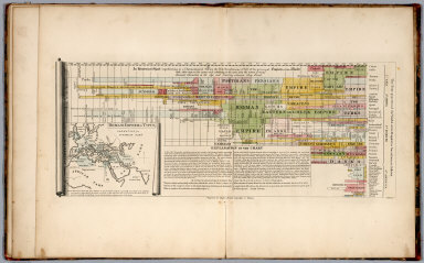
An Atlas Of Ten Select Maps Of Ancient Geography Both Sacred And Profane; With A Chronological Table Of Universal History & Biography, 1815
Mellish, John, Philadelphia
Maps copied from Wilkinson's Atlas Classica. This becomes the Finley Ancient Atlas. Lucas also used many of these maps in his General Atlas of 1823. Covers are half leather, marbled paper covered boards. Includes a timeline map based on Joseph Priestley's timeline. View Atlas
|
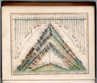 |
A General Descriptive Atlas Of The Earth, Containing Separate Maps Of The Various Countries And States, 1832
Dower, John; Higgins, W.M., London
Unrecorded Dower Atlas, Commentary by Higgins. See Tooley Mapping Australia for mention of these maps of Australia and Tasmania, though he mis-dated them and did not mention this Atlas as the source of the maps; perhaps they were published separately as well. 12 of the maps appear later in lithographic form in Dower's Short Atlas..for Schools. Unusual Mountains and Rivers Plate facing the title page. See Dower's 1854 General Atlas for the same maps, updated. View Atlas
|
 |
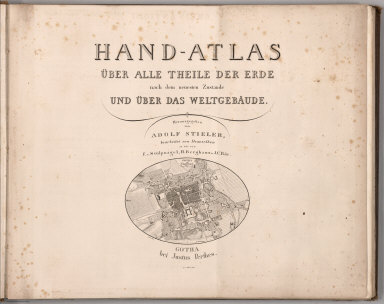
Hand-Atlas uber alle Theile der Erde, nach dem neuesten Zustande und uber das Weltgebaude, 1833
Stieler, Adolf, Gotha
Zero or first edition of Stieler Atlas published 1817-1833 in three versions. 1817-23 (version 0.a), 1823-31 (version 0.b), 1831-33 (version 0.c). Publication went through ten editions from 1816 to 1944. This version published in 2 parts then augmented with two further supplementary installments, through 1833. Most maps have the year of first edition. This edition compromises 90 sheets, dated 1816-1835, including composite index map, and extraordinarily detailed maps and supplements. View Atlas
|
 |
Map sheets of Wuerttemberg, Southwest Germany, and Northern Italy, 1838 - 1840
Woerl, Joseph Edmund; Herder, Benjamin, Freiburg im Breisgau
Maps of southwestern Germany by Joseph Edmund Woerl, mapmaker in Freiburg 1830-1838. An important document about the road network. Red lithographic stone printing is laid on top of highly detailed black lithographic printing. In 23 parts (20 maps 43x46, a title page with decorative illustrations, sample maps and coat of arms, index sheet, and table) placed in cardboard case 54x64, with title "Woerl Atlas der Wuerttemberg." All the maps are at the same scale (1:200,000) and fit together into either one very large composite of all 48 maps or sub-maps of Switzerland (19 sheets plus title, see our 6824.000), Wurtttemberg (12 sheets including title) and Baden. We do not have all 48 maps but rather 24 in this group and 19 in the Switzerland group (although 3 maps appear in both groups, so our net total maps is 39 of 48). Included also are Woerl's maps of Northern Italy. View Maps
|
 |
Kriegsstrassen Karte eines Theiles von Russland, 1837, 1854, 1870
Schubert, Friedrich Theodor, Wien
A rare and important military map covering nearly the whole of European Russia and parts of neighboring countries in great detail, by the famous Russian military cartographer Theodor Friedrich Schubert [Fedor Fedorovic Subert] (1789-1865), here in the Austrian edition published in Wien in three versions, the original first edition 1837, the updated 1854 edition, and another version of the map that was hand updated by an owner (we presume) to about 1870. View Maps
|
|
|
Nach Angabe und auf Kosten des Verfassers der Darstellung des Erzharzofthums Osterreich unter der Ens. (The depiction of the Archduchy Austria below the Enns), 1837
Schweickhardt, Franz Xaver, Vienna
This is same map as our 6937.000 but here dissected in unbound sheets. Each sheet has a booklet of text that explains the history of the area covered by the sheet. An extraordinary group of 63 birds-eye views of the Austrian countryside that all fit together into one very large image (we also have the composite image of all 63 joined). The views show the cultural landscape of the period in great detail, with settlements, buildings, roads, trees, and other features. View Maps View in Google Earth
|
 |
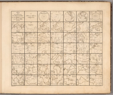
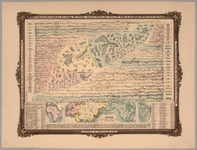
The People's Atlas, Shewing The Relative Extent And Divisions, The Boundaries, And Other Geographical Details Of The Various Empires, States, And Quarters Of The World, Agreeably To The Best Authorities, And In Accordance With A Comparative View Of The Heights Of Hills And Lengths Of Rivers, 1848
Lothian, John, Glasgow
John Lothian was an Edinburgh geographer and publisher who issued atlases of Scotland and its counties from 1825 to 1835, and a General Atlas in 1834 (R. Baskes). Tooley and British Museum list an 1846 edition of this atlas, probably the first. This 1848 second edition is a late production for Lothian, engraved in the style of the Society for the Diffusion of Useful Knowledge (SDUK), but lithographed, with considerably less detail. On first glance the maps appear to be derived or copied lithographically from other maps of the period, but no engraver credit is given and we can not find any source maps. The mountains and rivers plate is unusual - it is a schematic representation that is decidedly "modern" in style. View Atlas
|
 |
Map of New Castle County, Delaware, from Original Surveys, Saml. M. Rea & Jacob Price. Published by Smith & Wisar, No. 15, Minor St., Philadelphia. 1849. (inset) Plan of the City of Wilmington. Compiled from Surveys by G.R. Riddle, C.E. 1847. Reduction by Rea & Price. Entered ... 1848 ... by Robert P. Smith, 1849
Rea, Samuel M.; Price, Jacob, Philadelphia
This is one of the earliest county wall maps produced in the United States (Ristow). Hand colored map mounted on linen with decorative black sticks at top and bottom. Hand tinted. View Map
|
 |
A New Universal Atlas containing maps of the various empires, kingdoms, states and republics of the World. With a special map of each of the United States, plans of cities &c., 1850, 1857, 1864
Mitchell, Samuel Augustus, Philadelphia
Three editions of Mitchell's New Universal Atlas. The 1850 edition is very unusual in having 2 sets of maps of the United States, Texas, and California. One of the U.S. maps has the very rare depiction of the proposed state of Deseret as a home for the Mormon settlements, covering parts of present day Nevada, Utah, and Arizona. The 1857 edition shows early county formations on the California map. And the 1864 edition is special in being the last known (so far) edition of the long atlas run, and includes a double page map of Kansas Territory. View Atlases
|
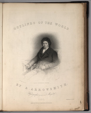 |
Outlines Of The World. By A. Arrowsmith, Hydrographer to His Majesty. 1850. Published Jany st. 1847, by G.F. Cruchley, Mapseller, 81 Fleet Street, London. Addition to 1850
Arrowsmith, Aaron Jr., London
2nd edition, first was 1825 (see our 2550.000). The first edition was issued in the year following the elder Arrowsmith's death in 1824, and dedicated to him. As with the first edition, there is a portrait of A. Arrowsmith Sr. in this second edition and all of the maps appear to have been updated, showing changes in the intervening 25 years. View Atlas
|
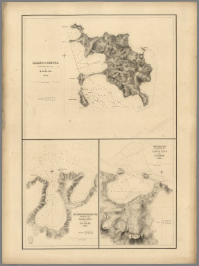 |
60 Hydrography Charts from the The United States Exploring Expedition, 1850
Wilkes, Charles; United States Exploring Expedition, Washington, D.C.
A set of 60 loose sheets (our Pub List Nos. 6941.000-7000.000) printed for individual sale on heavy paper. The charts of islands in the Pacific are likely some of the most detailed at the time (1840). The charts were also published on thinner paper as Vol. XXIII - Hydrography - Wilkes - Atlas of Charts - Vol. I and Vol. II, of The United States Exploring Expedition, 1838-1842. These 60 are not a complete set which consists of 106 unnumbered charts. For more information on the controversial expedition commander Charles Wilkes (1789-1877), the expedition's discoveries, and the resultant publications, see the 1968 bibliography of the expedition by Daniel C. Haskell entitled, "The United States Exploring Expedition, 1838-1842 and Its Publications 1844-1874". Relief shown in hachures. Many maps include horizontal views of islands as seen from a ship. View Charts
|
 |
Atlas zu Alex. V. Humboldt's Kosmos in zweiundvierzig Tafeln mit erlauterndem Texte, 1851
Bromme, Traugott, Stuttgart
This atlas was not overseen by Humboldt (WH) and was not published with Humboldt's text. A later edition was issued in 1861. Maps in full color with a few historical and thematic maps at the beginning and end. As a physical atlas it has many interesting maps. View Atlas
|
 |
Hand - Atlas Uber Alle Theile Der Erde nach dem neuesten Zustande Und Uber Das Weltgebaude. Herausgegebenn von Adolf Stieler, berbeitet von Demselben, so wie von F.v. Stulpnagel, H. Berghaus u. J.C. Bar., 1851, 1853, 1881
Stieler, Adolf, Gotha
Three editions of Stieler's Hand - Atlas over a thirty year period in the mid 19th century. Stieler's maps are some of the most detailed and sophisticated of the period and many of the maps join to make large composite maps. View Atlases
View all Stieler Atlases in the Collection
|
|

|
York. Surveyed in 1850, by Captain Tucker; R.E. Engraved in 1851, under the direction of Captain Yolland, R.E. at the Ordnance Map Office, Southampton, and Published by Lt. Colonel Hall R.E. Superintendent, 1st. Sept., 1852
Great Britain. Ordnance Survey; Tucker, Henry, Southampton
This set of large scale plans of York, Yorkshire, was surveyed between 1849 and 1851 by Captain Tucker R.E. for the Ordnance Map Office. Hand colored highly detailed, folded to 66.5x49, mounted on cloth. Shows roads, railroad, rivers, telegraph lines, layout of buildings, arched passage, churches. Buildings are colored red for masonry and gray for those of wood or iron construction, with glass buildings shown by cross-hatching. etc. The plan is drawn at a scale of five feet to one statute mile, or 60 inches to 1 mile (1:1056). The Plan was published in 21 separate sheets in September and October 1852. The sheets show in great detail the built city of York at the time of industrialization in the mid 19th century. The Ordnance Survey mapped about 4,000 cities and towns in England and Wales at a scale of 1:1056 in the 1850's and towards the end of the 19th century mapped many cities at the larger scale of 1:500. The quality, accuracy, and design of the maps far exceeds the commercial productions made of cities in the United States by Sanborn, Bromley, and others, although the U.S. productions had more detailed use information for insurance purposes. Of this set, sheets 5 and 12 are imaged from copies at the National Library of Scotland. View Maps
|
|

|
Atlas of Australia with all the Gold Regions: a series of maps from the latest and best authorities. Edinburgh, Adam and Charles Black, North Bridge, booksellers and publishers to the Queen, 1853
Black, Adam & Charles, Edinburgh
Atlas with 6 hand-colored engraved maps (5 double-page, one folded), and publisher's advertisements (dated 1853) at end. Bound in tan olive cloth cover, with gilt-blocked map of Australia, and no title on cover. These maps also appeared in Black's General Atlas of 1854 (see our 2305.000) The maps show the recently discovered gold regions in New South Wales, Victoria, and South Australia. View Atlas
|
|
|
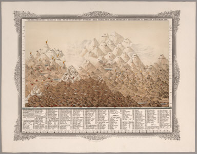
Vergleichendes Tableau der bedeutendsten Hoehen der Erde, von Prof. C. Desjardins. 4te Auflage. Munchen 1855. Zu haben in Wien bei Joseph Bermann am Graben (fur ganz Osterreich.), in Munchen bei May und Widmayer (fur Deutschland), 1855 (with)
Vergleichendes Tableau der Lange der Strome und der Grosse der Seen der Erde in geograph. Meilen zu 15 am Grad. Kartchen zur Berichtigung des wahren Laufes der Strome des Tableau mit den correspondirenden Rangs-Zahlen. Bearbeitet von Prof. Const. Desjardins. Verlag von J. Bermann. Ged., bei. L. Forster, 1855
Desjardins, Constant, Wien
Rare color charts framed in decorative borders. The first showing comparative table of the greatest Mountains and Volcanoes of the world. Extensive table indicating their relative heights with corresponding numbers. The second showing comparative table of the length of the rivers and lakes of the world. The lakes and rivers of the Eastern Hemisphere are shown on the left, with lakes and rivers of the Eastern Hemisphere on the right. Includes notes, and tables indicating correct run of the currents with corresponding numbers. View Maps
View all the collection's Mountains, Rivers, and Lakes Maps
|
|
|
The Physical Geography of the Sea. By M.F. Maury, LL, D., U.S.N., Superintendent of the National Observatory. An Entirely New Edition, With Addenda., 1857
Maury, Matthew Fontaine, London, New York
Maury was one of the first cartographers to study and show winds and currents systematically on charts. This copy is the sixth edition, the first being 1855. Maury's book was a popular work that went through twelve editions. Maury also made large wind and sea charts of the North Atlantic (15 sheets) and the North Pacific (10 sheets). View Maps
|
|


|
Climatology of the United States, And of the Temperate Latitudes of the North American Continent, 1857
Blodget, Lorin , Philadelphia
Blodget was one of the first to bring together statistics on climate and put them in visual form on maps. His maps made it possible to easily relate climate differences in the United States to place and time. First important work on this subject. Maps uncolored except for climatological information which is shown in red. Cloth covered boards with "Blodget's Climatology of the United States" on spine. View Maps
|
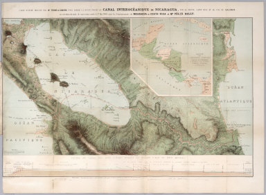 |
Carte D'Etude Pour Le Trace Et Le Profil De Canal De Nicaragua, 1858
Belly, Felix; Gamond, Thome, Paris
Felix Belly was the most prominent proponent of a canal through Nicaragua. This book and beautiful map is a promotion for his scheme, which never achieved success during his time, yet was still being promoted well into the twentieth century. The full color map, 64x92, is a stunning example of early chromolithography, and is titled "Carte D'Etude Dressee Par Mr. Thome Gamond Pour Servir A L'Avant-Project Du Canal Interoceanique De Nicaragua..." The inset map is titled "Carte L'Amerique Centrale..." Along the bottom of the main map is a profile of the canal. The book is an inscribed presentation copy from Belly to a "Monsieur Mason." View Map
|
 |
A Group of 10 Maritime Charts from all parts of the World, 1807 - 1882
Various Authors, Various Places
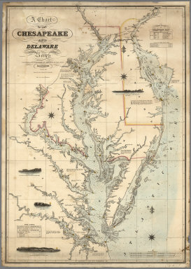
10 sea charts, ranging from an early Arrowsmith 1807 Chart of the Chart of Shetland Isles and Orkney Islands, to a British Admiralty 1882 Chart of Charleston Harbour. Of particular interest is James Imray's 1849 Chart of the North Pacific Ocean, showing detailed insets of San Francisco Bay at the time of the California Gold Rush. This chart was evidently aboard the ship, Northern Light, an American Clipper ship. Handwritten on the chart are the ship's locations on a round trip from San Francisco - Acapulco (March-April,1852) and thence toward Boston in May 1852. The ship returned to San Francisco and the following year, 1853, she sailed from San Francisco, California to Boston, Massachusetts via Cape Horn with Captain Freeman Hatch at the helm in a record-setting 76 days, 6 hours. The record still stands for a single hull vessel. Another chart in the group is Fielding Lucas's beautiful 1862 edition of Chart of the Chesapeake And Delaware Bays, a later edition of the 1840 chart of the same name.
View Charts
|
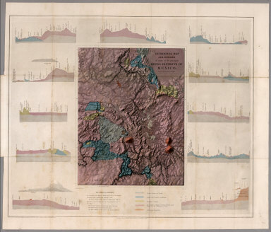 |
Contributions to the Geology and the Physical Geography of Mexico, including a Geological and Topographical Map, with profiles, Of some of the principal Mining Districts; together with a graphic description of an ascent of The Volcano Popocatepetl, 1864
Egloffstein, Baron F.W. von, New York
Includes two beautifully engraved maps of the region including Mexico City, showing the topography of the area and then with a geologic overlay. The maps are engraved in the special style pioneered by Egloffstein (see all Egloffstein maps and views). View Maps
|
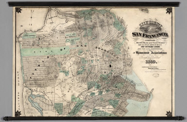 |
City and County of San Francisco. Compiled from U.S. Land and Coast Surveys from the Official Surveys of the City, The Outside Lands. The Tide Land Commission and the Homestead Associations, 1869
Goddard, George H., San Francisco
Shows in tint the tidelands, homestead areas, parks, and cemeteries. There is property information and street layouts that appear to be unique to this map, compared to other San Francisco maps of the same period. A rare map. View Map
|
|

|
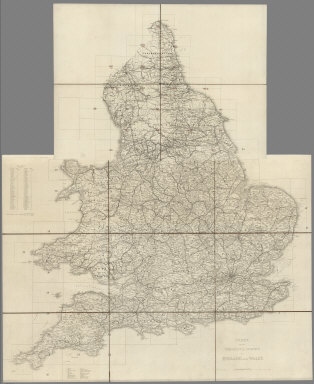
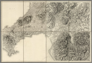
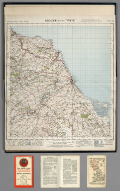
Ordnance Survey of Great Britain. Old Series or First Edition, One-Inch Map of England and Wales, 1870
Great Britain. Ordnance Survey; Mudge, William (1762-1820); Colby, Thomas; Baker, Benjamin; Great Britain. Board of Ordnance, London, Southampton
Dates are estimated. Complete set of published 110 maps in Old Series or First Edition. This set is the first systematic survey of England and Wales based on triangulation. It was inspired by the prior Cassini survey of France (see our 5694.000) and the threat of French invasion at the end of the 18th century. The survey sheets were originally published from 1805 to 1870 and frequently updated; our sheets range in date from approximately 1848 to 1870. By 1870 all sheets in the Old Series had been completed (excepting sheet 100, Isle of Man) and thus our set is one of the first complete sets made up of a mix of map states, with the railroads added, which was started in the 1840's. Of the 110 sheets, 54 were issued as full sheets and the remaining 56 as quarter sheets. Sheets 1 and 100 added to set by us (Sheet 100, Isle of Man, was the last sheet published, after our set was assembled, in 1874). Exact dates are frequently ambiguous since old dates were left on in subsequent editions and most editions were not explicitly dated. Our set previously owned by Austrian Archduke Leopold Ludwig (1823-1898) and is from his library with his bookmark stamp. The Old Series actually consists of multiple editions or "states" for the map sheets corresponding to various publication dates; many of these states are characterized in detail in the eight-volume set, "The Old Series Ordnance Survey Maps of England and Wales, Scale 1 inch to 1 mile. A Reproduction of the 110 Sheets of the Survey in Early State in 8 Volumes", 1991, published by Harry Margary, Lympne Castle, Kent, Our map set has no dates (having been previously trimmed with the marginalia) so we have used the Margary work and also the March, 2013, Draft 599-page "Provisional Cartobibliography" an untitled followup publication of the The Charles Close Society to research which edition (date) we have for each sheet and subsequently have written it on the back of each sheet and entered it in the Date field of this catalog. The set shows a remarkably large number of Roman roads, camps, sites, roads in detail, railways; relief by hachures with spot heights; rivers and creeks; place names, settlements; geological symbols. From 1841 sheets were published in Southampton. Our sheets appear to have been issued just before the general updating of the sheets by electrotyping in the late 1860's. View Maps
|
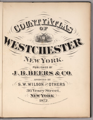 |
7 County and City Atlases, 1872 - 1913
Various Authors, Various Places
A group of seven county and city atlases. Includes Beer's Westchester County, 1872; Pictou County, Nova Scotia, 1879; Saratoga and Ballston, New York, 1876; Newport, Rhode Island, 1876; Halifax, Nova Scotia, 1878; Will County, Illinois, 1873; and Rand McNally's Chicago, 1913.
View All Atlases
|
|


|
Maps of the First through Sixth Operating Divisions of the Western Division, Atlantic & Pacific Railroad, Albuquerque, New Mexico, to Mojave (Mohave), California, 1882
Atlantic & Pacific Railroad
A set of six hand-drawn maps on semi-transparent waxed linen with some color. Some areas are colored on the verso to highlight the areas in a muted style. We think that some type of backlighting was planned to be used to create a photolithographic plate from which printing would be done. No evidence was found that it was ever printed. These sheets were de-accessioned from the Santa Fe Railroad collection in the 1980s. Lewis Kingman did the route survey from Albuquerque to Needles. Relief shown by hachures. View Maps
|
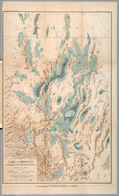 |
Department of Interior : Monographs of the United States Geological Survey, vol. XI. House of Representative : 49th Congress, 1st Session. Mis. Doc. No. 304. Washington : Government printing Office 1885. Geological history of Lake Lahontan : a quaternary lake of Northwestern Nevada ; by Israel Cook Russell. (at head to title) United States Geological Survey; J.W. Powell, Director. .
Russell, Israel C. (Israel Cook), Washington, D.C.
Geological history of Lake Lahontan, published in U.S.G.S. Monograph vol. 11. Includes maps (mostly color) , views, diagrams, cross-sections and tables. The Map of Lake Lahontan shows the water area that covered much of the interior of northern Nevada at the end of the last Ice Age. Lake Lahontan included Pyramid Lake, the Smoke Creek Desert, the Black Rock Desert, and the Humboldt and Carson River sinks. View full text at archive.org. View Book and Maps
|
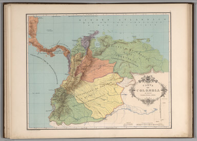 |
Atlas geografico e historico de la Republica de Colombia (Antigua Nueva Granada), 1889
Codazzi, Agustín; Paz, Manuel María, Paris
Geographical and historical atlas of the Republic of Colombia (Antigua New Granada), which comprises the Republics of Venezuela and Ecuador, under the general geographic works of Agustin Codazzi. Cartography by Manuel M. Paz, and explanatory text written by Dr. Felipe Perez Member of the Geographical Society of Paris. Maps are full color. Very rare example of the second atlas ever dedicated to Colombia. The first was Restrepo’s Atlas that came with his 10 volume Historia de la Revolucion de la Republica de Colombia (see our 5597.000 for the atlas volume). View Atlas
|
 |
Ordnance Survey of Scotland: 131 Sheets, Scale 1 inch to a mile, 1898
Ordnance Survey of Scotland; Farquharson, JC., London, Southampton
The one-inch first edition of Scotland was based on larger scale surveys of 1843-1878. This set is the second edition, produced from first national revision of 1894-95. Edward Stanford assembled the 131 sheets into three bound volumes with title page, index, and extensive and beautiful coloring. Fair Isle was not revised, and thus sheet 123 was not issued in this edition, but is present, as a first edition sheet. A national revision of 1894-1895 was published in 1896-1898, as second edition, while a further revision of 1901-1910, published 1903-1912, was known as the 'Third Edition. This edition bound in 3 volumes, each with index map mounted inside front cover. Outline hand colored. The coloring has green for parks and estates, blue for inland water and coasts, red for buff roads and railways, and different pastel colors for county boundaries. View Maps
|
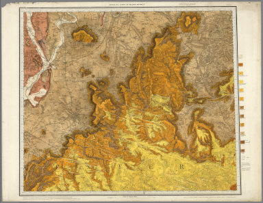 |
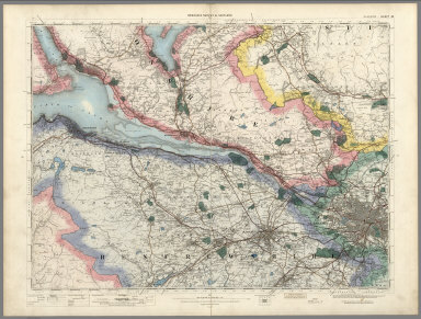
Ordnance Survey of Great Britain. Geological Survey of Great Britain. Old Series, One-Inch Map with National Grid, England and Wales, 1899
Geological Survey of Great Britain and Ireland; Great Britain, Ordnance Survey Office, Southampton
This geological map series of England and Wales was published beginning in 1834 and is shown on the Ordnance Survey Old Series of One Inch to the Mile base maps (see our 6916.000). A total of 262 sheets were published through 1898: 52 full sheets, 2 half sheets, and 208 quarter sheets. Our current set has 215 sheets; we have put online the missing 47 sheets with images from the collection of the British Geological Survey, although we will be replacing those over time as we acquire the missing sheets. The geological coloring of these maps was done by hand painting well into the 20th century - at a time when most geological maps were produced by color lithography. The resulting color is rich and produces images of great scientific and artistic clarity. View Maps
|
 |
Twenty-first Annual Report of the United States Geological Survey to the Secretary of the Interior. 1899-1900. Charles D. Walcott, Director. In Seven Parts. Henry Gannett, Chief of Division. Washington. Government Printing Office. Part V - Forest Reserves, 1900
USGS (U.S. Geological Survey); Walcott, Charles D., Washington, D.C.
Maps show the extent of U.S. Forest Reserves at the end of the 19th century. Includes 711 xi pages, 39 maps. Accompanying Papers: Lewis and Clarke Forest Reserve, Montana, by H.B, Ayers, pages 27-80. Mount Rainier Forest Reserve, Washington, by Fred G. Plummer, pages 81-144. Olympic Forest Reserve, Washington, by Arthur Dodwell, pages 145-208. Cascade Range Forest Reserve, by John B. Leiberg, pages 209-498. Stanislaus and Lake Tahoe Forest Reserve, by George B. Sudworth, pages 499-562. Classification of Lands, by Henry Gannett and others, pages 563-602. Woodland of Indian Territory, by C.H. Fitch, pages 603-672. Timber Conditions of the Pine Region of Minnesota, by H.B.Ayers, pages 673-690. View Report and Maps
|
 |
Deutsche Seewarte. Atlantischer Ozean. Ein atlas von 39 karten, die physikalischen verhaltnisse und die verkehrs-strassen darstellend, mit einer erlauternden einleitung und als beilage zum segelhandbuch fur den Atlantischen Ozean. Zweite Auflage, 1902
Deutsche Seewarte, Hamburg
Second edition, 39 color maps and charts. The atlas is an analysis of the Atlantic Ocean, showing specific weight of sea water, ocean currents, water temperature at various depths and seasons, air temperature and pressure above the ocean, frequency of winds and storms by season. With vi, 9, pages of contents, forward by Dr. von Neumayer, Die Direktion der Deutschen Seewarte, and explanatory remarks to the individual maps. View Maps
|
 |
Ordnance Survey Revised Map of England, Wales, and Scotland on the Scale of Four Miles to the Inch, 1902
Ordnance Survey Office, Southampton
Two sets of maps together: England and Wales; Scotland; each with separate index maps for each area. First edition, outline edition, published 1900-1902. Several sheets extended to include small adjacent areas. View Maps
|
 |
Ordnance Survey Ireland Quarter-inch Series, 1904
Ireland. Ordnance Survey, Dublin
Published 1903-1904 on 16 sheets. 1st edition. Outline edition with blue coastal tint and main roads brown. This set has trimmed margins and each sheet is dissected into ten panels and mounted on linen by bookseller Edward Stanford. Presented folded with covers on back of each sheet. Crisp clean set, virtually unused. Shows individual buildings in rural areas but no relief. View Maps
|
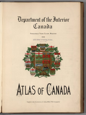 |
Department of the Interior, Canada. Honorable Frank Oliver, Minister, 1906. Atlas of Canada (with) Department of the Interior Canada. Honourable W.J.Roche, Minister 1915. Atlas Of Canada. Revised and enlarged edition.
White, James; Chalifour, J.E.; Canada. Department of Interior, Ottowa
The 1906 first edition and the 1915 second edition. The Atlas of Canada, first edition published by the Department of the Interior in 1906, was one of the world's first national atlases. A second edition similar in style and content was published in 1915, both editions, featuring thematic maps dealing with Canada's geology, communications, natural resources, population, economic activities, transportation, as well as maps of principal cities. During this period, a major part of Canada's growth was due to the great influx of immigrants into Canada, many of them coming to open up the farmlands of the Prairies. Consequently, the first two editions of the Atlas of Canada reflect a particular interest in transportation and communications and devote a significant amount of space to mapping the composition and density of the population. View Atlases
|
 |
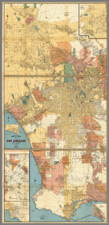
Baist's Real Estate Atlas of Surveys of Los Angeles, Cal. Complete in One Volume, 1921
Baist, G.W., Philadelphia
An extremely detailed atlas similar to the Sanborn insurance maps; updates pasted in and on versos of some original map plates (dates of updates not known). Full color key is explained in legends on plates. Baist first published the Los Angeles atlas in 1905 with 26 maps plus index; subsequent editions appeared in 1910 (34 maps plus index), 1914 (44 maps plus index), 1921 (this copy, 49 maps plus index) and 1923 (49 maps plus index). The period after World War I was a time of real estate expansion and development, hence the many updates in this 1921 edition. The 1921 edition is the first edition to include the five San Fernando Valley maps. View Atlas
|
 |
Bartholomew's 4 Miles to the Inch Road Map of England & Wales in Twelve Sheets, 1921
John Bartholomew and Son, Edinburgh
Published 1918-1921 on 12 sheets. Has blue coastal tint and main roads red. Relief shown in hachures. Forests in green. Includes mileages, railways and stations, and county boundaries. Each map is folded (not dissected) into 32 panels and mounted on linen. View Maps
|
 |
Ordnance Survey of England and Wales. Popular Edition One-Inch Map, 1923
Ordnance Survey Office; Great Britain, Ordnance Survey, Southampton
Set of 146 sheets of which 144 sheets are flat on paper, 2 sheets (#145 and #146) mounted on linen and folded with covers. Legend on each sheet. Full color. Relief shown by contours. Comparing this set to our later "New Popular One-Inch Map with National Grid, England and Wales" of 1947 (see our 6917.000) one can see many changes both in the urban areas expanding and in the adoption by the Ordnance Survey of the National Grid. View Maps
|
 |
Ordnance Survey of Great Britain. Quarter-inch to One Mile. Third Edition, 1924
Great Britain. Ordnance Survey, Southampton
Map sheets are undissected but mounted on linen and folded into 32 panels. The sheets in this set have publication dates of 1919-1921 and reprint dates (for some) of 1922-1924, see Note on each sheet. Superb condition. Full color. Relief shown in attractive hypsometric tinting; contour intervals differ above 1,000 feet elevation. Many cultural and natural features shown. Maps are noted as "Published by Colonel Sir Charles Close..." View Maps
|
 |
Atlas of the Historical Geography of the United States. By Charles O. Paullin, Carnegie Institution of Washington. Edited by John K. Wright, Librarian, American Geographical Society of New York, 1932
Paullin, Charles O.; Wright, John K., New York, Washington, D.C.
This is one of the best historical atlases published in the early 20th century. It combines history and geography, facsimile historical maps and new historical maps, and incorporates time and statistics in imaginative map visualizations. The text and maps are based upon information supplied by prominent authorities on the various subjects. The quality of the contents is also reflected by the authoritative map publishers. Numerous facsimile maps are included. All text pages are shown in one large composite image. View Atlas
|
 |
California Highway Transportation Survey, 1934
California Division of Highways, Sacramento
A fascinating group of transportation maps showing traffic at the state, county, and city levels in the early 1930's in California. Primary report of 130 pages softbound but in rigid library binding. Appendix B in same format. Appendix B is Tabulation of Field Count by Cities and Counties. Atlas issued as Appendix A. Base maps copyright by Rand McNally & Company under title Complete Map of California. View Maps
|
 |
Thomas Bros. Recreational and Statistical Atlas, California, 1938
Thomas Bros.; Thomas Brothers, Oakland
Title is from the cover. There is no title page. Date is estimated. 1st "road" atlas of California. According to Tom Lennon of Thomas Brothers Map Co. in Los Angeles, this atlas is rare; they have five copies of it in their L.A. office, and he has never seen any other copies. He thinks the original issue was very small. Bancroft has no copies, but does have a copy of Thomas Bros. Atlas of Western Cities and Towns (no date but library note says acquired in 1937) which duplicates some of this atlas's material (smaller S.F. map, larger color Pasadena map) and adds more on cities in adjoining western states. Lennon said this atlas was "a put together thing by George Thomas." He also said there was an Atlas of the San Francisco Bay Area by the company, produced for the World's Fair of 1936. Maps are printed with and without color. Bound with three illustrated promotional pamphlets advertising various scenic areas of California. Includes a large six sheet map of Los Angeles in full color. View Atlas
|
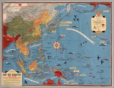 |
Dated Events. On To Tokyo. Map of the Pacific and the Far East (with) Dated events, World War map, by Stanley Turner A.R.C.A., 1944 and 1942
Turner, Stanley; Petersen, C.C., Toronto
Two World War II maps by Stanley Turner. The map centered on Europe shows naval bases; cities blitzed by Nazis Luftwaffe; industries bombed by R.A.F; countries under British control; countries conquered by the Nazis; neutral countries. The map centered on the Pacific has a note below title: "With this invasion map you will be able to follow the progress of the Allied armies on their way to smash Japan ..." Each map went through many editions as the war progressed. Both maps are from the collection of John Oram. View Maps
|
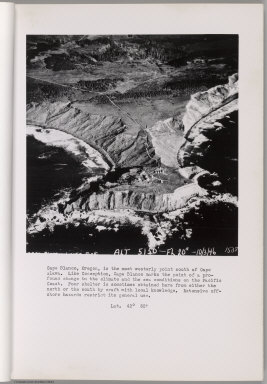 |
Preliminary Report on Harbors, Havens, and Anchorages of the Pacific Coast from San Francisco to the Straits of Juan de Fuca, 1946
Isaacs, John D.; Bascom, Berkeley
Initial issue October 31, 1946, revised December 31, 1946. Wave Project Laboratory Memorandum HE-116-225. Fluid Mechanics Laboratory. Navy Department Bureau of Ships, Contract N0bs2490. Photographs taken by Utility Squadron Two, Moffett Field, California. This report is prepared as a aerial photographic guide to the recognized and unimportant harbors, havens, and anchorages. The author personally negotiated every passable entrance in a small craft (with the exception of Bolinas and Mendocino Bay) and has sheltered in the havens. View Aerial Photos
|
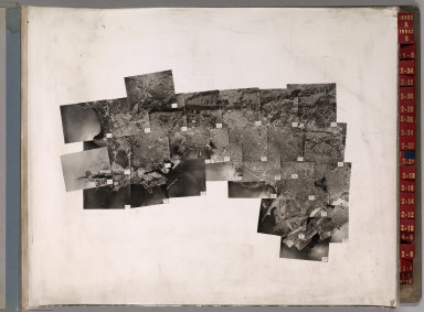 |
Key System Transit Lines: Aerial System Maps (Alameda and Contra Costa Counties, California), 1947
Key System Transit Lines (Calif.); Sunderland, Clyde H., Oakland
Large volume of bound aerial photographs with colored tape showing the Key System train, tram, and bus routes. (Formerly) Restricted. Two index sheets and 62 enlargements of western Alameda and Contra Costa Counties. Black and white. View Atlas
|
 |
Ordnance Survey of Great Britain. New Popular One-Inch Map with National Grid, England and Wales, 1947
Great Britain. Ordnance Survey, Southampton
Series published 1940-1947, but omitting the war years 1941-1944. Complete set of published 115 maps in New Popular Series. The discontinuous numbering system begins with Sheet No. 64. Bound in 4 large volumes in which each sheet has been mounted on linen. In addition to relief shown as contours, numerous physical and cultural features, the maps show in great detail the entire railroad system of England and Wales when it was most extensive. Added across the bottom of each digital image are three parts from the individual covers of a folded (dissected) version of another copy of the map set. The three added parts are the folded cover with a miniature of the area covered, an explanation of the national grid and other map features, and an index map showing the sheet location. View Atlas
|
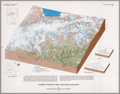 |
Atlas of Oblique Maps, A Collection of Landform Portrayals of Selected Areas of the World, 1988
U.S. Geological Survey; Alpha, Tau Rho, Reston, Virginia
This folio comprises scale-accurate, obliquely viewed maps compiled from 1961-1986 that portray the physiography of selected areas of the ocean floor and continents around the world. These oblique views of landscapes draw upon the techniques of Armin K. Lobeck, Erwin J. Raisz, and Philip B. King. View Atlas
|