 |
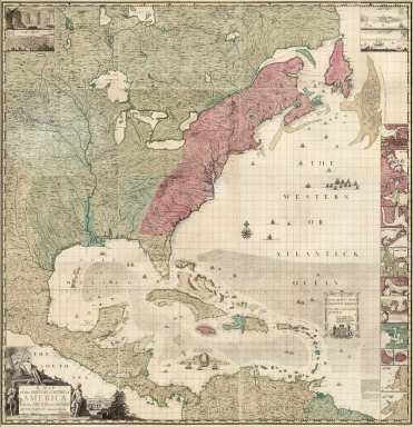
A Map of the British Empire in America with the French and Spanish Settlements adjacent thereto, 1746
Popple, Henry, London
This is a full color atlas edition of Popple's twenty sheet map. This edition was sold by Stephen Austin Bookseller and Thomas Willdey in London. Compare this later edition (1746) with our first edition (1733) atlas. View Atlas and BookReader
|
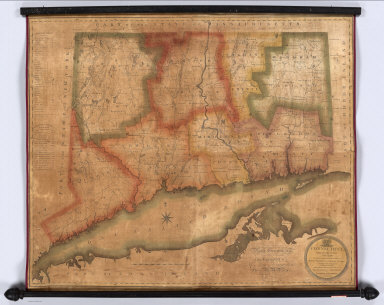 |
22 Wall Maps, 1813 - 1882
Various Authors
A group of wall maps ranging from Warren and Gillet's Connecticut 1813, to Berghaus' World on Mercator's Projection, 1882. View Maps
|
 |
Carey's General Atlas, 1818
Carey, Mathew, Philadelphia
Third and last edition of Carey's General Atlas. There is a Preface to the third edition, dated June 18, 1818. View Atlas
|
 |
2 Maps of the United States of Nth. America, Map of Mexico and Louisiana, 1812 - 1820
Tardieu, P.F., Paris
Three multi-sheet maps by the French cartographer P.F. Tardieu: United States of North America 1812 and 1820, and Mexico and Louisiana, 1820.Tardieu used Arrowsmith's maps as his sources, but added much new information and employed an elegant style of engraving. View Maps
View all Tardieu maps of North America.
|
 |
Mappe Monde en deux Hemispheres presentant L'Etat Acuel de La Geographie, 1820
Brue, A.H., 1820
Large map of the world in four sheets plus a title sheet. Includes "Avertissement" commenting on the accuracy of the map, and "Observation" commenting on the projection referencing the 1794 map by Arrowsmith. View Map
|
 |
A New General Atlas, 1824
Finley, Anthony, Philadelphia
The first edition of this important American atlas. Finley produced many editions of this atlas up to 1834. Most of the atlas maps were also issued as pocket maps. At the end of the atlas there is an advertisement for Finley's Map of the United States. View Atlas
|
 |
3 Composite Maps of North and South America, 1827
Vanermaelen, Phillip, Paris
These three composite maps of Vandermaelen's 119 sheets of North and South America were created by georeferncing the sheets in GIS, using a polyconic projection similar to Vandermaelen's projection, then combining the sheets using the program Global Mapper which also trimmed the sheets to allow compositing. The result gives a view of Vandermaelen's sheets that is not possible with the atlas presentation but is similar to the large 7.75 meter diameter globe that Vandermaelen created from the atlas sheets and displayed in Brussels. View Maps
View Entire Vandermaelen World Atlas 1827
|
 |
Atlas of Physical Geography, 1850
Petermann, Augustus; Milner, Thomas, London
From the full title: "With Descriptive Letter-Press, Embracing A General View Of The Physical Phenomena Of The Globe. By The Rev. Thomas Milner, M.A., F.R.G.S. ... Illustrated by One Hundred and Thirty Vignettes on Wood." View Atlas and BookReader
|
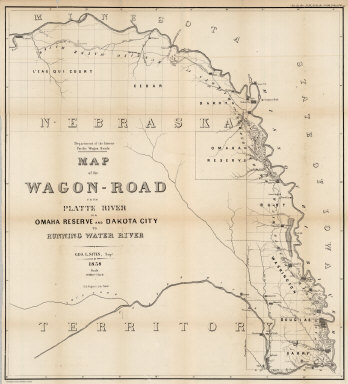 |
Reports upon the Pacific Wagon Roads, 1859
Campbell, Albert, Philadelphia
Six maps show various wagon roads developed by the U.S. government in the late 1850"s: a map of the route from Fort Ridgely in Minnesota to Fort Lookout on the western side of the Missouri River in Nebraska; two maps showing the Western Division of the Fort Kearney South Pass and Honey Lake Road; two maps that begin in El Paso, Texas and continue through Arizona, north of Tucson and San Xavier del Bac to the Pimo Villages on the Gila River; and a map of the Wagon-Road from Platte River via Omaha Reserve and Dakota City to Running Water River, along the Missouri River. View Maps
|
 |
Johnson's New Illustrated (Steel Plate) Family Atlas, 1865
Johnson, A.J., New York
Late 1865 edition. From Title Page: "The New Plates, Copyrighted by A. J. Johnson, are made exclusively for Johnson's New Illustrated Family Atlas. Others are the same as Used in Colton's General Atlas." Adds a double page map of "Nebraska, Dakota, Idaho and Montana" that also shows Wyoming - this is a newly drawn map. This is the first appearance of Wyoming on a map (Resor). View Atlas
|
 |
Report Upon The Removal of Blossom Rock, San Francisco Harbor, 1870
Williamson, R.S.; Heuer, W.H., Washington, D.C.
Story of the demolition of Blossom Rock, a maritime navigational hazard in San Francisco Bay midway between Alcatraz Island and Yerba Buena Island. View Book and BookReader
|
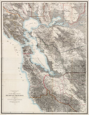 |
Map Of The Region Adjacent To The Bay Of San Francisco, 1873
Hoffmann, Charles F.; Whitney, J.D.; Geological Survey of California, New York
An important detailed map of the San Francisco bay area by the Geographical Survey of California under J.D. Whitney. Julius Bien of New York did the engraving and printing. C.F. Hoffmann was the prinicpal topographer; 1st issue was 1867. No mention of the 1873 date in any references. Two sheets printed on thin paper, folded into green covers. Outline color. View Map
|
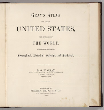 |
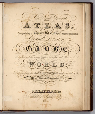
Gray's Atlas Of The United States, 1874
Gray, Ormando Willis, Philadelphia
Late 1874 issue - the extra double page Oregon, California and Nevada map is undated and the inset map of the Bay Area shows a new railroad from Benicia, and other railroads projected. However, we cannot find any other changes from the early 1874 issue. This edition was made for the California market, with the extra map of Sacramento and the map of Oregon, California and Nevada. View Atlas
|
 |
The National Atlas. Containing Elaborate Topographical Maps Of The United States And The Dominion of Canada, 1878
Gray, Ormando Willis, Philadelphia
First edition was 1875. The maps here are identical to our 1878 Gray's Atlas of the United States (although substantially changed from the 1874 edition), except that this copy has 17 large scale maps of Virginia Cities in the rear with a "Professional Directory of Patrons. Virginia." It is a mystery why Gray used two different titles for essentially the same atlas. View Atlas
|
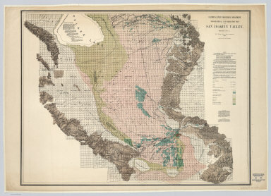 |
35 Irrigation Maps San Joaquin Valley and Southern California, 1880 - 1888
Hall, Wm. Ham. (William Hammond); California State Engineering Department, Sacramento
The sheets show the areas of land that can be practically irrigated in the San Joaquin portion of the Central Valley and parts of Southern California. Classifies lands into several categories. Printed in full color. Mounted on linen. Relief depicted by contour lines in valley areas, and by hachures in the hills and mountains. 33 of the maps were scanned from the collection of the Water Resources Center Archives, University of California Library. View Maps
|
 |
Johnson's New Illustrated Family Atlas Of The World, 1886
Johnson, A.J., New York
A very late edition of this atlas that was first issued in 1860, 1887 is the last edition that we have, although Phillips shows 1885 as the last edition. Most of the maps have been updated to show changes in the American west, railroad development, and geographic discoveries. View Atlas
|
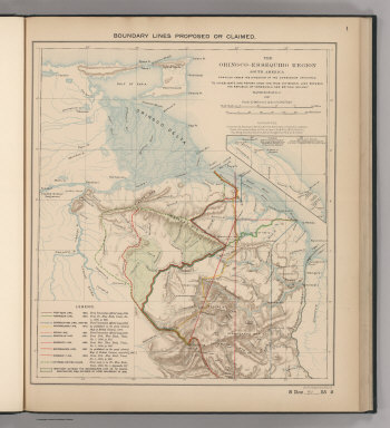 |
Report Upon The True Divisional Line Between The Republic Of Venezuela And British Guiana, 1897
Venezuela-British Guiana Boundary Commission, Washington, D.C.
Reproductions of maps from 1534 to 1875. On cover: Venezuelan Boundary Commission Report. 1898. Atlas (vol. 4 indicated on half title). With printed color. The American resolution under the auspices of the Monroe Doctrine, and as illustrated by this atlas, of the dispute between Britain and Venezuela, largely followed the the route (favoring Britain) of the Schomburgk Line, the name given to a survey line made in 1835 by Robert Hermann Schomburgk (1804-1865). Venezuela periodically contests its validity. View Atlas
|
 |
(British Atlas, U.S. Atlas, Atlas of Award). Alaskan Boundary Tribunal, 1904
Alaskan Boundary Tribunal, Washington D.C.
Three volumes, with excellent facsimiles of historic maps that support the sides in the dispute. With printed color. "Many of these maps have been reduced in scale to bring them within the limits of this atlas." Many maps also only show the portion of the original applicable to the Alaska/Canada boundary. View Atlas
|
 |
The Coal Resources Of The World. Atlas, 1913
Campbell, Marius R., Toronto
Shows coal resources throughout the world in the early 20th century. Elegant color printing. This copy has only 45 of 48 maps (missing Map Nos. 24-26, which cover portions of Canada in detail). View Atlas
|
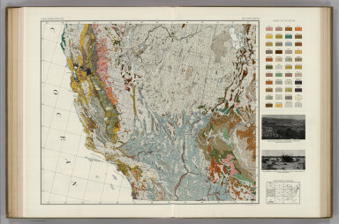 |
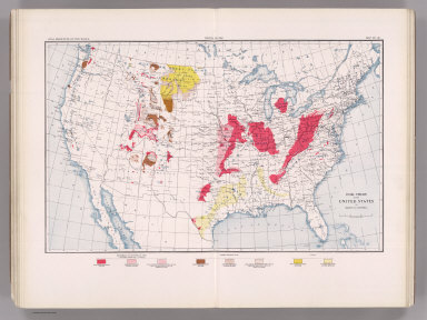
Atlas of American Agriculture, 1936
Kincer, Joseph Burton, Washington D.C.
A spectacular color atlas of the United States exhibiting great detail in hundreds of maps, graphs, tables, and text on the full range of agricultural topics and subtopics. Bound into a single volume here, it consists of several parts often found as separates: Land Relief; Climate: Temperature, Sunshine, and Wind; Climate: Frost and the Growing Season; Climate: Precipitation and Humidity; Soils; and Natural Vegetation: Grassland and Desert Shrub, Forests. View Atlas and BookReader
|
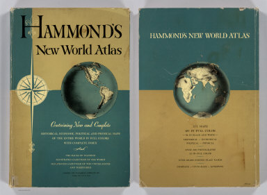 |
Hammond's New World Atlas. Containing New and Complete Historical, Economic, Political and Physical Maps of the Entire World in Full Colors, 1948
Hammond, C.S., Garden City, New York
With 277 maps, shows the new political configuration of the world at the end of World War II. Includes an Illustrated Gazetteer of the United States and Territories. View Atlas
|
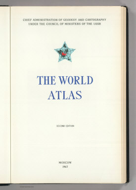 |
The World Atlas. Second Edition, 1967
USSR (Union of Soviet Socialist Republics), Moscow
This second edition of the Atlas of the World (1st edition in 1954) has fewer maps of the USSR on account of the interim publication of the "Atlas of the USSR", three fewer historical maps due to then impending publication of the "Historical Atlas of the World", and many new maps and revisions. The Atlas was considered accurate in terms of contemporary knowledge of the ocean floors. This edition also uses both the Russian and the Roman alphabets - making it comprehensible to a much broader range of readers. "The second edition of the World Atlas is issued at a time when all progressive people of the globe are celebrating the 50th anniversary of the Great October socialist revolution." Mapped in attractive full color with tints for elevation and sea depth values. Relief shading is sometimes used to contribute to realism. Scales generally in regular increments (two or multiples of two); urban vicinity maps typically at 1:250,000 facilitating the comparison of the sizes of major cities around the world. View Atlas
|
 |
Pergamon World Atlas, 1968
Polish Army Topography Service, Oxford
This is the English edition of the Polish Atlas Swiata. This massive atlas (weighing nearly 5.5 kilograms and containing 48 square meters of maps) is of high cartographic and aesthetic quality, and provides a rich assortment of thematic (over 400) as well as hundreds of physical and political maps. Includes pictures of the flag and a synopsis for each country. Rich use of symbolism creatively conveys the data in a clear manner. View Atlas
|
Thanks for making your wonderful collection available to the public. The classical maps you have scanned are especially useful to me. I would love to see the following two very important (and rare) classical atlases if your have them in your collection:
1. “An Atlas of ancient geography, biblical & classical: to illustrate the Dictionary of the Bible and the classical dictionaries” / edited by William Smith and George Grove London : Murray, 1875.
2. “Atlas antiquus, sacer, ecclesiasticus et profanus; in quo Terrae Sanctae variae divisiones, dioecesium patriarchalium & episcopalium limites, orbisque universus antiquus, prout erat olim excultus & divisus oculis subjiciuntur; collectus ex tabulis geographicis Nic. Sansonis, ejus filiorum, aliorumque celebrium geographorum” By Jean Le Clerc, Published: Amstelodami, J. Cóvens & C. Mortier, ca. 1725
Both of these were praised in their time as being the most comprehensive and complete atlases dealing with classical history.
Thank you so much for your consideration.