- Featured Maps
- July 11, 2011
First Atlas of Russia, Published in 1745
The first Atlas of Russia from 1745 has been added to the online collection. It was published by the Academy of Sciences in St. Petersburg, Russia, expanding on the cartographic work done previously by Russian cartographer Ivan K. Kirilov. Joseph Nicolas de L'Isle, the great French astronomer, was invited by the Academy of Sciences in 1726 to come to St. Petersburg to oversee the production of the atlas, although his role and contributions to the atlas are disputed by historians. The atlas maps present the first complete national survey of the entire country at uniform scales for European and Asiatic Russia. Alexei Postnikov, author of "Russia in Maps," says this atlas "brings together all the geographical discoveries of the early 18th century to give a fuller picture of the entire Empire than shown in the so-called Kirilov atlas. The maps were mostly based on instrumental surveys, geographical descriptions and maps compiled by the Petrine geologists and their successors." Normally the atlas includes 20 maps; this copy is special in adding an additional 17 maps and 2 text pages, including plans of St. Petersburg and Moscow (similar to a copies at the Library of Congress, Phillips 4060 and Phillips 3109). The maps have titles in German and Latin; place names are in Russian and Latin alphabet. The text of cartouches is in Latin. The atlas was also issued with French and Russian title pages and text, with the title Atlas Russicus and Atlas Rossiiskoi. This copy contains 7 pages of text with descriptions of the maps and explanations of geographical names and symbols used in German, Russian, French and Latin, a general map of the Russian empire, 13 maps of European Russia at a uniform scale of 1:1,470,000 (35 versts to one inch, 1 verst equals 3,500 feet), and 6 maps of Siberia at a uniform scale of 1:3,444,000 (82 versts to one inch). Bound in at end of the atlas are 19 additional text and maps of Russian territories, plans from the Russo-Turkish war of 1736, engravings of military fortifications, maps of Ladoga Lake, environs of St. Petersburg, Kronstadt and the Gulf of Finland. Maps are colored in outline, with some maps in full color. We have added 2 composite images of all 13 maps of European Russia and all 6 maps of Siberia. The atlas was printed in September 1745 in St. Petersburg. View the atlas.
The general map of the Russian Empire extends from the Baltic to the Pacific Ocean at a scale of 1: 9,030,000:

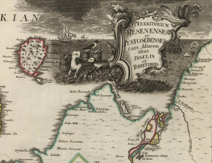
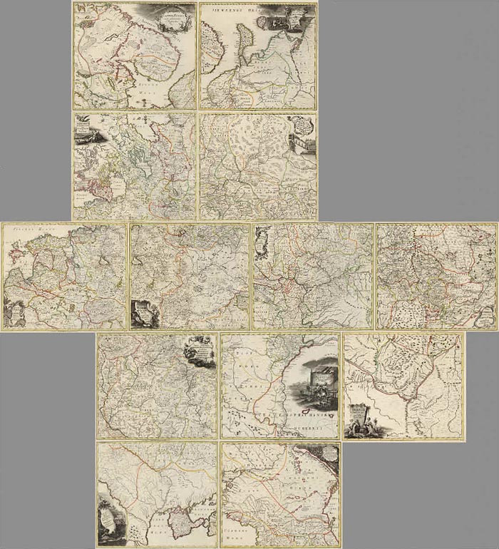
Each of the 13 maps of European Russia are drawn at a scale of 1:1,470,00 or 35 versts to the inch. Many have decorative cartouches:
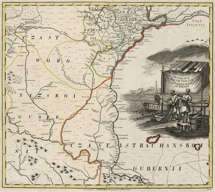
This map shows a long portion of the Volga River:
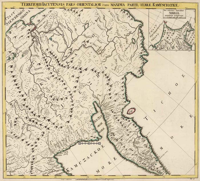
The 6 maps of Asiatic Russia (Siberia) are at a scale of 1: 3,444,000 or 82 versts to the inch:
A Legend (in German) on the last page of text describes the various symbols used on the maps:

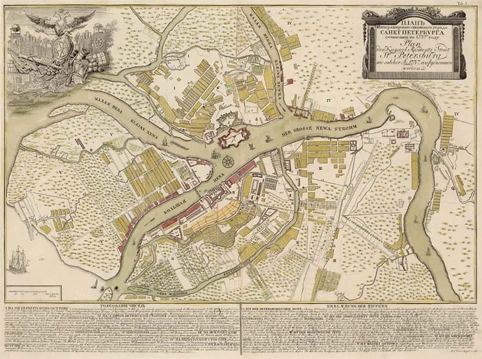
This atlas is unusual in having an additional 17 maps and 2 indexes added to the 20 maps that usually comprise the atlas. Among the 17 extra maps is a plan of St. Petersburg from 1737:
Also included is a map showing the Gulf of Finland between St. Petersburg and the island of Cronstad, and the outlet of the Neva River in St. Petersburg, 1741:

And a plan of Moscow from 1739:

A map of the Caspian Sea from 1728:

We have created 2 composite images, 1 of the 13 maps of European Russia and 1 of the 6 maps of Asiatic Russia or Siberia. Here is the composite image of the European Russia Maps:
And here is the composite image of the Siberian maps:

4 languages are used in the atlas: Russian, German, Latin and French (although French is used primarily in the map cartouches and notes). The atlas title page and text pages were printed in 3 versions: Russian, French/Latin, and German. The title page and 6 pages of text describing the maps and Russian geographical terms in this copy are the German version:
 |
 |


The index page for the map of Moscow is in Russian:

The text page describing the some of the Turkish Russian War battles is in Latin, Russian, and German:

Considering the vastness of the Russian Empire, this atlas was a remarkable achievement. While not accurate by today's standards, at the time it was a significant improvement in cartographic representation of the country, and it was certainly then the largest part of the globe mapped systematically at a uniform scale, using the best science of the day.
6 Comments on First Atlas of Russia, Published in 1745
Albert Struijk
on July 29, 2011 at 3:49AM wrote:
What a fantastic atlas. Is there a facsimile of it?
David Rumsey
on July 29, 2011 at 1:45PM wrote:
We are not aware of a facsimile of this atlas.
camilo cadena agamez
on January 17, 2013 at 7:53PM wrote:
que chimba de mapas
Walter
on December 15, 2013 at 11:25AM wrote:
Awesome map! I'm now on the search for my family's ancestral region near Novgorod if it's on the map during this period.
Juan Carlos Scheigel Huck
on August 22, 2022 at 6:19AM wrote:
Excelente material, muchas gracias por hacerlo público, Felicitaciones !!!
Increible Coleccion Cartografica... Es toda una obra de Arte... Gracias por el aporte...Desde Costa Rica. America Central.