- Recent Additions
- November 20, 2009
November 20, 2009 - 1,238 New Maps Added
The following are highlights from 1,238 New Maps and Images added to the David Rumsey Collection. Included are John Cary's comprehensive road map of England and Wales from 1794 (plus a composite image joining all 81 sheets), John Wilson's important Map of South Carolina, 1822, Pick's time-line historical chart from 1858, geological and oil maps of Pennsylvania, 2 editions of Rand McNally's Business Atlas, 3 editions of Johnston's Royal Atlas, the atlas edition of Viele's map of New York City from 1874, and more. All titles may be found by clicking on the View links below. Or click here to view all 1,238 new maps.
|
|
Cary's New Map of England and Wales, With Part of Scotland, 1794 The large composite map joining all sheets may also be viewed in Google Earth |
 |
Map of the United States and British Provinces of Upper and Lower Canada, 1816 |
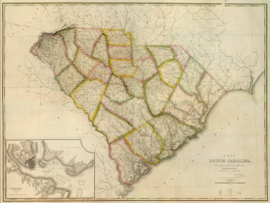 |
Map Of South Carolina, 1822 |
 |
Western Hemisphere; Eastern Hemisphere, 1825 |
 |
An Atlas of Ancient Geography, 1826 Tanner, Henry, Philadelphia 16 maps. Maps in full color. Maps are divided into three categories: Geographia Sacra, Ecclesiastica, and Antiqua. View Atlas |
 |
Atlas Universel Pour servir a l'Etude De La Geographie Et De L'Histoire Anciennes et Modernes, 1827 Vivien de St Martin, L., Paris 48 maps. First edition. The maps are well done, slightly smaller than the contemporary Brue and Lapie maps (except in the case of the double sheet maps), Nonetheless, the entire atlas achieves a beautiful overall effect. View Atlas |
 |
Atlas Universel d'Histoire et de Geographie Anciennes et Modernes, 1835 Duval, Henri, Paris 40 maps and diagrams. A unusual school atlas with hand lettered lithographed plates, each signed by Duval. Includes thematic maps on the natural world, astronomy, geology, and other subjects. View Atlas |
 |
Sharpe's Corresponding Atlas, 1849 Sharpe, J.; Lowry, J.W., London 54 maps. An atlas that attempts to use projection to aid understanding of world geography. In the preface, Sharp explains the use of only four scales (plus one for Switzerland) among the 54 maps, done with the intent to facilitate equitable comparison and comprehension of world regions. View Atlas |
 |
Black's Atlas Of North America, 1854 Black, Adam & Charles; Bartholomew, John, Edinburgh 20 maps. All maps are by John Bartholomew. This is the first use of printed color by Black and Bartholomew. A fine atlas, scarce, and especially interesting when compared to another similar but more elaborate U.K. contemporary publication on North America, Rogers and Johnston's Atlas of the United States, 1857. View Atlas |
 |
General Atlas Of The World, 1854 Black, Adam & Charles; Hall, Sidney; Hughes, William, Edinburgh 70 maps. This edition represents a significant change of maps for Black; Phillips lists the entire contents, which he rarely does for an atlas of this period, indicating his view of its importance. The map of Mexico includes the California Gold Regions colored in gold. View Atlas |
 |
Geological Map Of The State Of Pennsylvania, 1858 Rogers, Henry Darwin, Edinburgh This large map was intended to accompany the text volumes of the Final Report on the First Geological Survey of Pennsylvania, 1858. The map is fully colored to show geological formations, and has nine sections below the map. W. & A.K. Johnston engraved the map, further evidence of their collaboration with Rogers in addition to the 1857 Atlas of the United States. View Map |
 |
Tableau De L'Histoire Universelle depuis la Creation jusqu'a ce jour, 1858 Pick, Eug,, Paris Date is estimated. This is a timeline historical map, The map has vignettes of people, buildings, historical scenes and important places in the history of the world. It begins with Adam and Eve and the Garden of Eden (dated as 4963 BC) and shows the passage of history as the flows of various rivers, ending in the time the map was made, 1858. The United States is given only brief mention as a branch of the river representing Great Britain. Full color. Dissected into 9 sections and edged in white cloth. View Map |
 |
Map of the Centre Oil Region From Oil City To Parkers Landing , 1871 Wrigley, Henry E.., Titusville A unique, very large scale map of the center oil region (the largest scale we have seen) made by the photographic process. Henry Wrigley was a civil engineer active in the oil region who self published a series of five oil region maps by the photographic process; on the map he states "By this means (photography) every one can be kept constantly advised of the progress of all developments and possess the information desired at the time he most needs it." View Map |
 |
Topographical Atlas Of The City Of New York Including The Annexed Territory, 1874 Viele, Egbert L., New York Larger version of Viele's 1865 New York Map in Atlas form, in original printed tan paper wraps reading "Topographical Atlas Of The City Of New York. By Egbert L. Viele. 1874," with the sheets unfolded. According to Stokes, this edition was prepared from new surveys by Eugene Quackenbush. On five sheets; full color indicating meadow, marsh, and made lands. View Atlas |
 |
The Royal Atlas Of Modern Geography, 1879 Johnston, Alexander Keith, Edinburgh and London 51 maps. An updated edition of an atlas that was first published in 1861 and continued publication into the early 20th century. View Atlas |
 |
Atlas Universel de Geographie Moderne. Physique, Politique, Historique, Industriel, Commercial et Militaire, 1882 Jouvet et Cie., Paris 40 maps. A thematic and physical atlas with well executed maps. View Atlas |
 |
Mitchell's New General Atlas, Containing Maps Of The Various Countries Of The World, Plans Of Cities, Etc., 1886 Mitchell, Samuel Augustus Jr., Philadelphia 73 maps. At this late date in the run of Mitchell Atlases, William Bradley of Philadelphia was the publisher with Mitchell's own role no longer clear. View Atlas |
 |
Mitchell's New General Atlas, Containing Maps Of The Various Countries Of The World, Plans Of Cities, Etc., 1886 Mitchell, Samuel Augustus Jr., Philadelphia 68 maps. Association copy per W. H. Gamble (fl. 1867-1887), Geographer, author of handwritten transmittal to Mrs. Emmie Johnson, tipped into lining paper, along with Gamble's card. Gamble made many of the maps in the Mitchell atlases. Although the date is the same as the 1886 copy above, there are many changes to the maps throughout the atlas. View Atlas |
 |
Rand McNally & Co.'s Enlarged Business Atlas And Shippers' Guide , 1889 Rand McNally and Company., Chicago 93 maps. 1st edition in this format was 1885. This is the 18th edition. With printed color. Extensive coverage of railroads. Includes all text pages which have an extensive index of places, railroads, county seats, and more. View Atlas |
 |
The Royal Atlas Of Modern Geography, 1893 Johnston, Alexander Keith, Edinburgh and London 54 maps. Another edition of Johnston's world atlas, all maps now in printed color. View Atlas |
 |
Rand - McNally Official Railway Map Of The Pacific Coast States Including Territory East To Denver, 1901
Rand McNally and Company, Chicago A large scale map of the American west from central Colorado to the coast. Shows all railroads in operation, topographical features and public surveys. It is copyrighted in 1901 with the present title (indicating that it may be the first edition in this form) and in 1893 and 1898 as "Rand, McNally & Co.'s Standard Map of the United States" (suggesting that it may have been derived from a larger map of the entire U.S.). View Map |
 |
Rand McNally & Co.'s Enlarged Business Atlas And Shippers' Guide, 1903 Rand McNally and Company, Chicago 102 maps. This is the 33rd edition. Maps change from the 1890's editions - they are now similar to the Large Indexed Atlas. Complete with all text pages and indexes of places, railroads, and more. View Atlas |
 |
Johnston's Royal Atlas Of Modern Geography, 1912 W. & A.K. Johnston, Edinburgh and London 54 maps. Preface by G.H. Johnston. Alexander Keith Johnston's name is dropped from the title page. Maps are printed in outline color with the exception of the full color North and South Polar Charts. This is a very late edition of the Royal Atlas, the final year of publication shown in Phillips being 1919. View Atlas |
 |
Campfire Rings in the Backcountry of Yosemite National Park, 1972 Holmes, Joseph Edward, Berkeley Hand drawn annotations on twelve U. S. Geological Survey 15-minute topographical basemaps. A series of symbols represent the different sizes of about 4500 fire rings and corresponding trampled areas, all from an inventory taken in the summer of 1972.. Plotting of fire rings follows a complex protocol. Detailed explanatory legend. Original in the Yosemite National Park Archives. View Map |

4 Comments on November 20, 2009 - 1,238 New Maps Added
Noah Sheldon
on January 10, 2010 at 4:57PM wrote:
These are wonderful!!! Thanks so much for sharing. Please keep them coming.
Acipe
on March 25, 2010 at 4:46PM wrote:
this website kicks ass !!!
sorry for the non-scientific language ;p
Augusto Grugel
on June 23, 2011 at 6:11AM wrote:
Looking for a detailed data of a Pinkerton's Modern Atlas, particularly a South America Atlas of 4th June 1811.
Would you have any information?
Thank you
Sincerely yours
Augusto Grugel
The South Carolina 1822 map ( John Wilson ) is great! I've been looking for this for several years. Thank you so much! Your map collection has really been an aid to my research.