 |
Large Maps of Europe, Africa and Asia, 1796 - 1818
Arrowsmith, Aaron, London
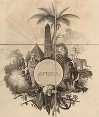
At the beginning of the 19th century, one of the finest map makers was Aaron Arrowsmith of London. His cartographic output numbered over 200 maps and several atlases. His individual maps were often made up of several large sheets, giving them a scale and scope not seen in the productions of his peers. We have collected his American large maps for years and recently added a group of European, African, and Asian maps to the collection. Arrowsmith mapped only what was known, rarely speculating or showing questionable information. His signature was large blank areas on his maps where there was no reliable information, as in his Map of Africa, 1802. He also relentlessly updated his maps as new discoveries were made. View Arrowsmith Large Maps of Europe, Africa and Asia. View All Arrowsmith Large Maps. View Arrowsmith Family Atlases.
|
 |
Star and Constellation Maps of the Heavens, 1693
Pardies, Ignace Gaston, Paris
Ignace Gaston Pardies created a series of six beautiful star and constellation maps in the late 17th century. All six map plates join together to make a unified view of the Heavens as seen from the Earth. Pardies drew the maps on the gnomonic projection which visualized the universe as a six-sided cube instead of a globe. This method allows for accurate measurement by straight lines between any point on the map. In order to assist users in visualizing various aspects of these star maps, we have georeferenced the maps in GIS and then joined them together, first as a cube, then as a globe, then in other projections, and in Google Earth - see our blog post on Pardies. View Star Maps
|
 |
Le Petit Atlas Maritime Recueil De Cartes et Plans Des Quatre Parties Du Monde, 1764
Bellin, Jacques Nicolas, Paris
The Petit Atlas Maritime is probably the best compilation of charts and plans of maritime towns and harbors in the mid 18th century, with coverage of North and South America, Europe, Africa, and Asia. Its 582 maps in five volumes give a rare and comprehensive view of the maritime world with its coasts, cities, ports, islands, and estuaries. The Petit Atlas Maritime was Bellin's largest and most comprehensive work. The quality of the engraving is superb, and the accuracy of the information shown is excellent, based on all the reports, charts, letters, maps and other narratives that Bellin had access to as the chief chart maker for the French Depot de la Marine in Paris. View Atlas
|
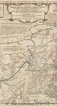 |
A Topographical Description of Such Parts of North America as are Contained in the (Annexed) Map of the Middle British Colonies, 1776
Pownall, Thomas; Evans, Lewis, London
This work contains an updated version of Lewis Evans' important 1755 "Map of the Middle British Colonies in North America," using the original plate engraved by James Turner with revisions and adding an eastern extension to cover New England; and Pownall's "Topographical Description" which describes the areas contained in the updated map; and six important appendices of writings by explorers in the region plus parts of Evans' original essay on his 1755 edition of the map. This copy of the Pownall belonged to Thomas Streeter (Streeter 826) and includes a rare 8 page prospectus for publishing the work that was printed in November, 1775. Henry Stevens ties Pownall's work directly to Evans, saying it "may be described as a new and much enlarged edition of both Evans' Map and his Analysis of 1755." Evans is considered "America's greatest eighteenth century cartographer" by Schwartz and Ehrenberg, and Pownall was hugely accomplished in pre-Revolutionary America, serving as Governor General of Massachusetts and traveling widely in the colonies in various roles in the British colonial administration. Pownall's map is considered the best updated edition of the Evans 1755 map, compared to the many later copies of Evans that were issued by Jefferys, Sayer, and others. In the prospectus, Pownall criticizes Jefferys' copy of Evans saying it "might as well be a map of the face of the moon." View Map and Text
|
|

|
Outlines Of The World. By A. Arrowsmith, Hydrographer to His Majesty. London; Published Jany 4th 1825, by A. & S. Arrowsmith, No. 10, Soho Square, 1825
Arrowsmith, Aaron Jr. , London
Arron Arrowsmith senior died in 1823. This atlas was published in 1825 and dedicated to him by his son, Aaron Arrowsmith, Jr. The title page includes the only know portrait of the elder Arrowsmith. The maps are excellent, and are probably the best atlas format maps issued by the Arrowsmith family until the London Atlas of 1838 and 1844 by John Arrowsmith, the nephew of Aaron senior. It is interesting to compare these maps to the large scale maps that Arrowsmith published as wall maps and in composite atlases - many of them appear to be derived from the larger versions. View Atlas
|
|
|
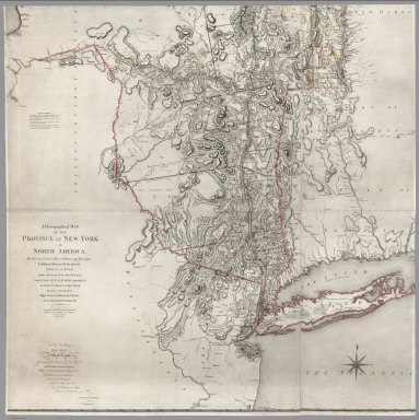
A Chorographical Map Of The Province Of New-York In North America, Divided into Counties, Manors, Patents and Townships, Exhibiting likewise all the private Grants of Land made and located in that Province; Compiled from Actual Surveys deposited in the Patent Office at New York, 1779
Sauthier, Claude Joseph; Faden, William, London
Four southern sheets of the six sheet map. Lacks the two northern sheets and the remaining four sheets are trimmed a few inches on the east and west sides - the owner was not interested in Vermont or Lake Erie! (see our reduced size issue of the complete map, also 1776). Otherwise, this is a superb copy of this extraordinary and rare map - the last and best of the large scale surveys of the American Colonies before the Revolution. Endless interesting detail. View Map
|
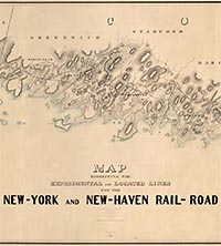 |
Map Exhibiting The Experimental and Located Lines for the New-York and New-Haven Rail-Road ... Projected and Drawn by P. Anderson Civil Engr., 1845
Anderson, P., Manuscript
This is probably the pre-publication manuscript drawing for the final printed version of this map that was issued in the same year - see our copy of the printed map. It is twice the size and scale of the final printed version, and is beautifully hand drawn and colored. It is amazing that a map this large has survived outside of an institutional library for so long. Apparently it was kept in a family for several generations. It shows the surveyed routes of the New York and New Haven Railroad from New Haven to New York City The line was opened in 1849. The map is unique for a railroad map in its huge size, large scale, elegance of drawing, and variety of information shown (houses, trails, rivers, turnpikes, lighthouses, harbors, hills, swamps, etc.). View Manuscript Map View Manuscript and Printed Map
|
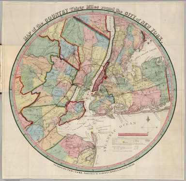 |
147 Maps and Images from Pocket Maps and Guides, 1822 - 1936
Various Authors, Various Places
Continuing our digitizing of Pocket Maps and Guides, this group of maps covers a wide range of places, time periods and styles. Included is Eddy's 1839 Map of the Country 30 Miles round the City of New York (pictured left), an early Railroad Map of the United States from 1860, a strip Map of the Hudson River, 1848, an early oil region map - Map of the Oil District of Pennsylvania, 1865, mineral deposits shown on Holt's California and Newvada Map 1873, a detailed map of Mount Desert Island and coastal Maine, 1890. a Radio Map of the United States 1925, and a stunning 20th century Bird's Eye View of California from 1936. View All Pocket Maps and Guides
|
|
|
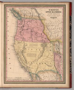
A New Universal Atlas Containing Maps of the various Empires, Kingdoms, States and Republics Of The World. With a special map of each of the United States, Plans of Cities &c. Comprehended in seventy sheets and forming a series of One Hundred And Seventeen Maps, Plans And Sections ..., 1849
Mitchell, Samuel Augustus, Philadelphia
Continuing our plan to have every issue of Mitchell's New Universal Atlas from 1846 to 1859 online, this copy is the 1849 issue. The Oregon and Upper California map is enlarged to include all of New Mexico and New Mexico is added to the title. This is the last edition published by Mitchell, all later editions published by Thomas, Cowperthwait and Co. and Charles Desilver. View Atlas
View All Online Mitchell Universal Atlases - 1846, 1848, 1849, 1853, 1855, 1859
|
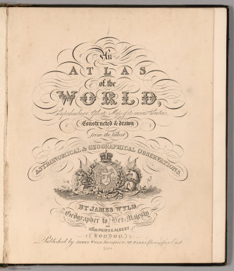 |
An Atlas of the World, Comprehending Separate Maps of its various Countries, Constructed & drawn from the latest Astronomical & Geographical Observations, 1864
Wyld, James, London.
A late edition of this atlas, published as early as 1836, and a successor to his father's (James Wyld, 1790-1836) 1824 General Atlas (see our copy). Several new maps of Australia and South Africa are added and the other maps have been updated to show railroad development. The American maps have been updated, but inadequately so in the West - the River Buenaventura is still flowing out of Salt Lake on the Mexico Map! View Atlas
|
|
|
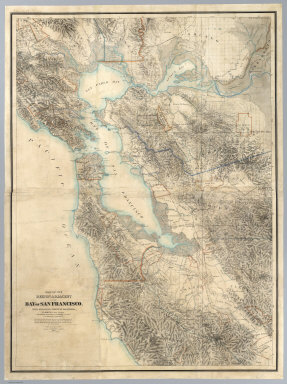
Map Of The Region Adjacent To The Bay Of San Francisco. State Geological Survey Of California, J.D. Whitney, State Geologist. The Coast, Rancho, Township and Section Lines from Materials furnished by the U.S. Coast Survey and the U.S. Surveyor General's Office, the Topography chiefly from Original Surveys by C.F. Hoffman, 1867
Hoffmann, Charles F.; Whitney, J.D.; Geological Survey of California, New York
This map is one of the earliest large scale maps of the entire San Francisco Bay area, made by the surveyors of the Geological Survey of California, under the direction of J.D. Whitney. It is the first edition of this map, and is interesting to compare to our second edition of 1873 to see changes in the rapidly growing settlements, roads, boundaries and newly documented features of the landscape. Both editions were printed in New York City by the expert lithographic printer Julius Bien. This first edition copy was mounted as a wall map. It was used in c. 1887 court case for which a "Lewis Survey" of part of Las Positas Rancho was outlined in red (this is present on the map but faint in lettering and outline). View Map
|
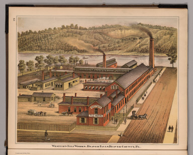 |
11 U.S. County Atlases, 1865 - 1908
Various Authors, Various Places
Continuing our scanning of representative U.S. County Atlases from the 19th century, this group of 11 includes St. Lawrence County-New York, Saratoga County-New York, Strafford County-New Hampshire, Ogle County-Illinois, Portage County-Ohio, Beaver County-Pennsylvania, Warren County-Pennsylvania, Winnebago and Boone Counties-Illinois, Marion and Monongalia Counties-West Virginia, Gibson County-Indiana, and Rush County-Indiana. These atlases have county and city maps, views of towns, farms, and industries, portraits and biographies of county leaders, and historical entries. View All County Atlases
|
 |
Centennial Map Of The United States and Territories Showing the Extent of Public Surveys, Indian and Military Reservations...& Other Details, 1878
U.S. General Land Office, Washington
16 sheets plus index sheet. 2nd ed.(1876 1st ed). At head of title: 1876. Not listed in Wheat or most other references. Related to the Centennial Atlas of the United States published in 1876, although those maps were on a somewhat larger scale (1"=12 to 20 miles, vs 1"=20 miles for this). When joined, these sheets would make a map 8 feet tall by 12 feet wide. View Map
|
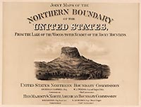 |
Joint Maps Of The Northern Boundary Of The United States, From The Lake Of The Woods To The Summit Of The Rocky Mountains, 1878
U.S. Northern Boundary Commission; Campbell, A., Washington
To accompany Campbell's Report on the Boundary. Originally issued in unbound folio. the boundary between the United States and Canada was set by the Oregon Treaty of 1846 but the surveying of the boundary was interrupted by the Civil War and not completed until 1875. These maps are highly detailed and show many cultural features along the boundary. The lithographic work is excellent. View Maps
|
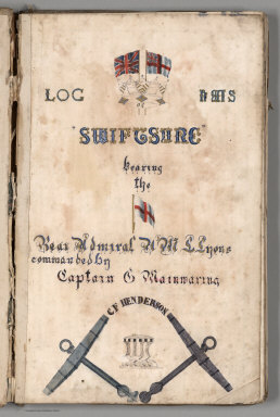 |
Log Of H.M.S. "Swiftsure" Bearing the (flag of) Rear Admiral H.M.L. Lyons commanded by Captain C. Mainwaring. C.F. Henderson, 1884
Mainwaring, C.; Henderson, C.F., Manuscript
This is a manuscript ship's log that begins to record a journey midway from Honolulu to Esquimalt in British Columbia, then down the west coast of the United States and the west coast of South America, around Cape Horn, and back to England. It begins in July, 1884 and ends in November, 1885. 16 beautifully drawn charts record the track of the steam and sail powered ship, showing stops in San Francisco, Mazatlan, San Blas, Valparaiso and Rio de Janeiro and other ports. Many drawings illustrate aspects of the ship and its equipment. The log itself records the weather and daily ship operations. An unusual highly illustrated document. Swiftsure is the name assigned to ten successive ships of the Royal (British) Navy, the first launched in 1573 and the most recent in 1971. This one was commissioned in 1871 and was the lead ship of the Swiftsure class battleships built in the late Victorian era. It operated under steam and sail and was ironclad. It was very fast for its time, 13.75 knots. It served as the Pacific Station flagship from 1882-1885 and 1888-1890. Renamed "Orontes" in 1901, she was scrapped in 1908. View Log Book
|
|
|
Pocket Mining Atlas. Compiled From The Latest Official Surveys, And The Most Authentic Sources. Engineering and Mining Journal, 1880
Bolitho, Edwin, New York.
Scarce. 24 of the 27 maps are western mining maps. A miniature mining atlas with many western maps. Not in any of the standard collections or references. There are maps of western states and detailed maps of mining areas showing claims. All of the detailed claim maps (except Dahlonega District in Georgia) appear on the verso of the state maps in Bradstreet's Pocket Atlas of 1882 (see our copy). At the end of the atlas there is a note by the publisher stating that any of the maps can be supplied for any use (We assume that Bradstreet made use of this offer) and that additional maps will be provided in "the forthcoming edition." Was there another, expanded edition? Atlas is bound into burgandy leather covers with "Pocket Mining Atlas." stamped in gilt. View Atlas
|
|
|
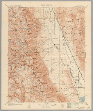
34 Historic Topographic Maps of the Sierra Nevada by the United States Geological Survey, 1891 - 1951
USGS (U.S. Geological Survey). Washington, D.C.
These 34 maps show changes in parts of the Sierra Nevada Mountains over a 60 year period. Included are maps of Yosemite, Big Trees, Dardanelles, Mt. Whitney, Bridgeport, Sonora, Mt. Lyell, Hawthorne, and Mariposa. All the maps are at a scale of 1:125,000 so the detail is excellent. View USGS Maps
|
|
|
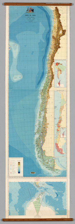
136 Wall Maps from the Collection of the University of California, Berkeley, Geography Department, 1900 - 2005
Various Publishers, Various Places
We recently entered into an agreement with the Geography Department at UC Berkeley to acquire over 600 of their 20th century wall maps of all parts of the world that are no longer used in teaching. In addition to digitizing those 600 maps, we agreed to digitize and put online a separate group of 156 wall maps retained by the Geography Departments that are still used in teaching - so that UC teachers and students could use the digitized maps in their presentations, lectures, and studies. And to be used and enjoyed by the general Internet public. The maps show the whole range of cartographic conventions used in the last 100 years. We have completed 136 of the 156 maps retained by UC and put them online now (we will complete the remaining 20 maps in that group plus the 600 we acquired in our next update). Highlights include the 1976 Floor of the Oceans by Tharp and Heezen, 1942 Rand McNally World Map for the Air Age, 1985 Bedrock Geology of the World by R.L. Larson, 1960 North and South Poles by Karl Wenschow, 1968 Mapa de Chile by the Institute Geografico Militar de Chile (pictured on left), 1979 Relief Map of California (a strange mash-up of a photograph of a plaster model of the state), 1966 Rio Grange Do Sul of Brazil by the Instituto Gaucho de Reforma Agraria, the stunning relief Map of Asia by Klett-Perthes, and the beautiful U.S. State Relief Maps by Allan Cartography. Because some of these maps are still being actively printed and sold by the publishers, we allow viewing only for those maps and give links to the websites where more recent versions of the maps are available. View All Wall Maps
|
nice to see a large collection of historical map. Thanks for giving common people to have a look at old maps. Keep the good work David. Good Luck. Aditya