- Featured Maps
- October 24, 2011
San Francisco Aerial Photographs 1938
We have put online a set of 164 large format, sharp, black and white vertical aerial photographs of San Francisco taken in 1938 from an airplane by Harrison Ryker, a pioneer in aerial photography. The photographs overlap each other and cover the entire city. The resolution is generally better than one foot or even higher with high contrast features allowing visibility of even the paint striping on a basketball court. Relative heights are frequently discernible based on the shadows cast of objects and structures. A handwritten date on the index map indicates the photographs were taken in August, 1938. The photographs are owned by the San Francisco Public Library and are a continuation of our collaboration with them on scanning and putting online important historical maps and views of San Francisco (including our prior collaboration on the 1905 San Francisco Sanborn Insurance Atlas).
Image number 18 of the set shows the active waterfront around the Ferry Building at the foot of Market Street:

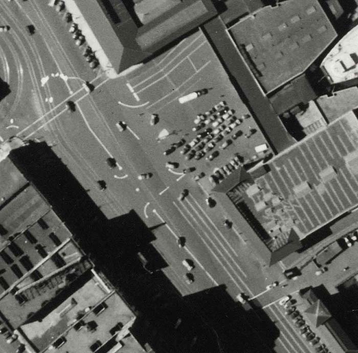
Enlarging the image to the area around the Ferry Building shows the high level of detail that can be seen:

Zooming to full resolution of the same scene shows cars and ships at the plaza next to the Ferry Building:
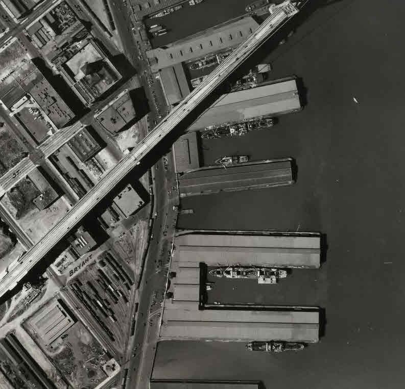
The adjoining image 17, to the south, shows activity of ships being unloaded to trains on the waterfront under the recently opened (November, 1936) San Francisco-Oakland Bay Bridge:
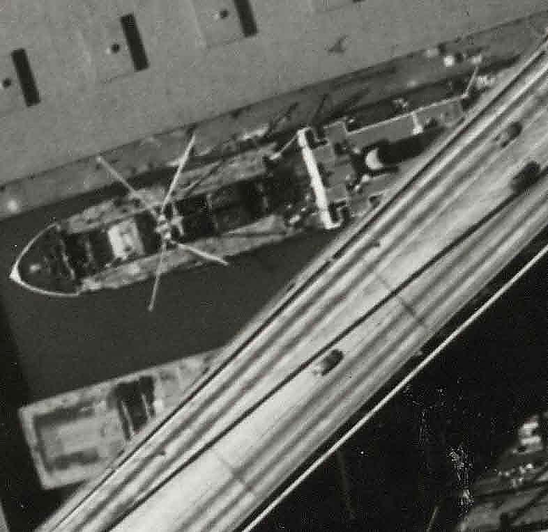
A closer in detail of the same image shows cars on the Bay Bridge above the ships at the docks:
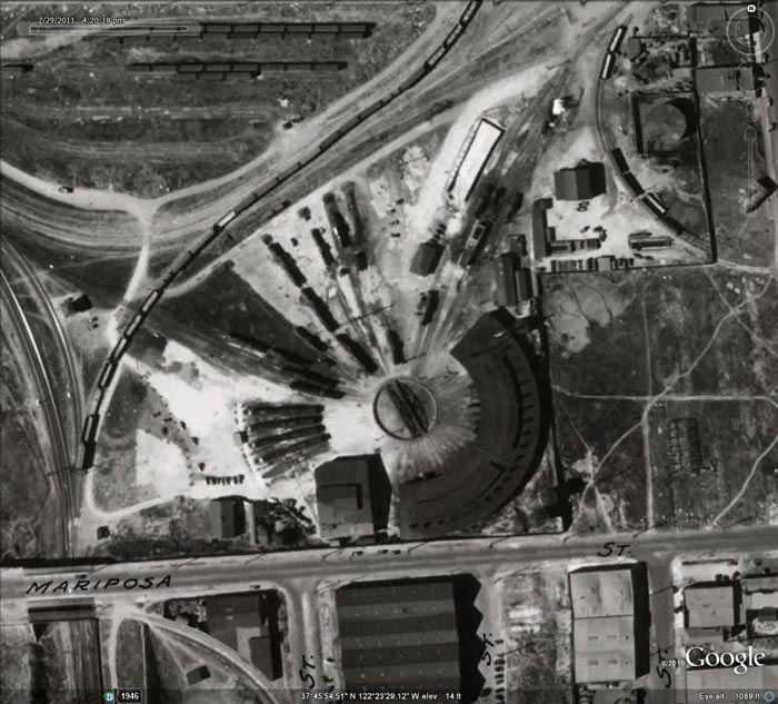
The Mission Bay Roundhouse (demolished early 1960's) of the Southern Pacific rail yards at Mariposa and 3rd streets is clearly visible on image 14:

In the San Francisco neighborhoods, all kinds of interesting details show up, like the vast outer Sunset sand dunes along Sunset Boulevard on image 148:

Image 85 shows the Calvary and Laurel Hill Cemeteries, later moved to Colma:

Crissy Army Airfield and the Presidio Main Post are seen in image 101:

Parts of the Presidio and other military sites in the city are whited out or blacked out, presumably because they show sensitive military installations, like this area of the Presidio near Baker Beach in image 129:

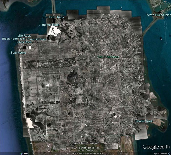
The index map shows how all the images overlap each other in covering the city, using hand drawn numbered rectangles on top of a 1937 map of San Francisco:

We have created a composite image of all 164 images joined together and georeferenced:

The georeferenced composite images are in Google Earth (requires app) below:
We also have an index layer in Google Earth for the same images that shows the overlap as well as identifying each image:

On mousing over any red image outline, the image number shows and reveals a pop up that allows downloading of the original image or the georeferenced image or the large composite image:

The georeferenced composite image and index can be viewed in the Google Earth desktop application (Composite, Index to Composite, opens in Places/Temporary Places). Or you can view them along with all the 300 plus Rumsey historical maps in Google Earth by downloading this link (opens in Places/Temporary Places, see the New Maps folder).
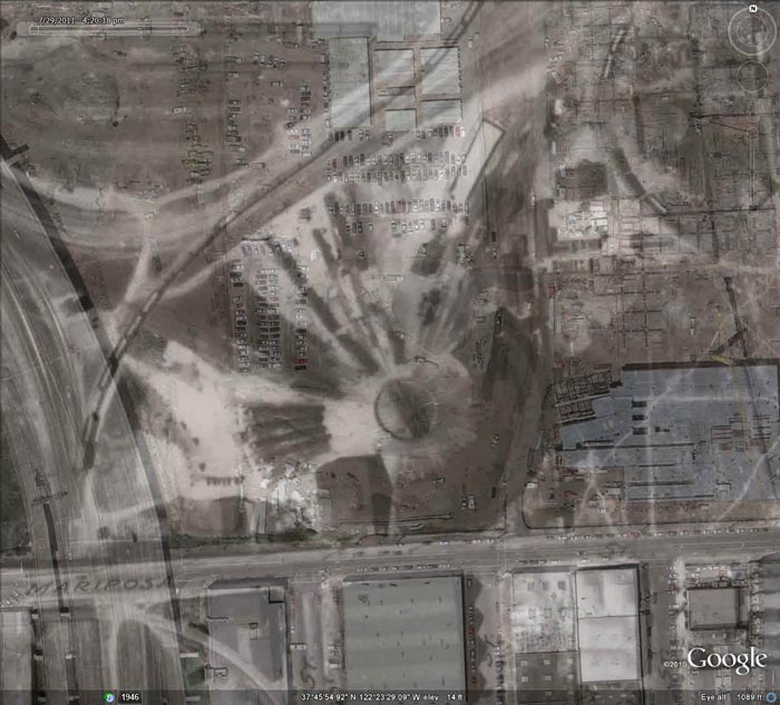
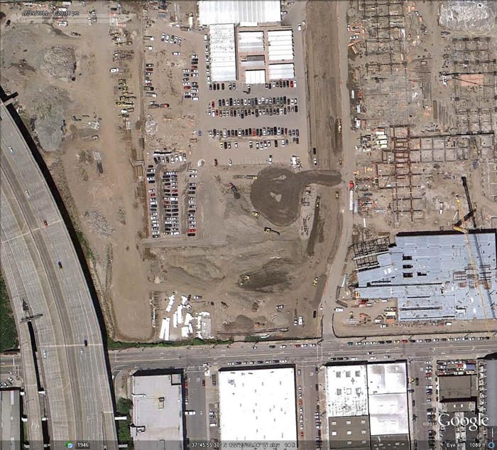
The overlay of the 1938 images on current satellite images in Google Earth allows for interesting time comparisons, as in this view of the Southern Pacific Mission Bay Roundhouse on image 14, seen blending into the current satellite image of the same area today showing construction of the Mission Bay campus of the University of California, San Francisco:
The person who created the 164 aerial views of San Francisco in 1938 was Harrison Ryker of Oakland, California:

Harrison C. Ryker (1898-1981)
Research by Dan Holmes, Librarian of the Rumsey Map Collection, uncovered the following information on Ryker. Harrison C. Ryker (1898-1981) was born in Oakdale, California. He married Charlotte Seward in the mid-1920s; after divorcing, he married Esther Miriam Munson in 1936. He served in the U.S. Army for several years in Germany with the post-World War I occupational forces, and partook of educational opportunities at the University of California, Berkeley. Expanding on his hobby in photography, Mr. Ryker teamed with various pilots beginning aerial photography services out of the Oakland Airport and throughout the West. Colleagues included Lage Wernstedt of the U.S. Forest Service. He also worked with the Fairchild Aerial Camera Company (including an aerial survey of Puerto Rico) and Clyde Sunderland of Pacific Aerial Surveys. As well, he took photographs of the devastating 1923 Berkeley Fire, archived in The Bancroft Library. By 1938 Mr. Ryker was listed in business as a map publisher (see Polk’s Oakland 1938 Street and Avenue Guide) based at 1924 Franklin St., Oakland. At that time, he had at least one patent pending for a stereoscope used for aerial photograph interpretation. Shortly after 1938 Ryker established his company address as Harrison C. Ryker, Inc., at 1000 Ashby Avenue, Berkeley, California (relocating to east Oakland in the 1950s). He subsequently manufactured pocket and desktop stereoscopes and a vertical Sketchmaster, instruments that were extensively used by educational institutions and the military, especially during World War II. An example of his stereoscope viewers was the M-11:

Advertisement for the Ryker Model M-11 Reflecting Stereoscope
Ryker's experience in aerial photography led to further involvement in photo interpretation and cartography. An article in the journal The Timberman (1933) describes means of distinguishing individual species of forest trees on aerial photos; later applications were terrain analysis for petroleum geology and unmasking of ground camouflage during wartime. His largest product was the Wernstedt Mahan map plotter, patented in 1954, which was a standard cartographic device for its time. His instruments are in use today in libraries, air photo collections, and earth sciences departments throughout America; they are in the instrument collections of the Archives of the History of American Psychology, and the Institute of Geographical Exploration at Harvard University has the Ryker M-11 Reflecting Stereoscope. Among his patents were (1) the adjustable pocket stereoscope filed with the United States Patent Office, patented December 1940, Patent No. 2,225,602; and (2) the stereoscope filed with the United States Patent Office, filed September 1, 1937, Serial No. 161,973, patented January 21, 1941, Patent No. 2,229,309. Harrison Ryker pioneered research in aerial photo interpretation. His work has been noted by A. Everett Wieslander, an early (1930s – 1950s) leader in the mapping of California vegetation and soils, in his Oral History produced by The Bancroft Library, and in a letter by Robert Colwell, Forestry Professor at the University of California, Berkeley. Some of our information regarding Harrison Ryker is from personal communications with Ryker's son, Harrison Clinton Ryker, a musicologist from Bellevue, Washington.
16 Comments on San Francisco Aerial Photographs 1938
Elizabeth F Thomas
on December 5, 2011 at 4:15PM wrote:
Image 85 must have been taken before 1932, as it depicts Laurel Hill before the buildings that comprised San Francisco College for Women were begun. How can this be verified?
David Rumsey
on December 7, 2011 at 11:33AM wrote:
Image 85 shows the main San Francisco College for Women building on the Lone Mountain site which is next to (just south of) the Laurel Hill cemetery. So I think our estimated date of 1938 is correct.
Dale Danley
on December 11, 2011 at 11:36AM wrote:
Wonderful maps. I just referenced an image to help put some of our Panhandle park work in historical context. Blog post is at http://panhandlepark.blogspot.com/2011/12/december-workday-wrap-up.html
Hal Goldberg
on January 27, 2012 at 4:04PM wrote:
Hi David, these aireal photos are incredible—especially liked the comments about Laurel Hill area.
Hal saeco aroma
Rebecca Bolger
on February 11, 2012 at 12:52AM wrote:
I’m an LIS student, and I’ve just got to say: This is the coolest website! Thanks so much for sharing this for free with your users.
Eric
on May 8, 2012 at 8:12AM wrote:
Rad!
Emelie Koshland
on May 30, 2012 at 6:22PM wrote:
Gosh i am so excited the quality and detailed quantity that can be found (but could not 10 years ago!) online. There is such amazing and quality and dedicated writing / archiving and publicizing on the internet. Thank you so much. Both you Mr. Ryker and even Google Maps for allowing me to see this amazing body of work you have lovingly preserved and presented. Bravo! You are the real thing that is so desperately sought in this commercial corporate piped in “information” fake fed world. It is in the blogs and the conservatory works like yours that is what is real and thankfully being shared and preserved. Thank you for this. It is a beautiful body of work and you should be very proud. It will take me some time, but i look forward at going over a lot more of this stuff!
Molly
on November 28, 2012 at 5:14PM wrote:
Stumbled across this web site and am so gratefully I did! I cannot wait to show this to others.
Craig
on March 23, 2013 at 9:13AM wrote:
Thanks for the info. Interesting to see our neighborhood before the houses were here.
Wayne
on March 26, 2013 at 9:46AM wrote:
My father served with Sunderland at the Naval Reserve Air Base at Oakland in the 1930's. I have a number of original in flight photos of unit aircraft marked with the Sunderland Studio stamp. Today I looked on Google Earth at the family home on 29th St and noticed a historical image dated 1938. Unbelievably clear images of the area that were taken by Clyde while my father was serving with him. The image answered many questions about a RR running thru the Mission and the exact route of a streetcar line running along 29th street.
George Harper
on June 20, 2013 at 11:44AM wrote:
I was searching for the Ocean Beach Riding Academy at 2200 48th ave SF, found this site, great. I lived by Sea Cliff and my Brother and other neighbor frinds used to camp in the dunes, play Beau Geste with the Foreign Legion. I was 13 in 1937. Swam at China Beach and Sutros, went on the rides at playland, swam at Fleishhacker Pool. Watched the two ships sink at Lands End. Real Busy!
Daniel
on September 4, 2014 at 8:07PM wrote:
This are the most incredible aerial photo collections ive seen so far! Aerial photos can always be converted into aerial mappings through gathering/collecting aerial photos and attached them piece by piece or using a software to make an improved quality of image. Thanks to this article David! Daniel-TerraServer
Jim
on December 2, 2015 at 9:13AM wrote:
Am writing a book on Clyde Sunderland, and would like to get in touch with Wayne, who wrote in on 3-26-13 regarding Sunderland and his [Wayne] father serving together.
Everett Erlandson
on January 10, 2019 at 6:59PM wrote:
Do you know why he took these photographs? Was he commissioned by the San Francisco city government or by the Federal government? Seems like a lot of work for a hobby. But beautiful, just the same.
Jeremy Lay
on February 9, 2019 at 1:03AM wrote:
I enjoyed viewing the maps immensely, thank you. I was equally fascinated to learn about Harrison Ryker and his amazing life, hobby/business and innovations. What a great man! Regards, Jeremy (Scotland)
very useful and informative blog
laws