Who What Where WhenWHATShow MoreWHO
WHEN
|
Author
Andriveau-Goujon, E. (Eugène), 1832-1897
Full Title
(25) Amérique du Sud. E. Andriveau-Goujon, éditeur, 4, Rue du Bac, Paris, 1878. Gravé chez L. Wuhrer, Rue de l'Abbé de l'Epée 4; Paris, Imp. F. Dufrenoy.
List No
14008.029
Note
Hand-colored, engraved map of South America, showing railroads, water routes with distances, ocean currents and glaciers (on double plate with decorative border). Includes legend indicating European colonies (French, English and Dutch), as well as 5 bar scales and a scale statement. "Longitude ouest du Méridien de Paris". With inset: Iles Galapagos (Dépendance de la République de l'Équateur).
Author
[Brault, Louis-Deìsireì-Leìon (1839 - 1885), DÉPÔT DES CARTES ET PLANS DE LA MARINE (FRENCH NAVY)]
Full Title
(Covers to) Océan Atlantique Nord / Cartes Mensuelles de la Direction des Vents
List No
15646.001
Note
Date estimated.
Author
[Brault, Louis-Deìsireì-Leìon (1839 - 1885), DÉPÔT DES CARTES ET PLANS DE LA MARINE (FRENCH NAVY)]
Full Title
Type No. 1.; Type No.2. Atlantique Nord. Cartes Types Des Movements Plus Generaux De L'Atmosphere Inferieeure...
List No
15646.002
Note
Date estimated.
Author
[Brault, Louis-Deìsireì-Leìon (1839 - 1885), DÉPÔT DES CARTES ET PLANS DE LA MARINE (FRENCH NAVY)]
Full Title
Type No. 3.; Type No.4. Atlantique Nord. Cartes Types Des Movements Plus Generaux De L'Atmosphere Inferieeure...
List No
15646.003
Note
Date estimated.
Author
[Brault, Louis-Deìsireì-Leìon (1839 - 1885), DÉPÔT DES CARTES ET PLANS DE LA MARINE (FRENCH NAVY)]
Full Title
Janvier. Océan Atlantique Nord / Cartes Mensuelles de la Direction des Vents
List No
15646.004
Note
Date estimated.
Author
[Brault, Louis-Deìsireì-Leìon (1839 - 1885), DÉPÔT DES CARTES ET PLANS DE LA MARINE (FRENCH NAVY)]
Full Title
Fevrier> Océan Atlantique Nord / Cartes Mensuelles de la Direction des Vents
List No
15646.005
Note
Date estimated.
Author
[Brault, Louis-Deìsireì-Leìon (1839 - 1885), DÉPÔT DES CARTES ET PLANS DE LA MARINE (FRENCH NAVY)]
Full Title
Mars. Océan Atlantique Nord / Cartes Mensuelles de la Direction des Vents
List No
15646.006
Note
Date estimated.
Author
[Brault, Louis-Deìsireì-Leìon (1839 - 1885), DÉPÔT DES CARTES ET PLANS DE LA MARINE (FRENCH NAVY)]
Full Title
Avril. Océan Atlantique Nord / Cartes Mensuelles de la Direction des Vents
List No
15646.007
Note
Date estimated.
Author
[Brault, Louis-Deìsireì-Leìon (1839 - 1885), DÉPÔT DES CARTES ET PLANS DE LA MARINE (FRENCH NAVY)]
Full Title
Mai. Océan Atlantique Nord / Cartes Mensuelles de la Direction des Vents
List No
15646.008
Note
Date estimated.
Author
[Brault, Louis-Deìsireì-Leìon (1839 - 1885), DÉPÔT DES CARTES ET PLANS DE LA MARINE (FRENCH NAVY)]
Full Title
Juin. Océan Atlantique Nord / Cartes Mensuelles de la Direction des Vents
List No
15646.009
Note
Date estimated.
Author
[Brault, Louis-Deìsireì-Leìon (1839 - 1885), DÉPÔT DES CARTES ET PLANS DE LA MARINE (FRENCH NAVY)]
Full Title
Juillet. Océan Atlantique Nord / Cartes Mensuelles de la Direction des Vents
List No
15646.010
Note
Date estimated.
Author
[Brault, Louis-Deìsireì-Leìon (1839 - 1885), DÉPÔT DES CARTES ET PLANS DE LA MARINE (FRENCH NAVY)]
Full Title
Aout. Océan Atlantique Nord / Cartes Mensuelles de la Direction des Vents
List No
15646.011
Note
Date estimated.
Author
[Brault, Louis-Deìsireì-Leìon (1839 - 1885), DÉPÔT DES CARTES ET PLANS DE LA MARINE (FRENCH NAVY)]
Full Title
Septembre. Océan Atlantique Nord / Cartes Mensuelles de la Direction des Vents
List No
15646.012
Note
Date estimated.
Author
[Brault, Louis-Deìsireì-Leìon (1839 - 1885), DÉPÔT DES CARTES ET PLANS DE LA MARINE (FRENCH NAVY)]
Full Title
Octobre. Océan Atlantique Nord / Cartes Mensuelles de la Direction des Vents
List No
15646.013
Note
Date estimated.
Author
[Brault, Louis-Deìsireì-Leìon (1839 - 1885), DÉPÔT DES CARTES ET PLANS DE LA MARINE (FRENCH NAVY)]
Full Title
Novembre. Océan Atlantique Nord / Cartes Mensuelles de la Direction des Vents
List No
15646.014
Note
Date estimated.
Author
[Brault, Louis-Deìsireì-Leìon (1839 - 1885), DÉPÔT DES CARTES ET PLANS DE LA MARINE (FRENCH NAVY)]
Full Title
Decmbre. Océan Atlantique Nord / Cartes Mensuelles de la Direction des Vents
List No
15646.015
Note
Date estimated.
Author
Truskot, Ivan (1721-1786)
Full Title
Karta, predstavliaiushchaia Pol’shu i Moldaviiu s okolo lezhashchimi zemliami, sochinennaia pri Imper.[atorskoi] Akademii Nauk po noveishim izvestiiam Tituliarnym sovetnikom i Ad’iutantom Ivanom Truskotom [i.e. Map Displaying Poland and Moldavia with Surrounding Lands, Compiled Basing on the Latest Data by Titular Councilor, Adjunct Professor Ivan Truskot in the Imperial Academy of Sciences]
List No
15642.000
Author
SCHWEIZERISCHEN OBERPOSTDIREKTION
Full Title
Schweizerische Postverwaltung. Übersicht der internen Postverbindungen (mit den ausländischen Anschlüssen). Winterdienst 1902/03. / Administration des Postes suisses. Tableau des Communicators postales internes et des routes étragers correspondants. Service d’hiver 1902/03.
List No
15643.000
Author
K.K. ÖSTERREICHISCHE STAATSBAHNEN [IMPERIAL & ROYAL AUSTRIAN RAILWAYS]
Full Title
K.k. Österreichische Staatsbahnen. K.k. Nordwestbahndirektion. / Linien: Nordwestbahnhof – Tetschen Nordwestbahnhof - (Mittelgrund), Iglau Nordwestbahnhof – Iglau Stadtbahnhof, Schreckenstein – Aussig Templitzerbahnhof.
List No
15644.000
Author
鈴木茂行 [SUZUKI Shigeyuki] (fl. 1895 - 1903)
Full Title
新撰臺灣明細全圖 [New, Complete and Detailed Map of Taiwan].
List No
15645.001
Author
Anonymous
Full Title
Manuscript Map
List No
15645.002
Note
"On the verso is an unfinished manuscript map that depicts a locality, with all details unlabelled, with sub-jurisdictions outlined in the own bright hues, and a river running through it, while a legend, upper-right, defines unused symbols. We have not been able to identify the subject of the map, and even whether it pertains in any way to Taiwan. However, the note in the lower right, seems to refer to “Nagai Village”, which if true might refer to a town in the Yamagata Prefecture of north-central Japan. This is perhaps a matter for further research." (See Pub note)
Author
Dallas, George M.
Full Title
[Discussing The Recovery of John Melish's Map of Pennsylvania] Autograph Letter Signed, "George M. Dallas," to Auditor General David Mann
List No
15637.000
Author
Kiepert, Heinrich, 1818-1899
Full Title
(Heinrich Kiepert original manuscripts). 1885.
List No
13116.001
Note
Handwritten letters by German geographer and cartographer Heinrich Kiepert, foremost authority on the geography of Ottoman Empire. The letter dated November 18, 1885 on blue sheets 22x14 or smaller, text addressed to the map published and his personal friend Dietrich Reimer, discussed and untitled map Kiepert was working on in November, 1885, probably one of the maps Kiepert and Reimer published together. The letter dated February 2, 1885 addressed to unknown scientist in Vienna, includes his annotations and remarks to the map of Lycia, a geopolitical region in the southwest part of Anatolia, in Anatalya in Turkey, which was a result of the Austrian archaeological expedition to the region. In the letter Kiepert mentions an archeologist Alexander Christian Leopold Conze, 1931-1914 sent him a map of Lycia. According to the note the expedition brought with them three Kiepert's maps, which were by coincidence tossed overboard off coast of the Island of Kekova.
Author
Kiepert, Heinrich, 1818-1899
Full Title
(Heinrich Kiepert original manuscripts). 1885.
List No
13116.002
Note
Handwritten letters by German geographer and cartographer Heinrich Kiepert, foremost authority on the geography of Ottoman Empire. The letter dated November 18, 1885 on blue sheets 22x14 or smaller, text addressed to the map published and his personal friend Dietrich Reimer, discussed and untitled map Kiepert was working on in November, 1885, probably one of the maps Kiepert and Reimer published together. The letter dated February 2, 1885 addressed to unknown scientist in Vienna, includes his annotations and remarks to the map of Lycia, a geopolitical region in the southwest part of Anatolia, in Anatalya in Turkey, which was a result of the Austrian archaeological expedition to the region. In the letter Kiepert mentions an archeologist Alexander Christian Leopold Conze, 1931-1914 sent him a map of Lycia. According to the note the expedition brought with them three Kiepert's maps, which were by coincidence tossed overboard off coast of the Island of Kekova.
Author
Kiepert, Heinrich, 1818-1899
Full Title
(Heinrich Kiepert original manuscripts). 1885.
List No
13116.003
Note
Handwritten letters by German geographer and cartographer Heinrich Kiepert, foremost authority on the geography of Ottoman Empire. The letter dated November 18, 1885 on blue sheets 22x14 or smaller, text addressed to the map published and his personal friend Dietrich Reimer, discussed and untitled map Kiepert was working on in November, 1885, probably one of the maps Kiepert and Reimer published together. The letter dated February 2, 1885 addressed to unknown scientist in Vienna, includes his annotations and remarks to the map of Lycia, a geopolitical region in the southwest part of Anatolia, in Anatalya in Turkey, which was a result of the Austrian archaeological expedition to the region. In the letter Kiepert mentions an archeologist Alexander Christian Leopold Conze, 1931-1914 sent him a map of Lycia. According to the note the expedition brought with them three Kiepert's maps, which were by coincidence tossed overboard off coast of the Island of Kekova.
Author
Berghaus, Heinrich, 1797-1884
Full Title
Autograph Book Order by Heinrich Berghaus signed Munich, 16 Jan. 1828.
List No
15635.000
Note
Folio. 1 p. (watermark: shell). In German.
Author
American Airlines Inc.
Full Title
(Covers to) American Airlines system map. Route of the flagships ... in relation to the air transport system of the United States ... Prepared for American Airlines, Inc. Copyright, General Drafting Co., Inc., 21 West Street, New York, N.Y. ... (with 12 strip maps on verso.) (cover title) Flagship information : American Airlines System. Form no. T-106B- Printed in U.S.A.
List No
11673.001
Note
Folded advertisement for American Airline Systems with pockets holding informational items, air shipping pamphlet with map showing certified routes on verso, also includes note pads. In the center: holding post cards and envelope. Includes a folded map in the right pocket. A pictorial map, showing routes of American and other, connecting airlines, points of interest, etc. 59x79. Includes connections to Mexico, Cuba, the Bahamas and southern Canada. Folded into self covers 21 x 10 titled "American Airlines system map. Route of the flagships." On verso: 12 strip maps of the routes in greater detail, "Cloud atlas," and a text section with illus. called "The Radio beam is the highway of the air. "Relief shown by hachures and spot heights.
Author
American Airlines Inc.
Full Title
American Airline System : Route of the flagships - in relation to the air transport system of the United States ... Prepared for American Airlines, Inc. Copyright, General Drafting Co., Inc., 21 West Street, New York, N.Y. ... (Cover title) American Airline System. (with 12 strip maps on verso.) (cover title) Flagship information : American Airlines System. Form no. T-106B- Printed in U.S.A.
List No
11673.011
Note
A pictorial map of the United States. Showing routes of American and other, connecting airlines, points of interest, etc. 59x79. Includes connections to Mexico, Cuba, the Bahamas and southern Canada. Folded into self covers 21 x 10 titled "American Airlines system map. Route of the flagships." Includes map explanation. On verso: 12 strip maps of the routes in greater detail, "Cloud atlas," and a text section with illus. called "The Radio beam is the highway of the air. "Relief shown by hachures and spot heights.
Author
American Airlines Inc.
Full Title
American Airline System : Route of the flagships - in relation to the air transport system of the United States ... Prepared for American Airlines, Inc. Copyright, General Drafting Co., Inc., 21 West Street, New York, N.Y. ... (Cover title) American Airline System. (with 12 strip maps on verso.) (cover title) Flagship information : American Airlines System. Form no. T-106B- Printed in U.S.A.
List No
11673.012
Note
A pictorial map of the United States. Showing routes of American and other, connecting airlines, points of interest, etc. 59x79. Includes connections to Mexico, Cuba, the Bahamas and southern Canada. Folded into self covers 21 x 10 titled "American Airlines system map. Route of the flagships." Includes map explanation. On verso: 12 strip maps of the routes in greater detail, "Cloud atlas," and a text section with illus. called "The Radio beam is the highway of the air. "Relief shown by hachures and spot heights.
Author
[Union Pacific Railway Company. Passenger Department, Rand McNally & Co.]
Full Title
(Covers to) Sights and Scenes in California for the Tourists. Complement of the Passenger Department, Union Pacific Ry. Omaha, Neb. Rand McNally & co., Printers, Chicago. Copyright, 1888, by J. S. Tebbets, General Passenger Agent, Union Pacific Ry, Omaha, Neb. (with) Tourist Map of Union Pacific and Connecting Lines. (cover title) California. Sights and Scenes for the Tourist.
List No
11904.001
Note
Pictorial folded map inserted loose in the accompanying guide book. 33 pages with information on places of interest in the state for the tourists, including 2 pages of advertisements and black and white photos. Map shows Union Pacific and connecting routes from Omaha and Kansas City to the west coast Los Angeles in the south and Seattle in the north. Includes profile of the comparative heights of the mountains from San Francisco to Omaha and inset "Map of the loop". The route shown in red. Includes vignettes showing places of interest, mining, agricultural products and livestock. Relief shown pictorially and by hachures.
Author
[Union Pacific Railway Company. Passenger Department, Rand McNally & Co.]
Full Title
(Title Page to) Sights and Scenes in California for the Tourists. Complement of the Passenger Department, Union Pacific Ry. Omaha, Neb. Rand McNally & co., Printers, Chicago. Copyright, 1888, by J. S. Tebbets, General Passenger Agent, Union Pacific Ry, Omaha, Neb. (with) Tourist Map of Union Pacific and Connecting Lines. (cover title) California. Sights and Scenes for the Tourist.
List No
11904.002
Note
Pictorial folded map inserted loose in the accompanying guide book. 33 pages with information on places of interest in the state for the tourists, including 2 pages of advertisements and black and white photos. Map shows Union Pacific and connecting routes from Omaha and Kansas City to the west coast Los Angeles in the south and Seattle in the north. Includes profile of the comparative heights of the mountains from San Francisco to Omaha and inset "Map of the loop". The route shown in red. Includes vignettes showing places of interest, mining, agricultural products and livestock. Relief shown pictorially and by hachures.
Author
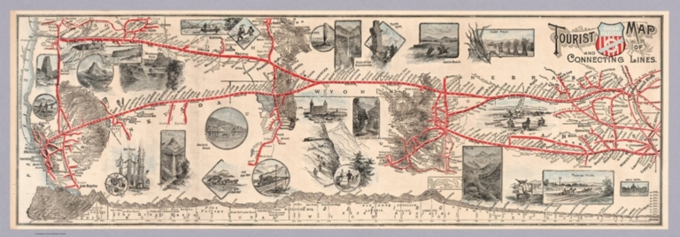
[Union Pacific Railway Company. Passenger Department, Rand McNally & Co.]
Full Title
Tourist Map of Union Pacific and Connecting Lines. (to accompany) Sights and Scenes in California for the Tourists. Complement of the Passenger Department, Union Pacific Ry. Omaha, Neb. Rand McNally & co., Printers, Chicago. Copyright, 1888, by J. S. Tebbets, General Passenger Agent, Union Pacific Ry, Omaha, Neb. (cover title) California. Sights and Scenes for the Tourist.
List No
11904.020
Note
Pictorial folded map inserted loose in the accompanying guide book. 33 pages with information on places of interest in the state for the tourists, including 2 pages of advertisements and black and white photos. Map shows Union Pacific and connecting routes from Omaha and Kansas City to the west coast Los Angeles in the south and Seattle in the north. Includes profile of the comparative heights of the mountains from San Francisco to Omaha and inset "Map of the loop". The route shown in red. Includes vignettes showing places of interest, mining, agricultural products and livestock. Relief shown pictorially and by hachures.
Author
Metropolitan Water District of Southern California (Calif.)
Full Title
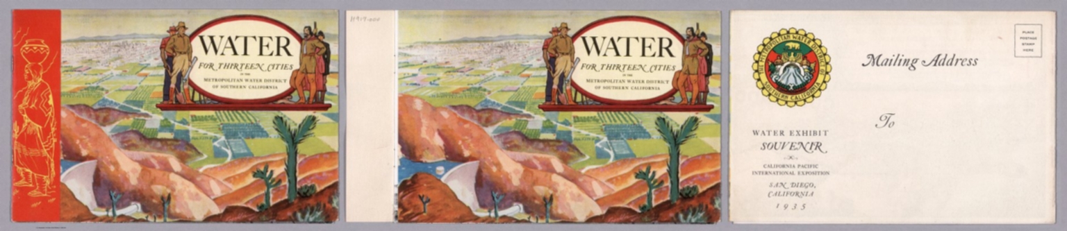
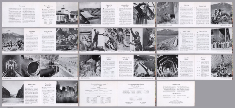
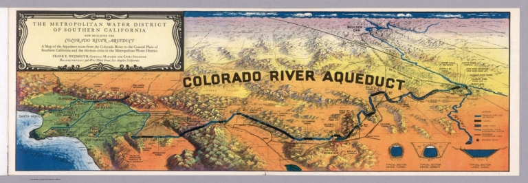
(Covers to) Water for thirteen cities in the Metropolitan Water District of Southern California : a brief description of the Colorado River Aqueduct, America's largest construction job in progress today. Issued by the Metropolitan Water District of Southern California. Second printing - August, 1935. Booklet prepared by Don J. Kinsey, Assistant to the General Manager, The Metropolitan Water District of Southern California. (with map) Metropolitan Water District of Southern California : Now building the Colorado River aqueduct. A Map of the Aqueduct Route ... Frank E. Weymouth.
List No
11917.001
Note
Informational brochure promoting the Colorado River aqueduct, extending across the entire state of California. with title page, 23 pages of text, black and white photos and a color pictorial fold out map of Colorado River aqueduct. Bound in pictorial mailing wrappers, illustrated with a photograph of Parker Dam, where aqueduct begins with mailing address on verso, with label "Water exhibit souvenir : California Pacific Exhibition, San Diego, California 1935. Bird's eye view map which folds out from the back cover shows how the Aqueduct will deliver water across mountain and desert country to each city in the Metropolitan Water District., pressure pipe line, tunnels, lined canals, member cities, etc. Includes 3 profiles showing Typical section grade tunnel; typical section grade conduit; Typical section lined canal. Relief shown pictorially. Includes legend.
Author
Metropolitan Water District of Southern California (Calif.)
Full Title
(Title Page to) Water for thirteen cities in the Metropolitan Water District of Southern California : a brief description of the Colorado River Aqueduct, America's largest construction job in progress today. Issued by the Metropolitan Water District of Southern California. Second printing - August, 1935. Booklet prepared by Don J. Kinsey, Assistant to the General Manager, The Metropolitan Water District of Southern California. (with map) Metropolitan Water District of Southern California : Now building the Colorado River aqueduct. A Map of the Aqueduct Route ... Frank E. Weymouth.
List No
11917.002
Note
Informational brochure promoting the Colorado River aqueduct, extending across the entire state of California. with title page, 23 pages of text, black and white photos and a color pictorial fold out map of Colorado River aqueduct. Bound in pictorial mailing wrappers, illustrated with a photograph of Parker Dam, where aqueduct begins with mailing address on verso, with label "Water exhibit souvenir : California Pacific Exhibition, San Diego, California 1935. Bird's eye view map which folds out from the back cover shows how the Aqueduct will deliver water across mountain and desert country to each city in the Metropolitan Water District., pressure pipe line, tunnels, lined canals, member cities, etc. Includes 3 profiles showing Typical section grade tunnel; typical section grade conduit; Typical section lined canal. Relief shown pictorially. Includes legend.
Author
Metropolitan Water District of Southern California (Calif.)
Full Title
(Composite Text) Water for thirteen cities in the Metropolitan Water District of Southern California : a brief description of the Colorado River Aqueduct, America's largest construction job in progress today. Issued by the Metropolitan Water District of Southern California. Second printing - August, 1935. Booklet prepared by Don J. Kinsey, Assistant to the General Manager, The Metropolitan Water District of Southern California. (with map) Metropolitan Water District of Southern California : Now building the Colorado River aqueduct. A Map of the Aqueduct Route ... Frank E. Weymouth.
List No
11917.003
Note
Informational brochure promoting the Colorado River aqueduct, extending across the entire state of California. with title page, 23 pages of text, black and white photos and a color pictorial fold out map of Colorado River aqueduct. Bound in pictorial mailing wrappers, illustrated with a photograph of Parker Dam, where aqueduct begins with mailing address on verso, with label "Water exhibit souvenir : California Pacific Exhibition, San Diego, California 1935. Bird's eye view map which folds out from the back cover shows how the Aqueduct will deliver water across mountain and desert country to each city in the Metropolitan Water District., pressure pipe line, tunnels, lined canals, member cities, etc. Includes 3 profiles showing Typical section grade tunnel; typical section grade conduit; Typical section lined canal. Relief shown pictorially. Includes legend.
Author
Metropolitan Water District of Southern California (Calif.)
Full Title
(Composite text) Water for thirteen cities in the Metropolitan Water District of Southern California : a brief description of the Colorado River Aqueduct, America's largest construction job in progress today. Issued by the Metropolitan Water District of Southern California. Second printing - August, 1935. Booklet prepared by Don J. Kinsey, Assistant to the General Manager, The Metropolitan Water District of Southern California. (with map) Metropolitan Water District of Southern California : Now building the Colorado River aqueduct. A Map of the Aqueduct Route ... Frank E. Weymouth.
List No
11917.004
Note
Informational brochure promoting the Colorado River aqueduct, extending across the entire state of California. with title page, 23 pages of text, black and white photos and a color pictorial fold out map of Colorado River aqueduct. Bound in pictorial mailing wrappers, illustrated with a photograph of Parker Dam, where aqueduct begins with mailing address on verso, with label "Water exhibit souvenir : California Pacific Exhibition, San Diego, California 1935. Bird's eye view map which folds out from the back cover shows how the Aqueduct will deliver water across mountain and desert country to each city in the Metropolitan Water District., pressure pipe line, tunnels, lined canals, member cities, etc. Includes 3 profiles showing Typical section grade tunnel; typical section grade conduit; Typical section lined canal. Relief shown pictorially. Includes legend.
Author
Pan American World Airways.
Full Title
(Covers to) Flying Clipper-wise. Pan American World Airways.
List No
12222.001
Note
Front and back covers.
Author
Pan American World Airways.
Full Title
(Composite Text) Flying Clipper-wise. Pan American World Airways.
List No
12222.002
Author
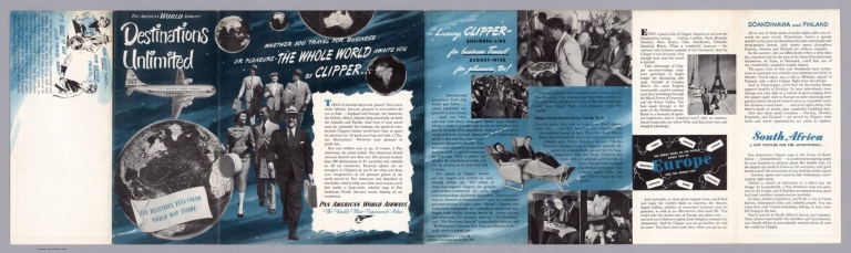
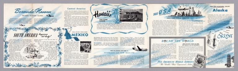
[Pan American World Airways., Jeppesen and Company]
Full Title
(Text and Views) Pan American World Airways Destinations Unlimited.
List No
12222.003
Author
[Pan American World Airways., Jeppesen and Company]
Full Title
(Text and Views) Pan American World Airways Destinations Unlimited.
List No
12222.004
Author
[Pan American World Airways., Jeppesen and Company]
Full Title
(World Route Map, Pan Am Clippers, Pan American World Airways.)
List No
12222.005
Note
Full color with shaded relief.
Author
Finney, Ethel
Full Title
(Covers to) [Egyptian/German manuscript schoolgirl atlas].
List No
14317.001
Note
Covers to school atlas, drawn by Ethel Finney at the Deutsche Schule zu Alexandrien (German School in Alexandria) in 1900. Blue paper covers; bound with thread. Bookplate on cover with Finney's signature, date and class (II).
Author
Finney, Ethel
Full Title
Alexandrien.
List No
14317.002
Note
Manuscript map of Alexandria, Egypt. Shows streets and drainage. Drawn in graphite and colored blue pencil, with a penciled grid beneath drawing. Lettering in cursive. Map is 17 x 21 cm, on sheet 20 x 25 cm.
Author
Finney, Ethel
Full Title
Nil - Delta.
List No
14317.003
Note
Two manuscript maps of the Nile River Delta, Egypt. Maps show cities, railways, topography, lakes, drainage and coastline. Relief shown in hachures. Drawn in graphite, with a penciled grid beneath drawing. Descriptive text in lower margin. Lettering in cursive. Together, maps are 36 x 21 cm, on facing sheets, together 40 x 25 cm.
Author
Finney, Ethel
Full Title
Kairo.
List No
14317.004
Note
Two manuscript maps of Cairo, Egypt (top), and Haizer, Algeria (bottom). Maps show railways, streets, topography, lakes and drainage. Relief shown in hachures. Drawn in graphite, ink and watercolor. Descriptive text in lower margin of top map. Lettering in cursive. Together, maps are 39 x 25 cm, on facing sheets, together 40 x 25 cm.
Author
Finney, Ethel
Full Title
[Nile River Delta].
List No
14317.005
Note
Two manuscript maps of the Nile River Delta, Egypt. Maps show cities, railways, lakes, drainage and coastline. Drawn in ink and watercolor. Lettering in cursive. Together, maps are 37 x 24 cm, on facing sheets, together 40 x 25 cm.
Author
Finney, Ethel
Full Title
[Nile River, to Lake Victoria]. Alexandrien, den 22/3/1900. E. F.
List No
14317.006
Note
Manuscript map of the Nile River to Lake Victoria, Egypt. Shows cities, topography, lakes, drainage and coastlines. Relief shown in hachures. Drawn in ink and watercolor. Lettering in cursive. Map is 30 x 18 cm, on facing sheets, together 40 x 25 cm.
Author
Finney, Ethel
Full Title
Nil (bis Assouan).
List No
14317.007
Note
Manuscript map of the Nile River to Aswan, Egypt. Shows cities, seas, lakes, drainage and coastlines. Drawn in ink and watercolor. Lettering in cursive. Map is 16 x 21 cm, on sheet 20 x 25 cm.
Author
Finney, Ethel
Full Title
[Watercolor palette].
List No
14317.008
Note
Watercolor palette tested through a series of whimsical brushstrokes. On final page of atlas.
Author
Wyld, James, 1812-1887
Full Title
(Covers to) Wyld's new map of gold fields of Transvaal. James Wyld, Geographer to the Queen, 11 & 12, Charing Cross, S.W. and 2, Royal Exchange, E.C.
List No
14268.001
Note
Covers to Wyld's new map of gold fields of Transvaal, published in London, circa 1890. Brown board covers. With title and imprint printed on paper pasted to front cover, as well as a pasted spine title: Goldfields of Transvaal. Unfolded to 18 x 26 cm. Verso of front cover has advertisement for various map series by Wyld. Front cover torn apart from item on this copy. (Date taken from map.)
|


![Karta, predstavliaiushchaia Pol’shu i Moldaviiu s okolo lezhashchimi zemliami, sochinennaia pri Imper.[atorskoi] Akademii Nauk po noveishim izvestiiam Tituliarnym sovetnikom i Ad’iutantom Ivanom Truskotom [i.e. Map Displaying Poland and Moldavia with Surrounding Lands, Compiled Basing on the Latest Data by Titular Councilor, Adjunct Professor Ivan Truskot in the Imperial Academy of Sciences]](https://www.davidrumsey.com/rumsey/Size2/RUMSEY~8~1/205/15642000.jpg)


![新撰臺灣明細全圖 [New, Complete and Detailed Map of Taiwan].](https://www.davidrumsey.com/rumsey/Size2/RUMSEY~8~1/205/15645001.jpg)

![[Discussing The Recovery of John Melish's Map of Pennsylvania] Autograph Letter Signed, "George M. Dallas," to Auditor General David Mann](https://media.davidrumsey.com/MediaManager/srvr?mediafile=/Size3/RUMSEY~8~1/205/15637000.jpg)


![Covers: [Egyptian/German manuscript schoolgirl atlas].](https://www.davidrumsey.com/rumsey/Size2/RUMSEY~8~1/205/14317001.jpg)


![[Nile River Delta].](https://www.davidrumsey.com/rumsey/Size2/RUMSEY~8~1/205/14317005.jpg)
![[Nile River, to Lake Victoria].](https://www.davidrumsey.com/rumsey/Size2/RUMSEY~8~1/205/14317006.jpg)

![[Watercolor palette].](https://www.davidrumsey.com/rumsey/Size1/RUMSEY~8~1/205/14317008.jpg)
