COLLECTION NAME:
David Rumsey Historical Map Collection
Record
Author:
Anonymous
Date:
1895
Short Title:
Manuscript Map
Type:
Manuscript Map
Obj Height cm:
78
Obj Width cm:
52
Note:
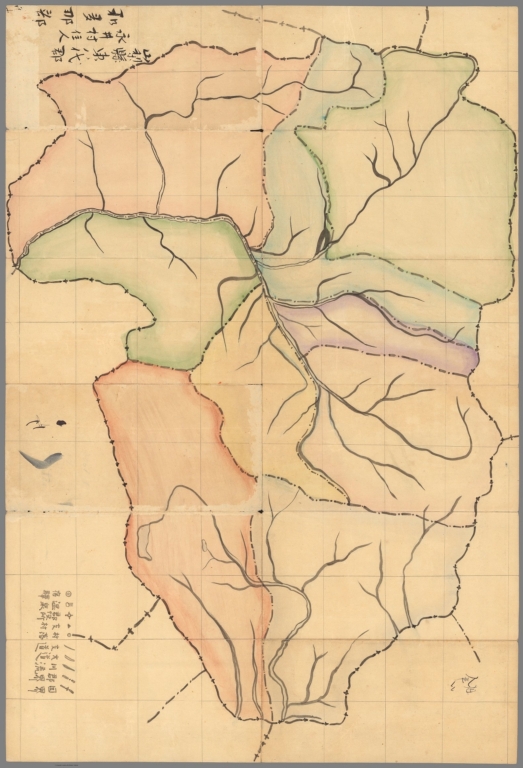
"On the verso is an unfinished manuscript map that depicts a locality, with all details unlabelled, with sub-jurisdictions outlined in the own bright hues, and a river running through it, while a legend, upper-right, defines unused symbols. We have not been able to identify the subject of the map, and even whether it pertains in any way to Taiwan. However, the note in the lower right, seems to refer to “Nagai Village”, which if true might refer to a town in the Yamagata Prefecture of north-central Japan. This is perhaps a matter for further research." (See Pub note)
Full Title:
Manuscript Map
List No:
15645.002
Series No:
2
Publication Author:
鈴木茂行 [SUZUKI Shigeyuki] (fl. 1895 - 1903)
Pub Date:
1895
Pub Title:
新撰臺灣明細全圖 [New, Complete and Detailed Map of Taiwan].
Pub Note:
"Lithograph with original wash hand colour, with contemporary manuscript notes in black pen (in Japanese) to area below title, verso featuring an unfinished coloured manuscript map of an undetermined subject, lacking the paper sleave in which it was issued Very rare – a high quality, large format Japanese map of Taiwan, issued only 6 weeks after Japan assumed control over the island from China in the wake of the First Sino-Japanese War (1894-5), predicated upon recent official sources, it was drafted by the boutique cartographer Suzuki Shigeyuki, and published in Tokyo by Kyubei Tsujimoto – a unique example bearing contemporary manuscript notes on the nature of the Japanese acquisition of Taiwan and with an unfinished coloured manuscript map of an undetermined location on the verso. Taiwan (traditionally known in the West as ‘Formosa’), is an ultra-strategically located island 180 kilometres off the southeastern coast of China. With a land area of 35,808 square kilometres, its rugged interior rises to great heights, with its tallest peak being Yu Shan, at 3,952 m (12,966 ft). The indigenous peoples of Taiwan were Austronesian tribes, and it was not until the 17th century that the island was dramatically altered by colonialism (by Spain and the Netherlands), followed the first of many waves of Han Chinese migration for the mainland. During the rule of the Qing Dynasty (1683 – 1895), the fertile plains that occupied the west coast and northern tip of the island became densely populated with Han Chinese residents and were heavily developed for agriculture. The indigenous Taiwanese were relegated to living in the island’s extremely mountainous and forested interior and along its rugged east coast, regions that collectively became known to outsiders as the ‘Savage District’. Indeed, even throughout the 19th century very few Chinese or Europeans ventured into this zone, which was still essentially controlled by its indigenous peoples, while it immense natural wonders largely remained an enigma to science. Japan had long coveted Taiwan, due to its incomparable location guarding the southern approaches to Japan and the entrance to the South China Sea, as well as its ability to grown tropical produce, and to potentially host Japanese immigrant colonies. During the early Tokugawa Shogunate, Japan mounted a few attempts to conquer Taiwan, but these endeavours were unsuccessful, placing Japan’s ambitions ‘on ice’ for generations. In 1874, Japan mounted a punitive expedition to Taiwan, in reaction to the ‘Mudan Incident’ (1871), whereby a group of native Taiwanese Paiwan people slaughtered a party of Ryukyuan sailors (whom the Japanese considered to be their subjects). While the Japanese did not conquer the island, they made a strong show of force which compelled China to renounce its claims to the disputed Ryukyu Islands, which became Japanese sovereign territory in 1879. Up to the mid-1890s, only about 45 percent of Taiwan’s landmass was effectively under Chinese control, home to around 2.3 million ethnic Han residents. The remainder of the island was inhabited by about 200,000 aboriginal peoples. While some aspects of the northern and west coasts had been scientifically surveyed, most of Taiwan was only very poorly mapped, such the island might be considered one of the least geographically understood regions of coastal Asia. Japan throttled China during the First Sino-Japanese War (1894-5), and at the Treaty of Shimonoseki (April 17, 1895) that ended the conflict, the Qing Court was compelled to cede Taiwan and the nearby Penghu Islands to Japan, even though Tokyo never mounted a significant military operation on the islands. This concession was specifically demanded by the Japanese prime minter, Prince Itō Hirobumi, as it formed the cornerstone of his ‘Southern Strategy’, whereby Japan would extend its control south to guard much of the maritime space of China, assuming dominance over the Pacific littoral of Asia from the Tropic of Cancer all the way up to the southern tip of Kamchatka. Control of Taiwan was not formally transferred to Japan until June 2, 1895. The Japanese proceeded to implement a brutal regime of military suppression (1895–1915) of both the Han Chinese and the aboriginal peoples, crushing all dissent. The Japanese occupation of Taiwan became a major rallying cry for nationalists across China who longed for revenge and to regain their lost jewel. In the months before and after the Japanese takeover of Taiwan, the geographic conception of the island underwent a revolutionary transformation. As the majority of the island had never been properly surveyed prior the arrival of the Japanese regime, many maps issued by the best Japanese publishers incorrectly showed Taiwan to assume one of many various permutations of a bulbous shape, with conjectural details occupying the ‘Savage District’. Immediately upon their arrival in Taiwan, the new Japanese regime moved with alacrity to create more accurate maps of the island, a desperate necessity, as the Japanese forces needed to plan where to deploy resources to suppress local dissent, in addition to overseeing civil governance. The Japanese gathered the best existing local survey maps from Taiwanese archives, while dispatching military engineers to make systematic scientific surveys of the island (a gruelling endeavour that would take some sears). This information gathering process led the Japanese to publish an everchanging succession of progressively more accurate maps of Taiwan, produced until the complete scientific rendering of the island was completed in the early 20th century. The Present Map in Focus The present high quality, separately issued, large format map of Taiwan is an important transitional depiction of the island, published only about 6 weeks after the Japanese formally assumed possession of Taiwan. It was drafted from officially supplied sources by Suzuki Shigeyuki [鈴木茂行] (fl. 1895 - 1903), a boutique Tokyo cartographer who made maps of Tokyo, as well a reduced version of the present work. The map was published in Tokyo by the Kyubei Tsujimoto, bearing an imprint date of July 18, Meiji 28 [1895]. The beautifully rendered and hand-coloured lithograph showcases a reasonably accurate depiction of Taiwan, even if it not scientifically precise. Gone is the former bulbous shape preferred by antebellum cartographers, as the island assumes the elongated, pointed shape familiar to the modern observer. The populous, developed west coast and northern tip of the island, long settled by the Han Chinese, is very well mapped. It is shown divided into prefectures, with numerous cities and towns labelled, with roads delineated, while depicting the line of the first railway in Taiwan, running south from Taipei, completed in 1893. Interestingly, much of the west coast is shown to be backed by a great defensive wall, built by the Chinese to protect their settlements from the indigenous tribes of the ‘Savage District’ to the east. The rugged interior features rather crudely depicted chains of high mountains, along the top of which runs the division between the ‘civilized’ part of Taiwan and the Savage District, the latter, while mapped with a broad planimetric accuracy, is shown with far less assuredness that the west and north of Taiwan. Interestingly, the present example of the map is rendered unique, due to its extensive contemporary manuscript additions. Below the title, on the righthand side of the map, is a block of text written in black ink, in Japanese, that celebrates and describes the circumstances of the Japanese takeover of the island. On the verso is an unfinished manuscript map that depicts a locality, with all details unlabelled, with sub-jurisdictions outlined in the own bright hues, and a river running through it, while a legend, upper-right, defines unused symbols. We have not been able to identify the subject of the map, and even whether it pertains in any way to Taiwan. However, the note in the lower right, seems to refer to “Nagai Village”, which if true might refer to a town in the Yamagata Prefecture of north-central Japan. This is perhaps a matter for further research. A Note on Rarity The present map is very rare. We can locate only 2 institutional examples, held by the National Diet Library (Tokyo) and the National Museum of Taiwan History (Taipei). Moreover, we cannot trace any sales records. References: National Diet Library: BC08180254; National Museum of Taiwan History: 2020.006.0108." (Alexander Johnson/Dasa Pahor, 2023)
Pub List No:
15645.000
Pub Type:
Separate Map
Pub Height cm:
78
Pub Width cm:
52
Image No:
15645002.jp2
Authors:
Anonymous