|
Author
[Geographers' Map Co, Gross, Alexander]
Full Title
(Covers to) Pictorial Map of London
List No
15898.001
Note
Date estimated.
Author
[Geographers' Map Co, Gross, Alexander]
Full Title
Pictorial Map of London
List No
15898.002
Note
Date estimated.
Author
[Geographers' Map Co, Gross, Alexander]
Full Title
Underground Railways (London Passenger Transport) of London and Suburbs.
List No
15898.003
Note
Date estimated. Map is on rear cover.
Author
[Geographers' Map Co, Gross, Alexander]
Full Title
(Text page to) Index to Streets. Pictorial Map of London
List No
15898.004
Note
Date estimated.
Author
Cape Peninsula Publicity Association
Full Title
(Covers to) Map of Cape Town
List No
15741.001
Author
Cape Peninsula Publicity Association
Full Title
Map of Cape Town
List No
15741.002
Author
Cape Peninsula Publicity Association
Full Title
(Text page to) Map of Cape Town
List No
15741.003
Author
64th Engineer Base Topographic Battalion
Full Title
City Map Central Tokyo June 1948.
List No
15745.001
Author
Pan American World Airways
Full Title
Pan American World Airways, Latin American Division. NewYork, Rio de Janeiro, Buenos Aires. Flight Map * Mapa de Rutas.
List No
12365.001
Note
Date estimated.
Author
Pan American World Airways
Full Title
(Composite Text) Pan American World Airways, Latin American Division. NewYork, Rio de Janeiro, Buenos Aires. Flight Map * Mapa de Rutas.
List No
12365.002
Note
Date estimated.
Author
Pan American World Airways
Full Title
(PAA Route Map.) New York (to) San Juan.
List No
12365.003
Note
Date estimated.
Author
Pan American World Airways
Full Title
(PAA Route Map.) San Juan (to) Port of Spain.
List No
12365.004
Note
Date estimated.
Author
Pan American World Airways
Full Title
(PAA Route Map.) Port of Spain (to) Belem.
List No
12365.005
Note
Date estimated.
Author
Pan American World Airways
Full Title
PAA Route Map.
List No
12365.006
Note
Date estimated.
Author
Pan American World Airways
Full Title
(PAA Route Map). Belem (to) Rio de Janeiro.
List No
12365.007
Note
Date estimated.
Author
Pan American World Airways
Full Title
(PAA Route Map). Rio de Janeiro (to) Buenos Aires.
List No
12365.008
Note
Date estimated.
Author
Pan American World Airways
Full Title
(Covers to) Pan American World Airways, Latin American Division. Mexico & Central America. Flight Map * Mapa de Rutas.
List No
12419.001
Note
Date estimated.
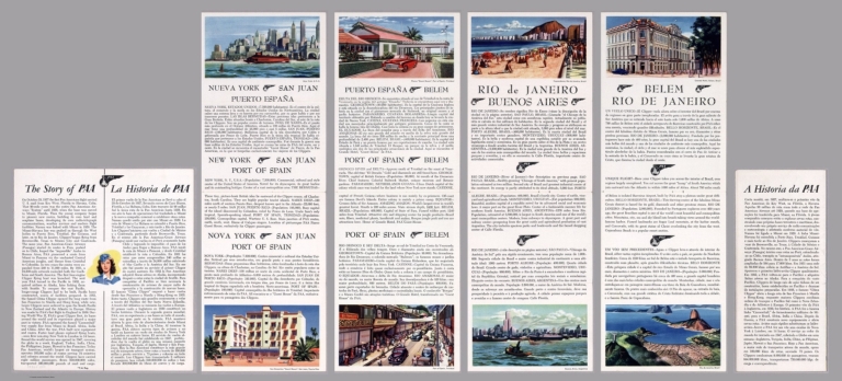
Author
Pan American World Airways
Full Title
(Text Page) The Story of PAA.
List No
12419.002
Note
Date estimated.
Author
Pan American World Airways
Full Title
Miami - Habana. Habana - Merida.
List No
12419.003
Note
Date estimated.
Author
Pan American World Airways
Full Title
New Orleans - Merida. Guatemala City.
List No
12419.004
Note
Date estimated.
Author
Pan American World Airways
Full Title
Linking the Central Americas.
List No
12419.005
Note
Date estimated.
Author
Pan American World Airways
Full Title
Houston, Mexico City, Guatemala City.
List No
12419.006
Note
Date estimated.
Author
Pan American World Airways
Full Title
Guatemala City, Panama City.
List No
12419.007
Note
Date estimated.
Author
Air France
Full Title
(Covers to) Air France.
List No
14447.001
Note
Covers to Air France : Réseau aérien mondial, folded. Front cover includes an illustration of a scene within an airplane. Printed in color.
Author
Air France
Full Title
Air France : Réseau aérien mondial.
List No
14447.002
Note
Pocket airline map of the world. Title translates to: Air France : Worldwide airline network. Shows cities, airports, air routes, bodies of water, coastlines and islands. Includes a compass rose with north oriented toward top of sheet. Text in margins: Principales agencies, Air France. Printed in color. Map is 46 x 69 cm, on sheet 49 x 89 cm.
Author
Air France
Full Title
(Text Page to) Air France.
List No
14447.003
Note
Verso to Air France : Réseau aérien mondial, unfolded. Features scenes within an airplane, as well as views of significant sites across the world. With descriptive text. Printed in color.
Author
[Reber, John, Hunt, Alex R.]
Full Title
San Francisco Bay Project, John Reber
List No
15255.000
Author
[Thailand. Krom ʻUtuniyomwitthayā, Thailand. Kō̜ngthap Rư̄a]
Full Title
Track of typhoon B. E. 2491 (A. D. 1948) : [April, May, June, July, August].
List No
14373.007
Note
Weather map of Southeast Asia, showing the tracks of typhoons and tropical depressions in April, May, June, July and August of 1948. Features names of storms. Includes latitudinal and longitudinal lines, as well as a bar scale, legend and explanatory note. Storm tracks are illustrated with black arrows, representing the directions of storms, with color-coded circles marking the location of the storm's center at 7 a.m., local time. Color-coding indicates the months in which the storms occurred; figures within circles tell the dates. Tracks are hand-drawn over photolithographed template map. Map is 31 x 40 cm, on sheet 35 x 42.
Author
[Thailand. Krom ʻUtuniyomwitthayā, Thailand. Kō̜ngthap Rư̄a]
Full Title
Track of typhoon B. E. 2491 (A. D. 1948) : [September, October, November, December].
List No
14373.008
Note
Weather map of Southeast Asia, showing the tracks of typhoons and tropical depressions in September, October, November and December of 1948. Features names of storms. Includes latitudinal and longitudinal lines, as well as a bar scale, legend and explanatory note. Storm tracks are illustrated with black arrows, representing the directions of storms, with color-coded circles marking the location of the storm's center at 7 a.m., local time. Color-coding indicates the months in which the storms occurred; figures within circles tell the dates. Tracks are hand-drawn over photolithographed template map. Map is 31 x 40 cm, on sheet 35 x 42.
Author
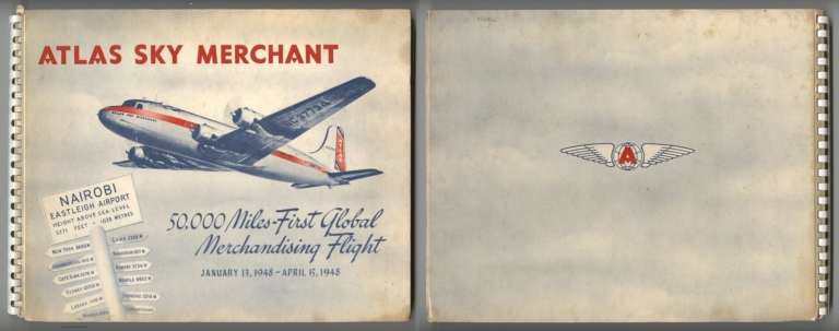
[General Drafting Co. Inc., Atlas Supply Company]
Full Title
(Covers to) Atlas Sky Merchant. 50,000 Miles - First Global Merchandising Flight. January 13, 1948 - April 15, 1948.
List No
15133.001
Author
[General Drafting Co. Inc., Atlas Supply Company]
Full Title
(Text page to) Atlas Sky Merchant. 50,000 Miles - First Global Merchandising Flight. January 13, 1948 - April 15, 1948.
List No
15133.002
Author
[General Drafting Co. Inc., Atlas Supply Company]
Full Title
(Text page to) Atlas Sky Merchant. 50,000 Miles - First Global Merchandising Flight. January 13, 1948 - April 15, 1948.
List No
15133.003
Author
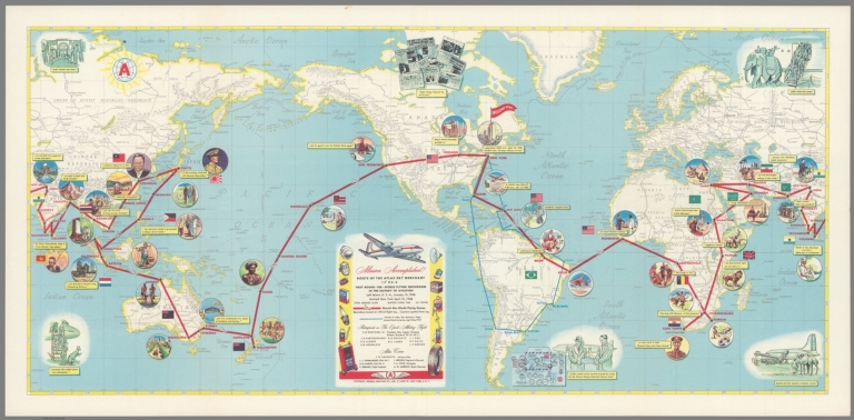
[General Drafting Co. Inc., Atlas Supply Company]
Full Title
Route of the Atlas Sky Merchant, a DC-4, first round-the-world flying showroom in the history of aviation
List No
15133.004
Author
[Portugal. Ministério das Colónias, Portugal. Junta de Investigações Coloniais]
Full Title
(Title Page to) Atlas de Portugal ultramarino e das grandes viagens Portuguesas de descobrimento e expansão / Ministério das Colónias, Junta das Missões Geográficas e de Investigações Coloniais. Lisboa ~ MCMXLVIII.
List No
14369.003
Note
Title page to Atlas de Portugal ultramarino. Title translates to: Atlas of overseas Portugal and the great Portuguese voyages of discovery and expansion. Includes imprint.
Author
[Portugal. Ministério das Colónias, Portugal. Junta de Investigações Coloniais]
Full Title
(Contents to) Índice das cartas. (1)
List No
14369.006
Note
Table of contents to Atlas de Portugal ultramarino. Lists map titles with associated page numbers. Maps appear in order of geographical and topical categories. Spans two pages.
Author
[Portugal. Ministério das Colónias, Portugal. Junta de Investigações Coloniais]
Full Title
(Contents to) Índice das cartas. (2)
List No
14369.007
Note
Table of contents to Atlas de Portugal ultramarino. Lists map titles with associated page numbers. Maps appear in order of geographical and topical categories. Spans two pages.
Author
[Portugal. Ministério das Colónias, Portugal. Junta de Investigações Coloniais]
Full Title
Distribuição geográfica do Impéro Colonial Português. Gravada e impressa no Instituto Geographico e Cadastral, em 1946. Ministério das Colónias, Junta das Missões Geográficas e de Investigações Coloniais.
List No
14369.009
Note
Map of the world, featuring the geographical distribution of the Portuguese Colonial Empire. Also shows cities, bodies of water, drainage, coastlines and islands. Includes latitudinal and longitudinal lines. Colored lithograph. Map is 32 x 54 cm, on double sheet 48 x 69 cm.
Author
[Portugal. Ministério das Colónias, Portugal. Junta de Investigações Coloniais]
Full Title
Viagens marítimas de descobrimento ao longo da costa ocidental da África. Gravada e impressa no Instituto Geographico e Cadastral, em 1946. Ministério das Colónias, Junta das Missões Geográficas e de Investigações Coloniais.
List No
14369.010
Note
Map of Africa, featuring maritime voyages of Portuguese exploration along the west coast. Also shows cities, bodies of water, drainage, coastlines and islands. Includes latitudinal and longitudinal lines, as well as explanatory notes. Colored lithograph. Map is 35 x 24 cm, on sheet 48 x 34 cm.
Author
[Portugal. Ministério das Colónias, Portugal. Junta de Investigações Coloniais]
Full Title
Viagens marítimas de descobrimento no Atlántico sul e no Mar das Índias. Gravada e impressa no Instituto Geographico e Cadastral, em 1946. Ministério das Colónias, Junta das Missões Geográficas e de Investigações Coloniais.
List No
14369.011
Note
Map of the South Atlantic and the Indian Ocean, featuring maritime voyages of Portuguese exploration. Also shows cities, bodies of water, drainage, coastlines and islands. Includes latitudinal and longitudinal lines, as well as a legend and explanatory notes. Colored lithograph. Map is 24 x 38 cm, on sheet 34 x 48 cm.
Author
[Portugal. Ministério das Colónias, Portugal. Junta de Investigações Coloniais]
Full Title
Viagens marítimas de descobrimento na América Central e Setentrional. Gravada e impressa no Instituto Geographico e Cadastral, em 1946. Ministério das Colónias, Junta das Missões Geográficas e de Investigações Coloniais.
List No
14369.012
Note
Map of Central and Northern America, featuring maritime voyages of Portuguese exploration. Also shows cities, bodies of water, drainage, coastlines and islands. Includes latitudinal and longitudinal lines, as well as a legend and explanatory notes. Colored lithograph. Map is 22 x 36 cm, on sheet 34 x 48 cm.
Author
[Portugal. Ministério das Colónias, Portugal. Junta de Investigações Coloniais]
Full Title
Viagens no extremo oriente. Gravada e impressa no Instituto Geographico e Cadastral, em 1947. Ministério das Colónias, Junta das Missões Geográficas e de Investigações Coloniais.
List No
14369.013
Note
Map of the "far east" - the Indian Subcontinent and the East Indies - featuring maritime voyages of Portuguese exploration. Also shows cities, bodies of water, drainage, coastlines and islands. Includes latitudinal and longitudinal lines, as well as a legend and explanatory notes. Colored lithograph. Map is 22 x 36 cm, on sheet 34 x 48 cm.
Author
[Portugal. Ministério das Colónias, Portugal. Junta de Investigações Coloniais]
Full Title
Pretensas viagens pelo norte do velho e novo mundo. Gravada e impressa no Instituto Geographico e Cadastral, em 1947. Ministério das Colónias, Junta das Missões Geográficas e de Investigações Coloniais.
List No
14369.014
Note
Map of the world, featuring maritime voyages of Portuguese exploration in the Northern Hemisphere. Also shows cities, bodies of water, drainage, coastlines and islands. Includes latitudinal and longitudinal lines, as well as explanatory notes. Colored lithograph. Map is 18 x 28 cm, on sheet 34 x 48 cm.
Author
[Portugal. Ministério das Colónias, Portugal. Junta de Investigações Coloniais]
Full Title
Esboço dos itinerários de Fernão Mendes Pinto, roteiro das viagens de Fernão de Magalhães, Pedro Fernandes Queirós e das príncipais da Índia a Portugal por via terrestre e marítima. Gravada e impressa no Instituto Geographico e Cadastral, em 1947. Ministério das Colónias, Junta das Missões Geográficas e de Investigações Coloniais.
List No
14369.015
Note
Map of the world, featuring the itineraries for maritime voyages of Portuguese exploration by Fernão Mendes Pinto, Fernão de Magalhães and Pedro Fernandes Queirós. Also shows the main cities from Portugal to India by land and sea, as well as bodies of water, drainage, coastlines and islands. Includes latitudinal and longitudinal lines, as well as a legend. Colored lithograph. Map is 30 x 50 cm, on double sheet 48 x 69 cm.
Author
[Portugal. Ministério das Colónias, Portugal. Junta de Investigações Coloniais]
Full Title
Mapa das principais viagens de penetração e exploração no contenente Africano realizadas pelos Portugueses, do século XV ao século XIX. Gravada e impressa no Instituto Geographico e Cadastral, em 1946. Ministério das Colónias, Junta das Missões Geográficas e de Investigações Coloniais.
List No
14369.016
Note
Map of Africa, featuring Portuguese exploration, from the fifteenth to the nineteenth centuries. Also shows cities, bodies of water, drainage, coastlines and islands. Includes latitudinal and longitudinal lines, as well as a legend and explanatory notes. Colored lithograph. Map is 48 x 37 cm, on double sheet 69 x 48 cm. With handwritten annotations in bottom margin.
Author
[Portugal. Ministério das Colónias, Portugal. Junta de Investigações Coloniais]
Full Title
Explorações Portugueses do continente sul Americao, no século XVI. Gravada e impressa no Instituto Geographico e Cadastral, em 1948. Ministério das Colónias, Junta das Missões Geográficas e de Investigações Coloniais.
List No
14369.017
Note
Map of South America, featuring Portuguese exploration in the sixteenth century. Also shows cities, bodies of water, drainage, coastlines and islands. Includes latitudinal and longitudinal lines, as well as a legend and explanatory notes. Map indexed to indicate areas explored during different voyages. Colored lithograph. Map is 38 x 26 cm, on sheet 48 x 34 cm.
Author
[Portugal. Ministério das Colónias, Portugal. Junta de Investigações Coloniais]
Full Title
Explorações Portugueses do continente sul Americao, no século XVII. Gravada e impressa no Instituto Geographico e Cadastral, em 1948. Ministério das Colónias, Junta das Missões Geográficas e de Investigações Coloniais.
List No
14369.018
Note
Map of South America, featuring Portuguese exploration in the seventeenth century. Also shows cities, bodies of water, drainage, coastlines and islands. Includes latitudinal and longitudinal lines, as well as a legend and explanatory notes. Map indexed to indicate areas explored during different voyages. Colored lithograph. Map is 38 x 26 cm, on sheet 48 x 34 cm.
Author
[Portugal. Ministério das Colónias, Portugal. Junta de Investigações Coloniais]
Full Title
Carta demográfica do Impéro Colonial Português. Gravada e impressa no Instituto Geographico e Cadastral, em 1946. Ministério das Colónias, Junta das Missões Geográficas e de Investigações Coloniais.
List No
14369.019
Note
Map of the world, featuring the demographics of the Portuguese Colonial Empire. Also shows cities, bodies of water, drainage, coastlines and islands. Includes latitudinal and longitudinal lines, as well as a legend and explanatory notes. With statistical table: População do Império Português [= Population of the Portuguese Empire]. Colored lithograph. Map is 22 x 34 cm, on sheet 34 x 48 cm.
Author
[Portugal. Ministério das Colónias, Portugal. Junta de Investigações Coloniais]
Full Title
Carta das linhas férreas e aéreas de Angola e Moçambique e suas principais ligações com as colónias limítrofes. Gravada e impressa no Instituto Geographico e Cadastral, em 1945. Ministério das Colónias, Junta das Missões Geográficas e de Investigações Coloniais, Outubro de 1940.
List No
14369.020
Note
Map of southern Africa, featuring railways and air lines of Angola and Mozambique, with their main connections to the neighboring nations. Also shows political boundaries, cities, bodies of water, drainage, coastlines and islands. Includes latitudinal and longitudinal lines, as well as a legend and bar scale. Colored lithograph. Map is 36 x 52 cm, on double sheet 48 x 69 cm.
Author
[Portugal. Ministério das Colónias, Portugal. Junta de Investigações Coloniais]
Full Title
Carta hipsométrica de África e regiões limítrofes. Gravada e impressa no Instituto Geographico e Cadastral, em 1944. Ministério das Colónias, Junta das Missões Geográficas e de Investigações Coloniais, Outubro de 1940.
List No
14369.021
Note
Map of Africa, featuring elevation. Relief shown with color coding. Also shows cities, bodies of water, drainage, coastlines and islands. Includes latitudinal and longitudinal lines, as well as a legend and bar scale. Colored lithograph. Map is 30 x 25 cm, on sheet 48 x 34 cm.
Author
[Portugal. Ministério das Colónias, Portugal. Junta de Investigações Coloniais]
Full Title
Arquipélago de Cabo Verde. Gravada e impressa no Instituto Geographico e Cadastral, em 1944. Ministério das Colónias, Junta das Missões Geográficas e de Investigações Coloniais, Outubro de 1940.
List No
14369.022
Note
Map of the Cape Verde Archipelago, as a Portuguese colony. Shows cities, roads, bodies of water, drainage, coastlines and islands. Relief shown with contour lines. Includes latitudinal and longitudinal lines, as well as a legend, bar scale and scale statement. Colored lithograph. Map is 39 x 53 cm, on double sheet 48 x 69 cm.
|


![Track of typhoon B. E. 2491 (A. D. 1948) : [April, May, June, July, August].](https://www.davidrumsey.com/rumsey/Size2/RUMSEY~8~1/199/14373007.jpg)
![Track of typhoon B. E. 2491 (A. D. 1948) : [September, October, November, December].](https://www.davidrumsey.com/rumsey/Size2/RUMSEY~8~1/199/14373008.jpg)