Author
Bowen, Emanuel
Full Title
A new & accurate map of the North Pole, with all the countries hitherto discovered situated near or adjacent to it, as well as some others more remote. Drawn from the latest and best authorities and regulated by astronoml. observatns. By Eman. Bowen. (London: Printed for William Innys, Richard Ware, Aaron Ward, J. and P. Knapton, John Clarke, T. Longman and T. Shewell, Thomas Osborne, Henry Whitridge ... M.DCC.XLVII)
List No
3733.069
Note
Engraved map. Includes geographic notes and ornamental cartouche. Relief shown pictorially.
Author
Jefferys, Thomas
Full Title
(Engraved title page to) The West-India atlas: or, a compendious description of the West-Indies: illustrated with forty one correct charts and maps, taken From actual surveys. Together with an historical account of the several countries and islands which compose that part of the world. By the late Thomas Jefferys, Geographer to the King. London: Printed for Robert Sayer and John Bennett, Map, Chart, Print-Sellers, and Globe Makers, Fleet-Street, M,DCC,LXXXIII.
List No
4723B
Note
This is a superb atlas of the West Indies and a companion atlas to Jeffery's American Atlas also first issued in 1775. The latest date on the charts in this copy is 1788 (The Cape Verd Islands). There is a beautifully illustrated title page that precedes the main title page, which reads "The West Indian Atlas..." Jefferys died in 1771; Sayer and Bennet acquired his materials in preparation for this atlas, and published the atlas posthumously under his name (as they did with the American Atlas) in 1775. The heart of this atlas and the most detailed part is the sixteen sheet large chart and index sheet of the whole of the West Indies. The rest of the atlas consists of charts of the Atlantic Islands and the British Channel, as well as individual maps and charts of seventeen islands in the West Indies. Twenty seven pages of text gives the sources for the maps and charts, and a historical account of the West Indies. Three of the large chart maps also appeared in the American Atlas. Comparing the two Florida sheets in this atlas to the same sheets in the 1775 American Atlas, numerous changes to the coast lines and other features appear. That would indicate that Sayer updated the charts as the atlas was reissued - Phillips shows issues of 1775, 1781, 1787, 1794, 1796, 1807, and 1818. With the 1794 and later editions, 20 maps are added of various additional islands. Sayer and Bennet also published in 1775 a smaller version of this atlas called "The West India Islands: From Actual Survey and Observations..." that consisted of the same text, a general chart of the Islands, and the same sixteen or seventeen (depending on the edition) charts of the islands that appear in the larger version (P3942). Finally, Jefferys himself published in 1762 "A Description of the Spanish Islands and Settlements on the Coast of the West Indies" which was issued in quarto, with a general chart and 32 maps and plans of harbors and towns (P3941).
Author
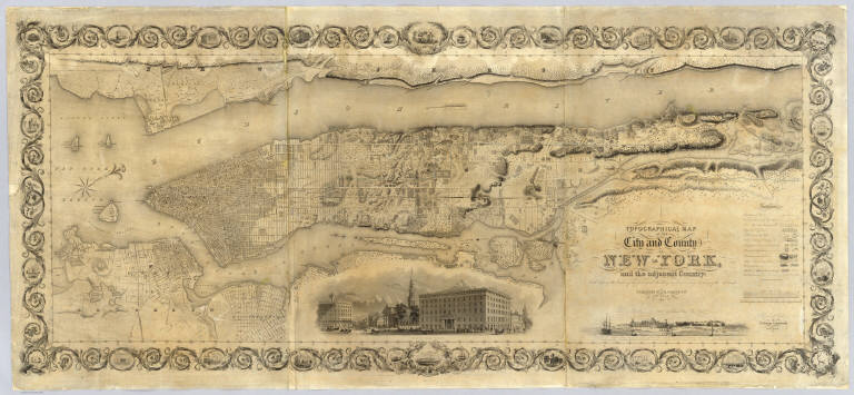
Colton, J. H.
Full Title
Topographical Map Of The City and County Of New - York, and the adjacent Country: With Views in the border of the principal Buildings and interesting Scenery of the Island. Published By J.H. Colton & Co. No. 4 Spruce St. New-York. 1836. Engraved & Printed by S. Stiles & Company, New-York. Entered ... 1836, by J.H. Colton & Co. ... New York.
List No
2784.000
Note
1st ed., 2nd state. Stokes: "This is one of the most beautiful nineteenth century plans or maps of Manhattan Island, and is full of interesting information, It is perhaps the last example of really artistic map-making, as applied to Manhattan Island." Ristow believes that Burr may have drawn this map based on similarities between it and the Burr New York City map that appeared in Burr's New York State Atlas of 1829. Accompanied by the "Summary History.." Stokes describes his copy of the 1st edition as not listing Madison Square and some other differences between the 1836 and 1841 editions which would lead one to conclude that this copy is slightly later than 1836 (it shows Madison Square which was established in 1837) - apparently an unrecorded 2nd state of the first edition. Without color or top and bottom rollers.
Author
[Beasley, T.D., Taylor, Jas. T.]
Full Title
Oahu, Hawaiian Islands. Compiled from Maps of Government Surveys and other reliable sources. Drawn by T.D. Beasley under supervision of Jas. T. Taylor, M. Am. Soc. C.E. November, 1899. United States, Copyright by Jas. T. Taylor 1899. Lith. Britton & Rey, S.F., Cal.
List No
3707.000
Note
Detailed, large scale map of Oahu made the year of annexation by the U.S. Shows lots and plantation names, topography, and town layouts. In full color. Relief shown by hachures and spot heights. Printed on 2 sheets. David Rumsey Collection copy mounted as one sheet; belonged to Michael M. O'Shaughnessy (deduced from ms "Oahu, Hawaii" in his hand), the famous California engineer (see 1881 Oahu map - our 3706); imprint cropped off.
Author
Haasis & Lubrecht
Full Title
The American Union Railroad Map Of The United States, British Possessions, West Indies, Mexico, And Central America. 1871. Published by Haasis & Lubrecht, 107 Liberty Street, New York. Smith & McDougal, Electrotypers, 82 Beekman Street, New York. (inset) Central America.
List No
3822.000
Note
This is a reworking of the Lubrecht and Rosa map "The American Continent" of 1864, and the first edition, first issue in a new format. Statistics at the top of the 1864 map are here replaced with a view "From the Atlantic to the Pacific Ocean" emphasizing the recently completed transcontinental railroad. Also, an elaborate title and view of a steam engine and train station have replaced the more subdued 1864 title. Population tables of the United States are added to the left and right sides of the map. The map itself has been updated to show political and some topographical changes of the ensuing seven years. Projected railroad lines are shown running everywhere in the west. The coloring is very bright, to match the decidedly optimistic (expansionist) flavor of the map. D.L. Guernsey published editions of 1871 and 1874 in Concord New Hampshire, with no major changes in the map. WH has an 1873 edition by Haasis and Lubrecht that adds text next to the population figures, more railroads, no changes in topography. Issued in a cover with a label in German from Wilhelm Lubrecht in Stuttgart, Germany, indicating it may have been sold to emigrants. Full color. Map has green paper edging, is dissected into 16 sections, and fold into a new gray cloth folding case 35x27 with "American Union Railroad Map Haasis & Lubrecht 1871" stamped in gilt on the spine.
Author
[California. Office of State Engineer, Hall, Wm. Ham. (William Hammond)]
Full Title
Los Angeles & San Bernardino topography. Wm. H. Hall, State Engineer, Sacramento. (circa 1880)
List No
3451.000
Note
Beautiful hand drawn map of the Los Angles-San Bernardino Basin. Pen-and-ink and pencil. Relief shown by hachures. It appears to be a base map on a scale of two miles to an inch, probably preliminary (several of Hall's notations on the edges indicate corrections needed to the topography) and earlier than the 1888 Report titled "Irrigation in California" that had 15 maps that may have been derived from this map. It may also have served as the base for "Drainage area map to accompany report on irrigation and water supply in California" by Wm. Ham. Hall, State Engineer. (188-?). Hall was a famous engineer who was the first state engineer and was responsible for many of the early state water projects (see California Water Atlas). This map does not have any names drawn in except for a few towns, rivers, or railroads lightly penciled in. All the land divisions and city plats are indicated, with mountains, rivers, railroads, roads, arroyos and shorelines shown. Hall also published four maps of the San Joaquin Valley in 1886 (see WH's copy) separately (see Calfornia Water Atlas p.26). "VI." Title and cartographer from verso. "14" on verso.
Author
Hayes, Eli L.
Full Title
Glass works of J.H. Hobbs, Brockunier & Co. ... Wheeling, West, Va. (... compiled & drawn for the publishers by E.L. Hayes, assisted by E.F. Hayes, C.M. Beresford, assisted by S.A. Charpiot, F.L. Sanford, J.H. Sherman. Published by Titus, Simmons & Titus ... Phila. 1877 ... Printed by H.J. Toudy & Co. ... Oldach & Mergenthaler Binders ...)
List No
4975.086
Note
Lithograph. External and internal views.
Author
Dunn, Samuel
Full Title
(Composite of) A general map of the world or terraqueous globe; with all the new discoveries and marginal delineations, containing the most interesting particulars in the solar, starry and mundane systems. By Saml. Dunn, Mathematician. London: printed for Rt. Sayer, Map, Chart and Printseller, 53 Fleet Street, 1787.
List No
0411.003
Note
Engraved map on 4 sheets. Continent boundaries in outline color. Shows explorers' tracks. Relief shown pictorially. Includes ancillary maps, charts and drawings of the solar system, the northern and southern hemispheres of the celestial globe, "An astronimical latitude & longitude analemma," "A chart of the world according to Mercator's projection with the Rhumb lines," "Selenography or a map of the Moon according to Father Riccioli," "The vicissitude of seasons explained," "The Analemma," two drawings entitled "The art of dialing by a common globe," "A Universal scale," and text. David Rumsey Collection copy has the 4 sheets mounted as 2. Small portion at top cropped off. (W 180--E 180/N 90--S 90)
Author
[Robert de Vaugondy, Didier, 1723-1786, Robert de Vaugondy, Gilles, 1688-1766]
Full Title
Mappemonde ou description du globe terrestre; dressee sur les memoires les plus nouveaux, et assujettie aux observations astronomiques, Par le Sr. Robert de Vaugondy, fils. A Paris, Chez Les Srs. Robert Geoges. ordes. du Roy, Quay de l'Horloge du Palais, Ante. Boudet Libraire-Imprimr. du Roy, rue St. Jacques. Avec Privilege 1752. C. Cochin filius delin. P.F. Tardieu sculp.
List No
3353.013
Note
Engraved double hemisphere map. Hand col. borders. Relief shown pictorially. Shows routes of Anson, l'Aigle de la Marie, Galion Na. Seignora. Ornamental cartouches.
Author
[Gray, R., Wilkinson, Robert]
Full Title
North America from the most authentic and latest surveys. R. Gray Sculpt. Glasgow, 1811.
List No
1204.000
Note
This is a copy of the 1804 Wilkinson North America map, here printed on linen. Very Scarce. Wilkinson's map of 1804 has been somewhat simplified to allow for limited detail due to printing on fabric. See our #5156 for the Wilkinson 1804 map (see also our copy of the 1826 reissue of Wilkinson's map which appears to be unchanged from the 1804 issue). With a decorative border of vines and tiny vignettes. John Faupel suggested this was probably made as a "commemorative" piece in a very small issue.
Author
Garnier, F. A., 1803-1863
Full Title
Amerique du Nord spheroidale. Atlas spheroidal & universel de geographie dresse par F.A. Garnier, geographe. Paris, Ve. Jules Renouard, Editeur, Rue de Tournon, no. 6, Fg. St. Gin. 1860. Imp. Sarazin, r. Git-le-Coeur, 8.
List No
5023.018
Note
Full col. Relief shown hachures. Prime meridian: Paris. On globe in cartouche: Sphericite de la terre.
Author
[Andreas, A. T. (Alfred Theodore), 1839-1900, Ellsbury, Geo. H.]
Full Title
Minneapolis, Minn. Hoffman (lithographer). Chas. Shober & Co., Proprietors of Chicago Lith. Co. Entered, according to act of Congress, year A.D. 1874, by Geo. H. Ellsbury and V. Green ... (Published by A.T. Andreas, Lakeside Building, Chicago)
List No
3034.024
Note
Col. lithograph. Panoramic view.
|