Who What Where WhenWHATShow MoreWHO
WHEN
|
Author
Cram, George Franklin, 1841-1928
Full Title
Chart of the world showing distances saved by the Interoceanic Canal, of Nicaragua and Costa Rica.
List No
14372.361
Note
Map of the world showing the Interoceanic Canal [Nicaraguan Canal], of Nicaragua and Costa Rica. Shows cities, topography, bodies of water, drainage, coastlines, islands and water routes with distances. Relief shown with hachures. Includes a legend, as well as latitudinal and longitudinal lines. Inset map: [Nicaragua]. With table: Table showing distances in miles between commercial ports of the world and distances saved by the Nicaragua Canal. Colored lithograph. Map is 25 x 40 cm, on sheet 33 x 45 cm.
Author
Dépôt General de la Marine
Full Title
(Covers to) [French composite sea atlas focusing on colonization in Southeast Asia].
List No
14392.001
Note
Covers to [French composite sea atlas focusing on colonization in Southeast Asia]. Large folio bound in black-and-pink speckled board with contemporary red roan spine. Gilt ornamentation on spine.
Author
Dépôt General de la Marine
Full Title
Hémisphère austral -- Hémisphère boréal -- [Mars ... Avril].
List No
14392.002
Note
Three celestial maps. Two round maps show the stars and constellations visible from the southern and northern hemispheres. The panoramic map below shows the stars visible throughout all the months of the year, beginning with March. Includes a legend and explanatory text. Diagram at bottom illustrates the difference in size between the planets. Black and white engraving. Together, maps are 55 x 71 cm, on double sheet 60 x 86 cm. (Date inferred.)
Author
[Dépôt General de la Marine, Gressier, Charles-Louis, 1791-1886]
Full Title
Carte hydrographique des parties connues de la terre dressée la Projection de Mercater, par C. L. Gressier, Ingénieur Hydrographe de la Marine. Publiée par Ordre du Roi sous le Ministère de M. le Baron Duperré, Amiral, Pair de France, Secrétaire d'Etat au Département de la Marine et des Colonies. Au Dépôt-général de la Marine en 1835. Gravé par Michel. Ecrit par J. M. Hacq.
List No
14392.003
Note
Nautical chart of the world, as of 1835. Shows continents, countries, cities, ports, deserts, bodies of water, drainage, coastlines, shoals and islands. Includes latitudinal and longitudinal lines, as well as explanatory text. Seal: Dépôt Général de la Marine. Black and white engraving. Map is 57 x 86 cm, on double sheet 65 x 93 cm. Published by Order of the King under the Ministry of M. le Baron Duperré, Admiral, Peer of France, Secretary of State in the Department of the Navy and the Colonies, at the General Depot of the Navy in 1835. "No. 818."
Author
[Dépôt General de la Marine, Daussy, Pierre, 1792-1860, Jacob]
Full Title
Carte de l'Océan Atlantique Septentrional (depuis l'Equateur jusqu'au 52 ème degré de Latitude). Rédigée par P. Daussy Ingénieur Hydrographe en chef de la Marine. Publiée par Ordre du Roi sous le Ministère de M. le Comte Jacob, Vice Admiral, Pair de France, Secrétaire d'Etat au Département de la Marine et des Colonies. Au Dépôt-général de la Marine en 1834. Gravé par Michel. Ecrit par J. M. Hacq.
List No
14392.004
Note
Nautical chart of the North Atlantic Ocean, from the Equator to the 52nd degree of latitude, surveyed in 1834. Shows countries, cities, ports, deserts, bodies of water, drainage, coastlines, shoals, islands, depths and anchorage. Features hand-drawn annotations in colored pencil, tracing voyages, labeled with dates. Colors represent different ships: Isère (solid red line), Voltigeur (dashed red line), and Cléopâtre (blue line). Includes rhumb lines, latitudinal and longitudinal lines, as well as exP. Daussy Chief Hydrographic Engineer of the Navy. Published by Order of the King under the Ministry of M. le Comte Jacob, Vice Admiral, Peer of France, Secretary of State in the Department of the Navy and the Colonies, at the General Depot of the Navy in 1834. "No. 800."
Author
Dépôt General de la Marine
Full Title
Carte réduite de La Manche. Dressée pour le Service des Vaisseaux Français par Ordre du Ministre de la Marine au Dépôt Général des Cartes et Plans de la Marine et des Colonies en 1798. Nouvelle Edition de l'An 1802, corrigée et augmentée.
List No
14392.005
Note
Nautical chart of the English Channel, first surveyed in 1798, and updated in 1802. Shows countries, cities, ports, bodies of water, drainage, coastlines, shoals, islands, depths and anchorage. Includes rhumb lines, latitudinal and longitudinal lines, as well as explanatory text and notes throughout. Seal: Dépôt Gal. de la Marine. Black and white engraving. Map is 53 x 88 cm, on double sheet 62 x 96 cm. Created for the Service of French Vessels by Order of the Minister of the Navy at the General Depot of Maps and Plans of the Navy and the Colonies in 1798. New edition of the year 1802, corrected and increased. "No. 85."
Author
Dépôt General de la Marine
Full Title
Plan de l'Embouchure de la Seine (environs du Havre) levé en 1834. Par les Ingénieurs Hydrographes de la Marine, sous les Ordres de l'Academie Royale des Sciences et du Bureau des Longitudes. Publié par Ordre du Roi sous le Ministère de M. le Baron Tupinier, Secrétaire d'Etat au Département de la Marine et des Colonies. Au Dépôt-général de la Marine en 1839. Gravé par C. E. Collin. Ecrit par J. M. Hacq.
List No
14392.006
Note
Nautical chart of the mouth of the Seine River, France, surveyed in 1834. Shows cities, ports, roads, topography, vegetation, bodies of water, drainage, shorelines, shoals, islands, depths and anchorage. Relief shown with hachures. Includes a legend, two bar scales and compass rose with north oriented toward upper left of sheet, as well as explanatory text. Seal: Dépôt Général de la Marine. Black and white engraving. Map is 95 x 60 cm, on double sheet 97 x 64 cm. Created by the Hydrographic Engineers of the Navy, under the orders of the Royal Academy of Sciences and the Bureau des Longitudes. Published by Order of the King under the Minister of M. le Baron Tupinier, Secretary of State in the Department of the Navy and the Colonies, at the Depot-General of the Navy in 1839. "No. 892."
Author
[Dépôt General de la Marine, Le Saulnier de Vauhello, Hippolyte, 1796-1858, Wissocq, Cazeaux, Darondeau]
Full Title
Carte générale des sondes d'attérages des Côtes Occidentales de France et des Côtes Septentrionales d'Espagne faites, en 1828 et 1829. Par M. le Saulnier de Vauhello, Lieutentant de Vaisseau, Chevalier de la Légion d'Honneur, Commandant des Bricks la Badine et l'Alsacienne, assisté de M. M. Wissocq, Cazeaux et Darondeau, Ingénieurs Hydrographes de la Marine et de A. Jehenne, Lieutentant de Vaisseau. Publié par Ordre du Roi sous le Ministère de M. le Comte de Rigny, Vice-Amiral, Secrétaire d'Etat au Département de la Marine et des Colonies. Au Dépôt-général de la Marine en 1832. Gravé par Michel. Ecrit par Hacq.
List No
14392.007
Note
Nautical chart of the landfall soundings of the western coast of France and the northern coast of Spain, surveyed in 1828 and 1829. Shows cities, ports, roads, topography, bodies of water, drainage, coastlines, shoals, islands, depths and anchorage. Relief shown with hachures. Includes a rhumb lines, latitudinal and longitudinal lines, compasses roses with north oriented toward upper left of sheet, as well as explanatory text. Seal: Dépôt Général de la Marine. Black and white engraving. Map is 56 x 89 cm, on double sheet 63 x 96 cm. Created by M. le Saulnier de Vauhello, Lieutentant de Vaisseau, Chevalier de la Légion d'Honneur ... assisted by M. M. Wissocq, Cazeaux and Darondeau, Hydrographic Engineers of the Navy, and by A. Jehenne, Lieutentant de Vaisseau. Published by Order of the King under the Ministry of M. le Comte de Rigny, Vice-Admiral, Secretary of State in the Department of the Navy and the Colonies, at the Depot-General of the Navy in 1832. "No. 86."
Author
[Dépôt General de la Marine, Beautemps Beaupré, Charles François, 1766-1854]
Full Title
Carte des Côtes de France (environs de Brest) levée en 1816, 1817 et 1818. Par les Ingénieurs Hydrographes de la Marine, sous les Ordres de M. Beautemps-Beaupré Ingénieur Hydrographe en Chef, Membre de l'Académie Royale des Sciences de l'Institut de France et de la Societé Royale des Sciences de Gællingen. Publiée par Ordre du Roi sous le Ministère de son Excellence M. le Marquis de Clermont-Tonnerre. Pair de France, Secrétaire d'Etat an Département de la Marine et des Colonies. Au Dépôt-général de la Marine en 1825. Gravé par E. Collin. Ecrit par Besançon.
List No
14392.008
Note
Nautical chart of the coast in the vicinity of Brest, France, surveyed in 1816, 1817 and 1818. Shows cities, ports, topography, bodies of water, drainage, coastlines, shoals, islands, depths and anchorage. Relief shown with hachures. Includes a legend, rhumb lines, latitudinal and longitudinal lines, as well as explanatory text. Seal: Dépôt Général de la Marine. Black and white engraving. Map is 57 x 86 cm, on double sheet 62 x 93 cm. Created by the Hydrographic Engineers of the Navy, under the Orders of Beautemps-Beaupré, Chief Hydrographic Engineer, Member of the Royal Academy of Sciences of the Institut de France and the Royal Society of Sciences of Gællingen. Published by Order of the King under the Ministry of His Excellency M. le Marquis de Clermont-Tonnerre, Peer of France,Secretary of State in the Department of the Navy and the Colonies, at the Depot-General of the Navy in 1825. "No. 104."
Author
[Dépôt General de la Marine, Beautemps Beaupré, Charles François, 1766-1854]
Full Title
Carte particuliêre des Côtes de France (entrée de la Rade de Brest et partie méridionale du Chenal du Four) levée en 1816 et 1818. Par les Ingénieurs Hydrographes de la Marine, sous les Ordres de M. Beautemps-Beaupré Ingénieur Hydrographe en Chef, Membre de l'Académie Royale des Sciences de l'Institut de France et de la Societé Royale des Sciences de Gællingen. Publiée par Ordre du Roi sous le Ministère de son Excellence M. le Marquis de Clermont-Tonnerre. Pair de France, Secrétaire d'Etat an Département de la Marine et des Colonies. Au Dépôt-général de la Marine en 1822. Gravé par E. Collin. Ecrit par Besançon.
List No
14392.009
Note
Nautical chart of the coast in the vicinity of Rade de Brest and the southern part of the Chenal du Four, France, surveyed in 1816 and 1818. Shows cities, ports, topography, vegetation, bodies of water, drainage, coastlines, shoals, islands, depths and anchorage. Relief shown with hachures. Includes a legend, rhumb lines, latitudinal and longitudinal lines, as well as explanatory text and notes throughout. Seal: Dépôt Général de la Marine. Black and white engraving. Map is 57 x 86 cm, on double sheet 62 x 93 cm. Created by the Hydrographic Engineers of the Navy, under the Orders of Beautemps-Beaupré, Chief Hydrographic Engineer, Member of the Royal Academy of Sciences of the Institut de France and the Royal Society of Sciences of Gællingen. Published by Order of the King under the Ministry of His Excellency M. le Marquis de Clermont-Tonnerre, Peer of France, Secretary of State in the Department of the Navy and the Colonies, at the Depot-General of the Navy in 1825. "No. 106."
Author
[Dépôt General de la Marine, Beautemps Beaupré, Charles François, 1766-1854]
Full Title
Carte particuliêre des Côtes de France (Rade de Brest et Baie de Douarnenez) levée en 1816 et 1817. Par les Ingénieurs Hydrographes de la Marine, sous les Ordres de M. Beautemps-Beaupré Ingénieur Hydrographe en Chef, Membre de l'Académie Royale des Sciences de l'Institut de France et de la Societé Royale des Sciences de Gællingen. Publiée par Ordre du Roi sous le Ministère de son Excellence M. le Marquis de Clermont-Tonnerre. Pair de France, Secrétaire d'Etat an Département de la Marine et des Colonies. Au Dépôt-général de la Marine en 1825. Gravé par E. Collin. Ecrit par Besançon.
List No
14392.010
Note
Nautical chart of the coast in the vicinity of Rade de Brest and the Bay of Douarnenez, France, surveyed in 1816 and 1817. Shows cities, ports, topography, vegetation, bodies of water, drainage, coastlines, shoals, islands, depths and anchorage. Relief shown with hachures. Includes a legend, rhumb lines, latitudinal and longitudinal lines, as well as explanatory text. Seal: Dépôt Général de la Marine. Black and white engraving. Map is 86 x 57 cm, on double sheet 90 x 62 cm. Created by the Hydrographic Engineers of the Navy, under the Orders of Beautemps-Beaupré, Chief Hydrographic Engineer, Member of the Royal Academy of Sciences of the Institut de France and the Royal Society of Sciences of Gællingen. Published by Order of the King under the Ministry of His Excellency M. le Marquis de Clermont-Tonnerre, Peer of France, Secretary of State in the Department of the Navy and the Colonies, at the Depot-General of the Navy in 1825. "No. 113."
Author
[Dépôt General de la Marine, Ciera, Miguel António, active 18th century, Franzini, Marino Miguel, 1779-1861]
Full Title
Carte réduite de la Côte de Portugal depuis le Cap Silleiro jusqu'à la Barre de Huelba avec les Plans particuliers des principaux Ports. Dressée d'après les Opérations Trigonométriques de M. Ciera Astronome et les nouvelles Cartes Portugaises contruites en 1811 par M. Franzini Major du Corps Royaldes Ingénieurs. Publiée par Ordre du Roi sous le Ministère de M. le Vicomte Dubouchage Ministre de la Marine et des Colonies. Au Dépôt-général de la Marine en 1816. Gravé par E. Collin. Ecrit par Besançon.
List No
14392.011
Note
Nautical chart of the coast of Portugal from Cape Silleiro to the Bar of Huelba [Huelva], surveyed in 1811. Shows cities, ports, topography, bodies of water, drainage, coastlines, shoals, islands, depths and anchorage. Relief shown with hachures. Includes rhumb lines, latitudinal and longitudinal lines, as well as an explanatory notes. With nine inset maps: Plan des Roches Leichoés -- Entrée du Douro -- Plan de la Vouv. le Barre de Aveiro -- Plan de la Barre de Figueira -- Plan de l'Anse de S. Martinho -- Carte réduite comprenant la Presqu'île de Peniche et les Îles Berlingues -- Plan de la Baie de Setuval -- Plan de la Baie de Lagos -- Plan de la Baie de Va. Na. de Portimaon à la Côte d'Algarve. Seal: Dépôt Gal. de la Marine. Black and white engraving. Map is 88 x 57 cm, on double sheet 95 x 64 cm. Created according to the Trigonometric Operations of Ciera, Astronomer, and the new Portuguese Maps drawn in 1811 by Franzini, Major of the Royal Corps of Engineers. Published by Order of the King under the Ministry of M. le Viscount Dubouchage, Minister of the Navy and the Colonies, at the Depot-General of the Navy in 1816. "No. 197."
Author
[Dépôt General de la Marine, Luyando, José de, 1773-1835, Sánchez Cerquero, Vicente]
Full Title
Carte Esferica del Esterecho de Gibraltar construida segun los metodos más exâctos en 1820, por Dn. José Luyando; con el reconocimiento, situacion y sonda de los Cabezos que de Rl. Orn. ha practicado en 1825 el Teniente de Navio Dn. Vicete Sanchez Cerquero: publicado por la Direccion Hidrografica y presentada al Rey Nuestra Señor por el Exmo. Señor Dn. Luis Maria de Salazar consejero de Estado y Secretario de Estado y del Despacho Universal de Marina. Año de 1826. R. Esteve la gro. Mo. Co. Maré gro. la letra.
List No
14392.012
Note
Nautical chart of the Strait of Gibraltar, surveyed in 1820. Shows cities, ports, topography, vegetation, bodies of water, drainage, coastlines, shoals, islands, depths and anchorage. Relief shown with hachures. Includes latitudinal and longitudinal lines, as well as an explanatory notes. With two inset maps: Plano de la bahia de Tanger -- Plano de los bajos de los Cabezos. Also, with profile views. Seal: Direccion Hidrografica Precio 20. R.V. Black and white engraving. Map is 83 x 52 cm, on double sheet 90 x 59 cm. Created by Dn. Jose Luyando. Published by the Hydrographic Directorate and presented to the King by Señior Dan. Luis Maria de Salazar, Counselor of State and Secretary of State of the Universal Office of the Navy in 1826.
Author
[Dépôt General de la Marine, Gautier, Benoist]
Full Title
Carte réduite de la Mer Méditerranée et de la Mer Noire. Assujettie aux Observations faites en 1816, 1817, 1818, 1819 et 1820, par M. Gautier Capitaine de Vaisseau secondé par M. Benoist Ingénieur Hydrographe et Mm. les Officiers et Elèves de l'état-major de la Gabare la Chevrette. Publiée par Ordre du Roi sous le Ministère de son Excellence M. le Baron Portal, Ministre de la Marine et des Colonies. Au Dépôt-général de la Marine en 1821. Gravé par E. Collin. Ecrit par Besançon.
List No
14392.013
Note
Nautical chart of the coast of the Mediterranean Sea and the Black Sea, surveyed in 1816, 1817, 1818, 1819 and 1820. Shows cities, ports, topography, bodies of water, drainage, coastlines, shoals, islands, depths and anchorage. Relief shown with hachures. Features hand-drawn annotations in pencil. Includes a legend, rhumb lines, latitudinal and longitudinal lines, as well as an explanatory note. Seal: Dépôt Général de la Marine. Black and white engraving. Map is 60 x 89 cm, on double sheet 65 x 95 cm. Created by Gautier, Captain of the Vaisseau, assisted by Benoist, Engineer Hydrographer. Published by Order of the King under the Ministry of His Excellency, M. le Baron Portal, Minister of the Navy and the Colonies, at the Depot-General of the Navy in 1821. "No. 203."
Author
Dépôt General de la Marine
Full Title
Bosphore ou Canal de Constantinople. Gravé par Jacobs. Ecrit par J. M. Hacq et V. Carré.
List No
14392.014
Note
Nautical chart of the Canal of Constantinople. Shows cities, ports, topography, bodies of water, drainage, coastlines, shoals, islands, depths and anchorage. Relief shown with hachures. Includes a legend, latitudinal and longitudinal lines, compass rose with north oriented toward top of sheet, as well as explanatory text. Black and white lithograph. Map is 53 x 33 cm, on sheet 59 x 40 cm. (Date inferred.)
Author
[Dépôt General de la Marine, Beautemps Beaupré, Charles François, 1766-1854]
Full Title
Carte réduite de la Mer Noire. Assujettie aux Observations faites en 1820, par M. Gautier Capitaine de Vaisseau secondé par M. Benoist Ingénieur Hydrographe et Mm. les Officiers et Elèves de l'état-major de la Gabare la Chevrette. Publiée par Ordre du Roi sous le Ministère de son Excellence M. le Marquis de Clermont-Tonnerre Pair de France, Secrétaire d'Etat au Département de la Marine et des Colonies. Au Dépôt-général de la Marine en 1822. Gravé par E. Collin. Ecrit par Besançon.
List No
14392.015
Note
Nautical chart of the Black Sea, surveyed in 1820. Shows cities, ports, topography, vegetation, bodies of water, drainage, coastlines, shoals, islands, depths and anchorage. Relief shown with hachures. Includes latitudinal and longitudinal lines, compass roses with north oriented toward top of sheet, as well as explanatory text. With two tables: Table de réduction -- Table de réduction. Also, with profile views. Seal: Dépôt Général de la Marine. Black and white engraving. Map is 57 x 93 cm, on double sheet 63 x 99 cm. Created by Gautier, Captain of the Vaisseau, assisted by Benoist, Engineer Hydrographer. Published by Order of the King under the Ministry of His Excellency, Marquis of Clermont-Tonnerre, Peer of France, Secretary of State in the Department of the Navy and the Colonies, at the Depot-General of the Navy in 1822. "No. 285."
Author
[Dépôt General de la Marine, Decrès]
Full Title
Carte générale du Golfe du Mexique et de l'Archipel des Antilles. Dressée pour le Service des Vaisseaux Français, sous le Ministère de son Excellence le Vice-Amiral Decrès Minsitre de la Marine et des Colonies Inspecteur général des Côtes &c. et publiée au Dépôt-général de la Marine en 1807. Gravé par E. Collin. Ecrit par Besançon.
List No
14392.016
Note
Nautical chart of the Gulf of Mexico and the Antilles Archipelago, surveyed in 1807. Shows cities, ports, topography, bodies of water, drainage, coastlines, shoals, islands, depths and anchorage. Relief shown with hachures. Includes rhumb lines, latitudinal and longitudinal lines. Seal: Dépôt Gal. de la Marine. Black and white engraving. Map is 56 x 86 cm, on double sheet 62 x 93 cm. Created for the Service of French Vessels, under the Ministry of His Excellency, Vice-Admiral Decrès, Minister of the Navy and the Colonies, Inspector General of the Coasts. Published at the Depot-General of the Navy in 1807. "No. 344."
Author
[Nicholson, W. L., United States. Post Office Department]
Full Title
(Covers to) Post route map of the Territory of Dakota with adjacent parts of Montana, Wyoming, Nebraska, Iowa and Minnesota and portions of the Dominion of Canada Designed and Constructed Under The Orders Of Postmaster General David M. Key by W.L. Nicholson Topographer of P.O. Dept. 1879.
List No
15661.001
Note
1st edition 1879, updated in ms to Jan. 1, 1880. Outline color.
Author
[Nicholson, W. L., United States. Post Office Department]
Full Title
(Lower Part) Post route map of the Territory of Dakota with adjacent parts of Montana, Wyoming, Nebraska, Iowa and Minnesota and portions of the Dominion of Canada Designed and Constructed Under The Orders Of Postmaster General David M. Key by W.L. Nicholson Topographer of P.O. Dept. 1879.
List No
15661.002
Note
1st edition 1879, updated in ms to Jan. 1, 1880. Outline color.
Author
[Nicholson, W. L., United States. Post Office Department]
Full Title
(Upper Part) Post route map of the Territory of Dakota with adjacent parts of Montana, Wyoming, Nebraska, Iowa and Minnesota and portions of the Dominion of Canada Designed and Constructed Under The Orders Of Postmaster General David M. Key by W.L. Nicholson Topographer of P.O. Dept. 1879.
List No
15661.003
Note
1st edition 1879, updated in ms to Jan. 1, 1880. Outline color.
Author
[Nicholson, W. L., United States. Post Office Department]
Full Title
(Composite map to) (Upper and Lower Parts) Post route map of the Territory of Dakota with adjacent parts of Montana, Wyoming, Nebraska, Iowa and Minnesota and portions of the Dominion of Canada Designed and Constructed Under The Orders Of Postmaster General David M. Key by W.L. Nicholson Topographer of P.O. Dept. 1879.
List No
15661.004
Note
1st edition 1879, updated in ms to Jan. 1, 1880. Outline color.
Author
Reynard, F.
Full Title
(Covers to) History made Easy: Or A Geneological Chart of the Kings and Queens of England, Since the Conquest. The Second Edition with Improvements & Additions.
List No
15633.001
Author
Reynard, F.
Full Title
History made Easy: Or A Geneological Chart of the Kings and Queens of England, Since the Conquest. The Second Edition with Improvements & Additions.
List No
15633.002
Author
Bauche, M.
Full Title
(Covers to) Chart of the Antarctic Polar Circle, with the Countries Adjoining, According to the New Hypothesis of M. Buache. From the Memoirs of the Royal Academy at Paris. (cover) Gentleman's Magazine for January 1763. London, Printed by D. Henry, at St. John's Gate.
List No
11754.001
Note
Hand colored map of the southern Polar Region (Antarctic) , 20x23, based upon the map of Philippe Bauche, published in Paris. This map in black and white, drawn by the scientific geographer M. Buache was published in 1763 by the Gentleman's Magazine, a famous 18th century English journal, as part of an article entitled Geographical and Physical Observations, A new theory of the earth, including a Theory of the Antarctic Regions, and the frozen Sea which they are supposed to contain, according to the Hypothesis of the M. Buache. This chart centers on the South Pole and extends northwards as far as the Tropic of Capricorn. Though predating the discovery of Antarctica by more than half a century, Buache's map details a fanciful Antarctic Pole sandwiched between the tip of Cape Horn, the Cape of Good Hope, and southern Australia, which stretches northwards off the map as far as New Guinea to which the mainland of Australia erroneously attached and Indonesia in the upper left. The map also showing 17th & 18th century land and ice sightings in the southern seas, and name drops De L'Isle, Drake, Halley, and even Ortelius. Heading inward towards the Pole, the map shows a circle labeled ‘Land Yet Undiscovered,' and another within that, labeled ‘Frozen Sea as Supposed.' None of which stops it from depicting the best guesses as to what might exist there. Most interestingly, New Zealand is only the northernmost tip of a great southern continent. Buache was an academic geographer who researched his material thoroughly, relying on the most up-to-date information from voyages of discovery.
Author
Bauche, M.
Full Title
(Text Page to) Chart of the Antarctic Polar Circle, with the Countries Adjoining, According to the New Hypothesis of M. Buache. From the Memoirs of the Royal Academy at Paris. (cover) Gentleman's Magazine for January 1763. London, Printed by D. Henry, at St. John's Gate.
List No
11754.002
Note
Hand colored map of the southern Polar Region (Antarctic) , 20x23, based upon the map of Philippe Bauche, published in Paris. This map in black and white, drawn by the scientific geographer M. Buache was published in 1763 by the Gentleman's Magazine, a famous 18th century English journal, as part of an article entitled Geographical and Physical Observations, A new theory of the earth, including a Theory of the Antarctic Regions, and the frozen Sea which they are supposed to contain, according to the Hypothesis of the M. Buache. This chart centers on the South Pole and extends northwards as far as the Tropic of Capricorn. Though predating the discovery of Antarctica by more than half a century, Buache's map details a fanciful Antarctic Pole sandwiched between the tip of Cape Horn, the Cape of Good Hope, and southern Australia, which stretches northwards off the map as far as New Guinea to which the mainland of Australia erroneously attached and Indonesia in the upper left. The map also showing 17th & 18th century land and ice sightings in the southern seas, and name drops De L'Isle, Drake, Halley, and even Ortelius. Heading inward towards the Pole, the map shows a circle labeled ‘Land Yet Undiscovered,' and another within that, labeled ‘Frozen Sea as Supposed.' None of which stops it from depicting the best guesses as to what might exist there. Most interestingly, New Zealand is only the northernmost tip of a great southern continent. Buache was an academic geographer who researched his material thoroughly, relying on the most up-to-date information from voyages of discovery.
Author
Bauche, M.
Full Title
Chart of the Antarctic Polar Circle, with the Countries Adjoining, According to the New Hypothesis of M. Buache. From the Memoirs of the Royal Academy at Paris. (cover) Gentleman's Magazine for January 1763. London, Printed by D. Henry, at St. John's Gate.
List No
11754.003
Note
Uncolored chart of Antarctica, drawn by the scientific M. Buache. Folded and published by the Gentleman's Magazine in 1763.
Author
Bauche, M.
Full Title
(Text Page to) Chart of the Antarctic Polar Circle, with the Countries Adjoining, According to the New Hypothesis of M. Buache. From the Memoirs of the Royal Academy at Paris. (cover) Gentleman's Magazine for January 1763. London, Printed by D. Henry, at St. John's Gate.
List No
11754.004
Note
Hand colored map of the southern Polar Region (Antarctic) , 20x23, based upon the map of Philippe Bauche, published in Paris. This map in black and white, drawn by the scientific geographer M. Buache was published in 1763 by the Gentleman's Magazine, a famous 18th century English journal, as part of an article entitled Geographical and Physical Observations, A new theory of the earth, including a Theory of the Antarctic Regions, and the frozen Sea which they are supposed to contain, according to the Hypothesis of the M. Buache. This chart centers on the South Pole and extends northwards as far as the Tropic of Capricorn. Though predating the discovery of Antarctica by more than half a century, Buache's map details a fanciful Antarctic Pole sandwiched between the tip of Cape Horn, the Cape of Good Hope, and southern Australia, which stretches northwards off the map as far as New Guinea to which the mainland of Australia erroneously attached and Indonesia in the upper left. The map also showing 17th & 18th century land and ice sightings in the southern seas, and name drops De L'Isle, Drake, Halley, and even Ortelius. Heading inward towards the Pole, the map shows a circle labeled ‘Land Yet Undiscovered,' and another within that, labeled ‘Frozen Sea as Supposed.' None of which stops it from depicting the best guesses as to what might exist there. Most interestingly, New Zealand is only the northernmost tip of a great southern continent. Buache was an academic geographer who researched his material thoroughly, relying on the most up-to-date information from voyages of discovery.
Author
Bauche, M.
Full Title
(Text Page to) Chart of the Antarctic Polar Circle, with the Countries Adjoining, According to the New Hypothesis of M. Buache. From the Memoirs of the Royal Academy at Paris. (cover) Gentleman's Magazine for January 1763. London, Printed by D. Henry, at St. John's Gate.
List No
11754.005
Note
Hand colored map of the southern Polar Region (Antarctic) , 20x23, based upon the map of Philippe Bauche, published in Paris. This map in black and white, drawn by the scientific geographer M. Buache was published in 1763 by the Gentleman's Magazine, a famous 18th century English journal, as part of an article entitled Geographical and Physical Observations, A new theory of the earth, including a Theory of the Antarctic Regions, and the frozen Sea which they are supposed to contain, according to the Hypothesis of the M. Buache. This chart centers on the South Pole and extends northwards as far as the Tropic of Capricorn. Though predating the discovery of Antarctica by more than half a century, Buache's map details a fanciful Antarctic Pole sandwiched between the tip of Cape Horn, the Cape of Good Hope, and southern Australia, which stretches northwards off the map as far as New Guinea to which the mainland of Australia erroneously attached and Indonesia in the upper left. The map also showing 17th & 18th century land and ice sightings in the southern seas, and name drops De L'Isle, Drake, Halley, and even Ortelius. Heading inward towards the Pole, the map shows a circle labeled ‘Land Yet Undiscovered,' and another within that, labeled ‘Frozen Sea as Supposed.' None of which stops it from depicting the best guesses as to what might exist there. Most interestingly, New Zealand is only the northernmost tip of a great southern continent. Buache was an academic geographer who researched his material thoroughly, relying on the most up-to-date information from voyages of discovery.
Author
Bauche, M.
Full Title
(Text Page to) Chart of the Antarctic Polar Circle, with the Countries Adjoining, According to the New Hypothesis of M. Buache. From the Memoirs of the Royal Academy at Paris. (cover) Gentleman's Magazine for January 1763. London, Printed by D. Henry, at St. John's Gate.
List No
11754.006
Note
Hand colored map of the southern Polar Region (Antarctic) , 20x23, based upon the map of Philippe Bauche, published in Paris. This map in black and white, drawn by the scientific geographer M. Buache was published in 1763 by the Gentleman's Magazine, a famous 18th century English journal, as part of an article entitled Geographical and Physical Observations, A new theory of the earth, including a Theory of the Antarctic Regions, and the frozen Sea which they are supposed to contain, according to the Hypothesis of the M. Buache. This chart centers on the South Pole and extends northwards as far as the Tropic of Capricorn. Though predating the discovery of Antarctica by more than half a century, Buache's map details a fanciful Antarctic Pole sandwiched between the tip of Cape Horn, the Cape of Good Hope, and southern Australia, which stretches northwards off the map as far as New Guinea to which the mainland of Australia erroneously attached and Indonesia in the upper left. The map also showing 17th & 18th century land and ice sightings in the southern seas, and name drops De L'Isle, Drake, Halley, and even Ortelius. Heading inward towards the Pole, the map shows a circle labeled ‘Land Yet Undiscovered,' and another within that, labeled ‘Frozen Sea as Supposed.' None of which stops it from depicting the best guesses as to what might exist there. Most interestingly, New Zealand is only the northernmost tip of a great southern continent. Buache was an academic geographer who researched his material thoroughly, relying on the most up-to-date information from voyages of discovery.
Author
Bauche, M.
Full Title
Chart of the Antarctic Polar Circle, with the Countries Adjoining, According to the New Hypothesis of M. Buache. From the Memoirs of the Royal Academy at Paris. (cover) Gentleman's Magazine for January 1763. London, Printed by D. Henry, at St. John's Gate.
List No
11754.007
Note
Hand colored map of the southern Polar Region (Antarctic) , 20x23, based upon the map of Philippe Bauche, published in Paris. This map in black and white, drawn by the scientific geographer M. Buache was published in 1763 by the Gentleman's Magazine, a famous 18th century English journal, as part of an article entitled Geographical and Physical Observations, A new theory of the earth, including a Theory of the Antarctic Regions, and the frozen Sea which they are supposed to contain, according to the Hypothesis of the M. Buache. This chart centers on the South Pole and extends northwards as far as the Tropic of Capricorn. Though predating the discovery of Antarctica by more than half a century, Buache's map details a fanciful Antarctic Pole sandwiched between the tip of Cape Horn, the Cape of Good Hope, and southern Australia, which stretches northwards off the map as far as New Guinea to which the mainland of Australia erroneously attached and Indonesia in the upper left. The map also showing 17th & 18th century land and ice sightings in the southern seas, and name drops De L'Isle, Drake, Halley, and even Ortelius. Heading inward towards the Pole, the map shows a circle labeled ‘Land Yet Undiscovered,' and another within that, labeled ‘Frozen Sea as Supposed.' None of which stops it from depicting the best guesses as to what might exist there. Most interestingly, New Zealand is only the northernmost tip of a great southern continent. Buache was an academic geographer who researched his material thoroughly, relying on the most up-to-date information from voyages of discovery.
Author
U.S. Geological Survey
Full Title
Machine-Made Physiographic Map of the Conterminous United States.
List No
12244.001
Note
Date estimated.
Author
U.S. Geological Survey
Full Title
(Text Page) Machine-Made Physiographic Map of the Conterminous United States.
List No
12244.002
Note
Date estimated.
Author
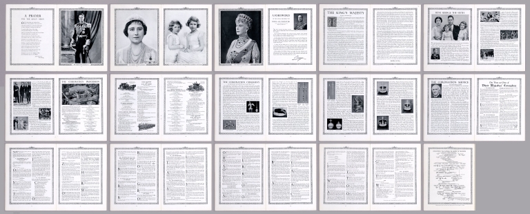
King George's Jubilee Trust
Full Title
(Covers to) The Coronation of their Majesties King George VI & Queen Elizabeth. Official Souvenir Programme. King George's Jubilee Trust.
List No
12482.001
Note
Coronation on May 12, 1937.
Author
[King George's Jubilee Trust, Gill, Leslie Macdonald]
Full Title
Coronation Procession of their Majesties King George VI & Queen Elizabeth.
List No
12482.002
Note
Coronation on May 12, 1937.
Author
King George's Jubilee Trust
Full Title
(Title Page) Coronation Procession of their Majesties King George VI & Queen Elizabeth, May 12, 1937.
List No
12482.003
Author
King George's Jubilee Trust
Full Title
(Composite Text) Coronation Procession of their Majesties King George VI & Queen Elizabeth.
List No
12482.004
Author
Andriveau-Goujon, E. (Eugène), 1832-1897
Full Title
(Title Page to) Atlas universel de géographie moderne. Publié par E. Andriveau-Goujon, Paris: Rue du Bac, 4.
List No
14008.003
Note
Title page includes table of contents for 25 maps in atlas. Text at bottom of sheet: Paris. - Typ. G. Chamerot. - 8658.
Author
Andriveau-Goujon, E. (Eugène), 1832-1897
Full Title
(1) Mappemonde en deux hémispheres. 1878. Publiée par E. Andriveau-Goujon, Rue du Bac, 4, Paris. Gravé par Ch. Dyonnet; ecrit par P. Rousset; Paris, Impie. de Louis Antoine, Rue des Noyers, 70.
List No
14008.004
Note
Hand-colored, engraved world map in two hemispheres: occidental and oriental (on double plate with decorative border). Includes text at bottom: Colonies Européennes : Angleterre, France, Espagne, Portugal, Hollande, Danemark. "No. 1" in upper right.
Author
Andriveau-Goujon, E. (Eugène), 1832-1897
Full Title
(2) Carte de l'Europe et du Bassin de la Méditerranée. Publiée par E. Andriveau-Goujon, 4, Rue du Bac. Paris, 1879. Paris, Impie. Alfred Chardon Jeune; gravée: la géographie par Smith; les escritures par P. Rousset; les eaux par Mm. Fontaine.
List No
14008.005
Note
Hand-colored, engraved map of Europe and the greater Mediterranean Region, showing political boundaries, roads and railroads (on double plate with decorative border). Includes legend, as well as 10 bar scales and a scale statement. Handwritten annotation in blue ink traces a route in southwestern Germany. "No. 2" in upper right.
Author
Andriveau-Goujon, E. (Eugène), 1832-1897
Full Title
(Composite to) Carte orographique hydrographique et routière de la France comprenant le Bassin du Rhin et la Région des Alpes occidentales réduite de la nouvelle carte de France de l'État-Major dressée au Dépôt de la Guerre. Publiée par E. Andriveau-Goujon, Rue du Bac, 4, Paris, 1881. Gravé sur Acier; le trait par Smith; la topographie par Gérin; les ecritures par P. Rousset; les eaux par Fontaine; Impie. Alfred Chardon Jne.
List No
14008.013
Note
Hand-colored, engraved fold-out map of France, showing political boundaries, roads and railroads (on double plate with decorative border, on two consecutive sheets: 8 and 9). Includes legend, as well as 3 bar scales and a scale statement. With inset: (Bouches de Bonifacio).
Author
Andriveau-Goujon, E. (Eugène), 1832-1897
Full Title
(13) Empire d’Allemagne et pays limitrophes. E. Andriveau-Goujon, éditeur, Rue du Bac, 4, Paris, 1880. Gravé chez L. Wuhrer, rue de l'Abbé de l'Epée 4; Imp. Monroco, Paris.
List No
14008.017
Note
Hand-colored, engraved map of Germany, showing showing political boundaries, roads, railroads and water routes (on double plate). Includes legend, as well as a bar scale and a scale statement. Features a table: Tableau des états de l'Empire d’Allemagne. "Atlas usuel, No. 15" and "Atlas universel, No. 30" in lower left.
Author
Andriveau-Goujon, E. (Eugène), 1832-1897
Full Title
(15) Empire Ottoman et Grèce. Publié par E. Andriveau-Goujon, Rue du Bac, 4, Paris, 1879. Paris, Imp. Alfred Chardon Jne.; gravé: le trait par Smith; la topographie par Gérin; les ecritures par Rousset; les eaux par Mme. Fontaine.
List No
14008.019
Note
Hand-colored, engraved map of the Ottoman Empire and Greece, showing showing political boundaries, roads, railroads and water routes (on double plate with decorative border). Includes legend indicating ethnic divisions, as well 6 bar scales and a scale statement. Features a table: Explication de quelques dénominations géographiques. "No. 15" in upper right. "Atlas usuel, No. 21" and "Atlas universel, No. 54" in lower left.
Author
Andriveau-Goujon, E. (Eugène), 1832-1897
Full Title
(16) Carte physique & politique de l'Asie. Publiée par E. Andriveau-Goujon, 4, Rue du Bac, Paris, 1881. Gravée par Ch. Smith et Gérin; les eaux par Mme. Fontaine; Paris, Impie. Ch. Chardon, ainé, 10, r. de l'Abbaye; la lettre par Isid. Dalmont.
List No
14008.020
Note
Hand-colored, engraved map of Asia, showing showing political boundaries, roads, railroads and water routes (on double plate with decorative border). Includes legend, as well as 10 bar scales. "No. 16" in upper right. "Atlas usuel, No. 21" and "Atlas universel, No. 54" in lower left.
Author
Andriveau-Goujon, E. (Eugène), 1832-1897
Full Title
(18) Palestine ancienne & moderne d'aprés les sources les plus authentiques. Par E. Andriveau-Goujon. Paris, 1876. E. Andriveau-Goujon, éditeur. Rue du Bac, 4. Paris, imprimie. Ch. Chardon; gravé: le trait par Smith; les montagnes par Gérin; les ecritures par P. Rousset; les eaux par Mme. Fontaine.
List No
14008.022
Note
Hand-colored, engraved map of the Holy Land, showing political boundaries, roads and railroads (with decorative border). Includes legend, index, as well as 4 bar scales and a scale statement. Features translations into French. "No. 18" in upper right. "Atlas usuel, No. 23" and "Atlas universel, No. 36" in lower right. With 5 insets: (Egypt; Palestine; Arabie) -- (Golfe de Suez) -- (Niveau de la Méditerranée) -- ([Profile of mountains in vicinity of Jerusalem]) -- Jérusalem d'aprés le plan de G. Williams.
Author
Andriveau-Goujon, E. (Eugène), 1832-1897
Full Title
(19) Carte générale de l'Afrique d'après les derraeres découvertes. Publiée par E. Andriveau-Goujon, 4, Rue du Bac, Paris, 1881. Nouvelle edition. Gravée par Smith et Gérin; les ecritures par P. Rousset.
List No
14008.023
Note
Hand-colored, engraved map of Africa, showing showing political boundaries, roads and railroads (on double plate with decorative border). Includes legend indicating colonies (English, French, Spanish, Portuguese and of the Sultan of Zanzibar), as well as 5 bar scales. "No. 20" in upper right. With 8 insets: (Iles Canaries) -- (Madère) -- (Iles du Cap Vért) -- (Ile de l'Ascension) -- (Ile Ste. Hélène) -- (Ile Mayotte) -- (Iles Nossi-Be) -- (Iles Mascareignes).
Author
Andriveau-Goujon, E. (Eugène), 1832-1897
Full Title
(20) Algérie d'après les cartes de l'état-major et les documents du Ministère de la Guerre. E. Andriveau-Goujon, éditeur. Paris, Rue du Bac, 4, 1880. Paris, Impie. Alfred Chardon jeune; Gravée par Ms. Gérin; Dalmont, Smith et Fontaine.
List No
14008.024
Note
Hand-colored, engraved map of Algeria and greater North Africa, showing showing political boundaries, roads, railroads, water routes and military divisions (on double plate with decorative border). Includes legend, as well as 2 bar scales and a scale statement. "No. 21" in upper right. "Atlas usuel, No. 28" and "Atlas universel, No. 41" in lower right. With inset (indexed to show colonies): Carte d'Ensemble des rapports entre la France, l'Algérie, la Sénégambie et le Nord de l'Afrique.
Author
Andriveau-Goujon, E. (Eugène), 1832-1897
Full Title
(21) Carte de la Basse-Égypte et du Canal Maritime de Suez. Publiée par E. Andriveau-Goujon, éditeur. Rue du Bac, 21, Paris, 1880. Gravé sur pierre et chrom. par P. Méa, 14, r. des Fsés. St. Bernard; Imp. Lemercier et Cie. r. de Seine, 57, Paris.
List No
14008.025
Note
Hand-colored, engraved map of Egypt and greater North Africa, including the Suez Canal, showing showing political boundaries, roads, railroads and water routes (with decorative border). Includes legend, as well as 3 bar scales and a scale statement. "Inauguration du Canal, 17 Novembre 1869" in both upper left and right. With 3 insets: Plan d'Ismaïlia (scale 1:25,000) -- Plan de la Rade de Port Saïd et de l'embouchure du canal dans la Mediterranée (scale 1:60,000) -- Plan de la rade de Suez et de l'embouchure du canal dans la Mer Rouge (scale 1:60,000).
Author
Andriveau-Goujon, E. (Eugène), 1832-1897
Full Title
(22) Carte générale de l'Océanie. Publiée E. Andriveau-Goujon, 4, Rue du Bac, Paris, 1876. Impie. de Louis Antoine; gravé par Ch. Smith et Gérin; les eaux par Mme. Fontaine.
List No
14008.026
Note
Hand-colored, engraved map of Oceania, including the East Indies, Australia, New Zealand, and other others, showing the borders between the seas and oceans (on double plate with decorative border). Includes legend indicating European colonies (English, French, Dutch, Spanish and Portuguese). "No. 22" in upper right. With 3 insets: Iles Nouka-Hiva -- Iles Taïti -- Terres Australes.
Author
Andriveau-Goujon, E. (Eugène), 1832-1897
Full Title
(23) Amérique du Nord. Paris, 1877. E. Andriveau-Goujon, éditeur, Rue du Bac, 4. Gravé chez L. Wuhrer, R. Gay-Lussac, 52, Paris; Imp. Lemercier, Paris.
List No
14008.027
Note
Hand-colored, engraved map of North America, showing railroads, water routes with distances, ocean currents and glaciers (on double plate with decorative border). Includes legend indicating European colonies (English, French, Spanish, Danish, Swedish, Dutch, and American), as well as 4 bar scales and a scale statement. "Longitude ouest du Méridien de Paris". With inset: Iles Aléoutiennes.
Author
Andriveau-Goujon, E. (Eugène), 1832-1897
Full Title
(24) Carte générale des États-Unis et du Mexique comprenant l'Amérique centrale et les Antilles. E. Andriveau-Goujon, éditeur. Paris, Rue du Bac, 4. Nouvelle édition, 1876.
List No
14008.028
Note
Hand-colored, engraved map of the United States, Mexico, Central America and the Antilles, showing railroads and water routes (on double plate with decorative border). Includes legend indicating European colonies (French, English, Dutch, Danish, Spain and Swedish), as well as 4 bar scales. "No. 24" in upper right. With 4 insets: États de l'Amérique Centrale -- Entré de New-York -- Carte des rapports entre l'Europe & l'Amérique -- Petites Antilles et Nord de l'Amérique du Sud.
|

![Covers: [French composite sea atlas focusing on colonization in Southeast Asia].](https://www.davidrumsey.com/rumsey/Size2/RUMSEY~8~1/205/14392001.jpg)