|
Author
Cary, John, ca. 1754-1835
Full Title
A new map of Yorkshire : divided into its ridings and subdivided into its hundreds, exhibiting its roads, rivers, parks &c. By John Cary, Engraver 1808. London. : Published by J. Cary ..., June 1 1808. (to accompany) Cary's new English atlas : being a complete set of county maps, from actual surveys, corresponding in size with his general atlas ...
List No
13082.046
Note
1 map on 4 sheets, copperplate engraving hand-colored. Title from sheet 4. Shows boundaries, towns, rivers, roads, woods, parks and settlements. Prime meridian is Greenwich. Relief shown by hachures.
Author
Cary, John, ca. 1754-1835
Full Title
A new map of Yorkshire : divided into its ridings and subdivided into its hundreds, exhibiting its roads, rivers, parks &c. By John Cary, Engraver 1808. London. : Published by J. Cary ..., June 1 1808. (to accompany) Cary's new English atlas : being a complete set of county maps, from actual surveys, corresponding in size with his general atlas ...
List No
13082.047
Note
1 map on 4 sheets, copperplate engraving hand-colored. Title from sheet 4. Shows boundaries, towns, rivers, roads, woods, parks and settlements. Prime meridian is Greenwich. Relief shown by hachures.
Author
Cary, John, ca. 1754-1835
Full Title
(Composite Map) A new map of Yorkshire : divided into its ridings and subdivided into its hundreds, exhibiting its roads, rivers, parks &c. By John Cary, Engraver 1808. London. : Published by J. Cary ..., June 1 1808. (to accompany) Cary's new English atlas : being a complete set of county maps, from actual surveys, corresponding in size with his general atlas ...
List No
13082.048
Note
Composite map of sheets 41-44: A new map of Yorkshire, 1808.
Author
Cary, John, ca. 1754-1835
Full Title
A new map of the Principality of Wales : divided into counties. By John Cary, Engraver 1809. London. : Published by J. Cary ..., Feb. 24. 1809. (to accompany) Cary's new English atlas : being a complete set of county maps, from actual surveys, corresponding in size with his general atlas ...
List No
13082.049
Note
Copperplate engraving hand-colored. Shows administrative boundaries, cities, towns, rivers, roads, woods, parks and settlements. Prime meridian is Greenwich. Relief shown by hachures.
Author
Cary, John, ca. 1754-1835
Full Title
A new map of the Principality of Wales : divided into counties. By John Cary, Engraver 1809. London. : Published by J. Cary ..., Feb. 24. 1809. (to accompany) Cary's new English atlas : being a complete set of county maps, from actual surveys, corresponding in size with his general atlas ...
List No
13082.050
Note
Copperplate engraving hand-colored. Shows administrative boundaries, cities, towns, rivers, roads, woods, parks and settlements. Prime meridian is Greenwich. Relief shown by hachures.
Author
Cary, John, ca. 1754-1835
Full Title
(Composite Map) A new map of the Principality of Wales : divided into counties. By John Cary, Engraver 1809. London. : Published by J. Cary ..., Feb. 24. 1809. (to accompany) Cary's new English atlas : being a complete set of county maps, from actual surveys, corresponding in size with his general atlas ...
List No
13082.051
Note
Composite map of sheets 41-44: A new map of the Principality of Wales.
Author
Cary, John, ca. 1754-1835
Full Title
A two sheet map of the principality of Wales : divided into counties : London printed for C. Smith, no. 172 Strand January 6th. 1804. 2nd. edition corrected to 1808. (to accompany) Cary's new English atlas : being a complete set of county maps, from actual surveys, corresponding in size with his general atlas ...
List No
13082.052
Note
Copperplate engraving hand-colored. Shows administrative boundaries, cities, towns, rivers, roads, woods, parks and settlements. Prime meridian is Greenwich. Relief shown by hachures. Includes explanation.
Author
Cary, John, ca. 1754-1835
Full Title
A two sheet map of the principality of Wales : divided into counties : London printed for C. Smith, no. 172 Strand January 6th. 1804. 2nd. edition corrected to 1808. (to accompany) Cary's new English atlas : being a complete set of county maps, from actual surveys, corresponding in size with his general atlas ...
List No
13082.053
Note
Copperplate engraving hand-colored. Shows administrative boundaries, cities, towns, rivers, roads, woods, parks and settlements. Prime meridian is Greenwich. Relief shown by hachures. Includes explanation.
Author
Cary, John, ca. 1754-1835
Full Title
(Composite Map) A two sheet map of the principality of Wales : divided into counties : London printed for C. Smith, no. 172 Strand January 6th. 1804. 2nd. edition corrected to 1808. (to accompany) Cary's new English atlas : being a complete set of county maps, from actual surveys, corresponding in size with his general atlas ...
List No
13082.054
Note
Composite map of sheets 46:1-2: A two sheet map of the principality of Wales.
Author
Cary, John, ca. 1754-1835
Full Title
(Composite Text) Cary English atlas : An Index ... Throughout England and Wales. (to accompany) Cary's new English atlas : being a complete set of county maps, from actual surveys, corresponding in size with his general atlas ...
List No
13082.055
Note
Composite text:Cary English atlas: An Index ... Throughout England and Wales.
Author
Minard, Charles Joseph, 1781-1870
Full Title
(Covers to) Des embouchures des rivieres navigables. Par M. Minard. Paris. Imprime par E.Thuunot e Co. rue Bacine, 26.
List No
13083.001
Author
Minard, Charles Joseph, 1781-1870
Full Title
(Composite Text to) Des embouchures des rivieres navigables. Par M. Minard. Paris. Imprime par E.Thuunot e Co. rue Bacine, 26.
List No
13083.00
Note
Composite text, Pages 2028. Continues Introduction. Text to Le Rhone. L'Adour. La Seine Rivers.
Author
Minard, Charles Joseph, 1781-1870
Full Title
Plan de la Seine maritime de Villequier an Havre. ... Autog. Regnier & Dourdet. (to accompany) Des embouchures des rivieres navigables. Par M. Minard. Paris. Imprime par E.Thuunot e Co. rue Bacine, 26.
List No
13083.007
Note
5 figures and profiles of Seine River on 1 folded sheet. Shows the navigation course and canals. Relief shown by hachures. Depth shown by soundings.
Author
Minard, Charles Joseph, 1781-1870
Full Title
1834 et 1863 (Mai) Sondes de chenal de la Baie de Seine sdou les cartes de la Marine 1834 No. 949 et 1863 No. 2088 ... Autog. Regnier & Dourdet. (to accompany) Des embouchures des rivieres navigables. Par M. Minard. Paris. Imprime par E.Thuunot e Co. rue Bacine, 26.
List No
13083.008
Note
6 figures on 1 folded sheet. Shows the channel probes of the Seine Bay in various times. Relief shown by hachures. Depth shown by soundings.
Author
Minard, Charles Joseph, 1781-1870
Full Title
Partie de la Baie de Seine entre Tancarville et St. Sauveur d'apres la Carte de la Marine de Mai 1863 ... Autog. Regnier & Dourdet. (to accompany) Des embouchures des rivieres navigables. Par M. Minard. Paris. Imprime par E.Thuunot e Co. rue Bacine, 26.
List No
13083.009
Note
Folded Nautical chart of the part of the Seine Bay between Tancarville and St. Sauveur. Depth shown by soundings. Includes notes.
Author
France. Ministere de l'agriculture
Full Title
(Covers to) Ministere de l'Agriculture. Album de statistique agricole : resultats generaux de l'enqute de annale de 1882. Nancy : Imprimerie Administrative Berger-Levrault, M DCCCLXXXVII (1887).
List No
13085.001
Author
France. Ministere de l'agriculture
Full Title
(Half Title Page to) Ministere de l'Agriculture. Album de statistique agricole : resultats generaux de l'enqute de annale de 1882. Nancy : Imprimerie Administrative Berger-Levrault, M DCCCLXXXVII (1887).
List No
13085.002
Author
France. Ministere de l'agriculture
Full Title
(Text Page to) Ministere de l'Agriculture. Album de statistique agricole : resultats generaux de l'enqute de annale de 1882. Nancy : Imprimerie Administrative Berger-Levrault, M DCCCLXXXVII (1887).
List No
13085.004
Author
France. Ministere de l'agriculture
Full Title
(Text Page to) Ministere de l'Agriculture. Album de statistique agricole : resultats generaux de l'enqute de annale de 1882. Nancy : Imprimerie Administrative Berger-Levrault, M DCCCLXXXVII (1887).
List No
13085.005
Author
France. Ministere de l'agriculture
Full Title
(Text Page to) Ministere de l'Agriculture. Album de statistique agricole : resultats generaux de l'enqute de annale de 1882. Nancy : Imprimerie Administrative Berger-Levrault, M DCCCLXXXVII (1887).
List No
13085.006
Author
France. Ministere de l'agriculture
Full Title
Table des planches. Ministere de l'Agriculture. Album de statistique agricole : resultats generaux de l'enqute de annale de 1882. Nancy : Imprimerie Administrative Berger-Levrault, M DCCCLXXXVII (1887).
List No
13085.007
Author
France. Ministere de l'agriculture
Full Title
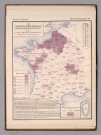
III. Surface ensemencee en cereales par 100 habitants de la population total en 1882. E' carts des moyennes departmentales par rapport a la moyenne generale. Imp. Clerc et Catineau - Paris. (in upper margin) Ministere de l'Agriculture. Album de statistique agricole,1887.
List No
13085.010
Note
Map showing of grain planting areas per 100 inhabitants of the total population in 1882, and the departmental average in relation to the general average. Insets: Algerie; Corse. Includes legend and color coded key.
Author
France. Ministere de l'agriculture
Full Title
IV. Surface ensemencee en froment par 100 hectares du territoire total en 1882. E' carts des moyennes departmentales par rapport a la moyenne generale. Imp. Clerc et Catineau - Paris. (in upper margin) Ministere de l'Agriculture. Album de statistique agricole,1887.
List No
13085.011
Note
Map showing of wheat planting areas per 100 hactares of the total territory in 1882, and the departmental average in relation to the general average. Insets: Algerie; Corse. Includes legend and color coded key.
Author
France. Ministere de l'agriculture
Full Title
V. Comparaison des superficies ensemencee en froment en 1882 et 1862. E' carts des moyennes departmentales par rapport a la moyenne generale. Imp. Clerc et Catineau - Paris. (in upper margin) Ministere de l'Agriculture. Album de statistique agricole,1887. 2
List No
13085.012
Note
Map showing comparison of wheat planting areas in 1882 and 1862, and the departmental average in relation to the general average. Insets: Algerie; Corse. Includes legend and color coded key.
Author
France. Ministere de l'agriculture
Full Title
VI. Production du froment par 100 hectares du territoire total en 1882. E' carts des moyennes departmentales par rapport a la moyenne generale. Imp. Clerc et Catineau - Paris. (in upper margin) Ministere de l'Agriculture. Album de statistique agricole,1887. 2
List No
13085.013
Note
Map showing comparison of the wheat production areas in 1882, and the departmental average in relation to the general average. Insets: Algerie; Corse. Includes legend and color coded key.
Author
France. Ministere de l'agriculture
Full Title
VII. Production du froment par hectare surface ensemencee, En 1882. E' carts des moyennes departmentales par rapport a la moyenne generale. Imp. Clerc et Catineau - Paris. (in upper margin) Ministere de l'Agriculture. Album de statistique agricole,1887.
List No
13085.014
Note
Map showing the wheat production per acres planted area in 1882, and the departmental average in relation to the general average. Insets: Algerie; Corse. Includes legend and color coded key.
Author
France. Ministere de l'agriculture
Full Title
VIII. Production du froment par habitant de la population total, En 1882. E' carts des moyennes departmentales par rapport a la moyenne generale. Imp. Clerc et Catineau - Paris. (in upper margin) Ministere de l'Agriculture. Album de statistique agricole,1887.
List No
13085.015
Note
Map showing the Wheat production per capita of total population in 1882, and the departmental average in relation to the general average. Insets: Algerie; Corse. Includes legend and color coded key.
Author
France. Ministere de l'agriculture
Full Title
IX. Production du froment par cultivateur (exploitant et salaries), En 1882. E' carts des moyennes departmentales par rapport a la moyenne generale. Imp. Clerc et Catineau - Paris. (in upper margin) Ministere de l'Agriculture. Album de statistique agricole,1887.
List No
13085.016
Note
Map showing the Wheat Production by farmer and employees, In 1882, and the departmental average in relation to the general average. Insets: Algerie; Corse. Includes legend and color coded key.
Author
France. Ministere de l'agriculture
Full Title
X. Comparaison de la production du froment, En 1882 et 1862. E' carts des moyennes departmentales par rapport a la moyenne generale. Imp. Clerc et Catineau - Paris. (in upper margin) Ministere de l'Agriculture. Album de statistique agricole,1887.
List No
13085.017
Note
Map showing the comparison of the production of wheat, In 1882 and 1862, and the departmental average in relation to the general average. Insets: Algerie; Corse. Includes legend and color coded key.
Author
France. Ministere de l'agriculture
Full Title
XI. Surface des cultures fourrageres par 100 hectares du territoire total, en 1882. E' carts des moyennes departmentales par rapport a la moyenne generale. Imp. Clerc et Catineau - Paris. (in upper margin) Ministere de l'Agriculture. Album de statistique agricole,1887.
List No
13085.018
Note
Map showing the areas of forage crops per 100 hactares of the total territory in 1882, and the departmental average in relation to the general average. Insets: Algerie; Corse. Includes legend and color coded key.
Author
France. Ministere de l'agriculture
Full Title
XII. Surface des cultures industrielles par 100 hectares du territoire total, en 1882. E' carts des moyennes departmentales par rapport a la moyenne generale. Imp. Clerc et Catineau - Paris. (in upper margin) Ministere de l'Agriculture. Album de statistique agricole,1887.
List No
13085.019
Note
Map showing the areas of industrial per 100 hactares of the total territory in 1882, and the departmental average in relation to the general average. Insets: Algerie; Corse. Includes legend and color coded key.
Author
France. Ministere de l'agriculture
Full Title
XIII. Nombre de chevaux par 100 hectares du territoire total, en 1882. E' carts des moyennes departmentales par rapport a la moyenne generale. Imp. Clerc et Catineau - Paris. (in upper margin) Ministere de l'Agriculture. Album de statistique agricole,1887.
List No
13085.020
Note
Map showing the number of horses per 100 hectares of total territory, 1882, and the departmental average in relation to the general average. Insets: Algerie; Corse. Includes legend and color coded key.
Author
France. Ministere de l'agriculture
Full Title
XIV. Poids des animaux de l'espece bovine par hectare du territoire total, en 1882. E' carts des moyennes departmentales par rapport a la moyenne generale. Imp. Clerc et Catineau - Paris. (in upper margin) Ministere de l'Agriculture. Album de statistique agricole,1887.
List No
13085.021
Note
Map showing the weight of animals of the bovine species per hectare of the total territory, 1882, and the departmental average in relation to the general average. Insets: Algerie; Corse. Includes legend and color coded key.
Author
France. Ministere de l'agriculture
Full Title
XV. Poids des animaux de l'espece ovine par hectare du territoire total, en 1882. E' carts des moyennes departmentales par rapport a la moyenne generale. Imp. Clerc et Catineau - Paris. (in upper margin) Ministere de l'Agriculture. Album de statistique agricole,1887.
List No
13085.022
Note
Map showing the weight of animals of the sheep species per hectare of the total territory, 1882, and the departmental average in relation to the general average. Insets: Algerie; Corse. Includes legend and color coded key.
Author
France. Ministere de l'agriculture
Full Title
XVI. Poids des animaux de l'espece porcine par hectare du territoire total, en 1882. E' carts des moyennes departmentales par rapport a la moyenne generale. Imp. Clerc et Catineau - Paris. (in upper margin) Ministere de l'Agriculture. Album de statistique agricole,1887.
List No
13085.023
Note
Map showing the weight of animals of the pig species per hectare of the total territory, 1882, and the departmental average in relation to the general average. Insets: Algerie; Corse. Includes legend and color coded key.
Author
France. Ministere de l'agriculture
Full Title
XVII. Population rurale par rapport a la population totale par departement, en 1882. E' carts des moyennes departmentales par rapport a la moyenne generale. Imp. Clerc et Catineau - Paris. (in upper margin) Ministere de l'Agriculture. Album de statistique agricole,1887.
List No
13085.024
Note
Map showing the rural population in relation to total population by department, 1882, and the departmental average in relation to the general average. Insets: Algerie; Corse. Includes legend and color coded key.
Author
France. Ministere de l'agriculture
Full Title
XVIII. Pourcentage des diverses categories de travailleurs agricoles par departement , en 1882. E' carts des moyennes departmentales par rapport a la moyenne generale. Imp. Clerc et Catineau - Paris. (in upper margin) Ministere de l'Agriculture. Album de statistique agricole,1887.
List No
13085.025
Note
Map showing the percentage of various categories of agricultural workers by department, 1882, and the departmental average in relation to the general average. Insets: Algerie; Corse. Includes legend, statistical table and color coded key.
Author
France. Ministere de l'agriculture
Full Title
XIX. Pourcentage du nombre d'exploitations rurales par categories d'etendue et par departement, en 1882. E' carts des moyennes departmentales par rapport a la moyenne generale. Imp. Clerc et Catineau - Paris. (in upper margin) Ministere de l'Agriculture. Album de statistique agricole,1887.
List No
13085.026
Note
Map showing the percentage of rural farms by extent and department, 1882, and the departmental average in relation to the general average. Insets: Algerie; Corse; France; Seine. Includes legend, statistical table and color coded key.
Author
France. Ministere de l'agriculture
Full Title
XX. Pourcentage du modes d'exploitations par departement, en 1882. (Faire-valoir direct - Metayage - Fermage), E' carts des moyennes departmentales par rapport a la moyenne generale. Imp. Clerc et Catineau - Paris. (in upper margin) Ministere de l'Agriculture. Album de statistique agricole,1887.
List No
13085.027
Note
Map showing the percentage of farming methods by department, in 1882, and the departmental average in relation to the general average. Insets: Algerie; Corse; France; Seine. Includes legend, statistical table and color coded key.
Author
France. Ministere de l'interieur. Service de la carte de France et de la statistique graphique
Full Title
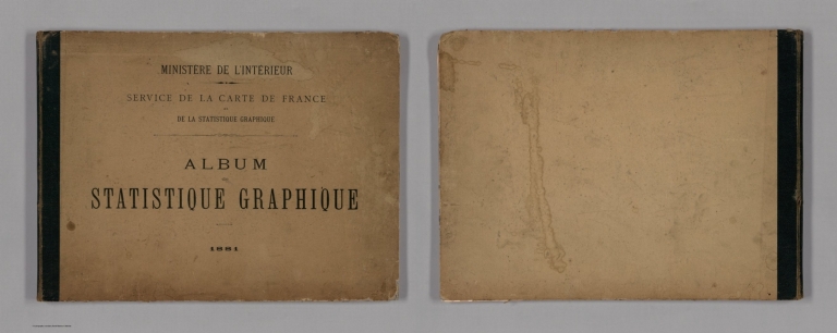
(Covers to) Ministere de l'interieur : Service de la carte de France et de la statistique graphique. : Album de statistique graphique. 1881.
List No
13086.001
Note
Statistical atlas of France. Contains 16 maps and 19 diagrams, relating to the enumeration of the population, local roads, transportation, French emigration, hospices and charitable offices, children in attendance, and elections. Covered in quarter bound with linen on tan cardboard boards.
Author
France. Ministere de l'interieur. Service de la carte de France et de la statistique graphique
Full Title
(Index Page to) Ministere de l'interieur : Service de la carte de France et de la statistique graphique. : Album de statistique graphique. 1881.
List No
13086.003
Note
Statistical atlas of France. Contains 16 maps and 19 diagrams, relating to the enumeration of the population, local roads, transportation, French emigration, hospices and charitable offices, children in attendance, and elections. Covered in quarter bound with linen on tan cardboard boards.
Author
France. Ministere de l'interieur. Service de la carte de France et de la statistique graphique
Full Title
Superficie moyene des communes. Dressee d'apres les renseignements fournis par le 1er. Bureau de la Division de l'Administration generale et departmentale. Grave par Erhard, Paris. Imp. Erhard. (in upper margin) Ministere de l'interieur : Administration departemmentale et communale. Statistique graphique - 1881. (inset) Corse.
List No
13086.007
Note
Color map of France, Shows administrative divisions. With color coded statistical table.
Author
France. Ministere de l'interieur. Service de la carte de France et de la statistique graphique
Full Title
Population moyenne des communes. Dressee d'apres les renseignements fournis par le 1er. Bureau de la Division de l'Administration generale et departmentale. Grave par Erhard, Paris. Imp. Erhard. (in upper margin) Ministere de l'interieur : Administration departemmentale et communale. Statistique graphique - 1881. (inset) Corse.
List No
13086.008
Note
Color map of France, Shows administrative divisions. With color coded statistical table.
Author
France. Ministere de l'interieur. Service de la carte de France et de la statistique graphique
Full Title
(Index page to) Centime communal. Classement des communes suivant la valeur du centime en 1880. (to accompany) Album de statistique graphique. 1881.
List No
13086.009
Note
Statistical table to the graphic chart No. 1.
Author
France. Ministere de l'interieur. Service de la carte de France et de la statistique graphique
Full Title
Centime communal. Classement des communes suivant la valeur du centime en 1880. Etabli d'apres les renseignements fournis par le 1er. Bureau de la Division de l'Administration communale et hospitaliere. Imp. Erhard. (in upper margin) Ministere de l'interieur : Administration departemmentale et communale. Statistique graphique - 1881.
List No
13086.010
Note
Chart of the departments provided by the 1st. Office of the Division of Municipal and Hospital Administration. Includes legend and table in lower panel.
Author
France. Ministere de l'interieur. Service de la carte de France et de la statistique graphique
Full Title
(Index Page to) Impositions communales. Classement des communes suivant le nombre de centimes qu'elle supportaient en 1880. (in upper margin) Statistique graphique - 1881. (to accompany) Album de statistique graphique.
List No
13086.011
Note
Statistical table to the graphic chart No. 2.
Author
France. Ministere de l'interieur. Service de la carte de France et de la statistique graphique
Full Title
Impositions communales. Classement des communes suivant le nombre de centimes qu'elle supportaient en 1880. Etabli d'apres les renseignements fournis par le 1er. Bureau de la Division de l'Administration communale et hospitaliere. Imp. Erhard. (in upper margin) Ministere de l'interieur : Administration departemmentale et communale. Statistique graphique - 1881.
List No
13086.012
Note
Chart of the municipal tax by departments provided by the 1st. Office of the Division of Municipal and Hospital Administration. Includes legend and table in lower panel.
Author
France. Ministere de l'interieur. Service de la carte de France et de la statistique graphique
Full Title
Imposition communales 1877. Dressee d'apres les renseignements fournis par le 1er. Bureau de la Division de l'Administration communale et hospitaliere. Grave par Erhard, Paris. Imp. Erhard. (in upper margin) Ministere de l'interieur : Administration departemmentale et communale. Statistique graphique - 1881. (inset) Corse.
List No
13086.013
Note
Color map of France, Shows administrative divisions. With color coded statistical table.
Author
France. Ministere de l'interieur. Service de la carte de France et de la statistique graphique
Full Title
Revenus communaux 1877. Dressee d'apres les renseignements fournis par le 1er. Bureau de la Division de l'Administration communale et hospitaliere. Grave par Erhard, Paris. Imp. Erhard. (in upper margin) Ministere de l'interieur : Administration departemmentale et communale. Statistique graphique - 1881. (inset) Corse.
List No
13086.014
Note
Color map of France, Shows administrative divisions. With color coded statistical table.
Author
France. Ministere de l'interieur. Service de la carte de France et de la statistique graphique
Full Title
Emprunt et dettes des communes 1877. Dressee d'apres les renseignements fournis par le 1er. Bureau de la Division de l'Administration communale et hospitaliere. Grave par Erhard, Paris. Imp. Erhard. (in upper margin) Ministere de l'interieur : Administration departemmentale et communale. Statistique graphique - 1881. (inset) Corse.
List No
13086.015
Note
Color map of France, Shows administrative divisions. With color coded statistical table.
|