Who What Where WhenWHATShow MoreWHO
WHEN
|
Full Title
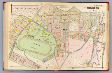
Part of Yonkers. Plate 20. (A.H. Mueller, lith., Philada., 1907)
List No
0650.021
Note
Hand colored map. Maps in this atlas show buildings by construction material (stone, brick, frame, iron) with name or function, landowners, fire hydrants, water and sewer pipes, railroads, paved, unpaved and unopened streets, aqueducts and city and ward boundaries. Includes Empire City Park, Shearwood Hill, Sherwood Park, Belmont and West Mount Vernon Station.
Full Title
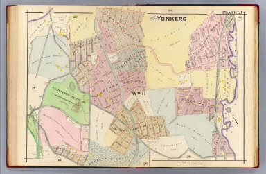
Part of Yonkers. Plate 21. (A.H. Mueller, lith., Philada., 1907)
List No
0650.022
Note
Hand colored map. Maps in this atlas show buildings by construction material (stone, brick, frame, iron) with name or function, landowners, fire hydrants, water and sewer pipes, railroads, paved, unpaved and unopened streets, aqueducts and city and ward boundaries. Includes Saint Josephs Seminary, Glen Washington, Glen Washington Park, Gunther Estate, Sunnyside Park and Lincoln Heights.
Full Title
Part of Yonkers. Plate 22. (A.H. Mueller, lith., Philada., 1907)
List No
0650.023
Note
Hand colored map. Maps in this atlas show buildings by construction material (stone, brick, frame, iron) with name or function, landowners, fire hydrants, water and sewer pipes, railroads, paved, unpaved and unopened streets, aqueducts and city and ward boundaries. Includes Bryn Mawr Park Station, Armour Villa Park, Bronxville Park, Glen Washington, Bronx Manor and South Bronxville.
Full Title
Part of Yonkers. Plate 23. (A.H. Mueller, lith., Philada., 1907)
List No
0650.024
Note
Hand colored map. Maps in this atlas show buildings by construction material (stone, brick, frame, iron) with name or function, landowners, fire hydrants, water and sewer pipes, railroads, paved, unpaved and unopened streets, aqueducts and city and ward boundaries. Includes Grassy Sprain Reservoir, Mohegan Park, Crestwood, Yonkers Park, Yonkers Park Station and Tuckahoe Station.
Full Title
Part of Yonkers. Plate 24. (A.H. Mueller, lith., Philada., 1907)
List No
0650.025
Note
Hand colored map. Maps in this atlas show buildings by construction material (stone, brick, frame, iron) with name or function, landowners, fire hydrants, water and sewer pipes, railroads, paved, unpaved and unopened streets, aqueducts and city and ward boundaries. Includes Monrovia Park, Cegil Park and Saint Eleanora's Home.
Full Title
N.W. section borough of the Bronx. Plate 25. (A.H. Mueller, lith., Philada., 1907)
List No
0650.026
Note
Hand colored map. Maps in this atlas show buildings by construction material (stone, brick, frame, iron) with name or function, landowners, fire hydrants, water and sewer pipes, railroads, paved, unpaved and unopened streets, aqueducts and city and ward boundaries. Covers area north of West 246th Street and west of Broadway, including Academy of Mount Saint Vincent, Colored Orphan Asylum, Monastery of the Visitation, Riverdale Presbyterian Church and Mount Vincent Station.
Author
Nell, Louis
Full Title
(Covers to) Nell's Topographical Map Of The State Of Colorado. E.Besly & Co. Publishers, Denver. 1889. Copyright by Louis Nell, Washington D.C. 1887. Photo-Lith., Century Lith. Co. Phila. Pa.
List No
0664.001
Note
Full color by county. Folded into textured dark green cloth covers 17x10.5 with "Nell's Map of Colorado, E. Besly & Co., Denver." stamped in gilt.
Author
Nell, Louis
Full Title
Nell's Topographical Map Of The State Of Colorado. E.Besly & Co. Publishers, Denver. 1889. Copyright by Louis Nell, Washington D.C. 1887. Photo-Lith., Century Lith. Co. Phila. Pa.
List No
0664.002
Note
Full color by county. Folded into textured dark green cloth covers 17x10.5 with "Nell's Map of Colorado, E. Besly & Co., Denver." stamped in gilt. Relief shown by hachures and spot heights.
Author
Nell, Louis
Full Title
(Covers to) Nell's Topographical Map Of The State Of Colorado. The Kendrick Book & Stationery Co. Denver, 1905. C.A. Kendrick, Pres. H.E. Bellamy, Vice Pres. Copyright by Louis Nell, Denver, Colo. 1903. The Friedenwald Co. Photo-Lith. Balto.
List No
0665.001
Note
Late edition, printed color, 1" = 10 miles. This appears to be a reengraving of the earlier hand colored Nell Map of Colorado, perhaps to lessen the hachures and clarify the map. Timber Reserves are shown. With 12 page index, maroon cloth covers 18.5x12 stamped in gilt "Nell's Map of Colorado."
Author
Nell, Louis
Full Title
(Index to) Nell's Topographical Map Of The State Of Colorado. The Kendrick Book & Stationery Co. Denver, 1905. C.A. Kendrick, Pres. H.E. Bellamy, Vice Pres. Copyright by Louis Nell, Denver, Colo. 1903. The Friedenwald Co. Photo-Lith. Balto.
List No
0665.002
Note
Late edition, printed color, 1" = 10 miles. This appears to be a reengraving of the earlier hand colored Nell Map of Colorado, perhaps to lessen the hachures and clarify the map. Timber Reserves are shown. With 12 page index, maroon cloth covers 18.5x12 stamped in gilt "Nell's Map of Colorado."
Author
Nell, Louis
Full Title
Nell's Topographical Map Of The State Of Colorado. The Kendrick Book & Stationery Co. Denver, 1905. C.A. Kendrick, Pres. H.E. Bellamy, Vice Pres. Copyright by Louis Nell, Denver, Colo. 1903. The Friedenwald Co. Photo-Lith. Balto.
List No
0665.003
Note
Late edition, printed color, 1" = 10 miles. This appears to be a reengraving of the earlier hand colored Nell Map of Colorado, perhaps to lessen the hachures and clarify the map. Timber Reserves are shown. With 12 page index, maroon cloth covers 18.5x12 stamped in gilt "Nell's Map of Colorado." Relief shown by hachures and spot height.
Author
Nichols, Beach
Full Title
(Covers to) Atlas Of Montgomery And Fulton Counties, New York. From actual Surveys by and under the direction of B. Nichols. Assisted by H.B. Stranahan, W.A. Sherman, H. Loomer, P.A. Cunningham And S.W. Fosdick. Published By J. Jay Stranahan & Beach Nichols, 95 Maiden Lane, New York. 1868. Assistants, W.W. Richie, E.J. Sherwood. Assistants, T. Guernsey, N. Vroman. Entered ... Stranahan & Nichols in the year 1868 ... New York.
List No
0668.001
Note
Bound in light green cloth covered boards with label stamped with gold title "Atlas Of Montgomery And Fulton Counties, N.Y. Stranahan & Nichols."
Author
Nichols, Beach
Full Title
(Title Page) Atlas Of Montgomery And Fulton Counties, New York. From actual Surveys by and under the direction of B. Nichols. Assisted by H.B. Stranahan, W.A. Sherman, H. Loomer, P.A. Cunningham And S.W. Fosdick. Published By J. Jay Stranahan & Beach Nichols, 95 Maiden Lane, New York. 1868. Assistants, W.W. Richie, E.J. Sherwood. Assistants, T. Guernsey, N. Vroman. Entered ... Stranahan & Nichols in the year 1868 ... New York.
List No
0668.002
Author
Nichols, Beach
Full Title
(Table of Contents to) Atlas Of Montgomery And Fulton Counties, New York. From actual Surveys by and under the direction of B. Nichols. Assisted by H.B. Stranahan, W.A. Sherman, H. Loomer, P.A. Cunningham And S.W. Fosdick. Published By J. Jay Stranahan & Beach Nichols, 95 Maiden Lane, New York. 1868. Assistants, W.W. Richie, E.J. Sherwood. Assistants, T. Guernsey, N. Vroman. Entered ... Stranahan & Nichols in the year 1868 ... New York.
List No
0668.003
Author
Nichols, Beach
Full Title
(Text Page) Table of Air-Line Distances.
List No
0668.004
Author
Nichols, Beach
Full Title
New York. (insets) Oswego, Buffalo, Rochester, Syracuse, Albany, Troy, and Vicinity of New York.
List No
0668.005
Author
Nichols, Beach
Full Title
Outline Map of Montgomery Co. New York.
List No
0668.033
Author
Nichols, Beach
Full Title
The Village of Amsterdam.
List No
0668.006
Note
Foldout. Includes Business Directory.
Author
Nichols, Beach
Full Title
Amsterdam, Montgomery Co. (inset) Rock City. Hagamans Mills.
List No
0668.007
Note
Includes Business Directory.
Author
Nichols, Beach
Full Title
Florida, Montgomery Co. (inset) Fort Hunter.
List No
0668.008
Author
Nichols, Beach
Full Title
Tribes Hill. Port Jackson. Minaville.
List No
0668.009
Author
Nichols, Beach
Full Title
Glen, Montgomery Co. (inset) Auriesville. Glen.
List No
0668.010
Note
Includes Business Directory.
Author
Nichols, Beach
Full Title
Fonda. Fultonville
List No
0668.011
Note
Includes Business Directory.
Author
Nichols, Beach
Full Title
Charleston, Montgomery Co. (insets) Burtonville. Charleston Four Cor's.
List No
0668.012
Note
Includes Business Directory.
Author
Nichols, Beach
Full Title
St. Johnsville, Montgomery Co. N.Y. Mohawk, Montgomery Co. N.Y.
List No
0668.013
Author
Nichols, Beach
Full Title
Root, Montgomery Co. (insets) Spakers Basin. Browns Hollow. Yatesville. Rural Grove. Currytown.
List No
0668.014
Note
Includes Business Directory.
Author
Nichols, Beach
Full Title
Palatine, Montgomery County, New York. (insets) Palatine Church. Palatine Bridge.
List No
0668.015
Author
Nichols, Beach
Full Title
Canajoharie. Nelliston.
List No
0668.016
Note
Includes Business Directory.
Author
Nichols, Beach
Full Title
Canajoharie, Montgomery Co., N.Y. (insets) Sprout Brook. Marshville. Buel. Vandeusenville. Ames.
List No
0668.017
Author
Nichols, Beach
Full Title
Fort Plain.
List No
0668.018
Note
Includes Business Directories.
Author
Nichols, Beach
Full Title
Minden, Montgomery Co. (insets) Minden or Fords Bush. Mindenville. Freys Bush.
List No
0668.019
Author
Nichols, Beach
Full Title
Plan of Saint Johnsville.
List No
0668.020
Note
Includes Business Directory.
Author
Nichols, Beach
Full Title
Outline Map of Fulton Co. New York.
List No
0668.021
Author
Nichols, Beach
Full Title
City of Johnstown.
List No
0668.022
Note
Foldout.
Author
Nichols, Beach
Full Title
Gloversville, Fulton Co. N.Y.
List No
0668.023
Note
Includes Business Directory.
Author
Nichols, Beach
Full Title
Johnstown, Fulton Co.
List No
0668.024
Author
Nichols, Beach
Full Title
Mayfield, Fulton Co. Perth, Fulton Co. (insets) Kingsboro. Northampton. Vails Mills. Sammonsville. West Galway.
List No
0668.025
Note
Foldout.
Author
Nichols, Beach
Full Title
Northampton, Fulton Co. N.Y. (insets) Northville. Osborne's Bridge.
List No
0668.026
Note
Includes Business Directory.
Author
Nichols, Beach
Full Title
Broad Albin, Fulton County, N.Y. (inset) Broad Albin.
List No
0668.027
Author
Nichols, Beach
Full Title
Bleecker, Fulton Co.
List No
0668.028
Author
Nichols, Beach
Full Title
Caroga, Fulton Co. (insets) Newkirks Mills. Wheelerville.
List No
0668.029
Author
Nichols, Beach
Full Title
Stratford, Fulton Co. (inset) Stratford P.O.
List No
0668.030
Note
Includes Business Directory.
Author
Nichols, Beach
Full Title
Ephratah, Fulton Co. (insets) Lassellville. Ephratah. Rockwood.
List No
0668.031
Note
Includes Business Directory.
Author
Nichols, Beach
Full Title
Oppenheim, Fulton Co. (inset) Oppenheim.
List No
0668.032
Author
Nichols, Beach
Full Title
(Covers to) Atlas Of Schuyler County, New York. From actual Surveys by and under the direction of Beach Nichols, Published by Pomeroy, Whitman & Co. 31 So. Sixth St. Philadelphia, 1874. Entered ... 1874 by A. Pomeroy & Co. ... Washington. Engd. by Worley & Bracher, 31 So. Sixth St. Philada. Printed by F. Bourquin, 31 So. Sixth St. Philada.
List No
0669.001
Note
Bound in quarter leather dark brown cloth covered boards with a decoratively embossed title reading "Atlas Of Schuyler Co. New York. A. Pomeroy & Co." in gilt.
Author
Nichols, Beach
Full Title
(Title Page) Atlas Of Schuyler County, New York. From actual Surveys by and under the direction of Beach Nichols, Published by Pomeroy, Whitman & Co. 31 So. Sixth St. Philadelphia, 1874. Entered ... 1874 by A. Pomeroy & Co. ... Washington. Engd. by Worley & Bracher, 31 So. Sixth St. Philada. Printed by F. Bourquin, 31 So. Sixth St. Philada.
List No
0669.002
Author
Nichols, Beach
Full Title
(Table of Contents) Index.
List No
0669.003
Author
Nichols, Beach
Full Title
(Text Page) Table of Distances. Population. Post Offices.
List No
0669.004
Author
Nichols, Beach
Full Title
Map of the United States and Territories together with Canada &c. (inset) Island of Newfoundland.
List No
0669.005
Author
Nichols, Beach
Full Title
Plan of the State of New York, Drawn and Engraved especially for this Atlas.
List No
0669.006
|