|
Author
Morse, Jedidiah
Full Title
A Map of Vermont. I. Mutlow Sc. Published Octr. 2d, 1794, by I. Stockdale, PIccadilly.
List No
0632.006
Note
Without color. Counties noted.
Author
Morse, Jedidiah
Full Title
A Map of New Hampshire. Published July 17, 1794 by I. Stockdale, Piccadilly.
List No
0632.007
Note
Without color.
Author
Morse, Jedidiah
Full Title
A Map of Massachusetts from the best Authorities. I. Mutlow Sc. 6 James St. Covt. Gardn. Published July 8, 1794 by I. Stockdale, Piccadilly.
List No
0632.008
Note
Without color.
Author
Morse, Jedidiah
Full Title
A Map of Rhode Island. I. Mutlow Sculp. 6 James St. Published July 15, 1794 by I. Stockdale, Piccadilly.
List No
0632.009
Note
Without color.
Author
Morse, Jedidiah
Full Title
A Map of Connecticut. J. Roper, sc. Publish'd Augt. 10th 1794, by J. Stockdale, Piccadilly.
List No
0632.010
Note
Without color.
Author
Morse, Jedidiah
Full Title
A Map of the State of New York. J. Roper, sc. Published Augt. 20th 1794 by J. Stockdale, Piccadilly.
List No
0632.011
Note
Without color.
Author
Morse, Jedidiah
Full Title
A Map of New Jersey from the best Authorities. Published Sepr. 8th 1794 by J. Stockdale, Piccadilly.
List No
0632.012
Note
Without color.
Author
Morse, Jedidiah
Full Title
A Map of Pensylvania from the best Authorities. W. Harrison Junr. sc. Published 15th July 1794 by J. Stockdale, Piccadilly.
List No
0632.013
Note
Without color.
Author
Morse, Jedidiah
Full Title
A Map of the States of Virginia, North Carolina, South Carolina, and Georgia; Comprehending the Spanish Provinces of East and West Florida: Exhibiting the Boundaries as fixed by the late Treaty of Peace between the United States and the Spanish Dominions. Compiled from late Surveys & Observations by Joseph Purcell. W. Harrison Senr. & Junr. sc. Engraved for Morse's Geography. Publish'd by John Stockdale Jany. 25th 1792.
List No
0632.014
Note
Map shows the boundaries between the United States and the Spanish Dominions, the individual states, and the territories claimed by the Indian nations. Map without color.
Author
Morse, Jedidiah
Full Title
Plan of the City of Washington. Published by J. Stockdale, PIccadilly 16th Septr. 1794.
List No
0632.015
Note
Map without color.
Author
Morse, Jedidiah
Full Title
Map of Virginia, Maryland and Delaware. I. Mulow Sc. 6 James St. Covt. Gardn. Published July 16, 1794 by I. Stockdale, PIccadilly.
List No
0632.016
Note
Large foldout uncolored map showing roads, cities, and mountians in the area.
Author
Morse, Jedidiah
Full Title
A Map of the Back Settlements. Published, July 30, 1794 by I. Stockdale, Piccadilly.
List No
0632.017
Note
Uncolored map spanning the region from the eastern edge of Pennsylvania to the Mississippi River.
Author
Morse, Jedidiah
Full Title
A Map of Kentucky, Drawn from Actual Observations. By John Filson. (with) A Plan of the Rapids, in the River Ohio. Published Novr. 23, 1793, by John Stockdale, Piccadilly.
List No
0632.018
Note
Large foldout map of Kentucky showing stations, forts, salt springs and licks, towns, dwelling houses, mills and "wigwams". The river passages are described and historical information is included , i.e. "a bloody battle fought here."
Author
Morse, Jedidiah
Full Title
A Map of North Carolina from the best Authorities. Harrison sc. Published July 24th 1794 by J. Stockdale Piccadilly.
List No
0632.019
Note
Without color or legend.
Author
Morse, Jedidiah
Full Title
A Map of the Tennessee Government. 1794. Published Sep. 20 1794 by I. Stockdale, Piccadilly.
List No
0632.020
Note
An uncolored map showing the Cumberland, Tennessee, Ohio, and the adjacent Mississippi rivers.
Author
Morse, Jedidiah
Full Title
A Map of South Carolina from the best Authorities. J. Roper, sc. Published July 12, 1794, by J. Stockdale.
List No
0632.021
Note
Uncolored map.
Author
Morse, Jedidiah
Full Title
A Map of East and West Florida. Published Octr. 18, 1794, by I. Stockdale, Piccadilly.
List No
0632.022
Author
Morse, Jedidiah
Full Title
A Map of South America and the Adjacent Islands, 1794. Published Octr. 14, 1794, by I. Stockdale, Piccadilly.
List No
0632.023
Note
An uncolored map of South America using a Mercator Projection. The tracks of Capt. Cook, Capt. Carteret, Bougainville, and Capt. Wallis are shown.
Author
Morse, Jedidiah
Full Title
A Map of the West Indies from the best Authorities. Published July 9, 1794 by I. Stockdale, Piccadilly.
List No
0632.024
Note
Uncolored.
Author
Morse, Jedidiah
Full Title
A Map of the World Exhibiting all the New Discoveries. 1794. Published by J. Stockdale, Piccadilly, 24 Sept. 1794.
List No
0632.025
Note
Uncolored map using a Mercator projection. Outline of continents showing only major rivers.
Author
Morse, Sidney E. (Sidney Edwards), 1794-1871
Full Title
(Covers to) Massachusetts, Rhode-Island And Connecticut. On the Improved Plan of Sidney E. Morse, A.M. Entered ... second day of May, 1827, By Sidney E. Morse ... Connecticut. Published by N. & S.S. Jocelyn, New-Haven, Con. 1827. N. & S.S. Jocelyn Sc. (inset) Boston and its Vicinity.
List No
0639.001
Note
From Atlas of the U.S., 1823. Index sheet joined. This is very early for an indexed map in pocket form; folded into red stamped paper covers 10x6.5 with "Mass. R.I. & Con." in gilt.
Author
Morse, Sidney E. (Sidney Edwards), 1794-1871
Full Title
Massachusetts, Rhode-Island And Connecticut. On the Improved Plan of Sidney E. Morse, A.M. Entered ... second day of May, 1827, By Sidney E. Morse ... Connecticut. Published by N. & S.S. Jocelyn, New-Haven, Con. 1827. N. & S.S. Jocelyn Sc. (inset) Boston and its Vicinity.
List No
0639.002
Note
Outline color map. Includes Joined index sheet: On the improved plan of Sidney E. Morse, A.M. With explanation of the plan. Relief shown by hachures.
Author
[Kiser, Ellis, Mueller, A. H.]
Full Title
(Covers to) Atlas of the city of Yonkers, Westchester County, New York. Also embracing north-west section of the borough of Bronx. Compiled from official records, private plans and actual surveys, by Ellis Kiser, C.E. Under the direct management and supervision of A.H. Mueller, Publisher, 530 Locust Street, Philadelphia, Pa., 1907. A.H. Mueller, Lithographer, 530 Locust St., Philadelphia. Copyright, A.D. 1907, by A.H. Mueller.
List No
0650A
Note
Half leather dark teal blue cloth covered boards with "Atlas of the city of Yonkers New York. A.H. Mueller, Philada., Pa." stamped in gilt.
Author
[Kiser, Ellis, Mueller, A. H.]
Full Title
(Title Page to) Atlas of the city of Yonkers, Westchester County, New York. Also embracing north-west section of the borough of Bronx. Compiled from official records, private plans and actual surveys, by Ellis Kiser, C.E. Under the direct management and supervision of A.H. Mueller, Publisher, 530 Locust Street, Philadelphia, Pa., 1907. A.H. Mueller, Lithographer, 530 Locust St., Philadelphia. Copyright, A.D. 1907, by A.H. Mueller.
List No
0650B
Note
Beautiful hand colored maps of the city. Maps in this atlas show buildings by construction material (stone, brick, frame, iron) with name or function, landowners, fire hydrants, water and sewer pipes, railroads, paved, unpaved and unopened streets, aqueducts and city and ward boundaries. Bound in half leather dark teal blue cloth covered boards with "Atlas of the city of Yonkers New York. A.H. Mueller, Philada., Pa." stamped in gilt.
Author
[Kiser, Ellis, Mueller, A. H.]
Full Title
(Index to) Atlas of the city of Yonkers, Westchester County, New York. Also embracing north-west section of the borough of Bronx. Compiled from official records, private plans and actual surveys, by Ellis Kiser, C.E. Under the direct management and supervision of A.H. Mueller, Publisher, 530 Locust Street, Philadelphia, Pa., 1907. A.H. Mueller, Lithographer, 530 Locust St., Philadelphia. Copyright, A.D. 1907, by A.H. Mueller.
List No
0650C
Note
Index to street names.
Author
Mueller, A. H.
Full Title
City of Yonkers, New York. Index. (with) Map showing location of city of Yonkers. A.H. Mueller, lith., Philada. Copyright 1907 by A.H. Mueller.
List No
0650.001
Note
Hand colored map with inset. Relief shown by hachures. Showing neighborhoods, streets, railroads, wards, etc. Includes key to symbols and colors used on detailed maps. Oriented with north toward left.
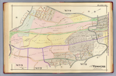
Full Title
Part of Yonkers. Plate 1. (A.H. Mueller, lith., Philada., 1907)
List No
0650.002
Note
Hand colored map. Maps in this atlas show buildings by construction material (stone, brick, frame, iron) with name or function, landowners, fire hydrants, water and sewer pipes, railroads, paved, unpaved and unopened streets, aqueducts and city and ward boundaries. Includes Saint Johns Riverside Hospital.
Full Title
Part of Yonkers. Plate 2. (A.H. Mueller, lith., Philada., 1907)
List No
0650.003
Note
Hand colored map. Maps in this atlas show buildings by construction material (stone, brick, frame, iron) with name or function, landowners, fire hydrants, water and sewer pipes, railroads, paved, unpaved and unopened streets, aqueducts and city and ward boundaries. Includes Manor Hall, Warburton Hall, First Presbyterian Church, Westminster Church, First M.E. Church, Yonkers Station, Peenes Wharf and Otis Elevator Company.
Full Title
Part of Yonkers. Plate 3. (A.H. Mueller, lith., Philada., 1907)
List No
0650.004
Note
Hand colored map. Maps in this atlas show buildings by construction material (stone, brick, frame, iron) with name or function, landowners, fire hydrants, water and sewer pipes, railroads, paved, unpaved and unopened streets, aqueducts and city and ward boundaries. Includes Washington Park, Getty Square, Saint Johns P.E. Church, Saint Josephs Hospital, National Sugar Refining Company, Federal Sugar Refining Company and Waring Hat Manufacturing Company.
Full Title
Part of Yonkers. Plate 4. (A.H. Mueller, lith., Philada., 1907)
List No
0650.005
Note
Hand colored map. Maps in this atlas show buildings by construction material (stone, brick, frame, iron) with name or function, landowners, fire hydrants, water and sewer pipes, railroads, paved, unpaved and unopened streets, aqueducts and city and ward boundaries. Includes Federal Sugar Refining Company, Saint Peters R.C. Church and Park Hill Reformed Church.
Full Title
Part of Yonkers. Plate 5. (A.H. Mueller, lith., Philada., 1907)
List No
0650.006
Note
Hand colored map. Maps in this atlas show buildings by construction material (stone, brick, frame, iron) with name or function, landowners, fire hydrants, water and sewer pipes, railroads, paved, unpaved and unopened streets, aqueducts and city and ward boundaries. Includes Yonkers City Ice Company and Saint Andrews Episcopal Church.
Full Title
Part of Yonkers. Plate 6. (A.H. Mueller, lith., Philada., 1907)
List No
0650.007
Note
Hand colored map with inset. Maps in this atlas show buildings by construction material (stone, brick, frame, iron) with name or function, landowners, fire hydrants, water and sewer pipes, railroads, paved, unpaved and unopened streets, aqueducts and city and ward boundaries. Includes Leake and Watts Orphan House, B'nai B'rith Benevolent Society Home for the Aged and Infirm, Van Cortlandt Terrace, Rockledge and Lowerre Station.
Full Title
Part of Yonkers. Plate 7. (A.H. Mueller, lith., Philada., 1907)
List No
0650.008
Note
Hand colored map. Relief shown by hachures. Maps in this atlas show buildings by construction material (stone, brick, frame, iron) with name or function, landowners, fire hydrants, water and sewer pipes, railroads, paved, unpaved and unopened streets, aqueducts and city and ward boundaries. Includes Park Hill.
Full Title
Part of Yonkers. Plate 8. (A.H. Mueller, lith., Philada., 1907)
List No
0650.009
Note
Hand colored map. Maps in this atlas show buildings by construction material (stone, brick, frame, iron) with name or function, landowners, fire hydrants, water and sewer pipes, railroads, paved, unpaved and unopened streets, aqueducts and city and ward boundaries. Includes Saint Casimirs R.C. Church, Day Spring Presbyterian Church, Arlington Chemical Company and Alexander Smith and Sons Carpet Company.
Full Title
Part of Yonkers. Plate 9. (A.H. Mueller, lith., Philada., 1907)
List No
0650.010
Note
Hand colored map. Maps in this atlas show buildings by construction material (stone, brick, frame, iron) with name or function, landowners, fire hydrants, water and sewer pipes, railroads, paved, unpaved and unopened streets, aqueducts and city and ward boundaries. Includes Oakland Cemetery, Saint Johns Cemetery, Grant Park and Homeopathic Hospital.
Full Title
Part of Yonkers. Plate 10. (A.H. Mueller, lith., Philada., 1907)
List No
0650.011
Note
Hand colored map. Maps in this atlas show buildings by construction material (stone, brick, frame, iron) with name or function, landowners, fire hydrants, water and sewer pipes, railroads, paved, unpaved and unopened streets, aqueducts and city and ward boundaries. Includes Lake Avenue Reservoir, Amackassin Heights and Sacred Heart Monastery.
Full Title
Part of Yonkers. Plate 11. (A.H. Mueller, lith., Philada., 1907)
List No
0650.012
Note
Hand colored map. Maps in this atlas show buildings by construction material (stone, brick, frame, iron) with name or function, landowners, fire hydrants, water and sewer pipes, railroads, paved, unpaved and unopened streets, aqueducts and city and ward boundaries. Includes Irving Park, Glenwood Station and the India Rubber and Gutta Percha Insulating Company.
Full Title
Part of Yonkers. Plate 12. (A.H. Mueller, lith., Philada., 1907)
List No
0650.013
Note
Hand colored map. Maps in this atlas show buildings by construction material (stone, brick, frame, iron) with name or function, landowners, fire hydrants, water and sewer pipes, railroads, paved, unpaved and unopened streets, aqueducts and city and ward boundaries. Includes Yonkers Heights, Morsemere, Upland Park, Greystone Park, Brookside Park, Fairmount, Weston Park and Elizabeth Place.
Full Title
Part of Yonkers. Plate 13. (A.H. Mueller, lith., Philada., 1907)
List No
0650.014
Note
Hand colored map. Maps in this atlas show buildings by construction material (stone, brick, frame, iron) with name or function, landowners, fire hydrants, water and sewer pipes, railroads, paved, unpaved and unopened streets, aqueducts and city and ward boundaries. Includes Greystone Station, Harriman and Hawleys Subdivision and Nepera Park.
Full Title
Part of Yonkers. Plate 14. (A.H. Mueller, lith., Philada., 1907)
List No
0650.015
Note
Hand colored map. Maps in this atlas show buildings by construction material (stone, brick, frame, iron) with name or function, landowners, fire hydrants, water and sewer pipes, railroads, paved, unpaved and unopened streets, aqueducts and city and ward boundaries. Includes Nepera Park Station and Post Office, Greystone Station and Saint Joseph's R.C. Cemetery.
Full Title
Part of Yonkers. Plate 15. (A.H. Mueller, lith., Philada., 1907)
List No
0650.016
Note
Hand colored map with inset. Maps in this atlas show buildings by construction material (stone, brick, frame, iron) with name or function, landowners, fire hydrants, water and sewer pipes, railroads, paved, unpaved and unopened streets, aqueducts and city and ward boundaries. Includes Grassy Springs Reservoir.
Full Title
Part of Yonkers. Plate 16. (A.H. Mueller, lith., Philada., 1907)
List No
0650.017
Note
Hand colored map. Relief shown by hachures. Maps in this atlas show buildings by construction material (stone, brick, frame, iron) with name or function, landowners, fire hydrants, water and sewer pipes, railroads, paved, unpaved and unopened streets, aqueducts and city and ward boundaries. Includes Grassy Sprain Reservoir, Sprain Ridge Hospital, Gray Oaks Station, City Hospital and Saint Mary's R.C. Cemetery.
Full Title
Part of Yonkers. Plate 17. (A.H. Mueller, lith., Philada., 1907)
List No
0650.018
Note
Hand colored map. Maps in this atlas show buildings by construction material (stone, brick, frame, iron) with name or function, landowners, fire hydrants, water and sewer pipes, railroads, paved, unpaved and unopened streets, aqueducts and city and ward boundaries. Includes Oakland Cemetery, Saint Johns Cemetery, Dunwoodie Country Club, Fortfield Reservoir, Hillside Park, North Palmer Heights, South Palmer Heights, Nepperhan Heights, Moquette Park and Nepperhan Station.
Full Title
Part of Yonkers. Plate 18. (A.H. Mueller, lith., Philada., 1907)
List No
0650.019
Note
Hand colored map. Maps in this atlas show buildings by construction material (stone, brick, frame, iron) with name or function, landowners, fire hydrants, water and sewer pipes, railroads, paved, unpaved and unopened streets, aqueducts and city and ward boundaries. Includes Lincoln Station, Dunwoodie Station, Van Cortlandt Park North, Lincoln Park, Lowerre Summit and Park Hill South.
Full Title
Part of Yonkers. Plate 19. (A.H. Mueller, lith., Philada., 1907)
List No
0650.020
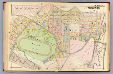
Note
Hand colored map. Maps in this atlas show buildings by construction material (stone, brick, frame, iron) with name or function, landowners, fire hydrants, water and sewer pipes, railroads, paved, unpaved and unopened streets, aqueducts and city and ward boundaries. Includes Wakefield Station, Richmond Park and Wakefield Park.
Full Title
Part of Yonkers. Plate 20. (A.H. Mueller, lith., Philada., 1907)
List No
0650.021
Note
Hand colored map. Maps in this atlas show buildings by construction material (stone, brick, frame, iron) with name or function, landowners, fire hydrants, water and sewer pipes, railroads, paved, unpaved and unopened streets, aqueducts and city and ward boundaries. Includes Empire City Park, Shearwood Hill, Sherwood Park, Belmont and West Mount Vernon Station.
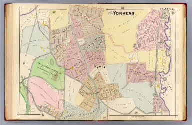
Full Title
Part of Yonkers. Plate 21. (A.H. Mueller, lith., Philada., 1907)
List No
0650.022
Note
Hand colored map. Maps in this atlas show buildings by construction material (stone, brick, frame, iron) with name or function, landowners, fire hydrants, water and sewer pipes, railroads, paved, unpaved and unopened streets, aqueducts and city and ward boundaries. Includes Saint Josephs Seminary, Glen Washington, Glen Washington Park, Gunther Estate, Sunnyside Park and Lincoln Heights.
Full Title
Part of Yonkers. Plate 22. (A.H. Mueller, lith., Philada., 1907)
List No
0650.023
Note
Hand colored map. Maps in this atlas show buildings by construction material (stone, brick, frame, iron) with name or function, landowners, fire hydrants, water and sewer pipes, railroads, paved, unpaved and unopened streets, aqueducts and city and ward boundaries. Includes Bryn Mawr Park Station, Armour Villa Park, Bronxville Park, Glen Washington, Bronx Manor and South Bronxville.
Full Title
Part of Yonkers. Plate 23. (A.H. Mueller, lith., Philada., 1907)
List No
0650.024
Note
Hand colored map. Maps in this atlas show buildings by construction material (stone, brick, frame, iron) with name or function, landowners, fire hydrants, water and sewer pipes, railroads, paved, unpaved and unopened streets, aqueducts and city and ward boundaries. Includes Grassy Sprain Reservoir, Mohegan Park, Crestwood, Yonkers Park, Yonkers Park Station and Tuckahoe Station.
Full Title
Part of Yonkers. Plate 24. (A.H. Mueller, lith., Philada., 1907)
List No
0650.025
Note
Hand colored map. Maps in this atlas show buildings by construction material (stone, brick, frame, iron) with name or function, landowners, fire hydrants, water and sewer pipes, railroads, paved, unpaved and unopened streets, aqueducts and city and ward boundaries. Includes Monrovia Park, Cegil Park and Saint Eleanora's Home.
|