|
Author
[Turner, S.J., Daily Herald]
Full Title
Color Relief Map of Abyssinia and War Zone : specially drawn for the Daily Herald. (by) S.J. Turner.
List No
6777.000
Note
Color relief map by S.J. Turner representing a bird's eye view from space encompassing a wide swath of the globe from Italian Somaliland at the lower edge of the map to Morocco and Italy at the upper edge of the map, just below a distant horizon of the earth's curvature. The style brings to mind the work of Richard Edes Harrison who used this "aviation age" cartography to great effect during World War II. As with the maps of Harrison, the perspective emphasises the proximity of areas than might appear further removed on a "conventional" map - an important realisation when times of crisis. On the map it is noted that "This map is divided into 200-MILE SQUARES shown in perspective." Shows international boundaries, railways. major cities, and rivers. Includes European possession in Africa. Relief shown by shadings.
Author
Suchy, Arthur B. (1901-1995)
Full Title
(Covers to) The heart of Cleveland, Ohio. Forest City. Cleveland, Ohio. 1928. (Copyright) by Arthur B. Suchy. The Du Bois Press, Rochester, N.Y. "Scale street layout 13 1/2 inches to 1 mile. buildings, figures and the rest have no scale".
List No
6778.001
Note
Cover to the color pictorial map, folded into original decorative envelope, 20.5x19, with title: The heart of Cleveland, Ohio. Forest City. Cleveland 1796. Detailed map, shows city blocks, landmark buildings, steam ship, roads, railroads, rivers and mountains. Includes inset vignettes of Gen. Moses Cleveland, the founder of Cleveland, Ohio, and description to each buildings and landmark, with the hamlet of Bockhampton, Hardy's birthplace, marked just to the east of the town and Weymouth to the south. The map is decorated with a orange, blue and brown compass. Includes directory to pints of interest, text and notes.
Author
Suchy, Arthur B. (1901-1995)
Full Title
The heart of Cleveland, Ohio. Forest City. Cleveland, Ohio. 1928. (Copyright) by Arthur B. Suchy. The Du Bois Press, Rochester, N.Y. "Scale street layout 13 1/2 inches to 1 mile. buildings, figures and the rest have no scale".
List No
6778.002
Note
Color pictorial map, folded into original decorative envelope, 20.5x19, with title: The heart of Cleveland, Ohio. Forest City. Cleveland 1796. Detailed map, shows city blocks, landmark buildings, steam ship, roads, railroads, rivers and mountains. Includes inset vignettes of Gen. Moses Cleveland, the founder of Cleveland, Ohio, and description to each buildings and landmark, with the hamlet of Bockhampton, Hardy's birthplace, marked just to the east of the town and Weymouth to the south. The map is decorated with a orange, blue and brown compass. Includes directory to pints of interest, text and notes.
Author
Mexico National R.R.
Full Title
January 1902. Mexico National R.R. Loredo Route ... Short Line to Monterey, Saltillo, San Luis Potosi, San Miguel de Allende, Celaya, Morelia, Patzcuaro, Toluca, City of Mexico and Points South.
List No
6779.001
Author
Mexico National R.R.
Full Title
(Text Page) (Schedules, Fares, etc.) Mexico National R.R. Loredo Route ... Short Line to Monterey, Saltillo, San Luis Potosi, San Miguel de Allende, Celaya, Morelia, Patzcuaro, Toluca, City of Mexico and Points South.
List No
6779.002
Author
Mexico National R.R.
Full Title
Map of the Mexico National R.R. Loredo Route and Connections. The Scenic Short Line to the City of Mexico.
List No
6779.003
Author
[General Drafting Company, Standard Oil]
Full Title
(Covers to) Pictorial Map of the Americas featuring the Pan American Highway.
List No
6780.001
Note
Date estimated. Covers are two panels
Author
[General Drafting Company, Standard Oil]
Full Title
(Text Page) Know Your Neighbors Better.
List No
6780.002
Note
Date estimated. Text: "Know Your Neighbors Better" with information on countries in the Americas.
Author
[General Drafting Company, Standard Oil]
Full Title
Pictorial Map of the Americas featuring the Pan American Highway.
List No
6780.003
Note
Date estimated. Pictographic map showing the Americas from Greenland through South America with illustrations of animals, plants, industry, agriculture, and points of interest.
Author
Alcoa Map Department, Aluminum Company of America
Full Title
(Covers to) Global Map for Global War and Global Peace. Vacations for All.
List No
6781.001
Note
Cover is one panel of folding map. Includes diagram showing the shrinking of the earth to show circumnavigation times in 1872, 1903, and 1938.
Author
Alcoa Map Department, Aluminum Company of America
Full Title
(Diagrams) (Aircraft Profiles. Aircraft Maneuvers. Military Insignia. Types of Aluminum. Aircraft Construction Details).
List No
6781.002
Author
Alcoa Map Department, Aluminum Company of America
Full Title
Global Map for Global War and Global Peace.
List No
6781.003
Note
Map border has aircraft insignia for nations of the world, a table of air lines distances (worldwide), illustrations of the "flying boat" and a bomber, and map information. Map is the world as viewed from a north polar projection (Azimuthal Equidistant Projection). A pitch advocating "Freedom of the Air" and it benefits to mankind is given on the map.
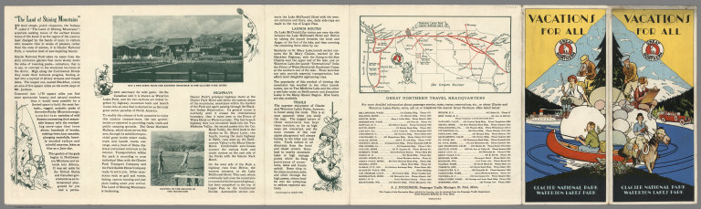
Author
Scheuerle, Joe (1873-1948)
Full Title
(Covers to) Great Northern Recreational Map of Glacier National Park Montana, Waterton Lakes National Park Alberta.
List No
6782.001
Note
Date estimated. Cover title: "Vacations for All, Great Northern, Glacier National Park, Waterton Lakes Park."
Author
Scheuerle, Joe (1873-1948)
Full Title
(Text Page) Great Northern Recreational Map of Glacier National Park Montana, Waterton Lakes National Park Alberta.
List No
6782.002
Note
Date estimated. Text describes area and activities. Humorous illustrations and photographs of scenic highlights.
Author
Scheuerle, Joe (1873-1948)
Full Title
(Text Page) Great Northern Recreational Map of Glacier National Park Montana, Waterton Lakes National Park Alberta.
List No
6782.003
Note
Date estimated. Text describes area and activities. Humorous illustrations and photographs of scenic highlights.
Author
Scheuerle, Joe (1873-1948)
Full Title
Great Northern Recreational Map of Glacier National Park Montana, Waterton Lakes National Park Alberta.
List No
6782.004
Note
Date estimated. Humorous illustrations on an attractive background map of Montana and adjacent Canada. A handsome bird's eye view style pictorial map by Joseph Scheuerle, brightly colored and humorous. Here the emphasis is on recreational possibilities for the Caucasian tourist, including golf, swimming, tennis, fishing. In front of the title cartouche at lower right is a group of Native American Indians with the artist and canvas at the very right hand corner.
Author
Rand McNally & Co.
Full Title
(Covers to) Map of United States Military Posts.
List No
6783.001
Note
Folded. Covers from two panels on back of map.
Author
Rand McNally & Co.
Full Title
(Text Page) List of United States Military Posts. Army and Navy Plane Silhouettes. USO Clubs.
List No
6783.002
Author
Rand McNally & Co.
Full Title
Rand McNally Map of United States Military Posts.
List No
6783.003
Author
[Lane, John J., New England Street Railway Club]
Full Title
(Covers to)Trolley Wayfinder : birds eye view of trolley routes in New England. Published by the New England street Railway Club. ... John J. Lane Editor of "Trolley Wayfinder" and Trolley Wayfinder birds eye view of trolley routes. 12 Paerl St. Boston. Copyright 1904, 1905, 1906 & 1907 by the New England Street Railway Club.Price 10 Cents. (with) Trolley Wayfinder : birds eye view of trolley routes in New England. New England street Railway Club ... Geo. H. Walker & Co. Boston. (with 7 insets).
List No
6784.001
Note
Color view, 52x 35, folded in cover 19 x 10. Covers eastern Massachusetts excluding Cape Cod; extends west to Worcester, east to Plymouth, north to southern New Hampshire and southern Maine, and south to Providence and Newport. Insets: (Boston and vicinity). (with) Portsmouth and Lewiston. (with) Springfield to Turners Falls. (with) Worcester to Springfield. (with) Springfield to New York City. (with) Pittsfield and vicinity. (with) Rochester [N.H.] to Nashua. (with) A triangle route; Worcester to Providence to New London. Text, map and advertisements on verso of map, back cover and inside front cover. Relief shown pictorially.
Author
[Lane, John J., New England Street Railway Club]
Full Title
(Text Page to)Trolley Wayfinder : birds eye view of trolley routes in New England. New England street Railway Club. 12 Pearl St. Copyright 1904, 1905, 1906, 1907, by the New England Street Railway Club. Geo. H. Walker & Co. Boston. (with 7 insets). (cover title) Trolley Wayfinder : birds eye view of trolley routes in New England. Published by New England street Railway Club. ... John J. Lane Editor of "Trolley Wayfinder" and Trolley Wayfinder birds eye view of trolley routes. Price 10 Cents.
List No
6784.002
Note
On verso of "Birds eye view of trolley routes in New England". Advertisement, text, and untitled map of Cape Porpoise deep-sea fishing ..."
Author
[Lane, John J., New England Street Railway Club]
Full Title
Trolley Wayfinder : birds eye view of trolley routes in New England. New England street Railway Club. 12 Pearl St. Copyright 1904, 1905, 1906, 1907, by the New England Street Railway Club. Geo. H. Walker & Co. Boston. (with 7 insets). (cover title) Trolley Wayfinder : birds eye view of trolley routes in New England. Published by New England street Railway Club. ... John J. Lane Editor of "Trolley Wayfinder" and Trolley Wayfinder birds eye view of trolley routes. Price 10 Cents.
List No
6784.003
Note
Color view, 52x 35, folded in cover 19 x 10. Covers eastern Massachusetts excluding Cape Cod; extends west to Worcester, east to Plymouth, north to southern New Hampshire and southern Maine, and south to Providence and Newport. Insets: (Boston and vicinity). (with) Portsmouth and Lewiston. (with) Springfield to Turners Falls. (with) Worcester to Springfield. (with) Springfield to New York City. (with) Pittsfield and vicinity. (with) Rochester [N.H.] to Nashua. (with) A triangle route; Worcester to Providence to New London. Text, map and advertisements on verso of map, back cover and inside front cover. Relief shown pictorially.
Author
[Young, Arthur S., Chichester, Francis]
Full Title
(Covers to) London to Paris : This passenger - amusement map has been specially produced and published for British European Airways by Francis Chichester, 9 St. James's Place, London, S.W. 1. Arthist- Arthur S. Young. Printed by Harrison & Sons, Ltd., London and High Wycombe. (on lower left margin) BEA 311 (100M). (Cover title) Keyline Maps : BEA London - Paris British European Airways : Picture map; The key to Europe.
List No
6785.001
Note
Covers to pictorial map folded in cover to 21x11. Show BEA routes, major cities and landmarks including explanations and notes to each location. Also includes legend and list of BEA booking offices and advertisement on verso of front and back covers.
Author
[Young, Arthur S., Chichester, Francis]
Full Title
London to Paris : This passenger - amusement map has been specially produced and published for British European Airways by Francis Chichester, 9 St. James's Place, London, S.W. 1. Arthist- Arthur S. Young. Printed by Harrison & Sons, Ltd., London and High Wycombe. (on lower left margin) BEA 311 (100M). (Cover title) Keyline Maps : BEA London - Paris British European Airways : Picture map; The key to Europe.
List No
6785.002
Note
Pictorial map folded in cover to 21x11. Show BEA routes, major cities and landmarks including explanations and notes to each location. Also includes legend and list of BEA booking offices and advertisement on verso of front and back covers.
Author
Lindgren, Jolly
Full Title
(Covers to) A Hysterical Map of Death Valley National Monument and It's Lookin' Mighty Low.
List No
6786.001
Note
Envelope labeled, "Here's Another Hysterical Map".
Author
Lindgren, Jolly
Full Title
A Hysterical Map of Death Valley National Monument and It's Lookin' Mighty Low.
List No
6786.002
Author
[Lites, Arthur, (Palo Alto) Chamber of Commerce]
Full Title
(Covers to) A Pictorial Map of Palo Alto and San Francisco Peninsula by Arthur Lites. Palo Alto, California. A Pictorial Map. Home of Stanford University.
List No
6787.001
Note
Date estimated. Front panel features a group of Spanish travelers looking upward at the "palo alto" or the "tall tree".
Author
[Lites, Arthur, (Palo Alto) Chamber of Commerce]
Full Title
(Text Page) A Pictorial Map of Palo Alto and San Francisco Peninsula by Arthur Lites. Palo Alto, California. A Pictorial Map. Home of Stanford University.
List No
6787.002
Note
Date estimated. Describes Palo Alto community emphasizing climate, Stanford University and Spanish/Mexican history.
Author
[Lites, Arthur, (Palo Alto) Chamber of Commerce]
Full Title
A Pictorial Map of Palo Alto and San Francisco Peninsula by Arthur Lites.
List No
6787.003
Note
Date estimated. A birdseye view map "drawn from the viewpoint of one aboard a United States Navy Dirigible" is bordered by vignette illustrations including a dirigible balloon or blimp at top right, "U.S. Naval Air Station at Sunnyvale Chosen for Favorable Climate". Other vignettes include "A Recreational Center on the Bay Front Under Construction" "Community Theatre", Stanford University buildings, California Redwood Park etc, with an historical figure in each corner. Map shows the buildings of Palo Alto and Stanford University, with San Francisco, Oakland and Berkeley at upper left, and Santa Clara and San Jose at right of center.
Author
Lindgren Brothers
Full Title
A Hysterical Map of the Yellowstone Park with Apologies to the Park. Smileage Guaranteed. Lindgren Brothers. Spokane, Wash. C(opyright)1936.
List No
6788.000
Note
Color pictorial map. Humorous pictorial map "hatched & scratched by Jolly Lindgren" featuring the highlights of a visit to the park: showing hotels, peaks, lakes, geysers, etc. Relief shown pictorially and by spot heights. In 1933 the Lindgren Brothers of Spokane, Washington began manufacturing colorful silk-screened maps depicting iconic national parks and other scenic areas. With emphasis on both verbal and visual humor, they titled these inexpensive tourist souvenirs "Hysterical Maps," seeking to distinguish them from historical maps.
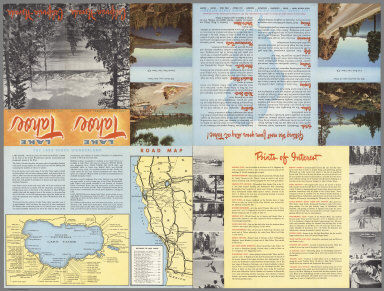
Author
Eddy, Gerald A.
Full Title
(Covers to) Lake Tahoe - Sierra Association. California -- Nevada.
List No
6789.001
Note
Date estimated. Covers two panels of folded map - form a single picture.
Author
Eddy, Gerald A.
Full Title
(Text Page) Lake Tahoe - Sierra Association. California -- Nevada.
List No
6789.002
Note
Date estimated. Includes two maps, numerous photographs, and travel points of interest and tips.
Author
Eddy, Gerald A.
Full Title
Lake Tahoe - Sierra Association. California -- Nevada.
List No
6789.003
Note
Date estimated. See Pub Note.
Author
Atwood, Mary Hall (1894-1950)
Full Title
(Covers to) The Tenth Olympic Games Los Angeles, California, July 30 - Aug. 14 '32. Designed and Illustrated by Mary Hall Atwood. A Complete Map of Los Angeles Area and Guide to Olympic Games.
List No
6790.001
Author
Atwood, Mary Hall (1894-1950)
Full Title
(Text Page) The Tenth Olympic Games Los Angeles, California, July 30 - Aug. 14 '32.
List No
6790.002
Note
Includes Olympic Games History, General Program - Tenth Olympic Games - Los Angeles - 1932, and The Olympic City 1932.
Author
Atwood, Mary Hall (1894-1950)
Full Title
The Tenth Olympic Games Los Angeles, California, July 30 - Aug. 14 '32. Designed and Illustrated by Mary Hall Atwood. A Complete Map of Los Angeles Area and Guide to Olympic Games.
List No
6790.003
Note
Strip maps on margins. Olympic venues described and mapped. The full sheet map is a schematic bird's eye view style map of the Greater Los Angeles area with Olympic venues marked eg. bicycle start and finish, rowing course, Olympic village. The attractive border shows routes to Los Angeles from the north, south and east with pictographs of the sights along the routes. The smaller pictorial map titled "The Olympic City 1932" shows vignette map illustrations of various Olympic venues; on the other half sheet is information on Olympic Games history, and a schedule of the games.
Author
[Lites, Arthur, (Palo Alto) Chamber of Commerce]
Full Title
(Covers to) A Pictorial Map of Palo Alto and San Francisco Peninsula by Arthur Lites. Palo Alto, California. A Pictorial Map. Home of Stanford University.
List No
6791.001
Note
Date estimated. Front panel features a group of Spanish travelers looking upward at the "palo alto" or the "tall tree".
Author
[Lites, Arthur, (Palo Alto) Chamber of Commerce]
Full Title
(Text Page) A Pictorial Map of Palo Alto and San Francisco Peninsula by Arthur Lites. Palo Alto, California. A Pictorial Map. Home of Stanford University.
List No
6791.002
Note
Date estimated. Describes Palo Alto community emphasizing climate, Stanford University and Spanish/Mexican history.
Author
[Lites, Arthur, (Palo Alto) Chamber of Commerce]
Full Title
A Pictorial Map of Palo Alto and San Francisco Peninsula by Arthur Lites.
List No
6791.003
Note
Date estimated. A birdseye view map bordered by vignette illustrations including "A Recreational Center on the Bay Front Under Construction" "Community Theatre", Stanford University buildings, California Redwood Park etc., with an historical figure in each corner. Map shows the buildings of Palo Alto and Stanford University.
Author
[Lites, Arthur, (Palo Alto) Chamber of Commerce]
Full Title
(Covers to) A Pictorial Map of Palo Alto and San Francisco Peninsula by Arthur Lites. Palo Alto, California. A Pictorial Map. Home of Stanford University.
List No
6792.001
Note
Date estimated. Front panel features a group of Spanish travelers looking upward at the "palo alto" or the "tall tree".
Author
[Lites, Arthur, (Palo Alto) Chamber of Commerce]
Full Title
(Text Page) A Pictorial Map of Palo Alto and San Francisco Peninsula by Arthur Lites. Palo Alto, California. A Pictorial Map. Home of Stanford University.
List No
6792.002
Note
Date estimated. Describes Palo Alto community emphasizing climate, Stanford University and Spanish/Mexican history.
Author
[Lites, Arthur, (Palo Alto) Chamber of Commerce]
Full Title
A Pictorial Map of Palo Alto and San Francisco Peninsula by Arthur Lites.
List No
6792.003
Note
Date estimated. A birdseye view map bordered by vignette illustrations including "A Recreational Center on the Bay Front Under Construction" "Community Theatre", Stanford University buildings, California Redwood Park etc., with an historical figure in each corner. Map shows the buildings of Palo Alto and Stanford University.
Author
Chase, Ernest Dudley, 1878-1966
Full Title
World Wonders, A Pictorial Map. Designed and Drawn by Ernest Dudley Chase of Winchester, Mass.
List No
6794.000
Note
Innumerable vignettes of structures, ships, activities, and scenery.
Author
Chase, Ernest Dudley, 1878-1966
Full Title
Moore-McCormack Lines Pictorial Map of South America. Copyright 1942, Ernest Dudley Chase. Lithographed in the U.S.A. by Rand McNally & Company, Chicago.
List No
6795.000
Note
Color pictorial map. A most attractively designed map by Ernest Dudley Chase, the cartouche featuring intricately drawn vignette images of important buildings, scenic spots in South America and portrait of Simon Bolivar. In addition, on the map there are small vignettes featuring the attractions of the countries: Peru, Equador, Venezuela, Colombia,Brazil, Argentina, Chile, Paraguay, Uruguay, Bolivia, British, Dutch, and French Guiana. Shows Moore-McCormack cruise routes from New York to South America. The map is decorated with pink, black and yellow compass. Relief shown pictorially.
Author
Chase, Ernest Dudley, 1878-1966
Full Title
A pictorial map of North America : designed, drawn and published by Ernest Dudley Chase, Winchester, Massachusetts, U.S.A. Copyright 1945, Ernest Dudley Chase, Winchester, Mass. Printed in U.S.A.
List No
6796.000
Note
Pictorial map of the North American continent, from Greenland in the north to Panama in the south. The map is filled with drawings of buildings, landmarks and wildlife. Along the right and left margins are vignette images of important buildings and scenic spots in Canada, the United States, Mexico, Guatemala, Honduras, Panama and Cuba. In addition, on the map there are small pictographs featuring the attractions of the countries: Greenland, Iceland, Canada, the United States, Mexico, Guatemala, Honduras, Salvador, Nicaragua, Costa Rica, Panama. Geographical features include national boundaries, capitals, states and provinces, major cities, rivers and other large bodies of water. The map is decorated with a red, yellow and black compass rose and an Art Deco geometric border design. Relief shown pictorially. Includes text.
Author
Chase, Ernest Dudley, 1878-1966
Full Title
A Pictorial Map of the New England States U.S.A. Designed and Drawn by Ernest Dudley Chase of Winchester, Mass.
List No
6797.000
Note
Innumerable vignettes of structures, ships, activities, and scenery.
Author
Chase, Ernest Dudley, 1878-1966
Full Title
A Pictorial Map of Germany : by Ernest Dudley Chase of Winchester in Massachusetts. U.S.A. Copyright 1935, Ernest Dudley Chase.
List No
6798.000
Note
Pictographic map, with decorative border. Pencil signed by the artist Ernest Dudley Chase on lower left. Attractive and extraordinarily detailed map, shows landmark buildings with few exceptions, the image of a blimp, steam boats, rivers and mountains. Includes inset vignettes of historic architecture. The map is decorated with a red, yellow and brown compass. Relief shown pictorially.
Author
Menting
Full Title
KLM Royal Dutch Airlines. 1919 - 30th Year - 1949.
List No
6799.000
Note
Small pictographs depict characteristic features of the continents e.g. the Statue of Liberty, a kangaroo, camels, etc.
Author
[Andree, Richard, Times (London, England)]
Full Title
(Covers to) The Times Atlas ; (New Edition). Containing 132 Pages of Maps, and comprising 196 Maps and an Alphabetical Index to 150,000 Names. Published at the Office of The Times, Printing House Square, London, E.C. 1900.
List No
6809.001
Note
Second and New edition of The Times Atlas published in 1900 (see our 1895 first edition, 1010.000), containing 132 pages of maps and comprising 196 maps and an alphabetical index of 135,000 names. This is the English version of the German Andrees Handatlas, 3rd edition (1893-1897). In this 2nd. Times edition, some maps have been derived from the German Andree 4th edition. The 1900 printing, actually a completely new edition, was issued from 1899 in 24 weekly installments at 1 shilling each. The map size has increased and so has the binding: 30 × 45 cm. The 'luxury' binding has dark brown color, clock and oak leaves with gilt title, "The Times Atlas." It has leather spine and corners, a vertical title on the spine and pages with gilt edges. Most notable extensions in the 1900 edition are the geological maps of the British Isles, the showing of shipping routes, and the regional maps of the United States.
Author
[Andree, Richard, Times (London, England)]
Full Title
(Title Page to) The Times Atlas ; (New Edition). Containing 132 Pages of Maps, and comprising 196 Maps and an Alphabetical Index to 150,000 Names. Published at the Office of The Times, Printing House Square, London, E.C. 1900.
List No
6809.002
Note
Second and New edition of The Times Atlas published in 1900 (see our 1895 first edition, 1010.000), containing 132 pages of maps and comprising 196 maps and an alphabetical index of 135,000 names. This is the English version of the German Andrees Handatlas, 3rd edition (1893-1897). In this 2nd. Times edition, some maps have been derived from the German Andree 4th edition. The 1900 printing, actually a completely new edition, was issued from 1899 in 24 weekly installments at 1 shilling each. The map size has increased and so has the binding: 30 × 45 cm. The 'luxury' binding has dark brown color, clock and oak leaves with gilt title, "The Times Atlas." It has leather spine and corners, a vertical title on the spine and pages with gilt edges. Most notable extensions in the 1900 edition are the geological maps of the British Isles, the showing of shipping routes, and the regional maps of the United States.
|