Who What Where WhenWHAT
|
Author
[Roussin, Albin-Reine, baron, 1781-1854, Givry, Depot General de la Marine, Besançon]
Full Title
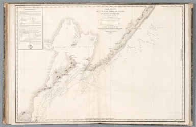
Carte réduite de la Côte du Brésil comprise entre le Cap Frio et Porto Seguro levée en 1819, dans la Campagne de la Corvette la Bayadère et du Brick le Favori, par Mm. Givry, Ingénieur-Hydrographe de la Marine, Chevalier de la Légion d'Honneur, et les Officiers des deux Batimens, sous les Ordres et la Direction de M. le Baron Roussin, Capitane de Vaisseau, Officier de la Légion d'Honneur, Chevalier de St. Louis et de St. Wolodimir de Russie, Chef de l'Expédition. Publiée par Ordre du Roi sous le Ministère de Son Exc. M. le Marquis de Clermont-Tonnerre Pair de France, Secrétaire d'Etat au Département de la Marine et des Colonies. Au Dépôt-général de la Marine, 1824. Dessinée par M. Givry et gravée par M. Ambroise Tardieu ; ecrit par Besançon.
List No
14364.033
Note
Map of the Brazilian coast between Cabo Frio and Porto Seguro, as surveyed in 1819. Shows cities, ports, topography, vegetation, drainage, coastline, bays, shoals, islands, depths, routes and anchorage. Relief shown with hachures. Includes latitudinal and longitudinal lines. With descriptive text and the seal of "Dépòt General de la Marine". Black and white engraving. Map is 89 x 59 cm, on double sheet 100 x 66 cm. Appears in Deuxième partie.
Author
[Roussin, Albin-Reine, baron, 1781-1854, Givry, Gressier, Charles-Louis, 1791-1886, Depot General de la Marine, Besançon]
Full Title
Plan de la Baie de Espirito Santo située à la Côte du Brésil, levé en 1819, dans la Campagne de la Corvette la Bayadère et du Brick le Favori, par Mm. Givry et Gressier, Ingénieurs-Hydrographe de la Marine et les Officiers des deux Batimens, sous les Ordres et la Direction de M. le Baron Roussin, Capitane de Vaisseau, Officier de la Légion d'Honneur, Chevalier de St. Louis et de St. Wolodimir de Russie, Chef de l'Expédition. Publiée par Ordre du Roi sous le Ministère de Son Exc. M. le Marquis de Clermont-Tonnerre Pair de France, Secrétaire d'Etat au Département de la Marine et des Colonies. Au Dépôt-général de la Marine, 1823. Gravé par M. Ambroise Tardieu ; ecrit par Besançon.
List No
14364.034
Note
Map of the Bay of Espírito Santo, on the Brazilian coast, as surveyed in 1819. Shows cities, forts, ports, topography, vegetation, drainage, coastline, bays, shoals, islands, depths, routes and anchorage. Relief shown with hachures. Includes a bar scale given in "milles marins" [= nautical miles]. With descriptive text and the seal of "Dépòt General de la Marine". Black and white engraving. Map is 42 x 58 cm, on sheet 50 x 66 cm. Appears in Deuxième partie.
Author
[Roussin, Albin-Reine, baron, 1781-1854, Givry, Depot General de la Marine, Besançon]
Full Title
Carte réduite des Ilots et du Canal des Abrolhos situés à la Côte du Brésil, levée en 1819, dans la Campagne de la Corvette la Bayadère et du Brick le Favori, par Mm. Givry, Ingénieur-Hydrographe de la Marine, Chevalier de la Légion d'Honneur, et les Officiers de la Corvette, sous les Ordres et la Direction de M. le Baron Roussin, Capitane de Vaisseau, Officier de la Légion d'Honneur, Chevalier de St. Louis et de St. Wolodimir de Russie, Chef de l'Expédition. Publiée par Ordre du Roi sous le Ministère de Son Exc. M. le Marquis de Clermont-Tonnerre Pair de France, Secrétaire d'Etat au Département de la Marine et des Colonies. Au Dépôt-général de la Marine, 1822. Gravé par M. Ambroise Tardieu ; ecrit par Besançon.
List No
14364.035
Note
Map of the Abrolhos Archipelago, on the Brazilian coast, as surveyed in 1819. Shows topography, vegetation, drainage, coastline, bays, shoals, islands, depths, routes and anchorage. Relief shown with hachures. Includes latitudinal and longitudinal lines, as well as a bar scale given in "toises" [= fathoms]. With descriptive text and the seal of "Dépòt General de la Marine". Inset map: Plan des Ilots Abrolhos. Black and white engraving. Map is 58 x 89 cm, on double sheet 66 x 100 cm. Appears in Deuxième partie.
Author
[Roussin, Albin-Reine, baron, 1781-1854, Givry, Depot General de la Marine, Besançon]
Full Title
Carte réduite de la Côte du Brésil comprise entre Porto Seguro et Pernambuco levée en 1819, dans la Campagne de la Corvette la Bayadère et du Brick le Favori, par Mm. Givry, Ingénieur-Hydrographe de la Marine, Chevalier de la Légion d'Honneur, et les Officiers des deux Batimens, sous les Ordres et la Direction de M. le Baron Roussin, Capitane de Vaisseau, Officier de la Légion d'Honneur, Chevalier de St. Louis et de St. Wolodimir de Russie, Chef de l'Expédition. Publiée par Ordre du Roi sous le Ministère de Son Excellence M. le Comte Carbol de Crousol Pair de France, Secrétaire d'Etat au Département de la Marine et des Colonies. Au Dépôt-général de la Marine, 1825. Gravé par M. Ambroise Tardieu ; ecrit par Besançon.
List No
14364.036
Note
Map of the Brazilian coast between Porto Seguro and Pernambuco, as surveyed in 1819. Shows cities, ports, topography, vegetation, drainage, coastline, bays, shoals, islands, depths, routes and anchorage. Relief shown with hachures. Includes latitudinal and longitudinal lines. With descriptive text and the seal of "Dépòt General de la Marine". Black and white engraving. Map is 89 x 59 cm, on double sheet 100 x 66 cm. Appears in Deuxième partie.
Author
[Roussin, Albin-Reine, baron, 1781-1854, Givry, Depot General de la Marine, Besançon]
Full Title
Carte réduite de la Baie de Todos os Santos et de ses attérages situés à la Côte du Brésil, levée en 1819, dans la Campagne de la Corvette la Bayadère et du Brick le Favori, par Mm. Givry, Ingénieur-Hydrographe de la Marine, Chevalier de la Légion d'Honneur, et les Officiers de la Corvette, sous les Ordres et la Direction de M. le Baron Roussin, Capitane de Vaisseau, Officier de la Légion d'Honneur, Chevalier de St. Louis et de St. Wolodimir de Russie, Chef de l'Expédition. Publiée par Ordre du Roi sous le Ministère de Son Exc. M. le Marquis de Clermont-Tonnerre Pair de France, Secrétaire d'Etat au Département de la Marine et des Colonies. Au Dépôt-général de la Marine, 1822. Gravé par M. Ambroise Tardieu ; ecrit par Besançon.
List No
14364.037
Note
Map of the Baía de Todos os Santos [All Saints Bay], Brazil, as surveyed in 1819. Shows cities, ports, topography, vegetation, drainage, coastline, bays, shoals, islands, depths, routes and anchorage. Relief shown with hachures. Includes latitudinal and longitudinal lines. With descriptive text and the seal of "Dépòt General de la Marine". Black and white engraving. Map is 61 x 90 cm, on double sheet 66 x 100 cm. Appears in Deuxième partie.
Author
[Roussin, Albin-Reine, baron, 1781-1854, Givry, Depot General de la Marine, Besançon]
Full Title
Carte réduite de la Rade de Pernambuco et de ses attérages situés à la Côte du Brésil, levée en 1819, dans la Campagne de la Corvette la Bayadère et du Brick le Favori, par Mm. Givry, Ingénieur-Hydrographe de la Marine, Chevalier de la Légion d'Honneur, et les Officiers de la Corvette, sous les Ordres et la Direction de M. le Baron Roussin, Capitane de Vaisseau, Officier de la Légion d'Honneur, Chevalier de St. Louis et de St. Wolodimir de Russie, Chef de l'Expédition. Publiée par Ordre du Roi sous le Ministère de Son Excellence M. le Comte Charbol de Crousol Pair de France, Secrétaire d'Etat au Département de la Marine et des Colonies. Au Dépôt-général de la Marine, en 1824. Dessinés par M. Givry et gravés par M. Ambroise Tardieu ; ecrit par Besançon.
List No
14364.038
Note
Map of Pernambuco, Brazil, as surveyed in 1819. Shows cities, ports, topography, vegetation, drainage, coastline, bays, shoals, islands, depths, routes and anchorage. Relief shown with hachures. Includes latitudinal and longitudinal lines. With descriptive text and the seal of "Dépòt General de la Marine". Black and white engraving. Map is 59 x 43 cm, on sheet 66 x 50 cm. Appears in Deuxième partie.
Author
[Roussin, Albin-Reine, baron, 1781-1854, Gressier, Charles-Louis, 1791-1886, Givry, Depot General de la Marine, Besançon]
Full Title
Plan de la Rade de Pernambuco levé en 1819, dans la Campagne de la Corvette la Bayadère et du Brick le Favori, par Mm. Gressier, Ingénieur-Hydrographe de la Marine, et les Officiers du Brick, sous les Ordres et la Direction de M. le Baron Roussin, Capitane de Vaisseau, Officier de la Légion d'Honneur, Chevalier de St. Louis et de St. Wolodimir de Russie, Chef de l'Expédition. Publiée par Ordre du Roi sous le Ministère de Son Excellence M. le Comte Charbol de Crousol Pair de France, Secrétaire d'Etat au Département de la Marine et des Colonies. Au Dépôt-général de la Marine, en 1824. Dessinés par M. Givry et gravés par M. Ambroise Tardieu ; ecrit par Besançon.
List No
14364.039
Note
Map of Pernambuco, Brazil, as surveyed in 1819. Shows cities, forts, ports, topography, vegetation, drainage, coastline, bays, shoals, islands, depths, routes and anchorage. Relief shown with hachures. Includes latitudinal and longitudinal lines, as well as a bar scale given in "milles marins" [= nautical miles] and compass rose with north oriented toward top of sheet. With descriptive text and the seal of "Dépòt General de la Marine". Black and white engraving. Map is 55 x 44 cm, on sheet 66 x 50 cm. Appears in Deuxième partie.
Author
[Roussin, Albin-Reine, baron, 1781-1854, Givry, Depot General de la Marine, Besançon]
Full Title
Carte réduite de la Côte du Brésil comprise entre Pernambuco et Ciará, levée en 1819, dans la Campagne de la Corvette la Bayadère et du Brick le Favori, par Mm. Givry, Ingénieur-Hydrographe de la Marine, Chevalier de la Légion d'Honneur, et les Officiers des deux Batimens, sous les Ordres et la Direction de M. le Baron Roussin, Capitane de Vaisseau, Officier de la Légion d'Honneur, Chevalier de St. Louis et de St. Wolodimir de Russie, Chef de l'Expédition. Publiée par Ordre du Roi sous le Ministère de Son Excellence M. le Comte Charbol de Crousol Pair de France, Secrétaire d'Etat au Département de la Marine et des Colonies. Au Dépôt-général de la Marine, 1826. Gravé par M. Ambroise Tardieu ; ecrit par Besançon.
List No
14364.040
Note
Map of the Brazilian coast between Pernambuco and "Ciará", as surveyed in 1819. Shows cities, ports, topography, vegetation, drainage, coastline, bays, shoals, islands, depths, routes and anchorage. Relief shown with hachures. Includes latitudinal and longitudinal lines. With descriptive text and the seal of "Dépòt General de la Marine". Black and white engraving. Map is 58 x 88 cm, on double sheet 66 x 100 cm. Appears in Deuxième partie.
Author
[Roussin, Albin-Reine, baron, 1781-1854, Givry, Depot General de la Marine, Besançon]
Full Title
Carte réduite de la Côte du Brésil comprise entre Ciará et Maranham, levée en 1819 et 1820, dans la Campagne de la Corvette la Bayadère et du Brick le Favori, par Mm. Givry, Ingénieur-Hydrographe de la Marine, Chevalier de la Légion d'Honneur, et les Officiers de la Corvette, sous les Ordres et la Direction de M. le Baron Roussin, Capitane de Vaisseau, Officier de la Légion d'Honneur, Chevalier de St. Louis et de St. Wolodimir de Russie, Chef de l'Expédition. Publiée par Ordre du Roi sous le Ministère de Son Excellence M. le Comte Charbol de Crousol Pair de France, Secrétaire d'Etat au Département de la Marine et des Colonies. Au Dépôt-général de la Marine, 1826. Gravé par M. Ambroise Tardieu ; ecrit par Besançon.
List No
14364.041
Note
Map of the Brazilian coast between "Ciará" and Maranhão, as surveyed in 1819 and 1820. Shows cities, ports, topography, vegetation, drainage, coastline, bays, shoals, islands, depths, routes and anchorage. Relief shown with hachures. Includes latitudinal and longitudinal lines. With descriptive text and the seal of "Dépòt General de la Marine". Black and white engraving. Map is 58 x 89 cm, on double sheet 66 x 100 cm. Appears in Deuxième partie.
Author
[Roussin, Albin-Reine, baron, 1781-1854, Givry, Depot General de la Marine, Besançon]
Full Title
Carte réduite des attérages du Port de Maranham situés à la Côte du Brésil, levée en 1820, dans la Campagne de la Corvette la Bayadère et du Brick le Favori, par Mm. Givry, Ingénieur-Hydrographe de la Marine, Chevalier de la Légion d'Honneur, et les Officiers de la Corvette, sous les Ordres et la Direction de M. le Baron Roussin, Capitane de Vaisseau, Officier de la Légion d'Honneur, Chevalier de St. Louis et de St. Wolodimir de Russie, Chef de l'Expédition. Publiée par Ordre du Roi sous le Ministère de Son Excellence M. le Comte Charbol de Crousol Pair de France, Secrétaire d'Etat au Département de la Marine et des Colonies. Au Dépôt-général de la Marine en 1826. Gravé par M. Ambroise Tardieu ; ecrit par Besançon.
List No
14364.042
Note
Map of Maranhão, on the Brazilian coast, as surveyed in 1820. Shows cities, ports, topography, vegetation, drainage, coastline, bays, shoals, islands, depths, routes and anchorage. Relief shown with hachures. Includes latitudinal and longitudinal lines. With descriptive text and the seal of "Dépòt General de la Marine". Inset map: Reconnoissance de la Basse Manoel Luiz faite en Janvier 1820, dans la Campagne de la Corvette de S. M. la Bayadère. Black and white engraving. Map is 59 x 89 cm, on double sheet 66 x 100 cm. Appears in Deuxième partie.
Author
[Roussin, Albin-Reine, baron, 1781-1854, Givry, Depot General de la Marine, Besançon]
Full Title
Plan de la Rade et du Port de Maranham situés à la Côte Septentrionale du Brésil, levée en 1820, dans la Campagne de la Corvette la Bayadère et du Brick le Favori, par Mm. Givry, Ingénieur-Hydrographe de la Marine, Chevalier de la Légion d'Honneur, et les Officiers de la Corvette, sous les Ordres et la Direction de M. le Baron Roussin, Capitane de Vaisseau, Officier de la Légion d'Honneur, Chevalier de St. Louis et de St. Wolodimir de Russie, Chef de l'Expédition. Publiée par Ordre du Roi sous le Ministère de Son Excellence M. le Comte Charbol de Crousol Pair de France, Secrétaire d'Etat au Département de la Marine et des Colonies. Au Dépôt-général de la Marine en 1826. Gravé par M. Ambroise Tardieu ; ecrit par Besançon.
List No
14364.043
Note
Map of Maranhão, on the Brazilian coast, as surveyed in 1820. Shows cities, forts, ports, topography, vegetation, drainage, coastline, bays, shoals, islands, depths, routes and anchorage. Relief shown with hachures. Includes latitudinal and longitudinal lines, as well as a bar scale given in "milles marins" [= nautical miles] and compass rose with north oriented toward top of sheet. With descriptive text and the seal of "Dépòt General de la Marine". Black and white engraving. Map is 57 x 88 cm, on double sheet 66 x 100 cm. Appears in Deuxième partie.
Author
[Roussin, Albin-Reine, baron, 1781-1854, Givry, Depot General de la Marine, Besançon]
Full Title
Plan de l'embouchure de la Rivière de Cayenne et des mouillages extérieurs levé en Mars 1820, dans la Campagne de la Corvette la Bayadère et du Brick le Favori, par Mm. Givry, Ingénieur-Hydrographe de la Marine, Chevalier de la Légion d'Honneur, et les Officiers de la Corvette, sous les Ordres et la Direction de M. le Baron Roussin, Capitane de Vaisseau, Officier de la Légion d'Honneur, Chevalier de St. Louis et de St. Wolodimir de Russie, Chef de l'Expédition. Publiée par Ordre du Roi sous le Ministère de Son Excellence M. le Marquis de Clermont-Tonnerre Pair de France, Secrétaire d'Etat au Département de la Marine et des Colonies. Au Dépôt-général de la Marine, 1822. Gravé par M. Ambroise Tardieu ; ecrit par Besançon.
List No
14364.044
Note
Map of the mouth of the Rivière de Cayenne and its outer moorings, Brazil, as surveyed in March, 1820. Shows cities, forts, ports, topography, vegetation, drainage, coastline, bays, shoals, islands, depths, routes and anchorage. Relief shown with hachures. Includes latitudinal and longitudinal lines, as well as a bar scale given in "milles marins" [= nautical miles] and compass rose with north oriented toward top of sheet. With descriptive text and the seal of "Dépòt General de la Marine". Inset map: Plan des Iles du Salut situés à 27 milles au N. O. de Cayenne, levé par M. Duler en 1764 ... Black and white engraving. Map is 55 x 87 cm, on double sheet 66 x 100 cm. Appears in Deuxième partie.
Author
Geological Survey (U.S.)
Full Title
(Covers to) The national atlas of the United States of America.
List No
14359.001
Note
Covers to The national atlas of the United States of America. Bound in navy blue board. With title printed in silver on both front cover and spine. Includes seal of the United States.
Author
Geological Survey (U.S.)
Full Title
(Title Page to) The national atlas of the United States of America. United States Department of the Interior Geological Survey, Washington, D. C. 1970.
List No
14359.002
Note
Title page to The national atlas of the United States of America. Includes title and imprint. Text printed in blue. With seal of the United States. (Page number inferred.)
Author
Geological Survey (U.S.)
Full Title
(Text Page to) Dedication.
List No
14359.003
Note
Dedication to The national atlas of the United States of America. Text: This comprehensive documentation of the Nation's physical features, resources, and human activities is dedicated to the people of the United States of America as an aid in the development of a better understanding of our environment and man's impact on it. Signed (printed): Richard Nixon, President of the United States. With seal of the United States. (Page numbers inferred.)
Author
Geological Survey (U.S.)
Full Title
(Text Page to) Foreword.
List No
14359.004
Note
Foreword to The national atlas of the United States of America. Text begins: The national atlas of the United States of America has been prepared by the U. S. Geological Survey with the cooperation of more than 80 Federal agencies which supplied data, reviewed compilation of subject matter and provided advice on Atlas maps. Signed (printed): Walter J. Hickel, Secretary of the Interior. With seal of the United States. (Page numbers inferred.)
Author
Geological Survey (U.S.)
Full Title
The fifty states.
List No
14359.009
Note
World map highlighting the United States, as of 1970. Shows political boundaries, including those representing Alaska and Hawaii. With distances marked between Washington D. C. and San Francisco, Honolulu and Fairbanks. Colored lithograph. Map is 42 x 32 cm, on sheet 49 x 35 cm. Appears in General reference maps section.
Author
Geological Survey (U.S.)
Full Title
United States general reference. Compiled by U. S. Geological Survey.
List No
14359.010
Note
Map representing the United States, as of 1970. Shows political boundaries, cities, railways, roads, ferry lines, topography, deserts, swamps, bodies of water, drainage, coastlines and islands. Relief shown with shading and peak heights. Features population density for each city. Includes latitudinal and longitudinal lines, a legend, bar scale and scale statement. Presented with Albers Equal Area Projection. With two inset maps: Principal islands of Hawaii -- Alaska. Colored lithograph. Map is 43 x 66 cm, on double sheet 49 x 71 cm. Appears in General reference maps section.
Author
[Geological Survey (U.S.), Harrison, Richard Edes]
Full Title
Perspective views : Outlying areas : Pacific Area / Richard Edes Harrison -- Caribbean Area / Richard Edes Harrison.
List No
14359.011
Note
Two maps representing the Pacific and Caribbean areas, in relation to the United States, as of 1970. Maps show topography, bodies of water, drainage, coastlines and islands. Relief shown pictorially and with color coding. Maps include latitudinal and longitudinal lines. Colored lithograph. Maps are each 20 x 31 cm, on sheet 49 x 35 cm. Maps appear in General reference maps section.
Author
Geological Survey (U.S.)
Full Title
Central Pacific states.
List No
14359.026
Note
Map representing the Central Pacific States within the United States, as of 1970. Shows political boundaries, cities, railways, roads, ferry lines, Indian reservations, national forests and parks, mountains, mesas, valleys, deserts, bodies of water, drainage, coastlines and islands. Relief shown with labeling of mountain names and peak heights. Features population density for each city. Includes latitudinal and longitudinal lines, bar scale and scale statement. Presented with Albers Equal Area Projection. Colored lithograph. Map is 42 x 68 cm, on double sheet 49 x 71 cm. Index map and legend appear on page 5. Appears in General reference maps section.
Author
Geological Survey (U.S.)
Full Title
Urban areas : Seattle, Wash. -- San Francisco, Calif. -- Los Angeles, Calif. -- Denver, Colo. -- Minneapolis - St. Paul, Minn. -- St. Louis, Mo. -- Fort Worth - Dallas, Tex. -- Kansas City, Mo. -- San Diego, Calif. -- Houston, Tex.
List No
14359.034
Note
Eleven maps representing urban areas in the United States, as of 1970. Maps show political boundaries, cities, railways, roads, ferry lines, Indian reservations, national forests, mountains, bodies of water, swamps, drainage, coastlines and islands. Relief shown with labeling of mountain names and peak heights. Features population density for each city. Maps include latitudinal and longitudinal lines and scale statements. Colored lithograph. Together, maps are 42 x 65 cm, on double sheet 49 x 71 cm. Index map and legend appear on page 5. Maps appear in General reference maps section.
Author
[Geological Survey (U.S.), Harrison, Richard Edes]
Full Title
Shaded relief / Richard Edes Harrison, 1969.
List No
14359.041
Note
Physical map representing the United States, featuring relief, as of 1969. Shows topography, bodies of water, drainage, coastlines and islands. Relief shown with color coding. Includes a legend, latitudinal and longitudinal lines, as well as a bar scale and scale statement. With two inset maps: Principal islands of Hawaii -- Alaska. Presented with Albers Equal Area Projection. Colored lithograph. Map is 43 x 66 cm, on double sheet 49 x 71 cm. Accompanying descriptive text on page 55. Appears in Special subject maps section, subsection Physical : Landforms.
Author
[Geological Survey (U.S.), Hammond, Edwin H.]
Full Title
Classes of land-surface form / adapted from Edwin H. Hammond, "Classes of land surface form in the forty-eight states, U. S.A.," Annals of the Assoc. of Am. Geographers, V. 54, no. 1, 1964, map supp. no. 4, 1:5,000,000.
List No
14359.045
Note
Physical map representing the United States, featuring different land surfaces, such as plains and mountains, as of 1964. Shows political boundaries, topography, bodies of water, drainage, coastlines and islands. Relief shown with color coding. Includes a legend, latitudinal and longitudinal lines, as well as a bar scale and scale statement. With two inset maps: Principal islands of Hawaii -- Alaska. Presented with Albers Equal Area Projection. Colored lithograph. Map is 43 x 66 cm, on double sheet 49 x 71 cm. Accompanying descriptive text on page 55. Appears in Special subject maps section, subsection Physical : Landforms.
Author
[Geological Survey (U.S.), U.S. Coast and Geodetic Survey, United States. Environmental Science Services Administration]
Full Title
Major recorded earthquakes / compiled by U. S. Geological Survey from 1965 data provided by U. S. Coast and Geodetic Survey, Environmental Science Services Administration.
List No
14359.048
Note
Physical map representing the United States, featuring major earthquakes according to intensity, as of 1965. Shows political boundaries, topography, bodies of water, drainage, coastlines and islands. Relief shown with shading. Includes a legend, latitudinal and longitudinal lines, as well as a bar scale and scale statement. With five inset maps: Inset 1 -- Inset 2 -- Inset 3 -- Principal islands of Hawaii -- Alaska. Presented with Albers Equal Area Projection. Colored lithograph. Map is 43 x 66 cm, on double sheet 49 x 71 cm. Accompanying descriptive text on page 55. Appears in Special subject maps section, subsection Physical : Geophysical forces.
Author
[Geological Survey (U.S.), Dolan, Robert, Bosserman, Kenton, Felder, Wilson]
Full Title
Coastal landforms / compiled by Robert Dolan, University of Virginia, assisted by Kenton Bosserman and Wilson Felder, 1967.
List No
14359.057
Note
Physical map representing the United States, featuring coastal landforms, as of 1967. Shows coastline configuration and composition, shoreline characteristics, political boundaries, topography, bodies of water, drainage, coastlines, islands and bathymetry. Relief shown with shading. Includes a legend, latitudinal and longitudinal lines, as well as a bar scale and scale statement. With six inset maps: 1. Sandy Hook to Cape Ann -- 2. Chesapeake Bay and vicinity -- 3. San Francisco Bay Area -- 4. Puget Sound and vicinity -- Principal islands of Hawaii -- Alaska. Presented with Albers Equal Area Projection. Colored lithograph. Map is 43 x 66 cm, on double sheet 49 x 71 cm. Appears in Special subject maps section, subsection Physical : Marine features.
Author
[Geological Survey (U.S.), United States. Naval Oceanographic Office]
Full Title
Sea temperature and salinity / compiled from information provided by U. S. Naval Oceanographic Office, 1968.
List No
14359.060
Note
Sixteen physical maps representing the United States, featuring ocean temperature and salinity, as of 1968. Maps show maximum, minimum and mean temperature in all four seasons, sea surface salinity, political boundaries, bodies of water, coastlines and islands. Maps include legends, as well as bar scales and scale statements. With two inset maps within each map: Principal islands of Hawaii -- Alaska. Colored lithograph. Maps are each 10 x 16 cm, on double sheet 49 x 71 cm. Accompanying descriptive text on page 80. Maps appear in Special subject maps section, subsection Physical : Marine features.
Author
[Geological Survey (U.S.), Küchler, A. W. (August William), 1907-1999]
Full Title
Potential natural vegetation / A. W. Küchler, University of Kansas, 1966.
List No
14359.066
Note
Physical map representing the United States, featuring vegetation, as of 1966. Shows soil vegetation (such as forests and grasslands), political boundaries, bodies of water, drainage, coastlines and islands. Includes legends, latitudinal and longitudinal lines, as well as a bar scale and scale statement. Presented with Albers Equal Area Projection. Colored lithograph. Map is 43 x 66 cm, on double sheet 49 x 71 cm. Accompanying descriptive text on page 89. Appears in Special subject maps section, subsection Physical : Soils.
Author
[Geological Survey (U.S.), United States. Environmental Data Service, United States. Environmental Science Services Administration]
Full Title
Mean monthly sunshine / prepared by U. S. Geological Survey in 1965 from Environmental Data Service, Environmental Science Services Administration records for the period 1931-1960 -- January -- February -- March -- April -- May -- June -- July -- August -- September -- October -- November -- December -- January / adapted from 1:30,000,000-scale maps by Environmental Data Service, Environmental Science Services Administration for the period 1931-1960.
List No
14359.069
Note
Thirteen physical maps representing the United States, featuring the monthly mean for sunshine, as well as monthly sunshine for each month of the year, based upon the period from 1931 to 1960. Maps also show political boundaries, bodies of water, drainage, coastlines and islands. Maps include a legend, as well as a bar scale and scale statements (scales differ). Presented with Albers Equal Area Projection. With two inset maps within each map: Principal islands of Hawaii -- Alaska. Colored lithograph. Together, maps are 42 x 65 cm, on double sheet 49 x 71 cm. Maps appear in Special subject maps section, subsection Physical : Climate.
Author
[Geological Survey (U.S.), United States. Environmental Data Service, United States. Environmental Science Services Administration]
Full Title
Monthly precipitation means and extremes / prepared by U. S. Geological Survey in 1965 from Environmental Data Service, Environmental Science Services Administration records for the period 1931-1960 -- January -- February -- March -- April -- May -- June -- July -- August -- September -- October -- November -- December -- January / adapted from 1:5,000,000-scale maps by Environmental Data Service, Environmental Science Services Administration for the period 1931-1960.
List No
14359.072
Note
Thirteen physical maps representing the United States, featuring the monthly mean for precipitation, as well as monthly precipitation for each month of the year, based upon the period from 1931 to 1960. Maps also show political boundaries, bodies of water, drainage, coastlines and islands. Maps include a legend, as well as a bar scale and scale statements (scales differ). Presented with Albers Equal Area Projection. With two inset maps within each map: Principal islands of Hawaii -- Alaska. Colored lithograph. Together, maps are 42 x 65 cm, on double sheet 49 x 71 cm. Maps appear in Special subject maps section, subsection Physical : Climate.
Author
[Geological Survey (U.S.), United States. Environmental Data Service, United States. Environmental Science Services Administration]
Full Title
Mean annual cooling degree-days, based on data for the period 1931-1960 -- Mean annual heating degree-days, based on data for the period 1931-1960 / adapted from 1:20,000,000-scale maps by Environmental Data Service, Environmental Science Services Administration.
List No
14359.079
Note
Two physical maps representing the United States, featuring mean annual cooling and heating degree days, based upon the period from 1931 to 1960. Maps also show political boundaries, bodies of water, drainage, coastlines and islands. Maps include legends, as well as bar scales and scale statements. Presented with Albers Equal Area Projection. With two inset maps within each map: Principal islands of Hawaii -- Alaska. Colored lithograph. Together, maps are 42 x 31 cm, on sheet 49 x 35 cm. Maps appear in Special subject maps section, subsection Physical : Climate.
Author
[Geological Survey (U.S.), Sturtevant, William C.]
Full Title
Early Indian tribes, culture areas, and linguistic stocks / William C. Sturtevant, Smithsonian Institution, 1967.
List No
14359.094
Note
Historical map representing the United States, featuring the territories and cultural areas and languages of early indigenous peoples, as of around 1899. Shows both major and minor tribes, political boundaries (present-day), bodies of water, drainage, coastlines and islands. Includes a legend, latitudinal and longitudinal lines, as well as a bar scale and scale statement. Presented with Albers Equal Area Projection. With two inset maps: Principal islands of Hawaii -- Alaska. Colored lithograph. Map is 43 x 66 cm, on double sheet 49 x 71 cm. Also, with bibliography for further reading. Accompanying descriptive text on page 132. Appears in Special subject maps section, subsection History.
Author
[Geological Survey (U.S.), Sturtevant, William C.]
Full Title
Early Indian tribes, culture areas, and linguistic stocks : [Alaska] / William C. Sturtevant, Smithsonian Institution, 1967.
List No
14359.095
Note
Historical map representing Alaska, featuring the territories and cultural areas and languages of early indigenous peoples, as of around 1899. Shows both major and minor tribes, political boundaries (present-day), bodies of water, drainage, coastlines and islands. Includes a legend, latitudinal and longitudinal lines, as well as a bar scale and scale statement. Presented with Albers Equal Area Projection. Colored lithograph. Map is divided into two parts, together 33 x 32 cm, on sheet 49 x 35 cm. Accompanied by descriptive text, with references. Appears in Special subject maps section, subsection History.
Author
[Geological Survey (U.S.), Goetzmann, William H.]
Full Title
Discovery of North America : Voyages before 1550 -- Voyages after 1550 / compiled from information provided by William H. Goetzmann, Univertsity of Texas, 1966.
List No
14359.096
Note
Two historical maps representing the world, featuring voyages of exploration before and after 1550, up to 1794. Maps show the routes of explorers, political boundaries, bodies of water, coastlines and islands. Maps include legends, as well as scale statements. Colored lithograph. Together, maps are 42 x 31 cm, on sheet 49 x 35 cm. Accompanied by descriptive text indicating "Exploring parties not shown". Maps appear in Special subject maps section, subsection History.
Author
[Geological Survey (U.S.), Goetzmann, William H.]
Full Title
Exploration and settlement : 1850-1890 / compiled from information provided by William H. Goetzmann, Univertsity of Texas, 1966.
List No
14359.102
Note
Historical map representing the United States, featuring voyages of exploration and settlement from 1850 to 1890. Maps show the routes of explorers, settlements (including both colonial and indigenous), forts, railways, roads, trails, canals, mines, the extent of colonized area, topography, bodies of water, coastlines and islands. Relief shown with shading. Includes legends, as well as a bar scale and scale statement. With inset map: Alaska. Colored lithograph. Map is 20 x 30 cm, on sheet 49 x 35 cm. Accompanied by descriptive text, with references. Appears in Special subject maps section, subsection History.
Author
[Geological Survey (U.S.), Stoll, H. George, Hammond Incorporated]
Full Title
Territorial growth : 1775 -- 1790 -- 1800 -- 1810 -- 1820 -- 1830 -- 1840 -- 1850 -- 1860 -- 1870 -- 1880 -- 1900 -- 1920 -- United States and outlying areas : 1970 / compiled by H. George Stoll, Hammond Incorporated, 1967; rev. by U. S. Geological Survey, 1970.
List No
14359.103
Note
Fourteen historical maps representing the United States, featuring territorial expansion from 1775 - the time of the original thirteen colonies - to 1970, including territories beyond the continental. Maps show political boundaries, bodies of water, drainage, coastlines and islands. Maps include legends, as well as explanatory notes and a scale statement (scales differ). With an inset map within the maps dated 1870, 1880, 1900 and 1920: Alaska. Colored lithograph. Together, maps are 42 x 65 cm, on double sheet 49 x 71 cm. Maps appear in Special subject maps section, subsection History.
Author
[Geological Survey (U.S.), Hammond Incorporated]
Full Title
Presidential elections and political parties : 1796 -- 1800 -- 1804 -- 1808 -- 1812 -- 1816 -- 1820 -- 1824 -- 1828 -- 1832 -- 1836 -- 1840 -- 1844 -- 1848 -- 1852 -- 1856 -- 1860 -- 1864 -- 1868 -- 1872 -- 1876 -- 1880 -- 1884 -- 1888 -- 1892 -- 1896 -- 1900 -- 1904 -- 1908 -- 1912 -- 1916 -- 1920 -- 1924 -- 1928 -- 1932 -- 1936 -- 1940 -- 1944 -- 1948 -- 1952 -- 1956 -- 1960 -- 1964 -- 1968 / compiled by Hammond Incorporated, 1969.
List No
14359.105
Note
Forty-four historical maps representing the United States, featuring presidential elections and political parties from 1796 to 1968. Maps show political boundaries, bodies of water, coastlines and islands. Maps include legends and pie charts, as well as a scale statement. With two inset maps within the maps dated 1960, 1964, and 1968: Hawaii -- Alaska. Also, with a timeline of presidents, from Washington to Nixon. Colored lithograph. Together, maps are 42 x 65 cm, on double sheet 49 x 71 cm. Accompanying descriptive text on page 129. Maps appear in Special subject maps section, subsection History.
Author
[Geological Survey (U.S.), United States. Department of Agriculture, United States. Soil Conservation Service, United States. Department of Agriculture. Economic Research Service, United States. Farmers Home Administration]
Full Title
Soil conservation service programs by farm production regions : 1966 / compiled from information provided by U. S. Soil Conservation Service, 1967 -- Conservation payments by farm production regions : 1966 / compiled from Economic Research Service, Farm income situation, FIS-205, Washingon, U. S. Dept. of Agric., 1967, table 10 -- Commodity credit corporation loans : cumulative 1933-1965 / compiled from U. S. Dept. of Agriculture, Agriculture statistics: 1966, Washington, U. S. Govt. Print. Off., 1966, table 748 -- Payments for selected programs by farm production regions : 1966 / compiled from Economic Research Service, Farm income situation, FIS-205, Washingon, U. S. Dept. of Agric., 1967, table 10 -- Farmers home administration and rural electrification administration loans by farm production regions : 1966 / compiled from U. S. Dept. of Agriculture, Agriculture statistics: 1966, Washington, U. S. Govt. Print. Off., 1966, tables 740 and 741; and information provided by Farmers Home Administration, 1968.
List No
14359.124
Note
Five economic maps representing the United States, featuring agricultural conservation programs, payments and loans, as of 1966. Maps also show political boundaries, bodies of water, coastlines and islands. Maps include legends, as well as bar scales and scale statements (scales differ). Presented with Albers Equal Area Projection. With two inset maps within each map: Principal islands of Hawaii -- Alaska. Colored lithograph. Together, maps are 42 x 31 cm, on sheet 49 x 35 cm. Maps appear in Special subject maps section, subsection Economic : Agriculture.
Author
Geological Survey (U.S.)
Full Title
Oil production and reserves : 1966 -- Natural gas production and reserves : 1966 -- Natural gas liquids production and reserves : 1966 -- Coal production and reserves, anthracite, bituminous, and lignite : 1966 / compiled by U. S. Geologic Survey, 1968 -- Oil shale and tar sands : 1965 -- Nuclear materials : 1967 -- Organic fuels, production and consumption : Total petroleum production, billion barrels of crude oil equivalent -- Oil production, billion barrels -- Gas production, trillion cubic feet -- Coal production, million short tons -- Oil consumption -- Gas consumption -- Coal consumption.
List No
14359.136
Note
Six mineral maps and seven charts representing the United States, featuring the geographic locations of energy materials - such as oil, natural gas and coal - as of 1967. Maps show the production and reserves of energy materials, as well as political boundaries, bodies of water, coastlines and islands. Maps include legends, as well as bar scales and scale statements. Presented with Albers Equal Area Projection. With two inset maps within each map: Principal islands of Hawaii -- Alaska. Charts show production and consumption. Colored lithograph. Together, maps and charts are 42 x 31 cm, on sheet 49 x 35 cm. Accompanying descriptive text on page 177. Maps and charts appear in Special subject maps section, subsection Economic : Mineral and energy resources.
Author
[Geological Survey (U.S.), United States. Federal Power Commission]
Full Title
Electric energy production : 1966 / compiled from Federal Power Commission, Electric power statistics, monthly repts., Washington, U. S. Govt. Print. Off., 1966, tables 1, 2, and 9 -- Electric energy consumption : 1966.
List No
14359.139
Note
Two mineral maps representing the United States, featuring the geographic locations of electric energy production and consumption, as of 1966. Maps also show political boundaries, bodies of water, coastlines and islands. Maps include legends, as well as bar scales and scale statements. Presented with Albers Equal Area Projection. With two inset maps within each map: Principal islands of Hawaii -- Alaska. Colored lithograph. Maps are each 20 x 31 cm, on sheet 49 x 35 cm. Accompanying descriptive text on page 177. Maps appear in Special subject maps section, subsection Economic : Mineral and energy resources.
Author
[Geological Survey (U.S.), U.S. Census Bureau]
Full Title
Wholesale trade : 1963 / adapted from U. S. Bureau of the Census, Retail trade in the United States: 1963, GE-50, no. 20, Washington, U. S. Govt. Print Off., 1963, map 1:5,000,000.
List No
14359.170
Note
Business map representing the United States, featuring the geographic locations of wholesale trade, showing total sales in dollars, as well as the percentage of change in sales from 1958 to 1963. Map also shows political boundaries, bodies of water, drainage, coastlines and islands. Includes a legend, as well as a bar scale and scale statement. Presented with Albers Equal Area Projection. With three inset maps: Massachusetts, Connecticut & Rhode Island -- Principal islands of Hawaii -- Alaska. Colored lithograph. Map is 43 x 66 cm, on double sheet 49 x 71 cm. Appears in Special subject maps section, subsection Economic : Business.
Author
[Geological Survey (U.S.), United States. Federal Aviation Administration]
Full Title
Air flights and facilities : 1965 / compiled from data provided by the Federal Aviation Administration.
List No
14359.175
Note
Transportation map representing the United States, featuring the geographic locations of airports and flight routes, as of 1965. Map also shows political boundaries, time zones, bodies of water, drainage, coastlines and islands. Includes a legend, as well as a bar scale and scale statement. Presented with Albers Equal Area Projection. With two inset maps: Principal islands of Hawaii -- Alaska. Colored lithograph. Map is 43 x 66 cm, on double sheet 49 x 71 cm. Appears in Special subject maps section, subsection Economic : Transportation.
Author
[Geological Survey (U.S.), U.S. Census Bureau]
Full Title
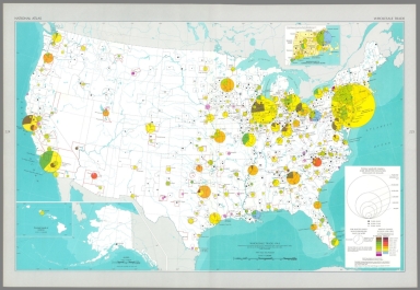
Selected population characteristics / compiled from U. S. Bureau of the Census, Census of population: 1960, v. 1, pt. A, Washington, U. S. Govt. Print Off., 1961 -- Population density : 1960.
List No
14359.180
Note
Chart and statistical map representing the United States, featuring the geographic density of population, including for major cities, as of 1960. Map also shows political boundaries, bodies of water, coastlines and islands. Includes a legend, as well as a bar scale and scale statement. Presented with Albers Equal Area Projection. With two inset maps: Principal islands of Hawaii -- Alaska. Chart shows populations for cities, including the change in population from 1950 to 1960. Colored lithograph. Map and chart are each 20 x 31 cm, on sheet 49 x 35 cm. Map and chart appear in Special subject maps section, subsection Socio-Cultural.
Author
[Geological Survey (U.S.), U.S. Census Bureau]
Full Title
American Indian population : 1960 / adapted from U. S. Bureau of the Census, American Indians in the United States: 1960, GE-50, no. 14, Washington, U. S. Govt. Print Off., 1967, map 1:5,000,000.
List No
14359.193
Note
Statistical map representing the United States, featuring the geographic density of the indigenous population, as of 1960. Map also shows political boundaries, bodies of water, drainage, coastlines and islands. Includes a legend, as well as a bar scale and scale statement. Presented with Albers Equal Area Projection. With two inset maps: Principal islands of Hawaii -- Alaska. Colored lithograph. Map is 43 x 66 cm, on double sheet 49 x 71 cm. Appears in Special subject maps section, subsection Socio-Cultural.
Author
[Geological Survey (U.S.), U.S. Census Bureau]
Full Title
Median family income : 1959 / compiled from U. S. Bureau of the Census, County and city data book: 1962, Washington, U. S. Govt. Print Off., 1962, table 2, item 22; Census of population: 1960, PC(S1)-48, Washington, U. S. Govt. Print Off., 1965, table 3.
List No
14359.196
Note
Statistical map representing the United States, featuring the geographic density of population according to the median family income in 1959. Map also shows political boundaries, bodies of water, drainage, coastlines and islands. Includes a legend, as well as a bar scale and scale statement. Presented with Albers Equal Area Projection. With two inset maps: Principal islands of Hawaii -- Alaska. Colored lithograph. Map is 43 x 66 cm, on double sheet 49 x 71 cm. Appears in Special subject maps section, subsection Socio-Cultural.
Author
[Geological Survey (U.S.), Hirt, Howard E., Cohen, Saul B., United States. Office of Education]
Full Title
Institutions of higher education / compiled by Howard E. Hirt, Bridgewater State College and Saul B. Cohen, Clark University, 1964, revised from U. S. Office of Education, Education directory, 1964-1965, Washington, U. S. Govt. Print Off., 1965, pt. 3, p. 211-218.
List No
14359.202
Note
Statistical map representing the United States, featuring the geographic locations of higher education institutions, as of 1965. Map also shows political boundaries, bodies of water, drainage, coastlines and islands. Includes a legend, as well as a bar scale and scale statement. Presented with Albers Equal Area Projection. With twenty-nine inset maps: 1. New York City area -- 1a. New York City -- 2. Pittsburgh -- 3. Baltimore -- 4. Washington -- 5. Trenton -- 6. Philadelphia -- 7. Nashville -- 8. Atlanta -- 9. New Orleans -- 10. Chicago -- 11. San Diego -- 12. Los Angeles -- 13. San Francisco - Oakland -- 14. Portland -- 15. Denver -- 16. Minneapolis - St. Paul -- 17. Milwaukee -- 18. Kansas City -- 19. St. Louis -- 20. Cincinnati -- 21. Cleveland -- 22. Massachusetts, Connecticut & Rhode Island -- 22a. Boston -- 22b. Providence -- 23. Detroit -- 24. Buffalo -- Principal islands of Hawaii -- Alaska. Colored lithograph. Map is 43 x 66 cm, on double sheet 49 x 71 cm. Accompanying descriptive text on pages 268 and 270. Appears in Special subject maps section, subsection Socio-Cultural.
Author
[Geological Survey (U.S.), U. S. Coast and Geodetic Survey]
Full Title
Horizontal control, status as of July 1, 1968 : [United States] / adapted from U. S. Coast and Geodetic Survey, Status of horizontal control, United States, July 1, 1968, Washington, 1968.
List No
14359.239
Note
Map representing the United States, featuring horizontal control surveys in mapping, as of 1968. Shows the geographic locations of different types of horizontal control, such as adjusted and unadjusted first and second-order. Also shows political boundaries, bodies of water, drainage, coastlines and islands. Includes latitudinal and longitudinal lines, and a legend, as well as a bar scale and scale statement. With two inset maps: Principal islands of Hawaii -- Alaska. Colored lithograph. Map is 43 x 66 cm, on double sheet 49 x 71 cm. Accompanied by descriptive text here, and on page 307. Appears in Special subject maps section, subsection Mapping and charting.
Author
Geological Survey (U.S.)
Full Title
World around the United States.
List No
14359.249
Note
World map featuring the position of the United States within the globe, as of 1970. Shows political boundaries, capital cities, bodies of water, coastlines and islands. Includes concentric circles around the United States indicating distance, as well as a scale statement and explanatory notes. Presented with Azimuthal Equidistant Projection. Colored lithograph. Map is 23 x 23 cm, on sheet 49 x 35 cm. Appears in Special subject maps section, subsection World.
Author
[Geological Survey (U.S.), U.S. Census Bureau, National Geographic Society (U.S.)]
Full Title
United States exports and imports of commodities : 1967 / compiled by U. S. Bureau of the Census: U. S. exports, 1967, FT 455, annual, table 3; U. S. general imports, 1967, FT 455, annual, table 3, Washington, U. S. Govt. Print. Off., 1968. Base map by National Geographic Society, The world, 1:63,360,000; rev. by U. S. Geol. Survey, 1968.
List No
14359.251
Note
World map featuring United States exports and imports of commodities in 1967. Shows streams of commerce between the United States and other nations, national borders, bodies of water, drainage, glaciers, coastlines and islands. Includes latitudinal and longitudinal lines, as well as a legend, bar scale, scale statement and explanatory notes. With three inset charts: Total exports, by commodity group -- Total imports, by commodity group -- Exports and imports by commodity group. Presented with Van der Grinten Projection. Colored lithograph. Map is 42 x 65 cm, on double sheet 49 x 71 cm. Appears in Special subject maps section, subsection World.
Author
[Geological Survey (U.S.), Harrison, Richard Edes]
Full Title
Shaded relief / Richard Edes Harrison, 1969.
List No
14359.261
Note
An experimental printing of Richard Edes Harrison's hand drawn relief map of 1964. This became the base topography of sheets 56-57, Shaded Relief by Harrison dated 1969. Not part of the atlas but acquired with a set of individual maps some of which were sold as single sheets by the U.S. Geological Survey.
Author
Playfair, William, 1759-1823
Full Title
(Covers to) Playfair. Tableaux d'arithmétique linéaire.
List No
14319.001
Note
Covers to Tableaux d'arithmétique linéaire. Title translates to: Linear arithmetic tables. Bound in board decorated with marbled paper. Leather spine and corners. Gilded spine title and floral decorations.
|


![Early Indian tribes, culture areas, and linguistic stocks : [Alaska].](https://www.davidrumsey.com/rumsey/Size2/RUMSEY~8~1/199/14359095.jpg)


![Horizontal control, status as of July 1, 1968 : [United States].](https://www.davidrumsey.com/rumsey/Size2/RUMSEY~8~1/199/14359239.jpg)


