|
Author
Marmocchi, Francesco C.
Full Title
(Title and Index Page to) Il Globo Atlante di Carte Geografiche Compilate da P.C. Marmocchi per servire di corredo al suo Corso di Geografia Commerciale. Genova, Paolo Rivara fu Giacomo Editore 1858. Torino, Lit. Giordana e Sabussolia.
List No
12235.002
Author
Marmocchi, Francesco C.
Full Title
2. Mappamondo Carte d'Insieme. 1855. Distribuzione delle Colonie Europee nelle diverse parti del mondo.
List No
12235.003
Author
Marmocchi, Francesco C.
Full Title
22. Nuovo Mondo Parte Settentriole Mappa d'Insieme.
List No
12235.023
Author
Marmocchi, Francesco C.
Full Title
29. Confederazione Messicana.
List No
12235.030
Author
Marmocchi, Francesco C.
Full Title
30. Stati Orientali della Unione Americana.
List No
12235.031
Author
Marmocchi, Francesco C.
Full Title
31. Stati e Territorii Occidentali della Unione Americana.
List No
12235.032
Author
[Berghaus, Heinrich, Berghaus, Hermann]
Full Title
(Title Page to) Berghaus' Physikalischer Atlas. (Begrundet 1836 durch Heinrich Berghaus). Dritte Ausgabe. 75 Karten in sieben Abteilungen enthaltend 514 Darstellungen uber Geologie, Hydrographie, Meteorologie, Erdmagnetismus, Pflanzenverbreitung, Tierverbreitung und Volkerkunde. Vollstandig neu bearbeitet und unter Mitwirkung von Dr. Oscar Drude ... Dr. Georg Gerland ... Dr. Julius Hann ... Dr. William Marshall ... Dr. Georg Neumayer ... Dr. Karl v. Zittel ... herausgegeben von Prof. Dr. Herm. Berghaus. Gotha: Justus Perthes. 1892.
List No
4391.002
Note
New edition of Berghaus' Atlas in seven parts : I: Geologie, II: Hydrographie, III: Meteorologie, IV: Erdmagnetismus, V: Pflanzenverbreitung, VI: Tierverbreitung, VII: Volkerkunde, with individual title pages dated variously 1887, 1891, and 1892, indicating that each was also published separately (see our copy of Atlas der Geologie). This is a new edition, updated by Berghaus' son, with all the maps completely redone, and still, amazingly, hand colored in a style equal to the first edition. There are actually only 74 maps, No. 7/8 are combined in one plate. Atlas is bound in half leather black cloth covered boards with "Berghaus' Physikal. Atlas." stamped in gilt on the front cover and spine.
Author
[Berghaus, Heinrich, Berghaus, Hermann, Luddecke, R., Hess, O.]
Full Title
Hohen und Tiefen. Entworfen u. bearbeitet v. Dr. R. Luddecke. Gest v. O. Hess. Ausgabe 1891. Gotha: Justus Perthes. (On upper margin) I. Abt. Geologie No. I. Berghaus' physikal atlas No.1. (to Accompany) Berghaus' Physikalischer Atlas. (Begrundet 1836 durch Heinrich Berghaus) ... Gotha: Justus Perthes. 1892. (insets) Erdprofile, im gleichen Langen- und Hohenmaassstab (aus Ferdinand Lingg's Erdprofil). (with) Grosste u. mittlere Hohen und Tiefen der westlichen Erdhalfte. (with) Grosste u. mittlere Hohen und Tiefen der ostlichen Erdhalfte.
List No
4391.012
Note
Color lithograph double hemisphere map, with inset maps and charts. Includes Comparative View of the Heights of the Principal Mountains in the World. Relief shown by contours. Depth shown by gradient tints.
Author
[Berghaus, Heinrich, Berghaus, Hermann, Schmidt, C., Risch, M.]
Full Title
Tieflander. Entw. v. Herm. Berghaus 1883, Ausg. 1887. Gez. v. C. Schmidt u. M. Risch. Gotha: Justus Perthes. (On upper margin) I. Abt. Geologie No. II. Berghaus' physikal atlas No. 2. (to Accompany) Berghaus' Physikalischer Atlas. (Begrundet 1836 durch Heinrich Berghaus) ... Gotha: Justus Perthes. 1892.
List No
4391.013
Note
14 color lithograph maps with insets on 1 sheet. Includes: Die Heutigen Niederlande, with insets: Niederlande in 1. Jahrhundert -- Niederlande in X. Jahrhundert, at scale of 1: 6,000,000. Fen District -- El-Ghor oder das Jordan Thal -- Kaspisches Tiefland und Manytsch Niederrung -- Natron-Seen -- El Fajum -- Nordrand der Libyschen Wuste -- Das Todte Thal -- Colorado-Wuste -- Nordrand der Algerischen Sahara -- Goban n. Paulistischke -- Sud-Australische Seen -- Tiefland Asale -- Assal-See. Relief shown by contours and spot heights. Depth shown by gradient tints and soundings. Prime meridian is Greenwich.
Author
[Berghaus, Heinrich, Berghaus, Hermann, Schmidt, C., Risch, M.]
Full Title
Thatigkeit des Erdinnern. Vulkane und Strand-veranderungen in Mollweide's flachenrechter Erdansicht. Entw. v. Herm. Berghaus 1885, Ausg. 1888. Gotha: Justus Perthes. (On upper margin) I. Abt. Geologie No. III. Berghaus' physikal atlas No. 3. (to Accompany) Berghaus' Physikalischer Atlas. (Begrundet 1836 durch Heinrich Berghaus) ... Gotha: Justus Perthes. 1892. (8 insets).
List No
4391.014
Note
Color lithograph maps with 8 insets and 1 profile view. Relief shown by contours and spot heights. Depth shown by gradient tints and soundings. Prime meridian is Greenwich. Insets: Jan Mayer, nordlichster Vulkan -- Erdbeben-Gebiete westliche -- Ostliche Erdbeben-Gebiete -- Insel Augustin (Tschernabura) -- Stromboli (Liparische Inseln) thatigster Vulkan -- Santorin (Kykladen) -- Sunda Strasse -- Tengger-Gebirge & Semiru. Includes legend and explanation.
Author
[Berghaus, Heinrich, Berghaus, Hermann, Rohrbach, C., Luddecke, R.]
Full Title
Grund und Boden. Bearbeitet v. Dr. C. Rohrbach, Red. v. Dr. R. Luddecke. Ausgabe 1892. Gotha: Justus Perthes. (On upper margin) I. Abt. Geologie No. IV. Berghaus' physikal atlas No. 4. (to Accompany) Berghaus' Physikalischer Atlas. (Begrundet 1836 durch Heinrich Berghaus) ... Gotha: Justus Perthes. 1892. (7 insets).
List No
4391.015
Note
Color lithograph double hemisphere map with 7 insets. Depth shown by gradient tints and soundings. Insets: Dunen des Nefud -- Sudliche Erdhalfte, Niederschlage im Juli -- Niederschlage im Januar, Nordliche Erdhalfte -- Dunen in Central Australien -- Dunen des Tharr -- Ostliche Areg -- Trockene Niederschlage. Includes legend and explanation.
Author
[Berghaus, Heinrich, Berghaus, Hermann]
Full Title
Eisverbreitung, einst und jetzt. Polar Ansicht der Erde in Lambert's flachenrechter Azimuthal-projection. Entw. v. Herm. Berghaus 1884, Ausg. 1886. Gotha: Justus Perthes. (On upper margin) I. Abt. Geologie No. V. Berghaus' physikal atlas No. 5. (to Accompany) Berghaus' Physikalischer Atlas. (Begrundet 1836 durch Heinrich Berghaus) ... Gotha: Justus Perthes. 1892. (7 insets).
List No
4391.016
Note
Color lithograph double hemisphere map with 7 insets. Depth shown by gradient tints, isoline and soundings. Relief shown by hachures. Insets: Der Rhein-Gletscher nach A. Favre -- Der Rhone Gletscher nach A. Falsan -- Seen-Gebiet in Nord-Amerika nach Chamberlin und Wright -- Die Europaischen Alpen -- Iseo-Gletscher nach Stroppani -- Der Loisach- und Inn-Gletscher n. Penck & Bayberger -- Die Sudlichen Alpen (Neu-Seeland) nach J. v. Haast. Includes legend and explanation.
Author
[Berghaus, Heinrich, Berghaus, Hermann, Risch, M., Hess, O., Kogel, F.]
Full Title
Gletscherkarte. Entw. v. Herm. Berghaus 1885, Ausg. 1888. Gez. v. M. Risch. Gest. v. O. Hess, Berge v. F. Kogel. Gotha: Justus Perthes. (On upper margin) I. Abt. Geologie No. VI. Berghaus' physikal atlas No. 6. (to Accompany) Berghaus' Physikalischer Atlas. (Begrundet 1836 durch Heinrich Berghaus) ... Gotha: Justus Perthes. 1892.
List No
4391.017
Note
21 color lithograph maps on 1 sheet. Relief shown by hachures and spot heights. Insets: Inlandeis des Frederickshaab-Glets chers nach J.A.D. Jensen -- Gronlandisches Binnen-Eis -- Justedals Bra -- Jotun Fjeld -- Berner Oberland -- Gletscher des Halbinsel Kenai (Alaska) -- Aus dem sudlichen Gronland n. G. Holm -- Gletscher des Mount Tacoma (nach dem Northern Transcontinental Survey) von Bailey Willis -- Gletscher des Mount Shasta (nach dem U.S. Geological Survey) von J.S. Diller -- Gletscher von Oisans -- Nevado de Chillan nach A. Philippi -- San Rafael Gletscher -- Oetzthaler Gruppe -- Glockner Gruppe -- Ross-Gletscher (Sud-Georgien) -- Gletscher des Adai Choch (Kaukasus) nach M. v. Dechy -- Hohe von Schneegrenzen und Gletscher-Enden -- Gletscher des Kasbek -- Serafschan Gletscher (Turkestan) nach I.W. Muschketow -- Neuseelandische Alpen nach R. v. Lendenfield.
Author
Burr, David H., 1803-1875
Full Title
(Title Page) An Atlas Of The State of New York, Containing A Map of the State And Of The Several Counties ... under the superintendance & direction of Simeon DeWitt, Surveyor General, pursuant to an Act of the Legislature, And also the Physical Geography of the State & of the several Counties & Statistical Tables of the Same, By David H. Burr. New York, Published by David H. Burr. 1829. RePublished At Ithaca, N.Y. By Stone And Clark With Corrections And Improvements. 1840. Engravd. by Rawdon, Clark & Co. Albany & Rawdon, Wright & Co., New York.
List No
0105.002
Note
Includes vignette of "View on the Hudson River near Fishkill".
Author
Burr, David H., 1803-1875
Full Title
Map of the State of New-York and the Surrounding Country.
List No
0105.025
Author
Burr, David H., 1803-1875
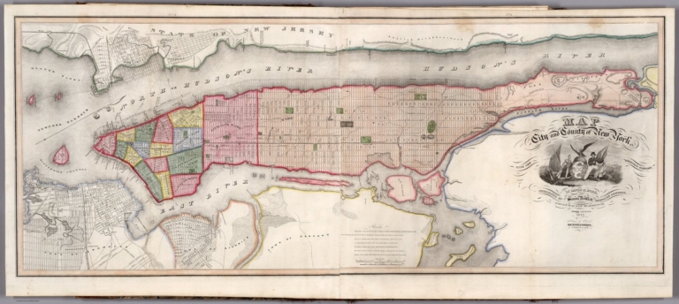
Full Title
Map of the City and County of New York.
List No
0105.026
Note
Foldout. Third edition.
Author
Burr, David H., 1803-1875
Full Title
Map of the Counties of New York, Queens, Kings, and Richmond.
List No
0105.028
Author
Finley, Anthony
Full Title
(Title Page to) A New General Atlas Comprising a Complete Set of Maps, representing the Grand Divisions Of The Globe, Together with the several Empires, Kingdoms, and States in the World; Compiled from the Best Authorities, and corrected by the Most Recent Discoveries. Philadelphia: Published by Anthony Finley. 1827. (title page only) Written And Engraved By Jos. Perkins.
List No
0282.002
Note
This 1827 of the New general atlas was issued with substantial county changes in the developing states since the second 1824 issue. The atlas was first issued in 1824, with editions published annually to 1834. Each succeeding year new maps were added and others updated. This atlas bound in half leather marbled paper covered boards covers with a green label printed with "A New General Atlas, Containing Sixty Maps. Philadelphia: Published By Anthony Finley." and "Finley General Atlas" stamped in gold on the spine. Engraved title page "written and engraved by Jos. Perkins", index and statistical table; 58 hand colored maps engraved by Young & Delleker and 2 engraved hand colored tables.
Author
Finley, Anthony
Full Title
North America. Young & Delleker Sc. Published by A. Finley, Philada. (to accompany) A New General Atlas Comprising a Complete Set of Maps, representing the Grand Divisions Of The Globe ... Philadelphia: Published by Anthony Finley. 1827.
List No
0282.008
Note
Full color map by country on sheet 35x27. Relief shown pictorially. Prime meridian is Greenwich. Shows major cities, capitals, rivers and ports.
Author
Finley, Anthony
Full Title
Indiana. Young & Delleker Sc. Published by A. Finley, Philada. (to accompany) A New General Atlas Comprising a Complete Set of Maps, representing the Grand Divisions Of The Globe ... Philadelphia: Published by Anthony Finley. 1827.
List No
0282.030
Note
Full color map on sheet 35x27. Relief shown pictorially. Prime meridians are Washington and Greenwich. Shows counties, major cities, roads and rivers.
Author
Finley, Anthony
Full Title
Mexico. Young & Delleker Sc. Published by A. Finley, Philada. (to accompany) A New General Atlas Comprising a Complete Set of Maps, representing the Grand Divisions Of The Globe ... Philadelphia: Published by Anthony Finley. 1827.
List No
0282.035
Note
Full color map on sheet 35x27. Relief shown pictorially. Prime meridians are Washington and Greenwich. Covers California, Texas and New Mexico. Shows political boundaries, administrative divisions, major cities, Indian settlements and rivers.
Author
[Munster, Sebastian, 1488-1552, Ptolemy, Claudius, Pirckheimer, Willibald, 1470-1530]
Full Title
(Title Page to) Geographia universalis, vetus et nova, complectens Claudii Ptolemaei Alexandrini enarrationis libros VIII : quorum primus nova translatione Pirckheimheri et accessione commentarioli illustrior quam hactenus fuerit redditus est ... Succedunt tabulae ptolemaicae, opera Sebastiani Munsteri novo paratae modo ... Basileae apud Henricum Petrum Mense Martio anno M.D. XL (1540).
List No
11623.002
Note
First edition of Sebastian Munster’s Geographia Universalis, published in 1540. A new and important edition of Ptolemy, with redesigned maps and the text revised by Sebastian Munster, based on the Willibald Pirckheimer Latin translation, with corrections of 1535 by Servetus. A reprint was made in 1542 and two re-editions, adding maps, in 1545 and 1552. The atlas consists of Letterpress title, Liber I-VIII, plus text printed in two columns, including 7 woodcut diagrams in the text, tables, errata, index and one full-page printer’s woodcut device on verso of colophon leaf. Also includes 48 double-page woodcut maps, 27 maps of the ancient world, 21 of the modern world, each within a woodcut border, and with descriptive text on reverse of each map, printed within ornamental woodcut borders, designed in the Holbein style. Includes the first separate maps of the four continents, and the earliest maps of Western Hemisphere and Africa, also the first separately printed map of England, and the oldest obtainable woodcut of Scandinavia. The map Novarum insularum is one of the earliest available separate maps depicting the Americas in a recognizable form. Maps are uncolored, showing settlements, landmarks, roads, rivers and mountains. Bound in reddish brown full calf embossed binding, with title "Ptolemaei Geographia Universalis" stamped on spine. Sebastian Munster,1448-1552, was a mathematician, geographer and professor at Basel University. He also compiled a highly influential encyclopedic work entitled Cosmographia Universalis, which first appeared in 1544 and contained forty-eight woodcut maps. He was among the first editors of a published geographical text to quote or acknowledge his sources and authorities.
Author
[Munster, Sebastian, 1488-1552, Ptolemy, Claudius, Pirckheimer, Willibald, 1470-1530]
Full Title
(Text Page to) Orbis Universalis descriptio. (to accompany) Geographia universalis, vetus et nova, complectens Claudii Ptolemaei Alexandrini enarrationis libros VIII ... Basileae apud Henricum Petrum Mense Martio anno M.D. XL (1540).
List No
11623.008
Note
Descriptive text to map of world, printed within ornamental woodcut borders.
Author
[Munster, Sebastian, 1488-1552, Ptolemy, Claudius, Pirckheimer, Willibald, 1470-1530]
Full Title
Typus Orbis Universalis. (to accompany) Geographia universalis, vetus et nova, complectens Claudii Ptolemaei Alexandrini enarrationis libros VIII ... Basileae apud Henricum Petrum Mense Martio anno M.D. XL (1540).
List No
11623.009
Note
Woodcut uncolored map of the world. The first map to name the pacific Ocean “Mare Pacificum”. Shows windheads around the map sea monsters, rivers and mountains. Relief shown pictorially.
Author
[Munster, Sebastian, 1488-1552, Ptolemy, Claudius, Pirckheimer, Willibald, 1470-1530]
Full Title
(Text Page to) Descriptio Orbis generalis ... (to accompany) Geographia universalis, vetus et nova, complectens Claudii Ptolemaei Alexandrini enarrationis libros VIII ... Basileae apud Henricum Petrum Mense Martio anno M.D. XL (1540).
List No
11623.010
Note
Descriptive text to the general map of world, printed within ornamental woodcut borders.
Author
[Munster, Sebastian, 1488-1552, Ptolemy, Claudius, Pirckheimer, Willibald, 1470-1530]
Full Title
Typus orbis a Ptol. descriptus. (to accompany) Geographia universalis, vetus et nova, complectens Claudii Ptolemaei Alexandrini enarrationis libros VIII ... Basileae apud Henricum Petrum Mense Martio anno M.D. XL (1540).
List No
11623.011
Note
Woodcut uncolored map of the modern world and its regions. Shows windheads around the map, rivers and mountains. Relief shown pictorially. Includes notes.
Author
[Munster, Sebastian, 1488-1552, Ptolemy, Claudius, Pirckheimer, Willibald, 1470-1530]
Full Title
(Text Page to) Novarum Inuvlarum descriptio ... (to accompany) Geographia universalis, vetus et nozva, complectens Claudii Ptolemaei Alexandrini enarrationis libros VIII ... Basileae apud Henricum Petrum Mense Martio anno M.D. XL (1540).
List No
11623.099
Note
Descriptive text to the modern map of Holy Land, printed within ornamental woodcut borders.
Author
[Munster, Sebastian, 1488-1552, Ptolemy, Claudius, Pirckheimer, Willibald, 1470-1530]
Full Title
Novae Insulae XVII Nova Tabula. (to accompany) Geographia universalis, vetus et nozva, complectens Claudii Ptolemaei Alexandrini enarrationis libros VIII ... Basileae apud Henricum Petrum Mense Martio anno M.D. XL (1540).
List No
11623.100
Note
Woodcut uncolored map of the New World, the first edition of map of the continent of America, and the earliest map to show all of North and South America in a continental form. It is the first to name the Pacific Ocean (Mare Pacificum) and the Straits of Magellan, with his ship Victoria in the Pacific. Shows The flags of Spain (on Puerto Rico), place names, rivers and mountains. Relief shown pictorially. Included notes.
Author
Chen, Haoji
Full Title
(Title Page to) Zhongguo xin yu tu = New atlas of China. Chen Haoji zhu. Shang wu yin shu guan. Commercial Press Ltd., Shanghai. Minguo 6. (1917).
List No
9819.002
Note
26 double-page full color maps, 6 pages of text, in Chinese. 3rd. edition, (Minguo 6) 1917, first published in 1913. (Minguo 2). Detailed atlas of China, title and imprint in Chinese and English. Bound in brown cloth covered boards with embossed red lettering and decoration. Showing detail map of all the provinces, with insets for important cities. Each map shows local topography, roads, railroads, the Great Wall, cities and towns, etc. The Commercial Press was founded in Shanghai in 1897 and was the first modern publishing firm in the country. Small booksellers stamp pastedown in Russian inside front cover.
Author
Chen, Haoji
Full Title
(Physical map of China). (to accompany) New atlas of China = Zhongguo xin yu tu. Chen Haoji zhu. Shang wu yin shu guan. Commercial Press Ltd., Shanghai. Minguo 6. (1917).
List No
9819.006
Note
Color map, No.1. Showing physical feature of China, terrain. Mountains, hills, and highlands, Plateau of Tibet, etc. Relief shown by gradient tints and contours. Depth shown by gradient tints.
Author
Chen, Haoji
Full Title
(Political map of China). (to accompany) New atlas of China = Zhongguo xin yu tu. Chen Haoji zhu. Shang wu yin shu guan. Commercial Press Ltd., Shanghai. Minguo 6. (1917).
List No
9819.007
Note
Outline color map, No.2. Showing Self-governed Municipalities, Autonomous Regions, Provinces and Special Administrative Regions. Relief shown by hachures.
Author
[Briet, Philip, 1601-1668, Cramoisy, Sebastiani, Cramoisy, Gabrielis]
Full Title
(Title Page) (Volume 1) Parallela Geographiae Veteris et Novae. Auctore Philippo Brietio, Abbasillaeo, Societatis Jesu Sacerdote. Parisiis, Sumptibus: Sebastiani Cramoisy, Regis & Reginae Regentis Architypographi: et Gabrielis Cramoisy. Via Jacobzea, sula Ciconiis. M. DC. XLVIII. Cum Privilegio Regis.
List No
12063.002
Author
[Briet, Philip, 1601-1668, Cramoisy, Sebastiani, Cramoisy, Gabrielis]
Full Title
(Title Page - Decorative) (Volume 1) Parallela Geographiae Veteris et Novae. Auctore Philippo Brietio, Abbasillaeo, Societatis Jesu Sacerdote. Parisiis. 1648.
List No
12063.003
Author
[Briet, Philip, 1601-1668, Cramoisy, Sebastiani, Cramoisy, Gabrielis]
Full Title
(Diagram) Sphaera Armillaris.
List No
12063.010
Author
[Briet, Philip, 1601-1668, Cramoisy, Sebastiani, Cramoisy, Gabrielis]
Full Title
(Diagram) Habitationes.
List No
12063.011
Author
[Bachelder, John Badger, 1825-1894, Warren, G.K., Humphreys, A. A.]
Full Title
Map of the battle field of Gettysburg, July 1st, 2nd, 3rd 1863. First day battle. Published by authority of the Hon. the Secretary of War, Office of the Chief of Engineers U.S. Army. 1876. Positions of troops compiled and added for the government by John B. Bachelder. Topography engraved by Julius Bien, 16 Park Place N. Y. Position & lettering by Louis E. Newman, 36 Vesey St., N.Y. Printed by Endicott & Co., New York.
List No
11605.001
Note
First map of the battle field of Gettysburg, July 1st, 1863. Relief shown by contours, form lines and spot heights. Scale:1:12,000. 1 in. represents 1000 ft. Shows Gettysburg environs, place names, the position of the troops by color and signal stations Includes notes. "The survey was ordered by Brevet Major General A.A. Humphreys, Chief of Engineers, and conducted under Brevet Major General G.K. Warren, Major of Engineers."
Author
[Bachelder, John Badger, 1825-1894, Warren, G.K., Humphreys, A. A.]
Full Title
Map of the battle field of Gettysburg, July 1st, 2nd, 3rd 1863. First day battle. Published by authority of the Hon. the Secretary of War, Office of the Chief of Engineers U.S. Army. 1876. Positions of troops compiled and added for the government by John B. Bachelder. Topography engraved by Julius Bien, 16 Park Place N. Y. Position & lettering by Louis E. Newman, 36 Vesey St., N.Y. Printed by Endicott & Co., New York.
List No
11605.002
Note
Second map of the battle field of Gettysburg, July 2nd, 1963. Relief shown by contours, form lines and spot heights. Scale:1:12,000. 1 in. represents 1000 ft. Shows Gettysburg environs, place names, the position of the troops by color and signal stations Includes notes. "The survey was ordered by Brevet Major General A.A. Humphreys, Chief of Engineers, and conducted under Brevet Major General G.K. Warren, Major of Engineers."
Author
[Bachelder, John Badger, 1825-1894, Warren, G.K., Humphreys, A. A.]
Full Title
Map of the battle field of Gettysburg, July 1st, 2nd, 3rd 1863. First day battle. Published by authority of the Hon. the Secretary of War, Office of the Chief of Engineers U.S. Army. 1876. Positions of troops compiled and added for the government by John B. Bachelder. Topography engraved by Julius Bien, 16 Park Place N. Y. Position & lettering by Louis E. Newman, 36 Vesey St., N.Y. Printed by Endicott & Co., New York.
List No
11605.003
Note
Third map of the battle field of Gettysburg, July 3rd, 1963. Relief shown by contours, form lines and spot heights. Scale:1:12,000. 1 in. represents 1000 ft. Shows Gettysburg environs, place names, the posi+tion of the troops by color and signal stations Includes notes. "The survey was ordered by Brevet Major General A.A. Humphreys, Chief of Engineers, and conducted under Brevet Major General G.K. Warren, Major of Engineers."
Author
[Wytfliet, Corneille, Magini, Giovanni Antonio]
Full Title
(Title Page to) Histoire universelle des Indes occidentales et orientales, et de la conversion des Indiens : divisee en trois parties par Cornille Wytfliet & Anthoine Magin & autres historiens. Premiere Partie. A Douay, Chez Francois Fabri, l'An 1611.
List No
11622.005
Note
Wyfliet's atlas is the first atlas devoted entirely to maps of the Americas, (the New world), was first published in Latin as Descriptionis Ptolemaicae augmentum in 1597, and later published in Latin editions in 1598 and 1603. Then translated into French and combined with the work of Magini’s description of the West and East Indies and Japan, published under the present title in 1605 and further editions published in 1607 and 1611. This is 3rd edition of “Histoire Universelle des Indes occidentales et orientales ...” in French: by Cornille Wytfliet & Anthoine Magin & other historians, divided into 2 books and in three parts, published at Douay, at Francois Fabri, in 1611. Part 1: Histoire universelle des Indes occidentales: Universal History of the West Indies. Part 2: Histoire universelle des Indes orientales : Universal History of the East Indies. Part 3: La suite de l'Histoire des Indes orientales, de la conversion des Indies: The continuation of the history of the East Indies, the conversion of the Indians, each part with engraved decorative title page. Atlas includes indexes, tables and 23 double-page engraved maps. All maps dated 1597, except Canada, 1607; Virginia, 1611; and Limes occidentale, 1607. The first map (a double-hemisphere world map) is based on Mercator's influential map of 1587. Then follows maps of South America (the north coast of South America with the Caribbean islands, Hispaniola, Cuba and Jamaica, Chile, Peru, Brazil, , Colombia, Central America, and maps of North America. In addition to the large double-page maps there are also four small maps on one double-page sheet in Magini's supplement showing the East Indies, Japan, China and the Philippines. Bound in full calf, spine gilt with title “Histoire des Indes” in gilt on spine.
Author
[Wytfliet, Corneille, Magini, Giovanni Antonio]
Full Title
Utriusque Hemispherii Delineatio. (to accompany) Histoire universelle des Indes occidentales et orientales, et de la conversion des Indiens : divisee en trois parties par Cornille Wytfliet & Anthoine Magin & autres historiens. Premiere Partie. A Douay, Chez Francois Fabri, l'An 1611.
List No
11622.009
Note
Double page uncolored engraved double hemisphere map of the world, supported by vignette of Atlas from below, with title cartouche. Showing Terra Australis fills the Southern Hemisphere, Quivira and Anian are named on the West Coast of North America. Florida and Norimbega are shown on the Eastern Coast of North America. Includes rivers and mountains. Relief shown pictorially.
Author
[Wytfliet, Corneille, Magini, Giovanni Antonio]
Full Title
Chica sive Patagonica et Australis Terra. (to accompany) Histoire universelle des Indes occidentales et orientales, et de la conversion des Indiens : divisee en trois parties par Cornille Wytfliet & Anthoine Magin & autres historiens. Premiere Partie. A Douay, Chez Francois Fabri, l'An 1611.
List No
11622.013
Note
Uncolored engraved double page map divided in two sections. Shows Strait of Magellan or Patagonia and at the bottom shows a polar view of the Terra Australis with Southern Africa and Madagascar. Relief shown pictorially. Includes decorative title cartouche.
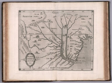
Author
[Wytfliet, Corneille, Magini, Giovanni Antonio]
Full Title
Plata Americae provincia. (to accompany) Histoire universelle des Indes occidentales et orientales, et de la conversion des Indiens : divisee en trois parties par Cornille Wytfliet & Anthoine Magin & autres historiens. Premiere Partie. A Douay, Chez Francois Fabri, l'An 1611.
List No
11622.020
Note
Uncolored engraved double page map of the Rio de la Plata region. Covers Argentina, Uruguay and the southern part of Brazil. Shows cities, towns, landmarks, rivers, capes, bays and mountains. Relief shown pictorially. Includes decorative title cartouche.
Author
[Wytfliet, Corneille, Magini, Giovanni Antonio]
Full Title
Granata Nova et California. (to accompany) Histoire universelle des Indes occidentales et orientales, et de la conversion des Indiens : divisee en trois parties par Cornille Wytfliet & Anthoine Magin & autres historiens. Premiere Partie. A Douay, Chez Francois Fabri, l'An 1611.
List No
11622.048
Note
Uncolored engraved double page map of California, Baja California the Southwestern U.S. Includes decorative title cartouche. Shows the coast of California, cities, towns, landmarks, rivers and mountains. Relief shown pictorially.
Author
[Wytfliet, Corneille, Magini, Giovanni Antonio]
Full Title
Florida et Apalche. (to accompany) Histoire universelle des Indes occidentales et orientales, et de la conversion des Indiens : divisee en trois parties par Cornille Wytfliet & Anthoine Magin & autres historiens. Premiere Partie. A Douay, Chez Francois Fabri, l'An 1611.
List No
11622.055
Note
Uncolored engraved double page map of Florida and the Southeast Coast of North America, part of Cuba and Bahamas. Shows cities, towns, landmarks, rivers, forests and mountains. Relief shown pictorially. Includes decorative title cartouche.
Author
[Wytfliet, Corneille, Magini, Giovanni Antonio]
Full Title
Norumbega et Virginia. (to accompany) Histoire universelle des Indes occidentales et orientales, et de la conversion des Indiens : divisee en trois parties par Cornille Wytfliet & Anthoine Magin & autres historiens. Premiere Partie. A Douay, Chez Francois Fabri, l'An 1611.
List No
11622.058
Note
Uncolored engraved double page map ofthe eastern coastline of North America, from S. Pietro" south to "Buelta de Arenas. Shows cities, towns, landmarks, rivers, forests and mountains. Relief shown pictorially. Includes decorative title cartouche.
Author
[Wytfliet, Corneille, Magini, Giovanni Antonio]
Full Title
India Orientalis. Iapaniae regnum. Chinae regnum. Insulae Philippinae. (to accompany) Histoire universelle des Indes occidentales et orientales, et de la conversion des Indiens : divisee en trois parties par Cornille Wytfliet & Anthoine Magin & autres historiens. Premiere Partie. A Douay, Chez Francois Fabri, l'An 1611.
List No
11622.072
Note
4 maps on 1 double page sheet. Includes East Indies, Japan, China and Philippine Islands. maps showing cities, coastal towns, rivers and mountains. Relief shown pictorially.
Author
Shurtleff, Elizabeth
Full Title
Star Map. Face South, And Raise Map Over Head, To Place Constellations.Guide to Star Magnitudes.
List No
10097.000
Note
Date estimated. A pictorial celestial map. Instructions under the title explain how to hold the map to identify the constellations in the night sky. With strong colors in the style of other Shurtleff pictorial maps. Another edition was published by the Graphic History Association in the same year (Worldcat). A folded version was accompanied by an envelope.
Author
[Chirpe, W Rodney, Montgomery Ward Co., Inc.]
Full Title
Texas Centennial Exposition 1830-1936 : presented by Montgomery Ward. Designed by W. Rodney Chirpe. Copyright 1936 by Montgomery Ward Co., Inc.
List No
11641.000
Note
Color pictorial map of Texas, Includes historical vignettes on both sides and lower panels, historical notes and decorative compass rose oriented with the north to upper right margin. Shows landmarks, roads, farms, railroads, park, industry, agriculture, rivers, mountains and Native American settlements. Relief shown pictorially. Centennial Exposition was held at Fair Park in Dallas, to celebrate the 100th anniversary of Texas's independence from Mexico in 1836. It was also a celebration of Texas and Western culture. W. Rodney Chirpe was an artist who achieved some success in commercial and advertizing design. His work was featured in an exhibit at the Art Institute of Chicago in 1934.
Author
Nolin, Jean-Baptiste, 1648-1708
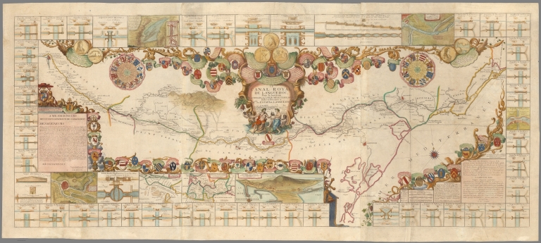
Full Title
Le canal royal de Languedoc, pour la ionction de l'ocean et de la mer Mediterranee : dedie et presente a Mgrs. des estats de Languedoc. A Paris : Chez I.B. Nolin geographe, graveur, et imprimeur de S.A.R. Monsieur, sur le quay de l'Horloge du Palais a l'Enseigne de la Place des Victoires vers le Pont-Neuf, en Ianvier 1697. Par leur tres humble, tres obeissant, et devoue serviteur I.B. Nolin Geographe ord. du Roy.
List No
11642.000
Note
Color map of the Royal Canal of Languedoc (Canal du Midi) by J.B. Nolin, which was built through southwestern France to connect the Mediterranean with the Atlantic. Extending for 150 miles, it ran from the port of Sete on the Mediterranean to Toulouse on the Garonne River. The project was approved by Royal Decree of Louis XIV in 1666 and took nearly 20 years to complete. It was the largest civil engineering project in seventeenth century Europe. The map is surrounded by coats of arms of the men associated with the construction of the canal and by 51 numbered views of aqueducts, locks and basins, and 3 inset maps with titles: Carte particuliere de l'entree de la Garonne; Carte de la communication de l'Ocean et de la Mediteranee par le canal royal de Languedoc and Carte de la riviere de Beziers, ou de l'Ore ... Includes text on the history of the project, dedication note, decorative title cartouche and compass rose. Relief shown pictorially.
Author
Sonnenstern, Maximilian von, 1819-1895
Full Title
Mapa de la Republica de la Nicaragua : levantado por orden de su Exa. el Presidente, Cap't General Martinez. por Maximiliano de Sonnenstern. (3 insets and cross-sections)
List No
11644.000
Note
The General Map of the Republic of Nicaragua. Published by Broise et Tiheffry, Paris. Map shows rivers, mines, ruins, international boundaries with Honduras and Costa Rica, departmental boundaries, roads, planned railways, Indian settlements, canals and the Atlantic and Pacific oceans. Relief shown by hachures and form lines. Includes legend, 3 inset maps and 13 cross sections, four cross sections showing the heights of mountains and volcanoes. Maximilian von Sonnenstern was a civil engineer of German origin who worked for many years for the government of Nicaragua and made detailed studies of the country. The General Map of the Republic of Nicaragua, created by order of the Nicaraguan government, is the first official map of that country on a systematic trigonometric survey, and it served as authoritative map of Nicaragua from 1863-1898. Sonnenstern published an earlier map of Nicaragua in 1859 at a smaller scale and size, and with much less detail overall.
|