
|
|
|
Pacific Coast subjects. United States. Census Office; Galpin, S. A. 1874
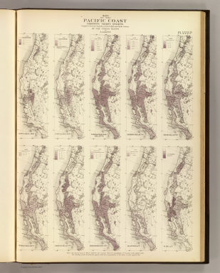 View larger, zoomable image (turn off pop-up blocker) Full Title: Maps of the Pacific Coast exhibiting various subjects. Compiled from the statistics of the eight and ninth census of the United States by S.A. Galpin. (Julius Bien, Lith., 1874) Author: United States. Census Office; Galpin, S. A. Date: 1874 This historical cartographic image is part of the David Rumsey Historical Map Collection, www.davidrumsey.com, a large collection of online antique, rare, old, and historical maps, atlases, globes, charts, and other cartographic items. Read more about the Collection. Or you can view the entire David Rumsey Map Collection in Insight. Full David Rumsey Map Collection Catalog Record: Author: United States. Census Office; Galpin, S. A. Date: 1874 Short Title: Pacific Coast subjects. Publisher: Washington: U.S. Type: Atlas Map Object Height cm: 53 Object Width cm: 39 Scale 1: 7,800,000 Note: Ten colored lithographed maps. Contents: Population--1850 -- Population--1860 -- Foreign-parentage relative -- Foreign--relative -- Irish--relative -- German--relative -- Chinese--relative -- Preponderating sex -- Illiteracy -- Wheat. State / Province: California ; Nevada ; Oregon ; Washington Subject: Statistical ; Agriculture Full Title: Maps of the Pacific Coast exhibiting various subjects. Compiled from the statistics of the eight and ninth census of the United States by S.A. Galpin. (Julius Bien, Lith., 1874) List No: 3566.036 Page No: XXXVIb Series No: 39 Engraver or Printer: Bien, Julius Published In: Statistical atlas of the United States based on the results of the ninth census 1870 with contributions from many eminent men of science and several departments of the government. Compiled under authority of Congress by Francis A. Walker, M.A., Superintendent of the 9th Census, professor of political economy and history, Sheffield Scientific School of Yale College. Julius Bien, Lith., 1874. Publication Author: United States. Census Office; Walker, Francis Amasa, 1840-1897 Publication Date: 1874 Publication Reference: Phillips, 1330; Phillips. Maps of America, p. 919; LeGear. Atlases of the United States, 407. Publication Note: See note field above. Publication List No: 3566.000 Publication Type: Statistical Atlas Publication Maps: 38 Publication Height cm: 56 Publication Width cm: 43 Image No: 3566036
Important!
The Insight® Browser and Java client software are products of Luna Imaging, Inc. If you have comments, suggestions, or need help, contact The David Rumsey Collection at home | about | view the
collection | recent
additions | news | help |
