
|
|
|
Westchester Co., Yonkers-state line. (Bien, Joseph Rudolf); (Vermeule, C. C. (Cornelius Clarkson), 1858-1950), 1893
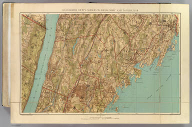 View larger, zoomable image (turn off pop-up blocker) Full Title: Westchester County, Yonkers to Dobbs Ferry, east to state line. Copyrighted by Julius Bien & Co., 1890. (1893) Author: (Bien, Joseph Rudolf); (Vermeule, C. C. (Cornelius Clarkson), 1858-1950) Date: 1893 This historical cartographic image is part of the David Rumsey Historical Map Collection, www.davidrumsey.com, a large collection of online antique, rare, old, and historical maps, atlases, globes, charts, and other cartographic items. Read more about the Collection. Or you can view the entire David Rumsey Map Collection in Insight. Full David Rumsey Map Collection Catalog Record: Author: (Bien, Joseph Rudolf); (Vermeule, C. C. (Cornelius Clarkson), 1858-1950) Date: 1893 Short Title: Westchester Co., Yonkers-state line. Publisher: New York: Julius Bien Type: Atlas Map Object Height cm: 55 Object Width cm: 81 Scale 1: 31,680 Note: Col. lithograph. Relief shown by contours, shading and spot heights; depths by soundings and isolines. Topographic map showing streets, neighborhoods, railroads, ferries, woods, marshes, etc. Unlike issue in 1891 Atlas of the Metropolitan District ..., this lacks plate number and has in lower left margin: From Atlas of the Metropolitan District published by Julius Bien & Company. State / Province: New York ; New Jersey County: Westchester County (N.Y.) ; Bergen County (N.J.) City: Yonkers (N.Y.) Full Title: Westchester County, Yonkers to Dobbs Ferry, east to state line. Copyrighted by Julius Bien & Co., 1890. (1893) List No: 0070.035 Page No: (32) Series No: 38 Published In: Atlas of Westchester County, New York. Prepared under the direction of Joseph R. Bien, E.M., civil and topographical engineer from original surveys and official records. Published by Julius Bien & Company, New York, 1893. Copyright by Julius Bien & Company - 1893. Publication Author: Bien, Joseph Rudolf Publication Date: 1893 Publication Reference: Phillips, 2262; Phillips. Maps of America, p. 1052 and 1065; LeGear. Atlases of the United States, L2506. Publication Note: See note field above. Publication List No: 0070.000 Publication Type: County Atlas Publication Maps: 32 Publication Height cm: 53 Publication Width cm: 42 Image No: 0070035
Important!
The Insight® Browser and Java client software are products of Luna Imaging, Inc. If you have comments, suggestions, or need help, contact The David Rumsey Collection at home | about | view the
collection | recent
additions | news | help |
