
|
|
|
Orange Co., Va., Mine Run, Rapidan River. Hoffman, J. Paul; Confederate States of America. Army of Northern Virginia.; United States. War Department, 1895
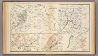 View larger, zoomable image (turn off pop-up blocker) Full Title: Map of Orange County &c., Va. embracing the details and plan of operations of Confederate and Federal forces at Mine Run and Rapidan River by order of ... W.P. Smith, Lt., Col. of Engrs., Topl. Office, A.N.V. Prepared by J. Paul Hoffman. Accompanying report of General R.E. Lee, C.S. Army. (with) Part of map of portions of the military departments of Washington, Pennsylvania, Annapolis and Northeastern Virginia. Compiled in the Bureau of Topographical Engrs., War Department &c., 1861. Accompanying report of Capt. L.B. Norton ... (with Decatur, Howard's Plantation). From original in possession of Gen. W.T. Sherman. (with Brownings C.H.-Stone Mountain) C.B. Reese, Capt. Engrs. From original in possession of Gen W.T. Sherman. (with Campbellton Region) Accompanying letter of Maj. Gen. George Stoneman. (with) Map to show lines of march of Second Army Corps and the enemy, Oct. 14, 1863 ... report of ... G.K. Warren. (with) Map of battle-field at Bristoe fought by 2d Army Corps commanded by Maj. Gen. G.K. Warren, October 14, 1863. (with) Map of Missionary Ridge, Tenn. showing the positions attacked by the forces under the command of Maj. Gen. W.T. Sherman, Nov. 24th and 25th, 1863. Julius Bien & Co., Lith., N.Y. (1891-1895) Author: Hoffman, J. Paul; Confederate States of America. Army of Northern Virginia.; United States. War Department Date: 1895 This historical cartographic image is part of the David Rumsey Historical Map Collection, www.davidrumsey.com, a large collection of online antique, rare, old, and historical maps, atlases, globes, charts, and other cartographic items. Read more about the Collection. Or you can view the entire David Rumsey Map Collection in Insight. Full David Rumsey Map Collection Catalog Record: Author: Hoffman, J. Paul; Confederate States of America. Army of Northern Virginia.; United States. War Department Date: 1895 Short Title: Orange Co., Va., Mine Run, Rapidan River. Publisher: Washington: U.S. Government Printing Office Type: Atlas Map Object Height cm: 43 Object Width cm: 70 Scale 1: 190,080 Note: Col. map with 7 ancillary maps. Relief shown by hachures. (Decatur, Howard's Plantation) map has note: McPherson handed me this sketch a few moments before he was killed, July 22, 1864, W.T. Sherman. State / Province: Virginia ; West Virginia ; Maryland ; Tennessee County: Orange County (Va.) ; Spotsylvania County (Va.) City: Bristow (Va.) Event: U.S. Civil War Subject: Military Full Title: Map of Orange County &c., Va. embracing the details and plan of operations of Confederate and Federal forces at Mine Run and Rapidan River by order of ... W.P. Smith, Lt., Col. of Engrs., Topl. Office, A.N.V. Prepared by J. Paul Hoffman. Accompanying report of General R.E. Lee, C.S. Army. (with) Part of map of portions of the military departments of Washington, Pennsylvania, Annapolis and Northeastern Virginia. Compiled in the Bureau of Topographical Engrs., War Department &c., 1861. Accompanying report of Capt. L.B. Norton ... (with Decatur, Howard's Plantation). From original in possession of Gen. W.T. Sherman. (with Brownings C.H.-Stone Mountain) C.B. Reese, Capt. Engrs. From original in possession of Gen W.T. Sherman. (with Campbellton Region) Accompanying letter of Maj. Gen. George Stoneman. (with) Map to show lines of march of Second Army Corps and the enemy, Oct. 14, 1863 ... report of ... G.K. Warren. (with) Map of battle-field at Bristoe fought by 2d Army Corps commanded by Maj. Gen. G.K. Warren, October 14, 1863. (with) Map of Missionary Ridge, Tenn. showing the positions attacked by the forces under the command of Maj. Gen. W.T. Sherman, Nov. 24th and 25th, 1863. Julius Bien & Co., Lith., N.Y. (1891-1895) List No: 1780.045 Page No: pl. XLV Series No: 49 Engraver or Printer: Julius Bien & Co. ; Smith, W. P. ; Lee, Robert E. ; Norton, Lemuel B. ; Sherman, William T. ; Reese, Chauncey B. ; Stoneman, George ; Warren, Gouverneur Kemble, 1830-1882 Published In: Atlas to accompany the official records of the Union and Confederate armies. Published under the direction of the Hons. Redfield Proctor, Stephen B. Elkins and Daniel S. Lamont, secretaries of war, by Maj. George B. Davis, U.S. Army, Mr. Leslie J. Perry, civilian expert, Mr. Joseph W. Kirkley, civilian expert, Board of Publication. Compiled by Capt. Calvin D. Cowles, 23d U.S. Infantry. Washington: Government Printing Office, 1891-1895. Publication Author: United States. War Department; Davis, George B.; Perry, Leslie J.; Kirkley, JAW.; Cowles, Calvin D. Publication Date: 1895 Publication Reference: LC Civil War maps (2nd ed.), 99; Civil War maps in the National Archives, 8; Phillips, 1353; LeGear. Atlases of the United States, 266. Publication Note: See note field above. Publication List No: 1780.000 Publication Type: Military Atlas Publication Maps: 158 Publication Height cm: 47 Publication Width cm: 40 Image No: 1780045
Important!
The Insight® Browser and Java client software are products of Luna Imaging, Inc. If you have comments, suggestions, or need help, contact The David Rumsey Collection at home | about | view the
collection | recent
additions | news | help |
