
|
|
|
Galveston, Charleston Harbor, Port Hudson. Gillmore, Quincy A.; United States. War Department, 1895
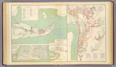 View larger, zoomable image (turn off pop-up blocker) Full Title: Galveston, Tex. and its fortifications. Map of siege operations against the defenses of Charleston Harbor, 1863 showing batteries covering the descent upon Morris Island, July 10 and the subsequent operations resulting in the demolition of Ft. Sumter, and the capture of Ft. Wagner and Batty. Gregg, September 7 ... 1863. Q. Gillmore, Major-General commanding and Chief Engineer .... Map of Port Hudson, La. and vicinity. Prepared by order of Major D.C. Houston, Chief Engineer, Department of the Gulf and Captain Peter C. Hains, Corps of Engr's., 1864. Julius Bien & Co., Lith., N.Y. (1891-1895) Author: Gillmore, Quincy A.; United States. War Department Date: 1895 This historical cartographic image is part of the David Rumsey Historical Map Collection, www.davidrumsey.com, a large collection of online antique, rare, old, and historical maps, atlases, globes, charts, and other cartographic items. Read more about the Collection. Or you can view the entire David Rumsey Map Collection in Insight. Full David Rumsey Map Collection Catalog Record: Author: Gillmore, Quincy A.; United States. War Department Date: 1895 Short Title: Galveston, Charleston Harbor, Port Hudson. Publisher: Washington: U.S. Government Printing Office Type: Atlas Map Object Height cm: 43 Object Width cm: 70 Scale 1: Various Note: Three col. maps. Relief shown by hachures; depths by soundings. State / Province: Texas ; South Carolina ; Louisiana City: Galveston (Tex.) Event: U.S. Civil War Subject: Military Full Title: Galveston, Tex. and its fortifications. Map of siege operations against the defenses of Charleston Harbor, 1863 showing batteries covering the descent upon Morris Island, July 10 and the subsequent operations resulting in the demolition of Ft. Sumter, and the capture of Ft. Wagner and Batty. Gregg, September 7 ... 1863. Q. Gillmore, Major-General commanding and Chief Engineer .... Map of Port Hudson, La. and vicinity. Prepared by order of Major D.C. Houston, Chief Engineer, Department of the Gulf and Captain Peter C. Hains, Corps of Engr's., 1864. Julius Bien & Co., Lith., N.Y. (1891-1895) List No: 1780.038 Page No: pl. XXXVIII Series No: 42 Engraver or Printer: Julius Bien & Co. ; Houston, David C. ; Hains, Peter C. Published In: Atlas to accompany the official records of the Union and Confederate armies. Published under the direction of the Hons. Redfield Proctor, Stephen B. Elkins and Daniel S. Lamont, secretaries of war, by Maj. George B. Davis, U.S. Army, Mr. Leslie J. Perry, civilian expert, Mr. Joseph W. Kirkley, civilian expert, Board of Publication. Compiled by Capt. Calvin D. Cowles, 23d U.S. Infantry. Washington: Government Printing Office, 1891-1895. Publication Author: United States. War Department; Davis, George B.; Perry, Leslie J.; Kirkley, JAW.; Cowles, Calvin D. Publication Date: 1895 Publication Reference: LC Civil War maps (2nd ed.), 99; Civil War maps in the National Archives, 8; Phillips, 1353; LeGear. Atlases of the United States, 266. Publication Note: See note field above. Publication List No: 1780.000 Publication Type: Military Atlas Publication Maps: 158 Publication Height cm: 47 Publication Width cm: 40 Image No: 1780038
Important!
The Insight® Browser and Java client software are products of Luna Imaging, Inc. If you have comments, suggestions, or need help, contact The David Rumsey Collection at home | about | view the
collection | recent
additions | news | help |
