
|
|
|
R.13-14E T.9-10S. (Thompson, Thos. H.), 1891
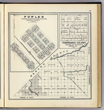 View larger, zoomable image (turn off pop-up blocker) Full Title: Range 13 East, Range 14 East, Township 10 South, T.P. 9 S. (with) Fowler ... (with) Temperance Colony ... (Compiled, drawn and published ... by Thos. H. Thompson, Tulare, California, 1891) Author: (Thompson, Thos. H.) Date: 1891 This historical cartographic image is part of the David Rumsey Historical Map Collection, www.davidrumsey.com, a large collection of online antique, rare, old, and historical maps, atlases, globes, charts, and other cartographic items. Read more about the Collection. Or you can view the entire David Rumsey Map Collection in Insight. Full David Rumsey Map Collection Catalog Record: Author: (Thompson, Thos. H.) Date: 1891 Short Title: R.13-14E T.9-10S. Publisher: Tulare: Thompson Thos. H. Type: Atlas Map Object Height cm: 35 Object Width cm: 33 Scale 1: 63,360 Note: Covers Rancho Sanjon de Santa Rita-Ash Slough-Chowchilla Canal region in present Madera County. Shows sections, quarter sections, owners (including Miller and Lux, California Pastoral and Agricultural Company and George D. Bliss) , etc. Fowler map at (1:4,800) shows block and lot numbers, etc. Temperance Colony map shows lot numbers, buildings, owners. State / Province: California County: Madera County (Calif.) City: Fresno (Calif.) ; Fowler (Calif.) Subject: U.S. Public Survey Full Title: Range 13 East, Range 14 East, Township 10 South, T.P. 9 S. (with) Fowler ... (with) Temperance Colony ... (Compiled, drawn and published ... by Thos. H. Thompson, Tulare, California, 1891) List No: 2867.015 Page No: 33 Series No: 18 Published In: Official historical atlas map of Fresno County. Office of the Board of Supervisors of Fresno County, California ... Compiled, drawn and published from personal examinations and surveys by Thos. H. Thompson, Tulare, California, 1891. Publication Author: Thompson, Thos. H. Publication Date: 1891 Publication Reference: LeGear. Atlases of the United States, L3932; Rocq, M.M. California local history (2nd ed.), 1840. Publication Note: See note field above. Publication List No: 2867.000 Publication Type: County Atlas Publication Maps: 87 Publication Height cm: 41 Publication Width cm: 38 Image No: 2867015
Important!
The Insight® Browser and Java client software are products of Luna Imaging, Inc. If you have comments, suggestions, or need help, contact The David Rumsey Collection at home | about | view the
collection | recent
additions | news | help |
