|
REFINE
Media Group: testtls
1-50 of 50
Author
Anonymous
Full Title
(Untitled Geographical/Astronomical Wheel).
List No
4213.000
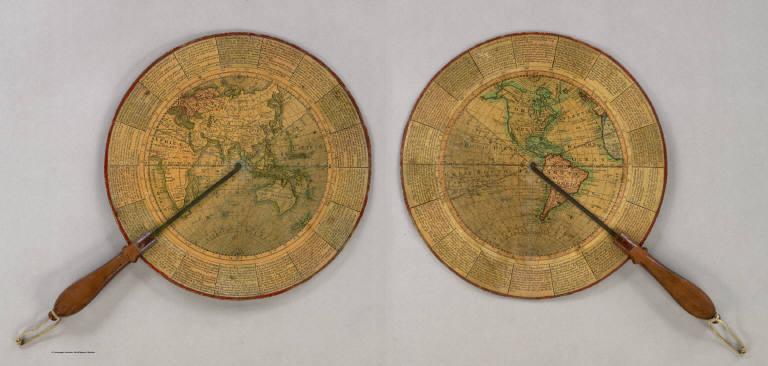
Note
Untitled, unauthored and undated varnished card wheel 11 3/4" in diameter, printed on both sides with hand colored highlighting, and mounted with a mahogany handle with brass alidades divided 0-90 degrees. Both terrestrial hemispheres are shown, with political, geographic and astronomical features in great detail. The circumference carries numerous definitions and instructions for use and calculation e.g. "To find the Azimuth of ye Sun at any given hour of the Day; To find the Space of Time during which there is no Dark Night; etc." A wonderful, most rare device.
Author
[American Globe & School Supply Co., Rand McNally and Company]
Full Title
American Globe & School Supply Co.'s New Six Inch Terrestrial Globe. Rand McNally & Co.'s New Six Inch Terrestrial Globe Copyright, 1892, By Rand, McNally & Co.
List No
5120.000
Note
Rand McNally issued their first globe in 1887 (Warner). Soon afterwards they were producing globe gores for other makers, in this example the American Globe & School Supply Co. of Seneca Falls, New York. Warner lists only one known example by American Globe, an 8 inch, 1891 globe also with Rand McNally gores. Their output must have been small and this 6 inch globe may be scarce. Total height from base to tip of the globe is ten inches.
Author
Andrews, A.H. & Co.
Full Title
Andrews Eight Inch Terrestrial Globe with the latest discoveries and Oceanic currents. A.H. Andrews & Co. Chicago, Ill.
List No
5517.000
Note
This eight inch globe is shown in full color with the continental United States shown separately and Alaska named as such. With a three -footed base and a horizon ring that includes the Zodiac signs and a calendar. Total height of base and globe is 15 inches. Date is estimated from Warner.
Author
[Abel, Henry J., Young, James H.]
Full Title
(Covers to) Traveller's & Emigrant's Guide to Wisconsin & Iowa. By Henry I. Abel. Accompanied With A New and Improved Map of those Territories. With The Addition of Parts of Illinois, Indiana, and Michigan.
List No
4046B
Author
[Abel, Henry J., Young, James H.]
Full Title
Map of the Settled Part of Wisconsin Territory compiled from the Latest Authorities by Aug. Mitchell. Philadelphia. Improved and Published by Henry J. Abel, of Wis. Ter. Compiled and Engraved by J.H. Young, Philada. 1838. (with) The Entire Territory of Wisconsin. As Established by Act of Congress. April 10, 1836.
List No
4046.001
Note
Maps in full color by county.
Author
[Abel, Henry J., Young, James H.]
Full Title
(Text Page in) Traveller's & Emigrant's Guide to Wisconsin & Iowa. By Henry I. Abel. Accompanied With A New and Improved Map of those Territories. With The Addition of Parts of Illinois, Indiana, and Michigan.
List No
4046A
Note
Note to the emigrants from the American Transportation Company.
Author
Anonymous
Full Title
United States.
List No
5442.000
Note
Outline color hand drawn map by a young student. A silk blue border has been sown onto map with silk hooks for hanging. Date estimated from geography of the west.
Author
Anonymous
Full Title
(Covers to) Drawing Teacher. Geography.
List No
5529A
Note
Box cover has a depiction of the United States in outline form. The instructions on the inside of the box state, "Follow all the openings in the pattern with a well and long pointed lead pencil or use a small stencil brush, taking care not to let the pattern slip, then finish and insert the names of the States and locate their Capital Cities."
Author
Anonymous
Full Title
The United States; North America; South America; Europe; Africa; Asia.
List No
5529.001
Note
Six maps made of stiff brown cardboard with country in outline, scale marker at the bottom and holes for the pinpointing of capitals and major cities.
Author
American Publishing Company
Full Title
Rambles Through Our Country. An Instructive Geographical Game For The Young. Copyright Secured 1881. American Publishing Company. Hartford, Conn. 1886.
List No
3886.000
Note
This is meant to accompany a board game with a map of the United States (see our #5086). However, it functions as a geography of the U.S. by itself. In full color.
Author
Abbot, Henry L.
Full Title
Official Plan of The Siege Of Yorktown Va. Conducted by the Army of the Potomac under the command of Maj. Gen. George B. McClellan U.S.A. April 5th to May 3rd 1862. Prepared under the direction of Brig. Gen J.G. Barnard Chief Engr. by Lieut. Henry L. Abbot Top. Engrs. A.D.C. ... Lith. by J.F. Gedney, Washn. Chas. G. Krebs, Engr.
List No
3860.000
Note
Large scale map showing the Confederate and Union batteries with Notes and Proposed Armament of Batteries. Without color. Plate 19:2 in "Atlas to Accompany..."
Author
Abbot, Henry L.
Full Title
Campaign Map, Army Of The Potomac. Map No. 3 White House To Harrisons Landing. Prepared By Command Of Maj. Gen. George B. McClellan, U.S.A. Commanding Army Of The Potomac Brig. Gen. A.A. Humphreys ... Compilation under the Direction of Brig. Gen. A.A. Humphreys, By Capt. H.L. Abbot, Top. Engrs. Engraved by W.H. Dougal.
List No
3877.000
Note
Shows troop positions near Richmond (Fair Oaks, etc.) and Harrisons Landing. List of Authorities given. See other two campaign maps in this series (our #3878, 3879). Date is estimated. Plate 19:1 in "Atlas to Accompany..." Without color.
Author
Abbot, Henry L.
Full Title
Campaign Map, Army Of The Potomac. Map No. 2 Williamsburg To White House. Prepared By Command Of Maj. Gen. George B. McClellan, U.S.A. Commanding Army Of The Potomac Brig. Gen. A.A. Humphreys ... Compilation under the Direction of Brig. Gen. A.A. Humphreys, By Capt. H.L. Abbot, Top. Engrs. Engraved by W.H. Dougal.
List No
3878.000
Note
The second in a series of three (see our #3877, 3879); without color. Date is estimated. Plate 100:3 in "Atlas to Accompany..."
Author
Abbot, Henry L.
Full Title
Campaign Maps, Army Of The Potomac. Map No. 1 Yorktown To Williamsburg. Prepared By Command Of Maj. Gen. George B. McClellan U.S.A. Commanding Army Of The Potomac Brig. Gen. A.A. Humphreys ... Compilation under the Direction of Brig. Gen. A.A. Humphreys, By Capt. H.L. Abbot, Top. Engrs. Engraved by W.H. Dougal.
List No
3879.000
Note
The first in a series of three (see our #3877 and 3878). Shows the entire peninsula south to Fortress Monroe. Indicates confederate defenses at Yorktown. Date is estimated. Plate 18:2 in "Atlas to Accompany..." Map is without color.
Author
Adams, George H. & Son
Full Title
(Covers to) Geo. H. Adams & Son Colorado. Copyright 1884, By Geo. H. Adams & Son, New York.
List No
4428A
Author
Adams, George H. & Son
Full Title
Geo. H. Adams & Son Colorado. Copyright 1884, By Geo. H. Adams & Son, New York.
List No
4428.001
Note
Scarce map by the Adams of Asher and Adams, in the style of the maps that appear in the magazine published by Adams, Descriptive America. The date is estimated by the number of counties, 42, although the copyright date is 1884. On the inside cover is a presentation: "Presented by His Excellency, Gov. Adams, Sept. 6th, 1887. T.N. Haskell." Alva Adams was Governor from 1886 to 1889 and 1896 to 1899. Uncolored except for printed red state and county boundary lines. A simple map with great clarity of detail; folded into golden brown cloth covers 17x11 with "Adams & Company's New Map Of Colorado." stamped in gold. Not in any references.
Author
[Alaska Exploration Company, Davidson, George]
Full Title
(Covers to) Map Showing Routes From San Francisco To Alaska And The Klondike. The Alaska Exploration Company, General Offices: Liebes' Building, 139 Post Street, San Francisco, Cal., U.S.A. 29 Queen Street, London, Eng. ... This map was compiled by Prof. Geo. Davidson, late Asst. Supt. U.S. Coast & Geodetic Survey. Copyright 1897. Dakin Pub. Co. Maps 320 Sansome St. S.F. (inset) Map Of The Klondike.
List No
3449A
Author
[Alaska Exploration Company, Davidson, George]
Full Title
Map Showing Routes From San Francisco To Alaska And The Klondike. The Alaska Exploration Company, General Offices: Liebes' Building, 139 Post Street, San Francisco, Cal., U.S.A. 29 Queen Street, London, Eng. ... This map was compiled by Prof. Geo. Davidson, late Asst. Supt. U.S. Coast & Geodetic Survey. Copyright 1897. Dakin Pub. Co. Maps 320 Sansome St. S.F. (inset) Map Of The Klondike.
List No
3449.001
Note
Inset gives nine reasons to outfit in San Francisco. Not found in any collections. Above map reads "Capacity Limited---Engage Passage and Freight Space Now---Prompt, Efficient Service." and below, "All Water Route---San Francisco to Dawson City and Points on the Yukon River via St. Michael---We take your Baggage and Freight with you." Full printed color. Folded into tan card board covers 18.5x9 with "Latest Complete Map Of Alaska And North West Canada Gold Fields. Published By The Alaska Exploration Company (Under management of H. Liebes & Co.) ... San Francisco, January 1, 1898."
Author
Alaska Steamship Company
Full Title
Territory of Alaska. The Alaska Line. The All-American Route, Alaska Steamship Company, Serving All of Alaska. Copyright 1936, Frank McCaffrey, Seattle. Printed in U.S.A. (with two inset maps)
List No
5300.000
Note
Map is in full printed color. Inset maps: 1) Untitled map of the area around Anchorage and the Gulf of Alaska. 2) Untitled map of North America showing the routes from the "lower 48" to Alaska. A table of distances is included showing the mileage from Seattle to places in Alaska. The border is bright and original with totem poles. Mt. McKinley National Park is highlighted in green.
Author
American Telephone and Telegraph Company
Full Title
(Covers to) Lines And Metallic Circuit Connections. American Telephone and Telegraph Company. 15 Dey St., New York September 1898. (inset) Maine.
List No
3791A
Author
American Telephone and Telegraph Company
Full Title
Lines And Metallic Circuit Connections. American Telephone and Telegraph Company. 15 Dey St., New York September 1898. (inset) Maine.
List No
3791.001
Note
Shows the United States west to Kansas. Completed and projected telephone lines are shown. On the verso is "List of Stations Connected by Metallic Circuit Lines With the Long Distance System." On the folded cover is the statement "1000 miles and return in 5 minutes. The mail is quick, telegraph is quicker; but Long Distance Telephone is Instantaneous and you don't have to wait for an answer." Folding into self wrappers 20x9.5, with "American Telephone and Telegraph Company. Long Distance Telephone. New York. Boston, Philadelphia, Pittsburg, Cincinnati, Chicago, St. Louis. General Offices 15 Dey St. New York."
Author
American Telephone and Telegraph Company
Full Title
(Covers to) Lines and Metallic Circuit Connections. American Telephone and Telegraph Co. 18 Cortlandt St. New York. March 1, 1891.
List No
5564A
Author
American Telephone and Telegraph Company
Full Title
Lines and Metallic Circuit Connections. American Telephone and Telegraph Co. 18 Cortlandt St. New York. March 1, 1891.
List No
5564.001
Note
The map shows the communication lines in orange. On the folded cover is the statement "500 miles and return in 5 minutes. The mail is quick; telegraph is quicker; but Long Distance Telephone is Instantaneous and you don't have to wait for an answer." On the back of the map is a list of public pay stations. Folding into self wrappers 20x9.5, with "New York, Boston, Buffalo, Washington. Local and Long Distance Telephone. American Telephone and Telegraph Company. General Offices, 18 Cortlandt St. New-York. John C. Rankin Co., 34 Cortlandt St. N.Y."
Author
Anderson, O.P. and Co.
Full Title
Anderson's New Guide Map Of The City Of Seattle And Environs, Washington. Compiled From Latest Official Records By O.P. Anderson And Co. Engineers and Draughtsmen. July, 1890. L.H. Everts, Phila. Pa. Prepared For Eshelman, Llewellyn & Co. Investment Brokers, Seattle, Washington. Entered ... 1890, by O.P. Anderson & Co. ... Washington, D.C. (untitled inset of the Seattle vicinity).
List No
4653.000
Note
This is somewhat later in the year than the "Whitney" version of this map (see our #4336) and show more property developments and more coverage on the east side of town. The smaller scale inset map of western Washington state is eliminated. Map in color by area.
Author
Anderson, P.
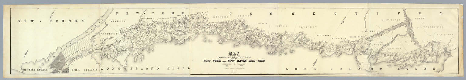
Full Title
Map Exhibiting The Experimental and Located Lines for the New-York and New-Haven Rail-Road ... Projected and Drawn by P. Anderson Civil Engr. Scale 1 to 40,000. Febr. 1845. Snyder & Black Lithogrs. 87 Fulton St. New-York.
List No
4218.000
Note
Greatly detailed strip map over ten feet long showing the surveyed routes of the New York and New Haven Railroad. The line was opened in 1849. The map is unique for a railroad map in its huge size, large scale, elegance of drawing, and variety of information shown (houses, trails, rivers, turnpikes, lighthouses, harbors, hills, swamps, etc.).
Author
Andriveau-Goujon, E.
Full Title
(Covers to) Carte Generale Des Etats - Unis Et Du Mexique Comprenant L'Amerique Centrale Et Les Antilles. E. Andriveau-Goujon, Editeur. Paris, Rue Du Bac, 21. 1865 ... (with four inset maps).
List No
2100A
Author
Andriveau-Goujon, E.
Full Title
Carte Generale Des Etats - Unis Et Du Mexique Comprenant L'Amerique Centrale Et Les Antilles. E. Andriveau-Goujon, Editeur. Paris, Rue Du Bac, 21. 1865 ... (with four inset maps).
List No
2100.001
Note
Third edition. Shows Colona, Shoshone, Nevada. The maker of this map must have seen copies of Mitchell's 1859 New National Map - this has the same proposed territorial names that Mitchell used that year. This also has a line dividing the northern and southern states in the civil war. According to Phillips Maps, this was also No. 48 in the Atlas Universel for 1862. Map is dissected into 21 sections and mounted on tan linen with the book plate of Andriveau-Goujon. Covers are dark green cloth 23.5x14.5 with "Etats-Unis Et Mexique. Andriveau-Goujon. Rue Du Bac, 2I." stamped in gold on the front with the same embossed gold and green globe as the 1862 issue. The spine is stamped with "Etats-Unis" in gold. Map has full color by state.
Author
Anson, W.
Full Title
(Covers to) Map Of Maine Constructed from the most Correct Surveys With Sectional Distances and Elevations or Level, of the St. Croix River from Calais Bridge. Deduced from the States Survey, Made by W. Anson, Civil Engineer, In 1836. Engraved & Published by by S.H. Colesworthy, Portland. 1843. Revised Edition.
List No
2964A
Author
Anson, W.
Full Title
Map Of Maine Constructed from the most Correct Surveys With Sectional Distances and Elevations or Level, of the St. Croix River from Calais Bridge. Deduced from the States Survey, Made by W. Anson, Civil Engineer, In 1836. Engraved & Published by by S.H. Colesworthy, Portland. 1843. Revised Edition.
List No
2964.001
Note
Later edition published in 1853. One of the first separately published maps of the state after the treaty of 1842 settled the border with Canada. Folded into black leather covers 13x8 with "Map Of Maine." stamped in gilt.
Author
Tanner, Henry S.
Full Title
(Title Page to) A Connected View of The Whole Internal Navigation of the United States; ... Corrected and Improved From the Edition of 1826, And Much Enlarged, ... With A Sheet Map, ... The Map Has Been Engraved For the Purpose ... On A Reduced Scale, From Tanner's Excellent Four Sheet Map of the United States, Recently Published. ... By a Citizen of the United States. Philadelphia: Published by the Author ... Printed by Lydia R. Bailey. 1830. (on verso) ...on the seventeenth day of April ... 1830, George Armroyd ... hath deposited ... a Book ... Pennsylvania.
List No
3067A
Author
Tanner, Henry S.
Full Title
A Connected View of The Whole Internal Navigation of the United States; ... Corrected and Improved From the Edition of 1826, And Much Enlarged, ... With A Sheet Map, ... The Map Has Been Engraved For the Purpose ... On A Reduced Scale, From Tanner's Excellent Four Sheet Map of the United States, Recently Published. ... By a Citizen of the United States. Philadelphia: Published by the Author ... Printed by Lydia R. Bailey. 1830. (on verso) ...on the seventeenth day of April ... 1830, George Armroyd ... hath deposited ... a Book ... Pennsylvania.
List No
3067.001
Note
2nd (and best) edition, first with Tanner's Map of the Canals and Railroads of the United States. The map is copyright 1830. The book lists over 150 canals and navigation improvements in great detail. The map shows the most important canals and two railroads in operation, and one proposed railroad (the Great Western Railroad, from New York to the Mississippi River)plus two others. The canals and railroad lines are in color. The first edition appeared in 1826 with 10 maps but without the Tanner map (see our copy #4214). Tanner in 1834 and 1840 (see our copies, #2655 and #979) published a book on Canals and Railroads that uses the same map, updated. Modelski lists the 1834 Tanner map as "one of the earliest general maps of the eastern United States showing railroads in operation." Since this 1830 copy is an earlier state of the same map, it probably qualifies as the true "first." Two folding plates of profiles of canals and railroads at the back. Not in Streeter, Eberstadt, or Graff. Bound in half leather boards with "A Connected View" on the spine.
Author
United States. Congress
Full Title
Map Of The San Joaquin, Sacramento And Tulare Valleys, State Of California, prepared under the direction of the Board Of Commissioners On Irrigation appointed under the Act of Congress approved March 3rd 1873, showing the country that may be irrigated and a Provisional System Of Irrigation Compiled from the Maps of the Geological Survey Of California and from Special Surveys and Examinations. 1873. Published by authority of the Hon. Secretary of War in the Office of the Chief of Engineers U.S. Army.
List No
4916.000
Note
This is another copy of the map that appears in the 1874 "Irrigation of the San Joaquin, Tulare, and Sacramento Valleys, in the State of California." (43rd Cong., 1st Sess., House Doc. No. 290). See our #1061. Printed in full color.
Author
Anville, Jean Baptiste Bourguignon d, 1697-1782
Full Title
(Covers to) (Atlas general) (Paris : Sr. D'Anville, 1771?)
List No
2603A
Note
Maps dated 1743-71. Most of D'Anville's atlases were made up for the individual customer, so it appears that no two are alike. Many of the maps are multisheet maps that have here been joined, so the actual map sheet count is about 45. This set is accompanied by a printed list of "Cartes Geographiques de M. D'Anville" with the maps numbered 1-38 in ms, corresponding to the maps in the atlas. This sheet also lists "Ouvrages par ecrit, et qui ont ete imprimes." One of the listed books is dated 1777. D'Anville's maps have a clarity and directness that is very "modern." He read widely, and incorporated the best available geographic knowledge into his work. The English and others copied from his maps extensively. Many of the maps were missing when we acquired this atlas, and have been added subsequently. Maps stored, some bound, in a binding with half leather and cloth ties. "Atlas" printed on the spine.
Author
Anville, Jean Baptiste Bourguignon d, 1697-1782
Full Title
(Index to) (Atlas general) (Paris : Sr. D'Anville, 1771?)
List No
2603B
Note
Engraved sheet inserted in atlas. Has title: Cartes geographiques de M. D'Anville, Premier Geographe du Roi, du Academie des Belles-Lettres et des Sciences, aux Galeries du Louvre, Rue de l'Ortie.
Author
Anville, Jean Baptiste Bourguignon d, 1697-1782
Full Title
Premiere partie de la Carte d'Europe contenant la France, l'Alemagne, l'Italie, l'Espagne & les Isles Britanniq(ue)s. Publiee sous les auspices de Monseigneur Louis Philippe d'Orleans, Duc d'Orleans et Premier Prince de Sang. Par le Sr. d'Anville de l'Academie Royale des Belles Lettres, et du celle des Sciences de Petersbourg, Secretaire de on. Alt. Seren? (Grave par) G. De la Haye. (Paris : Sr. d'Anville), MDCCLIV.
List No
2603.002
Note
Engraved map on 2 sheets. Relief shown pictorially. Ornamental cartouche by "N. Le Mire scul." Includes inset map. David Rumsey Collection mounted as 1 sheet. Political division boundaries hand col. "2" added by hand on verso.
Author
Anville, Jean Baptiste Bourguignon d, 1697-1782
Full Title
Seconde partie de la carte d'Europe, contenant le Danemark et la Norwege, la Suede et la Russie (a l'exception de l'Ukraine). Publiee sous les auspices de Monseigneur Louis Philippe d'Orleans, Duc d'Orleans, Premier Prince du Sang. Par le Sr. d'Anville, de l'Academie Rle. des Belles-Lettres, et de celle des Sc? de Petersbourg, Secretaire de Son Alt? Seren?. Grave par G. De la Haye. Sous le Privilege de l'Academie, chez l'Auteur, aux Galeries du Louvre, MDCCLVIII.
List No
2603.003
Note
Engraved map on 2 sheets. Relief shown pictorially. Ornamental cartouche by "N. Le Mire sculp." Includes inset map of Iceland. David Rumsey Collection mounted as 1 sheet. Political division boundaries hand col. "3" added by hand on verso.
Author
Anville, Jean Baptiste Bourguignon d, 1697-1782
Full Title
Troisieme partie de la carte d'Europe, contenant le midi de la Russie, la Pologne, et la Hongrie, la Turquie y compris celle d'Asie presqu'entiere. Publiee sous les auspices de Monseigneur Louis Philippe d'Orleans, Duc d'Orleans, Premier Prince du Sang. Par le Sr. d'Anville, de l'Academie Rle. des Belles Lettres, et de celle des Sc? de Petersbourg, Secretaire de Son Alt? Seren? (Grave par) De la Haye. Sous le Privilege de l'Academie, chez l'Auteur aux Galerie du Louvre, MDCCLX.
List No
2603.004
Note
Engraved map on 2 sheets. Relief shown pictorially. Ornamental cartouche by "J.P. Cheffard sculp." David Rumsey Collection mounted as 1 sheet. Political division boundaries hand col. "4" added by hand on verso.
Author
Anville, Jean Baptiste Bourguignon d, 1697-1782
Full Title
Premiere partie de la carte d'Asie, contenant la Turquie, l'Arabie, la Perse, l'Inde en deca du Gange et de la Tartarie, ce qui est limitrophe de la Perse et de l'Inde. Publiee sous les auspices de Monseigneur le Duc d'Orleans, Premier Prince du Sang. Par le Sr. d'Anville, MDCCLI. Grave par Guille. De-la-Haye. A Paris, ches l'Auteur aux Galeries du Louvre, avec Privil?
List No
2603.005
Note
Engraved map on 2 sheets. Country boundaries hand col. Relief shown pictorially. Includes geographic notes and ornamental cartouche by "H. Gravelot, invenit., DeLafosse, sculpsit." David Rumsey Collection copy mounted as 1 sheet. Hand numbered "5" on verso.
Author
Anville, Jean Baptiste Bourguignon d, 1697-1782
Full Title
Seconde partie de la carte d'Asie, contenant la Chine et partie de la Tartarie, l'Inde au dela du Gange, les isles Sumatra, Java, borneo, Moluques, Philippines, et du Japon. Publiee sous les auspices de Monseigneur Louis-Philippe d'Orleans, Duc d'Orleans, Premier Prince du Sang. Par le Sr. d'Anville, Secretaire de Son Alt? Sereniss? Guill? De la Haye Scul. A Paris, chez l'Auteur, aux Galeries du Louvre. M.DCC.LII.
List No
2603.006
Note
Engraved map on 2 sheets. Country boundaries hand col. Relief shown pictorially. Includes geographic notes and ornamental cartouche. David Rumsey Collection copy mounted as 1 sheet. Hand numbered "6" on verso.
Author
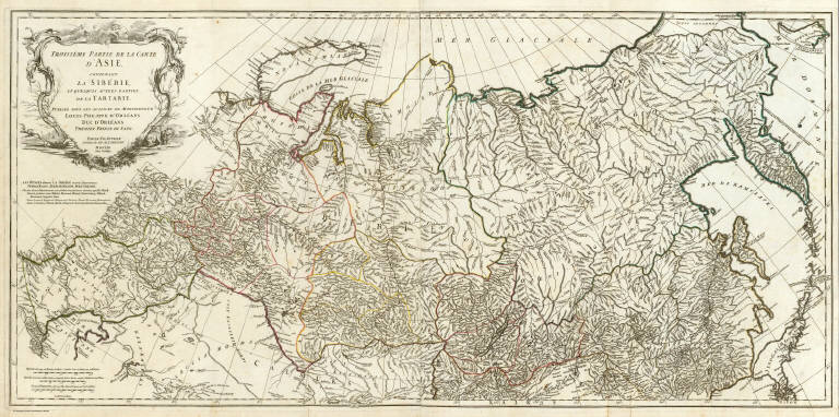
Anville, Jean Baptiste Bourguignon d, 1697-1782
Full Title
Troisieme partie de la carte d'Asie, contenant la Siberie, et quelques autres parties de la Tartarie. Publiee sous les auspices de Monseigneur Louis-Philippe d'Orleans, Duc d'Orleans, Premier Prince du Sang. Par le Sr. d'Anville, Secretaire de Son. Alt? Sereniss? Guill? De la Haye (sculp. A Paris, chez l'Auteur, aux Galeries du Louvre). M DCC LIII.
List No
2603.007
Note
Engraved map on 2 sheets. Country boundaries hand col. Relief shown pictorially. Includes geographic notes and ornamental cartouche by "H. Gravelot, invenit., DeLafosse sculpsit." David Rumsey Collection copy mounted as 1 sheet. Hand numbered "7" on verso.
Author
Anville, Jean Baptiste Bourguignon d, 1697-1782
Full Title
Afrique. (Northern section). Publiee sous les auspices de Monseigneur le Duc d'Orleans, Premier Prince du Sang. Par le Sr. d'Anville, M DCC XLIV. Avec Privilege. (Grave par Guill. Delahaye). A Paris, ches l'Auteur aux Galeries du Louvre.
List No
2603.008
Note
Engraved map on 2 sheets. Country boundaries hand col. Relief shown pictorially. Includes inset map of the Azores, geographic notes and ornamental cartouche. David Rumsey Collection copy mounted as 1 sheet. "No.9 Afrique 1" added by hand on verso.
Author
Anville, Jean Baptiste Bourguignon d, 1697-1782
Full Title
(Afrique. Southern section. Publiee sous les auspices de Monseigneur le Duc d'Orleans, Premier Prince du Sang. Par le Sr. d'Anville, M DCC XLIV. Avec Privilege). Grave par Guill. Delahaye. (A Paris, ches l'Auteur aux Galeries du Louvre)
List No
2603.009
Note
Engraved map on 2 sheets. Country boundaries hand col. Relief shown pictorially. Includes geographic notes. David Rumsey Collection copy mounted as 1 sheet. "No. 9 Afrique 2" added by hand on verso.
Author
Anville, Jean Baptiste Bourguignon d, 1697-1782
Full Title
(Composite of) Afrique. Publiee sous les auspices de Monseigneur le Duc d'Orleans, Premier Prince du Sang. Par le Sr. d'Anville, M DCC XLIV. Avec Privilege. Grave par Guill. Delahaye. A Paris, ches l'Auteur aux Galeries du Louvre.
List No
2603.010
Note
Engraved map on 4 sheets. Country boundaries hand col. Relief shown pictorially. Includes inset map of the Azores, geographic notes and ornamental cartouche. David Rumsey Collection copy mounted as 2 sheets. "No. 9 Afrique ..." added by hand on versos.
Author
Anville, Jean Baptiste Bourguignon d, 1697-1782
Full Title
Amerique Septentrionale. (Northern section). Publiee sous les auspices de Monseigneur le Duc d'Orleans, Premier Prince du Sang. Par le Sr. d'Anville, M DCC XLVI (i.e., 1763?) Avec Privilege. (Gravee par Guill? Delahaye). A Paris, chez l'Auteur, aus Galeries du Louvre.
List No
2603.011
Note
Engraved map printed on 2 sheets. Boundaries hand col. Shows boundaries of Treaty of 1763 and Ft. Duquesne. Includes geographic notes and inset map of northeastern Canada and a part of Greenland. Relief shown pictorially. Ornamental cartouche: Du dessein du Sr. Gravelot, frere de l'Auteur; grave par le Sr. Major. David Rumsey Collection copy mounted as 1 sheet. Hand numbered "19" on verso; numbered 10 on index sheet.
Author
Anville, Jean Baptiste Bourguignon d, 1697-1782
Full Title
(Amerique Septentrionale. Southern section. Publiee sous les auspices de Monseigneur le Duc d'Orleans, Premier Prince du Sang. Par le Sr. d'Anville, M DCC XLVI (i.e., 1763?) Avec Privilege). Gravee par Guill? Delahaye. (A Paris, chez l'Auteur, aus Galeries du Louvre)
List No
2603.012
Note
Engraved map printed on 2 sheets. Boundaries hand col. Shows boundaries of Treaty of 1763. Includes geographic notes. Relief shown pictorially. David Rumsey Collection copy mounted as 1 sheet. Hand numbered "20" on verso; numbered 10 on index sheet.
Author
Anville, Jean Baptiste Bourguignon d, 1697-1782
Full Title
(Composite of) Amerique Septentrionale. Publiee sous les auspices de Monseigneur le Duc d'Orleans, Premier Prince du Sang. Par le Sr. d'Anville, M DCC XLVI (i.e., 1763?) Avec Privilege. Gravee par Guill? Delahaye. A Paris, chez l'Auteur, aus Galeries du Louvre.
List No
2603.013
Note
Engraved map printed on 2 sheets. Boundaries hand col. Shows boundaries of Treaty of 1763 and Ft. Duquesne. Includes geographic notes and inset map of northeastern Canada and a part of Greenland. Relief shown pictorially. Ornamental cartouche: Du dessein du Sr. Gravelot, frere de l'Auteur; grave par le Sr. Major. David Rumsey Collection copy mounted as 2 sheets. Hand numbered 19 and 20 on verso; numbered 10 on index sheet.
Author
Anville, Jean Baptiste Bourguignon d, 1697-1782
Full Title
(Amerique Meridionale. Northern section. Publiee sous les auspices de Monseigneur le Duc d'Orleans, Premier Prince du Sang. Par le Sr. d'Anville, M DCC XLVIII Avec Privilege. Grave par Guill? Delahaye. A Paris, chez l'Auteur, aux Galeries du Louvre)
List No
2603.014
Note
Engraved map. Boundaries hand col. Relief shown pictorially. Includes geographical notes. Northernmost of 3 sheets. Hand numbered 21 on verso; 12 on index sheet.
Author
Anville, Jean Baptiste Bourguignon d, 1697-1782
Full Title
(Amerique Meridionale. Central section. Publiee sous les auspices de Monseigneur le Duc d'Orleans, Premier Prince du Sang. Par le Sr. d'Anville, M DCC XLVIII Avec Privilege. Grave par Guill? Delahaye. A Paris, chez l'Auteur, aux Galeries du Louvre)
List No
2603.015
Note
Engraved map. Boundaries hand col. Relief shown pictorially. Includes geographical notes. Central sheet of 3. Hand numbered 22 on verso; 13 on index sheet.
Author
Anville, Jean Baptiste Bourguignon d, 1697-1782
Full Title
Amerique Meridionale. (Southern section). Publiee sous les auspices de Monseigneur le Duc d'Orleans, Premier Prince du Sang. Par le Sr. d'Anville, M DCC XLVIII Avec Privilege. Grave par Guill? Delahaye. A Paris, chez l'Auteur, aux Galeries du Louvre.
List No
2603.016
Note
Engraved map. Boundaries hand col. Relief shown pictorially. Includes geographical notes. Ornamental cartouche "Du Dessin du Sr. Gravelot, frere du l'Auteur. Hand numbered 23 on verso; 13 on index sheet.
Author
Anville, Jean Baptiste Bourguignon d, 1697-1782
Full Title
Hemisphere Occidental ou du Nouveau Monde. Hemisphere Oriental ou de l'Ancien Monde. Publie sous les auspices de Monseigneur Louis Philippe, Duc d'Orleans, Premieu Prince du Sang. Par le Sr. d'Anville, de l'Academie Royale des Belles Lettres, et de celle des Sciences de Petersbourg, Secretaire de S? Alt? Ser? MDCCLXI. Sous le Privilege de l'Academie.
List No
2603.001
Note
"Double hemisphere engraved map on 2 sheets. Relief shown pictorially. Continental boundaries hand col. ""1"" added by hand on verso."
1-50 of 50
|