|
Full Title
Outline and index map of the city of Cambridge. (1903)
List No
3818.001
Note
Index map. Hand colored lithograph. Includes legend. Oriented with north toward upper left. David Rumsey Collection copy: the name "Hubbard Pk" added in pencil.
Full Title
Generalitez & elections (France). (title in cartouche) Il y a dans le Royaume 25 Generalitez & elections ... Avec privilege du Roi. (1693)
List No
3658.051
Note
Engraved map. Boundaries hand colored. Includes note. Prime meridian: Ferro. On verso "49" and title "Generalitez & elections."
Author
Blaeu, Joan, 1596-1673
Full Title
(View of) [Subterranean holes near Tilbury]
List No
10017.320
Author
Aspioti-ELKA (Firm)
Full Title
(Text Page to) 17. H ΔEYTEPA ΦAΣIΣ THΣ KATOXHΣ = DEUXIÈME PHASE DE L'OCCUPATION = SECOND PHASE OF THE OCCUPATION = BTOPOЙ ПEPИOД OKKYПAЦИИ.
List No
14295.042
Note
Descriptive text accompanying the map of Greece on facing page, [Second phase of the Occupation]. With parallel text in Greek, French, English and Russian. (Titles in all capitals.) Description begins: When Italy asked for an armistice, Greece was divided between the Germans, who also used Italian troops, and the Bulgarians, who entered the country through Yugoslavia also, and took to destroying and massacring in order to change the sentiments of the population ... Within the second section of the atlas, Greece at war.
Vasi, Giuseppe Agostino Pietro, 1710-178... Text: V.3: Libro nona: (Continues) Della... 1759 13008.577 Related Author
Vasi, Giuseppe Agostino Pietro, 1710-1782
Full Title
(Text Page to) Delle magnificenze di Roma antica e moderna : Libro nono : nono che contiene i collegj, spedali, e luoghi pii. Dedicato all'eminentissimo, e Reverendissimo Principe il signor Cardinale Neri Corsini ... Da Giuseppe Vasi ... In Roma Nella Stamperia di Niccolo, e Marco Pagliarini, MDCCLIX (1759). Con Licenza de Superiori.
List No
13008.577
Note
Continues: Descriptive text to "tavola CLXV. il Seminario Romano."
Braun, Georg, 1541-1622; Hogenberg, Fran... Vol IV (4) Matiscona (Macon). Cabillinum... 1588 12126.374 Related Author
[Braun, Georg, 1541-1622, Hogenberg, Franz, 1539-1590]
Full Title
Vol IV (4) Matiscona (Macon). Cabillinum (Chalon-sur-Saone).
List No
12126.374
Note
In this last edition of Volume IV, van der Krogt 41:1.4 (1635), the preliminary matter after the title page is dropped.
Author
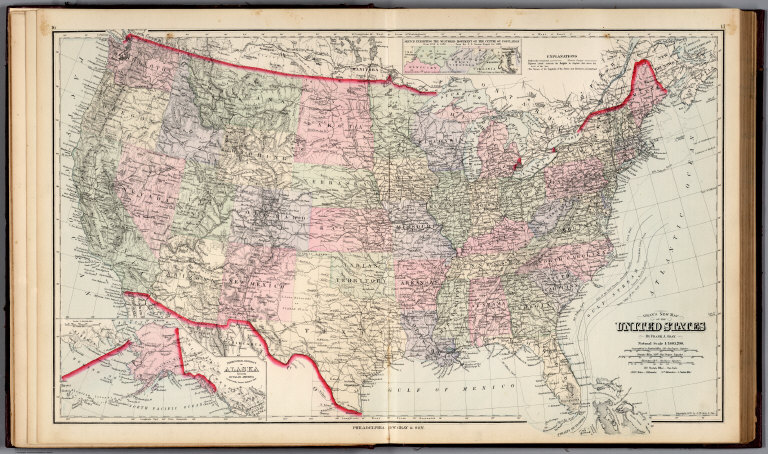
[Colton, J. H., Smith, J. Calvin]
Full Title
Colton's Township and Railroad Map Of The United States Of America Including a Large Portion of Canada, New Brunswick &c. Showing the Base Meridian and Township Lines of the U.S. Surveys. Rail Roads and other Internal Improvements. Compiled from surveys of the United States Land Office, and various other authentic sources. Published by J.H. Colton, 172 William St. New York. 1862. Entered ... 1843 by Geo. E. Sherman & J. Calvin Smith ... New York. Entered ... 1860 by J.H. Colton ... New York ... (inset) Map Of North America. (inset) Southern Part Of Florida.
List No
10277.000
Note
This is a late edition of the Colton/Smith map of the United States, first issued in 1843. Smith's name is removed and the title is modified to emphasize railroad development. No mention of the Civil War is made on the map even though the map was published during the fighting. There are many updates to the geography, showing new states and territories as well as railroads.
Author
U.S. Navy
Full Title
Ice Chart, Grand Banks Region, March.
List No
1103.021
Ewald, Ludwig 1813-1881; Bauerkeller, Ge... No. 66. Griechenland und die Jonischen I... 1858 12189.100 Related Author
[Ewald, Ludwig 1813-1881, Bauerkeller, Georg Leonhart]
Full Title
No. 66. Griechenland und die Jonischen Inseln.
List No
12189.100
Author
G.W. Bromley & Co.
Full Title
(Index to) Atlas of Westchester County, N.Y. Pocket, desk and automobile edition. Volume I. Mt. Vernon, Pelham, New Rochelle, Mamaroneck, Rye, Harrison, White Plains, Scarsdale and Eastchester. 1914. G.W. Bromley & Co., 34 Pine Street, New York. Copyright 1914.
List No
2318J
Note
Street index continued on 2 pages.
Author
Ashby, Janice
Full Title
A Map of the Stellenbosch areas as defined for the production of Wines of Origin..
List No
12460.000
Note
Wine map.
Author
Debenham, Frank
Full Title
(Text Page to) On the Land. (with inset view).
List No
1794.046
Note
Text with color and black and white views of tools and instruments used in exploration and observation, cartography, and surveying.
Author
Curtis Publishing Company
Full Title
(Statistical Table) Cleveland.
List No
9687.034
Whitney, J.D.; California Geological Sur... Title Page: The Yosemite Guide-Book. 1869 4212.004 Related Author
[California Geological Survey, Whitney, J.D.]
Full Title
(Title Page) The Yosemite Guide-Book: A Description of the Yosemite Valley and the Adjacent Region of the Sierra Nevada, and of the Big Trees of California, Illustrated With Maps and Woodcuts. Geological Survey of California. J.D. Whitney, State Geologist. Published by Authority of the Legislature. 1869.
List No
4212.004
Author
[Geve, Nicolaus Georg, Schultze, Johann Dominik 1751-]
Full Title
Tab. XV. Geve. Pinxit.
List No
14324.020
Note
Tab. XV to Belustigung im Reiche der Natur. Includes Figures 133-146b. Each figure is a detailed illustration of a shell, through delicate hand-painted copperplate engravings, in a pastel palette. Illustrations described in Classe seconde, Famille Seconde, Chapitre second, Section seconde through Section sixiéme, which all together span pages 99-108.
Author
Maire, Nicolas M.
Full Title
(Composite Text) La topographie de Paris, ou, Plan detaille de la ville de Paris et de ses faubourgs : compose de vingt feuilles, d'un tableau d'assemblage, et d'une table alphabetique et statistique des rues, ruelles, culs-de-sac, passages, quais, places, carres, carrefours ... : compose de vingt feuilles, d'un tableau d'assemblage, et d'une table alphabetique et statistique ... Dediee a Mme Maret, ... Par Maire. A Paris, Chez l'Auteur, rue de Tournon, no 7 : Et chez les principaux libraires. M DCCC VIII (1808).
List No
13045.005
Note
Composite pages 1-104: Alphabetical and topographical table.
Schlieben, Wilhelm Ernst August; Hermann... Covers: Atlas von Europa : V.1:1-5 Liefe... 1825 8328.001 Related Author
[Schlieben, Wilhelm Ernst August, Hermann, O.]
Full Title
(Covers to) Atlas von Europa nebst den Kolonien : fur Geschaftsmanner, Zeitungsleser und Besitzer des Conversations-Lexicons in einer Folge von Charten und einem alphabetisch eingerichteten Texte : bearbeitet von W. E. A. v. Schlieben ... Leipzig bei Georg Joachim Goschen 1825. O. Hermann, Lith.
List No
8328.001
Note
Early topographical map of Europe, together with the colonies for businessmen, newspaper readers ... by German geographical author, Wilhelm August von Schlieben (1781-1839), published in parts from 1825, in 3 volumes, and 15 parts; volume 1: 1-5, Volume 2: 6-10, Volume 3: 11-15. Each volume includes outline hand colored maps, manuscript index, forward, table of content, extensive descriptive text and index. Bound in half leather green marbled paper covered boards measuring 26.5x34.5, with "Atlas von Europa ... Lieferung" embossed on the spine.
Author
Pittman, Philip, active 1760-1770
Full Title
(Text Page to) Of the River Missisippi. (3)
List No
14327.008
Note
Historical and descriptive text on the Mississippi River. Text begins: The river Missisippi has been known by a variety of names; the first discoveries from Canada gave it the name of Colbert, in honour to that great minister, who was then in power ... But its present general appellation of Missisippi is a corruption of Metchasippi; by which name it is still known to the Northern Savages, that word signifying, in their language, the Father of Rivers. Text spans pages [1]-7.
Author
[Sohr, Karl, Berghaus, Heinrich, 1797-1884, Handtke, Friedrich, 1815-1879]
Full Title
Spanien und Portugal. Druck und Verlag v. C. Flemming in Glogau. (to accompany) Sohr-Berghaus Hand-Atlas uber alle Theile der Erde. Ausgefuhrt unter Leitung von F. Handtke ... 1875.
List No
11639.053
Note
Lithographic outline hand colored map. Shows political and administrative divisions, major cities, towns, roads, railroads, rivers and mountains. Relief shown by hachures. Includes legend and tables.
Oberkommando der Wehrmacht (OKW) (Nazi G... View: 43. Die Bucht von Langstone Harbou... 1941 7808.121 Related Author
Oberkommando der Wehrmacht (OKW) (Nazi German Supreme Command of the Armed Forces)
Full Title
(View) 43. Die Bucht von Langstone Harbour, Hampshire (BB 38).
List No
7808.121
Author
Mount and Davidson
Full Title
A Chart of New York Harbour with the Banks Soundings and Sailing marks from the most Accurate Surveys and Observations.
List No
12434.026
Note
A fine sea chart of New York Harbor which replaced Mark Tiddeman's outdated Draught of New York, which had appeared in early editions of this work since 1732.
Author
Paulli, Simone
Full Title
(Text Page to) Nobilissimus, amplissimis, pridentissimis et consultissimis viris, Domino Joanni Blaeu ... (1)
List No
14490.003
Note
Brief dedication for Orbis terraqueus in tabulis geographicis et hydrographicis descriptus. Spans two pages. (Page number inferred.)
Author
Schlieben, Wilhelm Ernst August von (1781 - 1839)
Full Title
Australien.
List No
12250.006
Author
Adams, Sebastian C.
Full Title
(Page 7) Adams' Synchronological Chart of Universal History. Through the Eye to the Mind. A Chronological chart of Ancient, Modern and Biblical History, Synchronized by Sebastian C. Adams. Third Edition and Twelfth-Thousand carefully and critically revised and brought down to 1878. Colby & Co. Publishers, 39 Union Square, New York. The Strowbridge Lithographing Company, Cincinnati, O. Entered According to Act of Congress in the Year A.D. 1871, by S.C. Admas, in the Office of the Librarian of Congress at Washington, D.C. (On the title page) Adams' Synchronological Chart of Universal History...Through the Eye to the Mind.
List No
6000.008
Note
A huge and impressive twenty three foot long chart showing 5,885 years of history, from 4004 B.C.. to 1881 A.D. First issued in 1871, Adams put out several editions in many formats. Rosenberg and Grafton in "Cartographies of Time" say that as a timeline, Adams Synchronological Chart "was ninetheenth-century America's surpassing achievement in complexity and synthetic power."
Author
Dutton, Clarence E. (Clarence Edward), 1841-1912
Full Title
(View) Pl. X. The Eastern Tempple.
List No
2147.029
Author
Hitchcock, Edward, 1828-1911
Full Title
Telerpeton Elginense. From the old red sandstone -- Chelonian footmarks. From old red sandstone ... W. C. Sharp's Lith. Boston (5).
List No
2132.008
Note
Black and white lithographs of fossils illustrating the text in Hitchock's Geology of the globe, published in Boston, 1853. Each illustration numbered in association with the text. Fifth of six pages, featuring illustrations 70 through 80. (Title and statement of responsibility taken from first page of illustrations.)
Author
Finley, Anthony
Full Title
The Places Recorded in the Five Books of Moses. Thackara Sculpt. Published by A. Finley Philada. 1827. (with) Two inset maps: Canaan Aram & c. and The Eastern Countries as mentioned by Moses.
List No
0285.069
Note
Each map in full color with the main map detailing the route of Moses in the desert after the flight from Egypt.
Author
Davis, F.A.
Full Title
(Text Page) Lehigh County Patrons' Directory.
List No
3745.047
Author
Tanner, Henry S.
Full Title
Lower Canada. (inset) Nova Scotia, New Brunswick &c.
List No
0980.008
Note
Datre estimated.
Author
Burr, David H., 1803-1875
Full Title
(Text Page) A Statistical View According to the Latest Census. County of Tompkins (New York).
List No
0105.093
Author
Reichsamt fur Landesaufnahme
Full Title
Sheet 222. Schneidemuehl. Karte des Deutschen Reiches.
List No
5820.222
Note
Date estimated based on the apparent library acquisition date usually stamped on the back of the map sheet. Mounted on linen in 4 panels. Publishing bookstore and distributor: R. Eisenschmidt, Verlags-Buchhandlung. Haupt-Vertrieb der Karten der Konigl. Landes-Aufnahme. Armee- und Marine-Haus. Berlin N.W., 7. Comparing our sheets to those at the Library of Congress shows that most of our sheets were published 5 to 10 years before the stamped acquisition date. A few sheets are duplicated and placed under similar list numbers. This map series is remarkable for the level of fine detail. As a consequence, it was scanned at 800 PPI providing four times the resolution of the typical detailed map scan of 400 PPI. At least ten separate symbols for special buildings were utilized, a method enhanced by placing an abbreviation next to the symbol. Structures with special symbols include: churches, chapels, monuments, windmills, water mills, stamp mills, forester's lodges, watchtowers, ruins, forts, quarries, clay pits, lime kilns, and coke-ovens. Factories, brick works, powder magazines electric power plants, and many other important buildings are differentiated by means of abbreviation. Houses appear as black blocks, either rectangular or shaped like the ground plan of the building. Many other features are differentiated, for example there are four different qualities of roads plus bridle paths and footpaths. Vegetation is minutely classified including separate symbols for broadleaf trees, evergreens, underbrush, heather, dry meadows, wet meadows, swamps, orchards, gardens, vineyards, and parks. Relief is shown by hachures. Spot elevations are given in meters above sea level.
Bartholomew, J.G.; Clarke, W. Eagle; Gri... Plate 25. Pisces - Teleostel (Bony Fishe... 1911 12429.035 Related Author
[Bartholomew, J.G., Clarke, W. Eagle, Grimshaw, Percy H.]
Full Title
Plate 25. Pisces - Teleostel (Bony Fishes); Holostei; Chondrostei.
List No
12429.035
Dutton, Clarence E. (Clarence Edward), 1... Pl. IV. Grand Canyon Platform and the Su... 1882 2147.019 Related Author
Dutton, Clarence E. (Clarence Edward), 1841-1912
Full Title
Pl. IV. Map of the Grand Canyon Platform and the Surrounding Mesozoic Formations.
List No
2147.019
Note
Color.
Author
[Berezin, A.D., 9]
Full Title
Transportnaia set' SSSR. 3. Transport. (to accompany) Sotsialisticheskoe Stroitel'stvo Soyuza Sovetskikh Sotsialisticheskikh Respublik.
List No
13676.072
Note
Statistical diagrams, showing transportation network of the USSR, 1928-1936.
Full Title
Port Chester. (G.W. Bromley & Co., 34 Pine Street, New York, 1914)
List No
2318.128
Note
Two hand colored maps on facing pages. Maps in this atlas show buildings (by construction material and function), water mains, hydrants, sewers, trolley lines, lot numbers and dimensions, house numbers, block numbers, owners of large parcels, etc. Includes Rockwood Park and Fox Island.
Author
Australia. Antarctic Division
Full Title
(Text Page to) Antarctica and the southern ocean. Edition 9. Produced in March 2011 for the Australian Antarctic Division. Map no. 13939. (Cover title) Antarctica : Map. Edition Nine. 1:20 M. (inset) Antarctic Peninsula stations. Scale 1:10 000 000.
List No
11698.002
Note
Color map on sheet 42x59.5, folded into 30x21. Showing scientific stations, exposed rocks, ice shelves, and iceberg tongues. Polar stereographic projection. Relief shown by shading, bathymetric tints, contours and spot heights. Notes: The topography of Antarctica has been derived from the Antarctic Digital Database published by the Scientific Committee on Antarctic Research (SCAR), 1993." "The bathymetry is reproduced from the GEBCO Digital Atlas published by the British Oceanographic Centre on behalf of the IOC and IHO, 1994." On verso: Text, color photos, distance chart and map "Antarctica : claim and treaty boundaries".
Author
Siebold, Phillip Franz von
Full Title
(Text page to) NIPPON. ARCHIV ZUR BESCHREIBUNG VON JAPAN VOLLSTÄNDIGER NEUDRUCK DER URAUSGABE ZUR ERINNERUNG AN PHILIPP FRANZ VON SIEBOLDS ERSTES WIRKEN IN JAPAN 1823-1830 IN ZWEI TEXT- UND ZWEI TAFELBÄNDEN. DAZU EIN NEUER ERGÄNZUNGS- UND INDEXBAND VON DR. F. M. TRAUTZ HERAUSGEGEBEN VOM JAPANINSTITUT BERLIN (JAPAN. ARCHIVE TO DESCRIPTION OF JAPAN COMPLETE REPRINT OF THE FIRST EDITION IN MEMORIAM PHILIPP FRANZ VON SIEBOLDS FIRST WORK IN JAPAN 1823-1830 IN TWO TEXT AND TWO TABLE VOLUMES. INTO A NEW ONE SUPPLEMENTARY AND INDEX VOLUME BY DR. F. M. TRAUTZ ISSUED BY THE JAPAN INSTITUTE BERLIN)
List No
15438.407
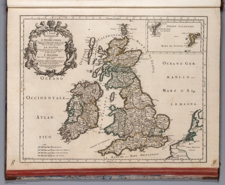
Cassini, Gio. Ma. (Giovanni Maria), 1745... (55) Le Isole Britanniche antiche cioe' ... 1799 14000.227 Related Author
Cassini, Gio. Ma. (Giovanni Maria), 1745-approximately 1824
Full Title
(55) Le Isole Britanniche antiche cioe' la Britannia Maggiore o sia Albione e la Britannia Minore o sia Ivernia. In Roma, presso la Calcografia Camerale, 1799.
List No
14000.227
Note
Relief shown pictorially. Includes decorative title cartouche and bar scales. In Volume III.
United States. Post Office Department Post Route Map of the State of Pennsylva... 1936 9196.000 Related Author
United States. Post Office Department
Full Title
Post Route Map of the State of Pennsylvania (Eastern Sheet) Showing Post Offices with the Intermediate Distances on Mail Route ... March 1, 1936. (insets) Philadelphia & Vicinity. Pittsburgh & Vicinity.
List No
9196.000
Vasi, Giuseppe Agostino Pietro, 1710-178... Text: V.3: Libro nona: Della tavola CLXX... 1759 13008.595 Related Author
Vasi, Giuseppe Agostino Pietro, 1710-1782
Full Title
(Text Page to) Delle magnificenze di Roma antica e moderna : Libro nono : nono che contiene i collegj, spedali, e luoghi pii. Dedicato all'eminentissimo, e Reverendissimo Principe il signor Cardinale Neri Corsini ... Da Giuseppe Vasi ... In Roma Nella Stamperia di Niccolo, e Marco Pagliarini, MDCCLIX (1759). Con Licenza de Superiori.
List No
13008.595
Note
Descriptive text to "tavola CLXXII. lo Spedale di S. Gio. in Laterano."
Vasi, Giuseppe Agostino Pietro, 1710-178... V.3: Libro nona: 175: Ospizio e Chiesa d... 1759 13008.605 Related Author
Vasi, Giuseppe Agostino Pietro, 1710-1782
Full Title
Ospizio e Chiesa di S. Luigi della Nazione Francese. G. Vasi dis. ed. Inc. 175. (to accompany) Delle magnificenze di Roma antica e moderna : Libro nono … In Roma, MDCCLIX (1759).
List No
13008.605
Note
Engraved view of the Church and hospice of St. Louis of France.
Grosvenor, Melville Bell; Darley, James ... Antarctica. Atlas Plate 65, February 196... 1963 11700.000 Related Author
[Grosvenor, Melville Bell, Darley, James M., National Geographic Society (U.S.). Cartographic Division.]
Full Title
Antarctica. Atlas Plate 65, February 1963. Compiled and Drawn in the Cartographic Division of the National Geographic Society for the National Geographical Magazine. Melville Bell Grosvenor, Editor ; James M. Darley, Chief Cartographer. Azimuthal Equidistent Projection. Printed by R.R. Donnelley and Sons Company, Chicago. (insets) Relative size of Antarctica and the United States. (with) Relation of Antarctica to the surrounding continents. (with) Queen Maud Range. (with) McMurdo Sound.
List No
11700.000
Note
Color map of Antarctica. Published as supplement to National Geographic Magazine, Atlas plate 65, 1963 . Relief shown hachures, spot heights and shading. Depth curves and soundings in fathoms. Azimuthal equidistant projection. Depth shown by bathymetric tints, isolines and soundings. Map showing ocean currents and wind, glaciers, ice stations. Includes many historical notes concerning the discovery and exploration of the continent.
Author
Ordnance Survey Office
Full Title
London Sheet VIII.83
List No
6752.372
Note
The Ordnance Survey London, Five feet to the Mile maps were published between 1893-1896, using a process pioneered by the Ordnance Survey called photozincography, a form of lithography. This set of 753 maps is owned by the National Library of Scotland (NLS). Scans and georeferenced images were generously provided to us in 2014 as part of a joint project under the guidance of Christopher Fleet, Senior Map Curator at the NLS. This set of maps includes 753 of the original 759 map set. For more detailed information on the London, Five feet to the Mile maps, see the excellent summaries and map presentations on the NLS website, http://maps.nls.uk/os/london-1890s/index.html
Author
Aspioti-ELKA (Firm)
Full Title
(Text Page to) 70. H OMAΔIKH TAΦH = ENTERREMENT EN MASSE = MASS BURIALS = OБЩEE ПORPEБEHИE.
List No
14295.154
Note
Descriptive text accompanying the photographs picturing Greece on facing page, [Mass burials]. With parallel text in Greek, French, English and Russian. (Titles in all capitals.) Description begins: The number of dead was so great that they could only be buried in mass graves ... Within the sixth section of the atlas, The sufferings of the inhabitants. WARNING: The following images are difficult to see, due to their graphic documentation of death.
Author
Reichsamt fur Landesaufnahme
Full Title
Sheet 492. Hof. Herausgegeben vom topogr. Bureau des Konigl. Sachs. Generalstabes. 1881. Karte des Deutschen Reiches.
List No
5820.492
Note
Mounted on linen in 6 panels. 1882. Edition of 1893. Embossed coat of arms for topographic service. Elevation numbers are metric above sea level. Label has key to adjacent sheets. Mounted on brown fragile linen. Paper sliced to accommodate turning the left and upper margins under and matching with adjoining sheets. Comparing our sheets to those at the Library of Congress shows that most of our sheets were published 5 to 10 years before the stamped acquisition date. A few sheets are duplicated and placed under similar list numbers. This map series is remarkable for the level of fine detail. As a consequence, it was scanned at 800 PPI providing four times the resolution of the typical detailed map scan of 400 PPI. At least ten separate symbols for special buildings were utilized, a method enhanced by placing an abbreviation next to the symbol. Structures with special symbols include: churches, chapels, monuments, windmills, water mills, stamp mills, forester's lodges, watchtowers, ruins, forts, quarries, clay pits, lime kilns, and coke-ovens. Factories, brick works, powder magazines electric power plants, and many other important buildings are differentiated by means of abbreviation. Houses appear as black blocks, either rectangular or shaped like the ground plan of the building. Many other features are differentiated, for example there are four different qualities of roads plus bridle paths and footpaths. Vegetation is minutely classified including separate symbols for broadleaf trees, evergreens, underbrush, heather, dry meadows, wet meadows, swamps, orchards, gardens, vineyards, and parks. Relief is shown by hachures. Spot elevations are given in meters above sea level.
Author
Nirenstein, Nathan
Full Title
(Text Page) Stockton, California.
List No
12506.049
Note
Date estimated.
Author
Mora, Jo (1876-1947)
Full Title
New York and Harbor.
List No
8632.009
Note
For more information on Jo Mora's life and works, see http://www.jomoratrust.com
Author
Ogilby, John, 1600-1676
Full Title
(Text Page) The Road from Oxford to Cambridg (Cambridge).
List No
9735.266
Note
First edition, large paper copy. Chubb: "This is the first survey of the roads of England and Wales. It is composed of 102 copper plates and 200 pages of text. The maps are engraved on strips representing bands of ribbon of about 2 1/2 inches in width. On most plates six strip maps are given; but in some cases there are seven. They show the main roads only with the side roads indicated. The distances are shown in miles along the roads, and the villages and mansions named, and in some cases the names of residents are given." Ogilby was one of the finest mapmakers of his day in England and he intended to publish two additional volumes in this series: a volume of city views and a volume of topographical descriptions of all of England and Wales. Ogilby's method of strip maps to show roads was copied well into the twentieth century. While it is familiar to us today, in 1675 it was a radical departure from conventional cartographic methods.
Author
Scarborough Company
Full Title
Sheet 2. Scarborough's Complete Road Atlas of Massachusetts and Rhode Island. Copyright, 1905, by the Scarborough Co., 144 Essex St. Boston, Mass.
List No
3135.004
Author
Chase, Ernest Dudley, 1878-1966
Full Title
A pictorial map of Wellesley, Massachusetts : designed and drawn by Ernest Dudley Chase for the Wellesley National Bank.
List No
11275.000
Note
Color pictorial map of suburb of Boston. Shows all the roads, railroads, buildings, landmarks, Indian settlements, points of interest, etc. Borders with vignettes of landmarks and prominent institutions in the town including Babson College, Pine Manor Jr College, the Wellesley Country club. Includes text and numbered index. Date estimated.
Author
[Péron, François, 1775-1810, Lesueur, Charles Alexandre, 1778-1846, Aubert, L., Milbert, Jacques Gérard, 1766-1840]
Full Title
Terre de Diémen : Habitations. Lesueur del. ; J. Milbert direx. ; Née, et Houlk sculp. De l'Imprimerie de Langlois.
List No
14352.052
Note
View of a dwelling in Tasmania, "New Holland" [Australia]. Features architecture, topography and vegetation, as well as several indigenous figures. Relief shown pictorially. Black and white engraving. View is 16 x 24 cm, on sheet 27 x 36 cm. Appears in Atlas I.
Full Title
Bedford. Somers. (G.W. Bromley & Co., 34 Pine Street, New York, 1914)
List No
4255.136
Note
Two hand colored maps on facing pages. Maps in this atlas show buildings (by construction material and function), water mains, hydrants, sewers, trolley lines, lot numbers and dimensions, house numbers, block numbers, owners of large parcels, etc. Includes Bedford Hills, Baldwin Place, West Somers and Muscoot Reservoir. Relief shown by contours.
Krieger, Joh. Nep. (Johann Nepomuk), 186... 2. Messier. 1894. Februar 22. (overlay +... 1898 12132.018 Related Author
Krieger, Joh. Nep. (Johann Nepomuk), 1865-1902
Full Title
2. Messier. 1894. Februar 22. (overlay + map).
List No
12132.018
Full Title
Italy. (Written and engraved by Jos. Perkins. 1845)
List No
5745.016
Note
Engraved map. Hand colored. Relief shown pictorially. Prime meridians: Washington and Greenwich.
Panckoucke, C. L. F. (Charles Louis Fleu... Planche K Collections, Costumes et portr... 1823 10404.588 Related Author
[Panckoucke, C. L. F. (Charles Louis Fleury), 1780-1844, France. Commission des sciences et arts d'Egypte]
Full Title
Planche K Collections, Costumes et portraits 1.2.4.11 Costumes Militaires. 3 Janissaire. 5.8 Beys. 7.17 Mamlouks. 12.15 Arabes. 13.14 A'lmés. 16.18.20.21 Cheykhs. 25.27 Femmes Dans Le Harem. 26 Mariée. 28 Écrivain Copte. 6.9.10.19.22.23.24.29.30 Divers Costumes. Etat Moderne Tome Deuxieme.
List No
10404.588
Note
Etat Moderne II
Author
Aspioti-ELKA (Firm)
Full Title
TA EPEIПIA (1).
List No
14295.124
Note
Four black and white photographs picturing Greece, showing the villages burned by Axis Powers during World War II. Accompanied by descriptive text on facing page in Greek, French, English and Russian, entitled, Burnt villages. Description begins: The whole country lies in ruins ... Together, photographs are 40 x 31 cm, on sheet 47 x 35 cm. First in a series of three sets of photographs picturing burned villages in Greece. (Plate number 56 [1], according to descriptive text.) Within the fifth section of the atlas, Damage to towns and villages.
California Governor's Office of Planning... Chapter 10. Water Quality (continued). C... 1979 5788.056 Related Author
[Bowen, William A., Brand, Stewart, California Department of Water Resources, California Governor's Office of Planning and Research, Fuller, David L., Kahrl, William L., Ryan, Donald A., Shelton, Marlyn L.]
Full Title
Chapter 10. Water Quality (continued). Chapter 11. Unresolved Questions for the Future.
List No
5788.056
Note
Infrared space images of greater Los Angeles area and San Francisco Bay mudflats.
Author
Greenleaf, Jeremiah
Full Title
East Part of Canada.
List No
2866.030
Note
Full color by region. Engraved. Relief shown by hachures. Meridians Greenwich and Washington.
Author
Bowen, Emanuel
Full Title
A new & accurate map of the whole Russian Empire, as contain'd both in Europe and Asia. Drawn from authentic journals, surveys, and most approved modern maps, and regulated by astronomical observations. By Eman: Bowen. (London: Printed for William Innys, Richard Ware, Aaron Ward, J. and P. Knapton, John Clarke, T. Longman and T. Shewell, Thomas Osborne, Henry Whitridge ... M.DCC.XLVII)
List No
3733.039
Note
Engraved map. Shows forested areas. Relief shown pictorially. Has ornamental cartouche.
Dutton, Clarence E. (Clarence Edward), 1... View: Pl. XXXVI. The Marble Canyon. 1882 2147.051 Related Author
Dutton, Clarence E. (Clarence Edward), 1841-1912
Full Title
(View) Pl. XXXVI. The Marble Canyon.
List No
2147.051
Author
[Muller, Otto M., Imhof, Eduard]
Full Title
(Covers to) Exploring Switzerland. Published by the Swiss National Tourist Office. Pictorial guide - map for tourists. Designed by Prof. Ed. Imhof. Drawn by Otto Muller. Copyright Hallwag, Berne. (on verso map) Die vielgestaltige Schweiz. Svizzera dai mille volti. La Suisse en images. Exploring Switzerland. Unter leitung von Prof. Ed. Imhof dargestellt von Otto M. Muller. Herausgegeben von der Schweiz. Zentrale fur Verkehrsforderung in Zurich. Edite par l'Office General Suisse du Tourisme a Zurich. Gedruckt in der Schweiz. Imprime en Suisse. Hallwag, Bern. Stampato in Svizzera. printed in Switzerland. Hallwag, Berne. (on verso text) Art treasures in Switzerland: A short guide by Hans Jenny.
List No
8126.001
Note
Detailed color pictorial map, 75.5x116, on sheet 79x118, folded in self cover 21x15, surrounded by notes and illustration of flowers, with the compass rose in the center. Shows buildings. landmarks, peoples, animals, roads, railroads, waterways, churches, tourist attractions, geographical features and places of interest. Relief shown pictorially. Panel title, text: Art treasures in Switzerland: A short guide by Hans Jenny, and illustrations on verso.
Author
Guerry, André Michel, 1802-186
Full Title
(Text Page to) Essai sur la statistique morale de la France, precede d'un rapport a l'Académie des Sciences, par MM. Lacroix, Silvestre et Girard : Par A. M. Guerry. A Paris, chez Crochard, Libraire, M DCCC XXXIII (1833).
List No
13320.008
Vasi, Giuseppe Agostino Pietro, 1710-178... Index Page: V.3: Libro nona: Indice dell... 1759 13008.622 Related Author
Vasi, Giuseppe Agostino Pietro, 1710-1782
Full Title
(Index Page to) Delle magnificenze di Roma antica e moderna : Libro nono : nono che contiene i collegj, spedali, e luoghi pii. Dedicato all'eminentissimo, e Reverendissimo Principe il signor Cardinale Neri Corsini ... Da Giuseppe Vasi ... In Roma Nella Stamperia di Niccolo, e Marco Pagliarini, MDCCLIX (1759). Con Licenza de Superiori.
List No
13008.622
Note
Index to V.3 : Book 9.
Author
[Nirenstein, Nathan, Bowers, M.L.]
Full Title
(Text Page) Torrington, Connecticut.
List No
12504.122
Author
[Szechenyi, Bela, Kreitner Gustav, 1847-1893, Loczy, Ludwig von]
Full Title
B. IV. Nach. Entwurfen vom K.K. Oberlietenant Gustav Kreitner. Reiseroute des Grafen Bela Szechenyi in Ostasien 1877 bis 1880. Bearbeitet im K. K. Militar Geograf. Institut in Wien.
List No
11196.011
Note
Geographical map, showing rivers, cities and towns. Relief shown by formlines and hachures. Prime meridian is Greenwich.
Author
Reichsamt fur Landesaufnahme
Full Title
Sheet 413. Naumburg a. d. Saale. Karte des Deutschen Reiches.
List No
5820.413
Note
Date estimated based on the apparent library acquisition date usually stamped on the back of the map sheet. Mounted on linen in 4 panels. Publishing bookstore and distributor: R. Eisenschmidt, Verlags-Buchhandlung. Haupt-Vertrieb der Karten der Konigl. Landes-Aufnahme. Armee- und Marine-Haus. Berlin N.W., 7. Comparing our sheets to those at the Library of Congress shows that most of our sheets were published 5 to 10 years before the stamped acquisition date. A few sheets are duplicated and placed under similar list numbers. This map series is remarkable for the level of fine detail. As a consequence, it was scanned at 800 PPI providing four times the resolution of the typical detailed map scan of 400 PPI. At least ten separate symbols for special buildings were utilized, a method enhanced by placing an abbreviation next to the symbol. Structures with special symbols include: churches, chapels, monuments, windmills, water mills, stamp mills, forester's lodges, watchtowers, ruins, forts, quarries, clay pits, lime kilns, and coke-ovens. Factories, brick works, powder magazines electric power plants, and many other important buildings are differentiated by means of abbreviation. Houses appear as black blocks, either rectangular or shaped like the ground plan of the building. Many other features are differentiated, for example there are four different qualities of roads plus bridle paths and footpaths. Vegetation is minutely classified including separate symbols for broadleaf trees, evergreens, underbrush, heather, dry meadows, wet meadows, swamps, orchards, gardens, vineyards, and parks. Relief is shown by hachures. Spot elevations are given in meters above sea level.
Author
The Sunday News
Full Title
The Sunday News War Map.
List No
8896.000
Note
Date estimated.
Author
[Bey, Abdürrahim Hilmi, Anonymous]
Full Title
Box3_34 text 2 & 3
List No
10739.465
Author
Ordnance Survey Office
Full Title
69 Bradford (Hills)
List No
6751.132
Note
The Ordnance Survey One-inch Revised New Series, England and Wales, was published between 1892-1908, in both outline sheets with contours and hill shaded sheets. This set of 691 maps is owned by the National Library of Scotland (NLS). Scans and georeferenced images were generously provided to us in 2014 as part of a joint project under the guidance of Christopher Fleet, Senior Map Curator at the NLS. A few sheets of the set are from the 3rd edition of the one inch maps, published in the early 1900's. For more detailed information on the Revised New Series, see the excellent summaries and map presentations on the NLS website, http://maps.nls.uk/os/one-inch-rev-new-series/index.html
Author
[Stanford, Edward, 1827-1904, Arrowsmith, John, 1790-1873, Belcher, Edward, Sir, 1799-1877, Gordon, D. M.]
Full Title
61. Asiatic Archipelago, on Mercator's projection. By J. Arrowsmith. London: Edward Stanford, 55 Charing Cross, S.W.
List No
14053.031
Note
Map of Asiatic Archipelago, in colored lithograph and on double plate. Shows political boundaries (including Dutch, Spanish, British, French and German colonies), ocean routes, submarine telegraph lines, shoals, sands, breaks, banks, and soundings in fathoms. Relief illustrated with hachures. Includes a legend and descriptive text on Singapore, and Volcano of Tumbora, beginning: A tremendous eruption of this Vol. exceeding anything on record, of the same nature, took place April 1815 ... With 2 insets: Island of Singapore -- Labuan Island, surveyed by Captn. Sir Edwd. Belcher & Lieut. D. M. Gordon. 50 x 61 cm, on sheet 56 x 68 cm. In Vol. I.
United States. Naval Oceanographic Offic... Pilot chart of the North Atlantic Ocean ... 1894 14390.009 Related Author
[United States. Naval Oceanographic Office, United States. Department of the Navy. Bureau of Navigation, Sigsbee, Charles D. (Charles Dwight), 1845-1923]
Full Title
Pilot chart of the North Atlantic Ocean : April, 1894. Date of publication, March 31. Published monthly at the Hydrographic Office, Bureau of Navigation, Navy Department, Washington, D.C., Charles D. Sigsbee, Commander, U.S. Navy, Hydrographer.
List No
14390.009
Note
Nautical chart of the North Atlantic Ocean representing April, 1894. Shows cities, coastlines, shoals, depths, islands, sailing routes, ocean currents, storm tracks, weather forecasts, fog belts, equatorial rains, wind force and directions, as well as ice fields, icebergs and the limits of ice coverage. Includes latitudinal and longitudinal lines, a legend and compass rose with north oriented toward top of sheet. Descriptive text throughout, such as reports on weather and dangerous obstructions to navigation along the coast. Insets: [Isogonic lines or lines of equal variation : Western Hemisphere] -- [Isogonic lines or lines of equal variation : Eastern Hemisphere] -- [Lines of actual direction of the compass needle : Western Hemisphere] -- [Lines of actual direction of the compass needle : Eastern Hemisphere] -- Isobars and isotherms for the month succeeding the date of publication. With illustrations of flags for weather, temperature and storm signals. Colored lithograph, with infographics overlaid upon geography. Chart is 54 x 80 cm, on fold-out sheet 62 x 88 cm. With panel title on verso.
Geographisches Institut (Weimar, Germany... Der Gestirnte Himmel. Nordliche Halbkuge... 1857 2595.072 Related Author
[Geographisches Institut (Weimar, Germany), Bruhns, Carl]
Full Title
Der Gestirnte Himmel. Nordliche Halbkugel. Bearbeitet von Dr. Carl Bruhns in Berlin 1857. (Mit benutzung einer fruher von C.F. Weiland, entworfen karte). Weimar: Geographisches Institut. (to accompany) Hand - Atlas Der Erde Und Des Himmels.
List No
2595.072
Note
Uncolored celestial chart. Showing Northern Hemisphere. Includes note, and star designations.
Author
Stanford, Edward
Full Title
(Title page to) The Instructive Atlas of Modern Geography
List No
15996.002
Note
Date estimated.
Author
Stieler, Adolf, 1775–1836
Full Title
Karte der Alpen aus C. Mayr's Atlas der Alpenlander zusammengestellt und vollständig umgearbeitet. 8 colorirte Blätter. Mayr's Alpenkarte II. No. 2. Gotha: Justus Perthes 1875.
List No
13563.052
Note
Outline color map of the Alps in 8 plates. Part II, No. 2. In Stieler's Hand-Atlas. Compiled from Mayr's Atlas der Alpenlander and completely revised.
Chatelain Henri, 1684-1743; Gueudeville,... Text: (Continues) Tome VI. Dissertation ... 1719 13272.678 Related Author
[Chatelain Henri, 1684-1743, Gueudeville, Nicolas]
Full Title
(Text Page to) Dissertation generale sur l'Amerique. Pag. 82. (to accompany) Atlas Historique ... Tome VI. A Amsterdam, chez L'Honore & Chatelain Libraires. M DCC XIX (1719). .
List No
13272.678
Note
Continues: Descriptive text.
Author
Elwe, Jan Barend
Full Title
(Covers to) Atlas der wereld.
List No
14478.001
Note
Covers to Atlas der wereld. Bound in contemporary half-calf over marbled paper boards. With gilt ornamentation and title on spine. Title translates to: Atlas of the world.
Author
Quin, Edward
Full Title
(Text Page) Eighteenth Period (continued). From the Death of Charles V of Germany, A.D. 1558, to the Restoration of the Stuarts in England, A.D. 1660.
List No
2839AW
Author
Greenleaf, Jeremiah
Full Title
(Title Page to) A New Universal Atlas; Comprising Separate Maps Of all the Principal Empires, Kingdoms & States Throughout the World: and forming a distinct Atlas Of The United States. Carefully Compiled from the best Authorities Extant by Jeremiah Greenleaf. a new edition revised and corrected to the present time. 1849
List No
15176.003
Society for the Diffusion of Useful Know... Composite: The World as Known to the Anc... 1865 2326.007 Related Author
Society for the Diffusion of Useful Knowledge (Great Britain)
Full Title
(Composite) The World as Known to the Ancients.
List No
2326.007
Author
Fenner, Rest.
Full Title
Oriens. Fenner Sc., Paternoster Row. (London, Joseph Thomas, 1835)
List No
3362.005
Note
Engraved map. Outline hand coloring. Relief shown by hachures. Prime meridians: Ferro and Greenwich.
Senex, John (1680-1740) ; Wilkinson, Rob... Composite map: 21-24. The road from Lond... 1780 2634.032 Related Author
[Senex, John (1680-1740), Wilkinson, Robert, Ogilby, John (1600-1676)]
Full Title
(Composite map) The road from London to Holy Head. Actually surveyed. (to accompany)The roads through England delineated, or, Ogilby's survey : revised, improved, and reduced to a size portable for the pocket by John Senex, F.R.S. ... Publish'd ... 1st May 1780, by R. Wilkinson ... Cornhill, London.
List No
2634.032
Note
Composite map, sheets 21-24.
Oberkommando der Wehrmacht (OKW) (Nazi G... Covers: Militargeographische Objektkarte... 1941 7807.390 Related Author
Oberkommando der Wehrmacht (OKW) (Nazi German Supreme Command of the Armed Forces)
Full Title
(Covers to) Militargeographische Einzelandgaben uber England. Militargeographische Objektkarten mit Objektbilden 7, Sud-Wales, Inhaltsangabe umseitig. Generalstab des Heeres, (Military High Command). Abtellung fur Kriegskrten und Vermessungswesen (IV. Mil.-Geo.), Berlin 1941.
List No
7807.390
Author
[Delarochette, Louis Stanislas d'Arcy, Faden, William, 1750?-1836]
Full Title
Sheet 3. South America.
List No
6388.004
Note
An enormous map of South America, rivaled only by Arrowsmith's map of 1810. Shows the various colonial possessions with great detail. Scale approximate. Six different scales provided. A compilation based on many reputable sources, as itemized on Sheet 8. Index on cover uses the title,"South America from the Latest Spanish and Portuguese Surveys". Each of the 8 sheets are cut into rectangles and backed with sturdy white muslin. Relief shown in hachures. Limits of the dominions of the Spanish, Portuguese, French and Dutch highlighted in color. Multiple languages per dominions, and includes English.
Author
Johnson, A.J.
Full Title
(Text Page) Chronological History of the Great Rebellion (American Civil War). (Continued).
List No
0535.059
Note
Chronology beginning November 10, 1860 and ending December 31, 1864.
Author
[Everts & Co., L.H. Everts & Co.]
Full Title
Galena ... (with) Scammonville ... (with) Crestline ... (with) Empire City ... (with) Corlin ... (all) Cherokee Co. (L.H. Everts & Co., publishers, Phila., Pa., 1887)
List No
2818.048
Note
Two hand col. lithographed maps, with 3 insets. Show block and lot numbers, tracts, etc.
Author
[Sohr, Karl, Flemming, Carl]
Full Title
Provinz Posen.
List No
5200.026
Author
Tallis, John, 1817-1876
Full Title
(Text Page to) No. 49.] Tottenham Court Road, Division I (3).
List No
14002.422
Note
Third of six pages of text to No. 49.] Tottenham Court Road, Division I. Page 3 of historical and descriptive text, beginning: Tottenham Court Road extends from the junction of Oxford-street and High-street Bloomsbury, to the entrance of the Hampstead-road, and New-road. It is one of the broadest streets in London, and the buildings are generally handsome, consisting of large well-supplied retail shops ... [surrounded by advertisements].
Author
Quad, Matthias, 1557-1613
Full Title
(Text Page) 61a. Italien oder Welschlandt (continued). 62. Konigreich Sicilien.
List No
9690.131
Vancouver, George, 1757-1798; Heddington... View: Plate III (in Volume II). Salmon C... 1798 3354.030 Related Author
[Vancouver, George, 1757-1798, Heddington, T.]
Full Title
(View) Plate III (in Volume II). Salmon Cove, Observatory Inlet.
List No
3354.030
Author
Lissitzky, El, 1890-1941
Full Title
[B кopнe измeнилacь paбoтa пo экcплoaтaции нeфтя ныx пpoмыcлoв ... ].
List No
14402.053
Note
Five views representing the Soviet Union. With descriptive text in margin, beginning: B кopнe измeнилacь paбoтa пo экcплoaтaции нeфтя ныx пpoмыcлoв ... [= The work on the exploitation of oil fields has changed radically ... ]. Views presented in sepia tones. Together, views are 35 x 48 cm, on double sheet 35 x 48 cm. Views appear in second volume, БOЛЬШEBИKИ PA3БУДИЛИ ECTECTBEHHЫE БOГATCTBA CTPAHЫ.
Author
Ordnance Survey Office
Full Title
London Sheet I.88
List No
6752.007
Note
The Ordnance Survey London, Five feet to the Mile maps were published between 1893-1896, using a process pioneered by the Ordnance Survey called photozincography, a form of lithography. This set of 753 maps is owned by the National Library of Scotland (NLS). Scans and georeferenced images were generously provided to us in 2014 as part of a joint project under the guidance of Christopher Fleet, Senior Map Curator at the NLS. This set of maps includes 753 of the original 759 map set. For more detailed information on the London, Five feet to the Mile maps, see the excellent summaries and map presentations on the NLS website, http://maps.nls.uk/os/london-1890s/index.html
Full Title
Carte geographique, statistique et historique de Porto-Rico. Porto Rico et Iles Vierges. Grave par B. de Beaupre, Rue de Vaugirard, No. 81, a Paris. Fonderie et Imprimerie de J. Carez. (1825)
List No
0102.044
Note
Hand colored engraved map. Relief shown by hachures. Text at sides and bottom. Prime meridians: Washington and Paris.
Author
Nirenstein, Nathan
Full Title
Business Section, City of Perth Amboy (New Jersey).
List No
12507.103
Author
Reichsamt fur Landesaufnahme
Full Title
Sheet 377. Kaldenkirchen. Karte des Deutschen Reiches.
List No
5820.377
Note
Date estimated based on the apparent library acquisition date usually stamped on the back of the map sheet. Mounted on linen in 4 panels. Publishing bookstore and distributor: R. Eisenschmidt, Verlags-Buchhandlung. Haupt-Vertrieb der Karten der Kgl. Landes-Aufnahme. Armee- und Marine-Haus. Berlin N.W., 7. Comparing our sheets to those at the Library of Congress shows that most of our sheets were published 5 to 10 years before the stamped acquisition date. A few sheets are duplicated and placed under similar list numbers. This map series is remarkable for the level of fine detail. As a consequence, it was scanned at 800 PPI providing four times the resolution of the typical detailed map scan of 400 PPI. At least ten separate symbols for special buildings were utilized, a method enhanced by placing an abbreviation next to the symbol. Structures with special symbols include: churches, chapels, monuments, windmills, water mills, stamp mills, forester's lodges, watchtowers, ruins, forts, quarries, clay pits, lime kilns, and coke-ovens. Factories, brick works, powder magazines electric power plants, and many other important buildings are differentiated by means of abbreviation. Houses appear as black blocks, either rectangular or shaped like the ground plan of the building. Many other features are differentiated, for example there are four different qualities of roads plus bridle paths and footpaths. Vegetation is minutely classified including separate symbols for broadleaf trees, evergreens, underbrush, heather, dry meadows, wet meadows, swamps, orchards, gardens, vineyards, and parks. Relief is shown by hachures. Spot elevations are given in meters above sea level.
Author
Ryker, Harrison
Full Title
24. San Francisco Aerial Photo Survey July and August 1948. 9" x 9" - Scale 1:7200
List No
10263.024
Far Eastern Geographical Establishment; ... Statistical Table: General Exports. - Su... 1917 12042.080 Related Author
[Far Eastern Geographical Establishment, Dingle, John Edwin]
Full Title
(Statistical Table) General Exports. - Sundries.
List No
12042.080
Author
Troye, Gustav Arthur
Full Title
(Covers to) Troye's Map of the Transvaal or S.A. Republic
List No
10884.001
Mercator, Gerhard, 1512-1594; Hondius, J... Lombardiae Alpestris pars occidentalis c... 1607 10501.389 Related Author
[Mercator, Gerhard, 1512-1594, Hondius, Jodocus, 1563-1612]
Full Title
Lombardiae Alpestris pars occidentalis cum Valesia. Per Gerardum Mercatorem Cum Privilegio.
List No
10501.389
Author
[Martignoni, Girolamo Andrea, Soviet Union. Glavnoe upravlenie geodezii i kartografii]
Full Title
5. Drevnyaya Kartografiya. (to accompany) Atlas Istorii Geograficheskikh Otkrytiy i Issledovaniy. Glavnoe Upravlenie Geodezii i Kartografii MVD SSSR. Otvetstvennyi Redaktor K. B. Martova. 1959.
List No
6404.012
Note
black and white views, diagrams, and text.
Mercator, Gerhard, 1512-1594; Hondius, J... Text Page: The third table of England 1637 11248.110 Related Author
[Mercator, Gerhard, 1512-1594, Hondius, Jodocus, 1563-1612, Saltonstall, Wye]
Full Title
(Text Page to) The third table of England. Containing these following : Shires, Westmorland, Lancashire, Cheshire, Caernarvanshire, Denbigh-shire, Flint-shire, Merionedh-shire, Montgomerie-shire, and Shropshire, with the Islands of Mann, and Anglesey. (to accompany) Historia mundi : or Mercator's atlas. London Printed for Michaell Sparke, and are to be sowld in Greene Arboiure, 1637. Second edytion.
List No
11248.110
Note
Text to The 3rd. table of England.
Author
[Great Britain, Ordnance Survey Office (Board of Ordnance), Ordnance Map Office, Tower of London (before 1844)]
Full Title
54 NW. Worcester.
List No
7841.184
Note
Date based on Ordnance Survey embossed date stamp - not visible in scanned image.
Weekly Dispatch; Lowry, Joseph Wilson, 1... Russia in Europe, in four sheets : N. W.... 1863 14360.156 Related Author
[Weekly Dispatch, Lowry, Joseph Wilson, 1803-1879]
Full Title
Russia in Europe, in four sheets : N. W., N. E. / by J. W. Lowry, F. R. G. S. ; engraved by J. W. Lowry ; Day & Son Lithrs. to The Queen.
List No
14360.156
Note
Map of Russia in Europe (northwest and northeast sheets). Shows political boundaries, cities, railways, roads, canals, topography, bodies of water, drainage, coastlines and islands. Relief shown with hachures. Includes latitudinal and longitudinal lines, as well as three bar scales given in geographical and British statute miles and Russian versts. Hand-colored lithograph. Maps are 42 x 31 cm, on sheet 48 x 33 cm. Plate number handwritten in ink at upper left corner of sheet. Followed by maps entitled " Russia : S. W. -- Russia : S. E." on subsequent plates. Appears in Vol. II : Foreign.
Author
Olearius, Adam, 1603-1671.
Full Title
(Text Page to) Das dritte Buch: Der newen Persianischen Reise Beschreibung : handelt von Russland und dessen Einwohnern. (to accompany) Adam Olearius, Ausfuhrliche Beschreibung Der kundbaren Reyse Nach Muscow und Persien, Schlesswig : Johan Holwein, im Jahr M DC LXIII = 1663.
List No
13423.155
Note
Descriptive text to the 3rd. book, with engraved view of Russian money.
Československá akademie věd.; Klíma,... Války Ruského Státú v 16. a počátkem 17.... 1965 13684.202 Related Author
[Československá akademie věd., Klíma, Jan]
Full Title
Války Ruského Státú v 16. a počátkem 17. stol. Československý vojenský atlas.
List No
13684.202
Note
2 Timeline maps, with 4 inset maps and legends on 1 sheet. Showing Russian wars in 1547-1584 and in early 17 century.
Author
Greenleaf, Jeremiah
Full Title
United States. (with) Southern Part of Florida.
List No
15176.037
Note
Full color by region. Engraved. Relief shown by hachures. Meridians Greenwich and Washington.
Author
Dussieux, L.
Full Title
15. Carte de la Gaule d'apres d'Anville.
List No
4759.016
Mercator, Gerhard, 1512-1594; Hondius, J... Text: (con't) America meridionalis. (wit... 1623 10534.364 Related Author
[Mercator, Gerhard, 1512-1594, Hondius, Jodocus, 1563-1612, Hondius, Hendrik, 1597-1651]
Full Title
(Text page to) (con't) America meridionalis. (with) Fretum Magellanicum.
List No
10534.364
Author
Bollmann, Hermann (1911-1971)
Full Title
Bamberg. Nr. 44.
List No
9538.001
Note
For prints of this map, contact Bollmann-Bildkarten-Verlag GmbH & Co. KG, http://www.bollmann-bildkarten.de/
Author
Weiland, C. F. (Carl Ferdinand), 1782-1847
Full Title
Europa entworfen von C. F. Weiland. Weimar, im Verlag des Geograph. Instituts, 1828.
List No
14365.006
Note
Map of Europe, as of 1828. Shows political boundaries, cities, topography, bodies of water, drainage, coastlines and islands. Relief shown with hachures. Includes latitudinal and longitudinal lines, as well as four bar scales. Hand-colored engraving. Map is 31 x 37 cm, on sheet 45 x 57 cm. (Plate number taken from table of contents.)
Author
[Haack, H., Stieler, Adolf]
Full Title
(Index Map) 75. Mongolei. Mongolia.
List No
7839.154
Götz, Antonín; Československá akademie v... Natural Growth and Migration of Populati... 1966 6385.067 Related Author
[Götz, Antonín, Československá akademie věd., Czechoslovakia. Ústřední správa geodézie a kartografie.]
Full Title
Natural Growth and Migration of Population.
List No
6385.067
Author
Heather, William, 1764-1812
Full Title
No. 75. The Gulf of Naples. in Italy. No. 76. The Bay of Pozzuolo. By A.R. Zannoni. No. 79. The Gulf of Policastro. By A.R. Zannoni. No. 80. The Gulf of St. Euphemia. By A.R. Zannoni. J. S., Sc. (to accompany) The new Mediterranean Harbour pilot. By William Heather ... London : Printed for and published by J.W. Norie and Co., 1814.
List No
13404.027
Note
4 engraved nautical charts of Mediterranean Sea on 1 plate. each 15x19. Including: Chart Nos. 75-76, 79-80.
Great Britain. War Office. General Staff... Bolzano. Sheet L. 32/6 1st. Edition 1944 13126.007 Related Author
Great Britain. War Office. General Staff. Geographical Section
Full Title
Bolzano. Sheet L. 32/6 1st. Edition. 1:500,000 Europe (Air). Geographical Section, General Staff No. 3982. Compiled and drawn at W.O. 1939- (1944).
List No
13126.007
Note
WWII silk escape topographic maps, the cloth copies of the Air Ministry GSGS 3982 paper series, as issued by the M19 to a US Airman of the 9th AAF. 1939-1944. Ten cloth maps were produced of the main Air Ministry series at a scale of approx. 1:2,500,000, while an additional 73 cloth maps were printed at a reduced size (13 in. x 15 in.) and with a scale of 1:500,000 scale. The latter are referred to as the miniatures maps or handkerchief maps. This is 15 sheets of the 1st and 2nd. edition of the 39 regions of Italy in the GSGS 3982 miniature series, produced in July 1942 and July 1944. They cover the northern most end of peninsula with borders against France, Switzerland and Austria. Maps in full color 28x39 or smaller, compiled and drawn in War Office 1939. Projection is Europe (Air) conical orthomorphic. "Fathom lines and low water marks are based on Admiralty charts." Showing multiple and single track railroads, three classes of roads, woods, towns, lakes. Three types of internal boundaries are shown. Aeronautical information includes landing facilities and hazards and lines of equal magnetic variation. Heights in meters. Relief shown by contours, altitude tints and spot heights. Depth shown by bathymetric tints. GSGS (Series), 3982. Prime meridian: Greenwich.
Kino, Eusebio Francisco Kino (1645–1711)... Title Page: Lettres edifiantes et curieu... 1705 11561.002 Related Author
[Kino, Eusebio Francisco Kino (1645–1711), Duhalde, Jean Baptiste, Picolo, Francesco Maria, Inselin]
Full Title
(Title Page to) Lettres edifiantes et curieuses ecrites des missions etrangeres par quelques Missionnaires de la Compagnie de Jesus: V. Recueil. Paris, Chez Nicolas le Clerc, M. DCCv (1705). Avex approbation & privilege du Roy. (with map) Passage Par Terre A La Californie Decouvert par le Rev Pere Eusebe-Francois Kino Jesuite depuis 1698 jusqua 1701 ou l'on voit encore les Nouvelles Missions des PP. de la Compage. de Jesus. Gravee par Inseln.
List No
11561.002
Note
First printing of the 5th. volume of the Jesuit missionaries' reports in 287 page, with the first edition of the Kino's map of California published for the first time in this book. Bound in full calf with rich gold decoration and gold title on spine. Kino proved that California was not an island by leading an overland expedition there from Arizona. Map is a cartographic milestone in the mapping of California. Streeter Sale 2424 noted that: "The letters contain the first translation of Father Francisco Piccolo's "Informe del estado de la nueva cristiandad de California". Kino's map exerted a great influence on contemporary cartography, especially after the French mapmaker, Guillaume Delisle, adapted the Kino's thesis. Eusebio Francisco Kino S.J. was a Roman Catholic priest who became famous for his exploration in Northern Mexico and to present day California and Arizona. He established twenty-four missions and visitas and was known for his ability to create relationships between indigenous peoples and the religious institutions he represented. Kino also practiced other crafts and was an expert astronomer, mathematician and cartographer, who drew the first accurate maps of Pimería Alta, the Gulf of California and Baja California. Map is folding copper engraved, on sheet 24.5x21.5., with 40+1 pages of explanatory text, extends south on the peninsula to Loreto and Cinaloa and north to Colorado River, showing Kino's discoveries, place names, settlements, rivers and mountains. Relief shown pictorially.
Author
Fullarton, A. & Co.
Full Title
United States North America According to Calvin, Smith & Tanner. By G.H. Swanston Edinr. The South Central Section Comprising Texas, Louisiana, Mississippi, Arkansas, Western Territory, and part of Missouri. LIX. Engraved by G.H. Swanston Edinburgh. A. Fullarton & Co. Edinburgh, London & Dublin.
List No
3007.060
Note
In full color.
Author
Siebold, Phillip Franz von
Full Title
88. DE HEETE BRONNEN TE URESINO. 1. Het badhuis van huiten, 2. van hinnen. DIE HEISSE QUELLE ZU URESINO. I. Die Badeanstalt von au.Ben, 2. von innen. L. Nader in lap. del. ...II.TAB. X. d.
List No
15438.096
Author
Debes, Ernst, 1840-1923
Full Title
(Covers to) No. 37: Griechenland. im masstabe von 1:1,500,000. Bearbeitet von P. Bosse und Dr. H. Fischer. (to accompany) Neuer Handatlas uber alle Teile der Erde. 1899
List No
8002.069
Note
Cover to outline color map no. 36, on 2 sheets.
Mercator, Gerhard, 1512-1594; Hondius, J... Text: Saltzburg Archiepiscopatus. 1607 10501.371 Related Author
[Mercator, Gerhard, 1512-1594, Hondius, Jodocus, 1563-1612]
Full Title
(Text page to) Saltzburg Archiepiscopatus.
List No
10501.371
Bertillon, Jacques, 1851-1922; Seine. Se... (Continues) Ville de Paris. Annee 1888. ... 1888 13101.023 Related Author
[Bertillon, Jacques, 1851-1922, Seine. Service de la statistique municipale]
Full Title
Ville de Paris. Annee 1888. Mortalite (Suite) : Diphterie. Phtisie Pulmonaire. Meningite Simple. (to accompany) Atlas de statistique graphique de la ville de Paris. I-II. Annee 1888. Paris : G. Masson,1889.
List No
13101.023
Note
3 plans of Paris. Showing mortality rate per 100,000 inhabitants by Diphtheria. Pulmonary Phthisis. Meningitis. Include 3 statistical diagrams.
Full Title
Schweden und Norwegen. No. I. (Lith., Druck und Verlag v. C. Flemming in Glogau. 1855)
List No
4765.065
Note
North half of hand colored lithographed map. Relief shown by hachures. Prime meridians: Ferro and Paris.
Hermelin, Samuel Gustaf Benzelstierna Andra afdelningen: Charta ofver Nylands ... 1798 13427.014 Related Author
Hermelin, Samuel Gustaf Benzelstierna
Full Title
Charta ofver Nylands och Tavastehus samt Kymmenegard Hofdingedomen : utgifven af Friherre S.G. Hermelins, och forfattad af C.P. Hallstrom ... 1798. Graverad af Fr. Akrel. (to accompany) Geografiske kartor ofver Swerige. 1805.
List No
13427.014
Note
Hand colored map of the Nyland and Tavastehus province. Shows administrative divisions. Includes notes.
Author
[Merian, Kasper, 1593-1650, Zeiller, Martin 1589-1661]
Full Title
Clermont. Iohan Peeters Delin. (to accompany) Topographia Galliae ... Het tweede deel. Amsterdam : By de Weduw van Ioost Broersz en Casper Meriaen, 1661.
List No
13088.161
Note
Engraved view of Clermont.
Author
Finley, Anthony
Full Title
Switzerland. Young & Delleker Sc. Published by A. Finley Philada.
List No
2680.049
Author
[Coronelli, Vincenzo (1650-1718), Nolin, Jean Baptiste, 1648-1708]
Full Title
(Gore 20, Celestial Globe)
List No
10570.020
Note
Date estimated. Images provided by the State Library of New South Wales where the original printed globe gores reside. From the catalog record of the library: "1 globe on 26 sheets ; 24 globe gores each 27.5 x 64 x 9.5 x 64 cm. and 2 polar calottes 36 cm. diam. Title from 'The works printed by Father Coronelli' in Epitome Cosmografica M DC LXXXXIII. 24 gores and 2 polar calottes to make up a 42 inch (107 cm.) celestial globe. Includes text and illustrations. This illustrated globe is amongst the largest printed. This celestial set dated 1693 is therefore contemporary with the accompanying Terrestrial globe gore set which is dated 1688. Georeferencing of globe gores done by Cartography Associates in 2020. Gores georeferenced in Polyconic projection, then converted to Geographic, Natural Earth, Mollweide, Fuller, Berghaus Star, Polyconic, and Orthographic projections. Accompanied by a set of 26 Terrestrial Globe Gores and Calottes dated 1688 (see our 10070.000). Online images available via the State Library of NSW at: http://digital.sl.nsw.gov.au/delivery/DeliveryManagerServlet?embedded=true&toolbar=false&dps_pid=IE3772163&_ga=2.68620689.1054195754.1599691584-2142254753.1599235961
Author
Servoss, R. D.
Full Title
(Covers to) Sectional road map of Westchester County, New York and part of Fairfield County, Conn. Indexed. Showing the good roads. Published by R.D. Servoss, 21 & 23 Centre St., New York. Copyright 1895, by R.D. Servoss.
List No
3889A
Note
Heavy lavender paper covers printed with "Price, 50 cents. Sectional road map of Westchester County, New York, with part of Fairfield County, Conn. ..."
Congres Geologique International, Commis... Feuille 3. Carte Tectonique Internationa... 1962 9053.003 Related Author
Congres Geologique International, Commission de la Carte Geologique de Monde, Sous-Commission de la Carte Tectonique du Monde
Full Title
Feuille 3. Carte Tectonique Internationale de L'Europe.
List No
9053.003
Note
Author: Commission for the Geological Map of the World. Subcommission for the Tectonic Map of the World.
Author
[Nusret, Milford Haven, Louis Alexander Mountbatten, Marquis of, 1854-1921]
Full Title
(Text Page to) [Example 24]. (3) -- [Map 33].
List No
14475.043
Note
Description of navigation in [Martin'in manevra levhasiyla Batenberg'in rota müs'irinin sûret-i istimaline mahsûs talimat], Example 24. Text in Arabic, printed in black. With associated circular map on facing page, printed in black and red. Includes a legend, bar scale and notes. Map features the route of a vessel by Prince Louis Alexander of Battenberg (1854-1921), a British naval officer and the first Marquess of Milford Haven, who commanded the British Atlantic Fleet from 1908 to 1910 and became First Sea Lord in 1912. Text in this volume was translated by Nusret - a lieutenant in the Ottoman Naval Forces - for use by Turkish naval officers. Map is 20 x 20 cm, on sheet 28 x 28 cm.
Author
[Cram, George Franklin, Murray-Aaron, Eugene, 1852-1941.]
Full Title
Cleveland. Published by George F. Cram, Chicago, Ill. (to accompany) Cram's atlas of the world, ancient and modern : new census edition -- indexed.
List No
1910.076
Note
In full color. Shows city blocks, steam and horse railroads, roads, public buildings, parks, etc.
Author
Nirenstein, Nathan
Full Title
Business Section, City of Niagara Falls (New York).
List No
12507.094
Author
Campbell, Albert
Full Title
Preliminary Map of the Central Division Ft. Kearney South Pass & Honey Lake Wagon-Road. Surveyed and worked under the Direction of F.W. Lander, Supt. by W.H. Wagner, Engr. 1857-58. T.S. Wagner's Lith. Philada. Department of the Interior, Pacific Wagon Roads. (Sen. Ex. Doc. No. 36. Ho. Ex. Doc. No. 108 - 2nd Sess. 35 Cong.)
List No
1582.003
Note
Uncolored map shows the "routes surveyed and reconnoitred" by Lander, Mullowney, Ingle, Ficklin, and Wagner. It starts at Gilbert's Trading Post near the Wind River Mountains (Wyoming) and ends north of the Great Salt Lake at the City of Rocks (Idaho).
Portugal. Ministério das Colónias; Portu... Carta da colónia de Moçambique, Folha No... 1948 14369.078 Related Author
[Portugal. Ministério das Colónias, Portugal. Junta de Investigações Coloniais]
Full Title
Carta da colónia de Moçambique, Folha No. 3. Gravada e impressa no Instituto Geographico e Cadastral, em 1948. Ministério das Colónias, Junta das Missões Geográficas e de Investigações Coloniais.
List No
14369.078
Note
Map of Mozambique, as a Portuguese colony. Shows political boundaries, cities, railways, roads, topography, bodies of water, drainage, marshlands, coastline and islands. Relief shown with contour lines. Includes latitudinal and longitudinal lines, as well as a legend and scale statement. Colored lithograph. Map is 34 x 61 cm, on double sheet 48 x 69 cm. Third of three sheets.
Meyer, Joseph, 1796-1856 ; Adam, Jean Griechenland die Jonischen Inseln und Ca... 1852 4808.035 Related Author
[Meyer, Joseph, 1796-1856, Adam, Jean]
Full Title
Griechenland die Jonischen Inseln und Candia 1852. Jean Adam sc. Stich, Druck und verlag der geographischen Anstalt des Bibliographischen Instituts ... (In upper margin) Meyer's Groschen Atlas. (to accompany: Meyer's Zeitungs und Groschen Atlas aller Lander und Staaten der Erde). (inset) Corfu.
List No
4808.035
Note
Engraved outline hand color map of Greece and the Archipelago. Includes legend. Prime meridian is Ferro. Relief shown by hachures.
Andreas, A. T. (Alfred Theodore), 1839-1... View: Residence of Nathan R. Lewis, Des ... 1873 4833.013 Related Author
Andreas, A. T. (Alfred Theodore), 1839-1900
Full Title
(View) Residence of Nathan R. Lewis.
List No
4833.013
Geographisches Institut (Weimar, Germany... Prussian Province of Pommern, Poland. 1840 9074.019 Related Author
[Geographisches Institut (Weimar, Germany), Weiland, Carl Ferdinand, 1782 -1847]
Full Title
Preussische Provinz Pommern.
List No
9074.019
Author
Quad, Matthias, 1557-1613
Full Title
(Text Page) 63a. Uonder Insel Sardinia (continued). 64. Insel Corsica.
List No
9690.135
Vasi, Giuseppe Agostino Pietro, 1710-178... Text: V.2: Libro quarto: Descrizione del... 1754 13008.255 Related Author
Vasi, Giuseppe Agostino Pietro, 1710-1782
Full Title
(Text Page to) Delle magnificenze di Roma antica e moderna : Libro quarto, che contiene i palazzi e le vie piu celebri di essa. Dedicate alla Sacra Real Maesta di Elisabetta Farnese Regina Vedova Di Spagna &c. Da Giuseppe Vasi da Corleone ... In Roma Nella Stamperia di Niccolo, e Marco Pagliarini Mercanti di Libri a Pasquino MDCCLIV (1754). Con Licenza de Superiori.
List No
13008.255
Note
Description of the "tavola sessantesima nona, il Palazzo Borghese".
Author
Seutter, Matthaeus, 1678-1756
Full Title
49. Mappae Imperii Moscovitici.
List No
12040.054
Note
Date estimated.
Chatelain Henri, 1684-1743; Gueudeville,... Text: (Continues) Tome VII. Seconde diss... 1720 13272.799 Related Author
[Chatelain Henri, 1684-1743, Gueudeville, Nicolas]
Full Title
(Text Page to) Seconde dissertation sur ;a Maison Royale de France. (to accompany) Atlas Historique ... A Amsterdam, chez L'Honore & Chatelain Libraires. M DCC XX (1720).
List No
13272.799
Note
Continues: Descriptive text.
Hogner, Nils (1893-1969); Scott, Guy Title: Nils Hogner * Guy Scott. Cartoon ... 1938 8769.002 Related Author
[Hogner, Nils (1893-1969), Scott, Guy]
Full Title
(Title Page) Nils Hogner * Guy Scott. Cartoon Guide of New York City. J.J. Augustin Publisher. New York City.
List No
8769.002
Author
Lake, D. J.
Full Title
Warrensville : Town 7 ; Range 11. -- Warrensville Township business directory.
List No
14483.080
Note
Map of Warrensville, Ohio [parts of current-day Beachwood, Highland Hills, Shaker Heights, University Heights, Warrensville Heights]. Shows railways, roads, property ownership, and drainage. Includes scale statement: 2 inches to the mile. With: Warrensville Township business directory. Hand colored engraving. Map is 36 x 33 cm, on sheet 41 x 37 cm.
Author
Anonymous
Full Title
Van Petten - 1598. S Doc 91 55 2. 58. Sketch of the Gulf of Paria, with Part of the Coast of Trinidad and of the Orinoco Delta, 1598. Reproduced from a Tracing of the Original Manuscript in the Rijksarchief at the Hague, No. 578 of the Catalogue. Photo. Lith. by A. Hoen & Co., Baltimore, MD.
List No
1122.063
Author
[U.S. Airforce, NASA]
Full Title
LAC 113 Maurolycus Lunar Astronautical Chart series 1st Edition December 1966
List No
10888.065
Author
Beers, F.W.
Full Title
Part of Whitestone Village, Town of Flushing, Queens Co., L.I.
List No
0066.044
Author
Norwood, Andrew
Full Title
A New Mapp of the Island of St. Christophers being an Actuall Survey taken by Mr. Andrew Norwood Surveyr. Genll. (insets) Guadeloupe. Martinique.
List No
12434.035
Author
Andriveau-Goujon, J.
Full Title
(Title Page to) Atlas classique et universel de geographie ancienne et moderne, contenant les decouvertes et les divisions les plus nouvelles dans les cinq parties du monde pour servir a la lecture des voyages, des ouvrages historiques et des meilleurs traites de geographie. Publie par J. Andriveau-Goujon. Adopte par le Ministre de la Guerre pour les bibliotheques regimentaires. Nouvelle edition. A Paris, Chez l'Editeur, Rue du Bac, no. 21, pres le Pont Royal. 1850.
List No
2486B
Author
Snyder, Van Vechten & Co.
Full Title
(Contents to) Historical atlas of Wisconsin embracing complete state and county maps, city & village plats, together with separate state and county histories; also special articles on the geology, education, agriculture, and other important interests of the state. Illustrated. Compiled and published by Snyder, Van Vechten & Co., Milwaukee. 1878. (on verso of title page) Entered ... 1878, by Snyder, Van Vechten & Co. ... Washington.
List No
0936F
Note
This was clearly inspired by the Andreas Atlases of Iowa and Minnesota - it has much the same format, and is equally well executed. Ristow describes the sad fate of this atlas - Walling and Tackabury published their Atlas of the State of Wisconsin in 1876 (P2633) which greatly reduced the market and thus fewer than 5000 copies of this 1878 atlas were sold, resulting in heavy financial loss and the exhaustion and ultimate demise of Mr. Snyder. H.R. Page acquired the plates and published another expanded edition in 1881 called the Illustrated Historical atlas of Wisconsin (P5079). Atlas is bound in half leather black cloth covered boards with "Illustrated historical atlas of Wisconsin" stamped in gold on the front cover and blind stamped on the back; the spine reads "Historical atlas of Wisconsin. Illustrated. 1878." With printed and hand painted color.
Author
Mitchell, Samuel Augustus Jr.
Full Title
County & township map of the states of Kansas and Nebraska. Drawn and engraved by W.H. Gamble. Entered ... 1874, by S. Augustus Mitchell ... Washington.
List No
3804.042
Note
Hand colored map by county and town, with explanation. Shows state capitals, settlements, roads, railroads, rivers,etc. Prime meridians are Greenwich and Washington.
Author
Arbuckle Bros.
Full Title
Territory of Wyoming, Alabama, Louisiana, Kansas. Copyright 1889 Arbuckle Bros. N.Y.
List No
0027.011
Note
Sheet with maps of four states in full color. Wyoming's information includes a long paragraph on Yellowstone National Park, which is noted on the card as well. It is mentioned that in Louisiana, yellow fever epidemics swept through the state in 1853, 1867 and 1878. Each card measures 7.5 x 12.5 cm.
Author
Ordnance Survey Office
Full Title
304 Tenterden (Outline)
List No
6751.585
Note
The Ordnance Survey One-inch Revised New Series, England and Wales, was published between 1892-1908, in both outline sheets with contours and hill shaded sheets. This set of 691 maps is owned by the National Library of Scotland (NLS). Scans and georeferenced images were generously provided to us in 2014 as part of a joint project under the guidance of Christopher Fleet, Senior Map Curator at the NLS. A few sheets of the set are from the 3rd edition of the one inch maps, published in the early 1900's. For more detailed information on the Revised New Series, see the excellent summaries and map presentations on the NLS website, http://maps.nls.uk/os/one-inch-rev-new-series/index.html
Author
[Imhof, Eduard, 1895-1986, Eidgenössische Landestopographie, Paillard, Ernest L.]
Full Title
(Text page to) Lausanne : Erläuterungen (Fortsetzung) = Lausanne : Notices explicatives (suite) = Losanna : Spiegazioni (continuazione).
List No
14256.170
Note
Descriptive text for six maps of Switzerland, numbered 42 within Atlas der Schweiz, in German, French and Italian. On fourth page - back cover - of forty-second (numbered) folio. Maps precede text on second and third pages of folio. Title translates to: [Lausanne : Explanations (continued)]. "42" in upper left corner. (Date taken from preceding page.)
Author
Stanford, Edward
Full Title
(Composite Map) (Stanford's Library Map of London and Its Suburbs.)
List No
10103.007
Note
Merging inner borders of the four maps.
Hammond, C.S.; Field, Henry; Hambly, W.D... Text Page 320-321: Races of Mankind. 1948 1954.124 Related Author
[Hammond, C.S., Field, Henry, Hambly, W.D., Chicago Natural History Museum]
Full Title
(Text Page) The Races of Mankind (continued).
List No
1954.124
Note
Illustrated with photographs of Malvina Hoffman's sculptures done starting in 1929 under commission by the Field Museum of Chicago.
Cartographic Establishment of A. Ilyin Aтмocфepнoe дaвлeниe и paвнoдъйcтвyющия ... 1900 14472.019 Related Author
Cartographic Establishment of A. Ilyin
Full Title
Aтмocфepнoe дaвлeниe и paвнoдъйcтвyющия вътpa : Oктябpь = Pression atmosphérique et résultantes du vent : Octobre. Kapтoгpaфилecкoe зaвeд A Ильннa C Пeмepбypгъ.
List No
14472.019
Note
Map featuring the October atmospheric pressure and resultant winds in Russia. Also shows cities, topography, bodies of water, drainage, coastlines and islands. Relief shown with hachures. With isobars representing bands of atmospheric pressure, as well as arrows indicating the direction of winds. Includes latitudinal and longitudinal lines, and descriptive notes. Text appears in parallel Russian and French. Colored lithograph. Map is 39 x 70 cm, on double sheet 49 x 74 cm. Map appears in section entitled, "I. Kapты" [= Maps].
Author
[Williamson, R.S., Heuer, W.H.]
Full Title
Plate III. Sketch showing the Positions and Results of the Experimental Blasts on Blossom Rock, Sheet 2.
List No
2992.026
Note
Shows cross-sections of the effects of the blasts.
Geological Survey (U.S.); Dodd, A. V.; U... Mean monthly dew point temperature : Jan... 1964 14359.074 Related Author
[Geological Survey (U.S.), Dodd, A. V., United States. Environmental Data Service, United States. Environmental Science Services Administration]
Full Title
Mean monthly dew point temperature : January dew point -- April dew point -- July dew point -- October dew point / compiled by A. V. Dodd, U. S. Army from official hourly weather records for periods averaging 10 years in length prior to 1964 -- Mean monthly relative humidity : January relative humidity -- April relative humidity -- July relative humidity -- October relative humidity / adapted from 1:20,000,000-scale maps by Environmental Data Service, Environmental Science Services Administration records for the period 1931-1952 -- Mean annual number of days with snowfall one inch or more / compiled by Environmental Data Service, Environmental Science Services Administration for varying periods 20 years or more in length, prior to 1960.
List No
14359.074
Note
Eight physical maps representing the United States, featuring dew point and humidity in January, April, July and October, based upon the periods recorded prior to 1964. Maps also show political boundaries, bodies of water, drainage, coastlines and islands. Maps include legends, as well as bar scales and scale statements. Presented with Albers Equal Area Projection. With two inset maps within each map: Principal islands of Hawaii -- Alaska. Colored lithograph. Together, maps are 42 x 31 cm, on sheet 49 x 35 cm. Maps appear in Special subject maps section, subsection Physical : Climate.
Mercator, Gerhard, 1512-1594; Hondius, J... Text: (con't) Scotiae IIl. Tabula. (with... 1623 10534.060 Related Author
[Mercator, Gerhard, 1512-1594, Hondius, Jodocus, 1563-1612, Hondius, Hendrik, 1597-1651]
Full Title
(Text page to) (con't) Scotiae IIl. Tabula. (with) Anglia.
List No
10534.060
Author
Cram, George Franklin
Full Title
Western Hemisphere. Eastern Hemisphere.
List No
0210.009
Note
Prime meridian Greenwich.
Barry, A. S.; Beers, J.B. & Co.; H.W. Bu... Burr and Burton Seminary, Manchester, Vt... 1876 4633.035 Related Author
[Barry, A. S., Beers, J.B. & Co., H.W. Burgett and Company, Packard, H. S.]
Full Title
Burr and Burton Seminary, Manchester, Vt., H.H. Shaw, A.M., Principal. H.S. P(ackard), Barry (del.). Ed. W. Welcke & Bro., Photo-Lithographers, 176 William St., N.Y. (Published by H.W. Burgett & Co. 36 Vesey Street, New-York. 1876. Entered ... 1876 by H.W. Burgett & Co. ... Washington D.C. Engraved & printed by J.B. Beers & Co. 36 Vesey St. N.Y.)
List No
4633.035
Note
Lithographed view.
Johnston, Alexander Keith, 1804-1871; Ni... Text: Notes on Some General Principles i... 1850 12509.015 Related Author
[Johnston, Alexander Keith, 1804-1871, Nichol, J.P.]
Full Title
(Text Page) Notes on Some General Principles in Geology (continued).
List No
12509.015
Bonner, Mary Graham, 1890-1974; Price, L... Title Page: The Magic Map, by Mary Graha... 1927 11562.006 Related Author
[Bonner, Mary Graham, 1890-1974, Price, Luxor]
Full Title
(Title Page to) The Magic Map, by Mary Graham Bonner, Illustrated by Luxor Price. New York, the Macaulay Company. Copyright, 1927, by the Macaulay Company. Printed in the United States of America.
List No
11562.006
Note
First edition of "The Magic Map" 1927, written by Mary Graham Bonner, teaching concepts of geography as fascinating and as adventurous as travel and actual exploration. Illustrated by Luxor Price in his distinctive style of map making and yet are full of whimsical fun and fact. It introduced young people to the fun of learning geography by humanizing in his illustrations the Atlantic Ocean, Latitude & Longitude, Cape Horn, etc. Published by the Macaulay Company in New York. In 238 pages of descriptive text with imprint on verso of title page and 16 illustrations, printed in blue and black. Includes colorful frontispiece and dust jacket depicting North and South America as people between oceans filled with peculiar fish. Includes flap text on the inside front and back of the dust jacket. Bound in orange cloth hard cover boards with black lettering and illustrations on the front board and spine. Illustrated end paper in black, white, and aqua, signed by Luxor Price affixed to the front and back, with inscription dated Dec. 25, 1930 in the front.
Full Title
Residence of Henry B. Sieg, Pastures Dist., Augusta Co., Va. Residence of John Brown, Pastures Dist., Augusta Co., Va. (1885)
List No
5747.016
Note
Two lithographed views showing buildings, fields, farm animals, etc. "Henry B. Seigg"--p. 45.
Jaillot, Alexis Hubert, 1632?-1712 Carte Particuliere des Costes Occidental... 1693 12095.024 Related Author
Jaillot, Alexis Hubert, 1632?-1712
Full Title
Carte Particuliere des Costes Occidentales D'Irlande ... la Baye de Galloway et la Riviere de Lymerick. (inset) Carte du Port de Kinsel en Irlande.
List No
12095.024
Note
North to the left.
Author
[U.S. Coast and Geodetic Survey, U.S. Army Air Forces]
Full Title
Victoria Land
List No
15328.041
Author
Tassin, Christophe Nicolas, 1660-1641
Full Title
Carte de Prouence. (to accompany) Les plans et profils de tovtes les principales villes et lievx considerables de France. Par le Sieur Tassin. Seconde partie. chez Melchior Tavernier. M. DC. XXXVI (1636).
List No
13303.337
Note
Engraved map of Provence region in southeastern France. Relief shown pictorially. Includes decorative cartouches. Plate 3.
Author
Burgierman, Juliana Russo
Full Title
São Paulo - As Desired.
List No
15950.000
Note
Donated to the collection by Glenn Bachmann.
Author
Higgins, Belden & Co.
Full Title
(View) Farm Residences of Frederick S. Druckamiller, David Mathews.
List No
3746.043
Note
Shows railroad, C.W.&M.R.R.
Author
Flemming, Carl
Full Title
Bohmen. Lithographie, Druck u. Verlag v. C. Flemming in Glogau. (1855)
List No
4765.013
Note
Hand colored lithographed map. Relief shown by hachures. Prime meridian: Ferro.
Author
Oberkommando der Wehrmacht (OKW) (Nazi German Supreme Command of the Armed Forces)
Full Title
(View) 66a. Swanpool Beach.
List No
7810.732
Chatelain Henri, 1684-1743; Gueudeville,... Tome VI. No. 3. Pag. 7. Carte Particulie... 1719 13272.615 Related Author
[Chatelain Henri, 1684-1743, Gueudeville, Nicolas]
Full Title
Carte Particuliere De L'Egypte, De La Nubie et de L'Abyssinie, Dressee sur les Memoires les plus Nouveaux & les Observation les plus exactes. Tom. VI. No. 3. Pag. 7. (to accompany) Atlas Historique ... Tome VI. A Amsterdam, chez L'Honore & Chatelain Libraires. M DCC XIX (1719).
List No
13272.615
Note
Engraved folded map of northeastern Africa, the Red Sea and the Arabian Peninsula showing the political divisions and kingdoms. The Nile originates in the mountains near the L. de Dambee. Shows river, lakes and mountains. Relief shown pictorially. Includes text and notation.
Author
Tallis, John, 1817-1876
Full Title
(Text Page to) No. 43.] Skinner-St. and King-St. Snow Hill (1).
List No
14002.367
Note
First of six pages of text to No. 43.] Skinner-St. and King-St. Snow Hill. Page 1 of historical and descriptive text, beginning: Skinner Street connects Newgate-street and the Old Bailey with Holborn Bridge and Farringdon-street, having a gentle ascent from the latter to the former ... [surrounded by advertisements].
Author
[Cuvier, Georges, Brongniart, Alexandre]
Full Title
(Coupe generale et ideale des divers terreins ou formations qui composent le sol des environs de Paris). (to accompany) Essai sur la geographie mineralogique des environs de Paris ... Par G. Cuvie. 1811.
List No
13382.005
Note
Folded cross sections, 38x74 on sheet 44x77. Showing the positions of all the grounds in vicinity of Paris.
Author
Blaeu, Joan, 1596-1673
Full Title
Archiepiscopatvs Cameracensis
List No
10017.257
Note
2 Milliaria Gallica = 5.5 cm [et al.]
Author
Pan American World Airways
Full Title
(PAA Route Map.) San Juan (to) Port of Spain.
List No
12365.004
Note
Date estimated.
Author
[Taylor, Alfred, Mais, S.P.B.]
Full Title
(Section Title Page) Esso Pictorial Plan of the West Country.
List No
8764.009
Note
Date estimated.
Author
Giraud, Eugénie
Full Title
(Section Title Page to) Devoirs de géographie. Deuxième partie. Principale production de la France en général.
List No
14321.029
Note
Section title page to second part of manuscript school atlas, drawn by Eugénie Giraud in Indre-et-Loire (France), 1877. Title translation: Geography homework. Second part. Main production of France in general.
Author
[Glover, E. S., Hicks-Judd Company]
Full Title
Beale St. - east side - from Market to Mission St. (Hicks-Judd Photo. Eng. Co. The Illustrated directory. Published by the Hicks-Judd Co. Copyright 1895, by Eli S. Glover. Vol 1, no. 10. November, 1895)
List No
4642.172
Note
Drawn illustrations of building street fronts and business establishments. Includes key.
Author
[Covens et Mortier, Placide de Sainte Helene, Father]
Full Title
Le cours du Po dans le Duche de Mantoue. A Amsterdam, Chez Jean Covens et Corneille Mortier, Geographes. (1735)
List No
4638.068
Note
Hand colored engraved map. Relief shown pictorially.
Author
Wenschow, Karl
Full Title
Die Schoene Eisenbahnreise (The Schoene railway travel.)
List No
8850.000
Author
Turner, Stanley
Full Title
(WWII Pacific theaters of War). War in Europe Dated Events. Stanley Turner. Printed in U.S.A. International circulation Company, Inc., New York City. Copyright, Canada and U.S.A. 1944, C.C. Peterson, publishing and advertising, Toronto, ONT.
List No
13579.002
Andriveau-Goujon, E. (Eugène), 1832-1897 (6) Belgique, Hollande et bords du Rhin. 1881 14008.009 Related Author
Andriveau-Goujon, E. (Eugène), 1832-1897
Full Title
(6) Belgique, Hollande & bords du Rhin. Paris, 1881, E. Andriveau-Goujon, éditeur, Rue du Bac, 4. Paris, Imp. Ch. Chardon; gravée par P. Rousset, Th. Gobert et Fontaine.
List No
14008.009
Note
Hand-colored, engraved map of Belgium, Holland and the Banks of the Rhine River, showing political boundaries, roads, railroads and water routes (with decorative border). Includes legend and 3 bar scales. Features "Observations" text, including translations into French. "No. 6" in upper right; "Atlas usuel, No. 6" and "Atlas universel, No. 19" in lower right.
Author
Nirenstein, Nathan
Full Title
(Text Page) New Rochelle (New York).
List No
12507.090
Author
Philco Radio & Television Corp.
Full Title
(Text Page to) (continues South America ) and Like adventure? Try Asia! : Here's a fertile field for radio exploration! (to accompany) Philco radio atlas of the world. New edition ... Copyright, 1935, by Philco Radio & Television Corp., Philadephia, Pa. Printed in U.S.A. by J.W. Clement Co. Buffalo.
List No
8021.009
Note
Photos and stories of Asian broadcasts.
Author
Harrison, Richard Edes
Full Title
Atlantic Arena. Orthographic Projection. (to accompany) Look At The World: The Fortune Atlas For world Strategy. By Richard Edes Harrison. Text by Editor of Fortune. New York: Alfred A. Knopf 1944. (on verso) Copyright 1944 by Time Incorporated.
List No
1970.019
Note
Full color map. Includes text, insets of the World and The Other Half. Atlas contains 66, (2) page text, index, statistics, color, and black and white maps (some folded) and plans. Covers are teal blue with the title "Look at the world: the Fortune Atlas For world Strategy. By Richard Edes Harrison. Text by Editor of Fortune. New York: Alfred A. Knopf." in center.
Author
Reichsamt fur Landesaufnahme
Full Title
Sheet 204. Leer. Karte des Deutschen Reiches.
List No
5820.204
Note
Date estimated based on the apparent library acquisition date usually stamped on the back of the map sheet. Mounted on linen in 6 panels. Comparing our sheets to those at the Library of Congress shows that most of our sheets were published 5 to 10 years before the stamped acquisition date. A few sheets are duplicated and placed under similar list numbers. This map series is remarkable for the level of fine detail. As a consequence, it was scanned at 800 PPI providing four times the resolution of the typical detailed map scan of 400 PPI. At least ten separate symbols for special buildings were utilized, a method enhanced by placing an abbreviation next to the symbol. Structures with special symbols include: churches, chapels, monuments, windmills, water mills, stamp mills, forester's lodges, watchtowers, ruins, forts, quarries, clay pits, lime kilns, and coke-ovens. Factories, brick works, powder magazines electric power plants, and many other important buildings are differentiated by means of abbreviation. Houses appear as black blocks, either rectangular or shaped like the ground plan of the building. Many other features are differentiated, for example there are four different qualities of roads plus bridle paths and footpaths. Vegetation is minutely classified including separate symbols for broadleaf trees, evergreens, underbrush, heather, dry meadows, wet meadows, swamps, orchards, gardens, vineyards, and parks. Relief is shown by hachures. Spot elevations are given in meters above sea level.
Author
Stanford, Edward
Full Title
(Composite Map) (Stanford's Library Map of London and Its Suburbs.)
List No
12247.007
Note
Merging inner borders of the four maps.
Author
[United Air Lines, White, Ruth Taylor]
Full Title
Flying United's Main Line Airway.
List No
7824.002
Note
Date estimated. Provides an oveview map of the route from coast to coast.
Author
Kuiper, Gerard P. (Gerard Peter), 1905-1973
Full Title
S-12, C5-e, (Mount Wilson) -- C6-e, (Mount Wilson). Photographic lunar atlas, edited by Gerard P. Kuiper. © 1960 The University of Chicago.
List No
14057.074
Note
Two photographs of the moon - in black and white - showing part of the globe, with corresponding data available in booklet. First 41 x 24 cm; second 41 x 25 cm, on sheet 44 x 54 cm. Each photograph shows a different area, from the same observatory. (Photographs listed here in order of appearance.)
Author
Pirî Reis, d. 1554?
Full Title
fol. 36b
List No
10108.079
Note
Author's name given on fol. 376b as Raʾīs al-Baḥr Pīrī ibn Muḥammad; author dates preferred by (Walters) cataloger: d. 962 AH / 1555 CE
Author
Henry, Edward Everett
Full Title
Treasure Island from the book by Robert Louis Stevenson.
List No
9052.000
Author
Fry, Herbert, 1830-1885
Full Title
Plate XV. From The Poultry To Bishopsgate Street And To Whitechapel.
List No
15859.020
Author
Meacham, J.H. & Co.
Full Title
South Part of Section No. 17.
List No
3724.040
Author
Chicago, Burlington & Quincy Railroad Company
Full Title
(Covers to) Correct map of the Burlington Route C.B. & Q.R.R. and connecting lines. Copyright 1883 by Rand, McNally & Co., Chicago.
List No
10091.001
Note
Edition for September 1885. Relief shown by hachures. Covers U.S. except for southern parts of Texas and Florida and eastern and northern Maine. Includes inset maps of the route from Chicago to Australia and "Map showing location of railroad depots, public buildings, etc. in Chicago," and text. Printed in full color.
Author
[Bey, Abdürrahim Hilmi, Anonymous]
Full Title
Box3_23 text 4 & 5
List No
10739.425
Ministere des Travaux Publics; Cheysson,... Carte Figurative du Tonnage des Routes N... 1879 12510.007 Related Author
[Ministere des Travaux Publics, Cheysson, Émile]
Full Title
Carte Figurative du Tonnage des Routes Nationales ... Mars 1879.
List No
12510.007
Sydow, Emil von., 1812-1873; Wagner, Her... No. 18. Europa : Verteilung der Bevolker... 1940 13557.052 Related Author
[Sydow, Emil von., 1812-1873, Wagner, Hermann, 1840-1929]
Full Title
Europa : Verteilung der Bevolkerung 1935. Gotha : Justus Perthes. Sydow-Wagners method. Schul-Atlas. XXI.
List No
13557.052
Note
Map of Europe. Showing distribution of the population, 1935. Albers equal-area conic projection.
Chatelain Henri, 1684-1743; Gueudeville,... Tome VI. No. 6. Page 21. Vue de la Ville... 1719 13272.625 Related Author
[Chatelain Henri, 1684-1743, Gueudeville, Nicolas]
Full Title
Vue de la Ville du Grand Caire, et de ses environs. Tom. VI. No. 6. Pag. 21. (to accompany) Atlas Historique ... Tome VI. A Amsterdam, chez L'Honore & Chatelain Libraires. M DCC XIX (1719).
List No
13272.625
Note
Engraved views of Cairo and surroundings, showing Cairo from across the Nile, tower of the Roman aquaduct and Jacob's well. includes descriptive text.
Author
Viele, Egbert L.
Full Title
(Title Page to) (text) the Transval of the City of New York, By Egbert L. Viele. New York: Johnson & Co., Printers, 2 Liberty Street. 1880. (to accompany) The Transval Of New York.
List No
3221.002
Note
The accompanying text in twenty nine pages, the area north of 130th Street in New York City, which he labels the Transval (across the valley). This is a companion to his pocket map titled "The West End Plateau of New York, 1879" (see our copy). The date is given in the title on the covers and on the title page to the text, but is not indicated on the map. Map is full color and folded into teal green cloth covers 16.5x11.5 with "The Transval Of New York Viele 1880." in gilt.
Gorshkov, Sergei Georgievich; Soviet Uni... Kharakter i naibol'shaia velichina prili... 1977 13623.157 Related Author
[Gorshkov, Sergei Georgievich, Soviet Union. Voenno-Morskoĭ Flot]
Full Title
Kharakter i naibol'shaia velichina priliva. (to accompany) Atlas okeanov : Atlanticheskiy i Indiyskiy Okeany 1977.
List No
13623.157
Note
Map of Atlantic and Indian Oceans on 2 sheets. Showing the natural rise and fall of ocean tides. Includes 2 insets, legend and color coded bar.
Author
Cummins Map Co.
Full Title
Oceania.
List No
3273.102
Note
Date estimated.
Johnston, Joseph E.; Marcy, R. B.; Simps... Ow-Te-Wa (Capitan) Ex Governor of Santa ... 1850 0380.018 Related Author
[Johnston, Joseph E., Marcy, R. B., Simpson. James H., Whiting, W.H.C.]
Full Title
Ow-Te-Wa (Captain) Ex Governor of Santa Ana. Drawn by E. M. Kern from a sketchby R. H. Kern. P.S. Duval's Lith. Steam Press. Philada. (to accompany) Reports of the secretary of war, with reconnaissances of routes from San Antonio to El Paso ... 1850.
List No
0380.018
Note
Uncolored lithograph portrait of Captain Ow-Te-Wa. Printed by P. S. Duval's Steam Lith. Press, Philadelphia. In upper margin: Senate Ex. Doc. 1st Sess. 31st Cong. No. 64.
Full Title
Village of N. Tarrytown, Part of village of Tarrytown. (From actual surveys and official records by G.W. Bromley & Co., Civil Engineers. Published by Geo. W. & Walter S. Bromley, 1881)
List No
1613.032
Note
Hand colored map. Shows building footprints and construction (brick or stone and wood), major landowners, streets, railroad, etc. Oriented with north toward left.
Author
Bröuckner, Isaak, 1686-1762.
Full Title
Carte mar.ne de Suede, Norwege, Nouv.le Zemble et de Spitsberge. 1749. (to accompany) Nouvel Atlas De Marine... Par Isaac Brouckner ... Approuve par l’ academie Royale des Sciences a Berlin l’ Annee 1749.
List No
13388.003
Note
Hand colored in outline nautical chart of Sweden, Norway, Novaya Zemlya and Spitsbergen Island.
Author
Price, Jonathan Reeve
Full Title
Welcome.
List No
14486.005
Note
Introductory text to The Liquid Border. Begins: I am exploring the liquid border - the imaginary line drawn down the middle of the Rio Grande as it passes between Texas and Mexico. Real, but invisible, the border floats away.
Author
Ordnance Survey Office
Full Title
London Sheet XIV.17
List No
6752.643
Note
The Ordnance Survey London, Five feet to the Mile maps were published between 1893-1896, using a process pioneered by the Ordnance Survey called photozincography, a form of lithography. This set of 753 maps is owned by the National Library of Scotland (NLS). Scans and georeferenced images were generously provided to us in 2014 as part of a joint project under the guidance of Christopher Fleet, Senior Map Curator at the NLS. This set of maps includes 753 of the original 759 map set. For more detailed information on the London, Five feet to the Mile maps, see the excellent summaries and map presentations on the NLS website, http://maps.nls.uk/os/london-1890s/index.html
Author
Du Val, Pierre, 1619-1683
Full Title
Allemagne.
List No
12503.393
Author
[Meyer, Joseph, 1796-1856, Radefeld, Carl Christian Franz, Ehricht, C.]
Full Title
Die Schweiz. 1852. Entworfen u. gezeichnet vom Major C. Radefeld. (In upper margin) Meyer's Groschen Atlas. (to accompany: Meyer's Zeitungs und Groschen Atlas aller Lander und Staaten der Erde).
List No
4808.063
Note
Engraved outline hand color map. Shows boundaries, towns and place names. Relief shown by hachures. Includes elevation table, text, explanation and statistics.
Author
[Stieler, Adolf, Stulpnagel, F.v.]
Full Title
No. XLVIII. Stieler's Hand-Atlas (No. 44a). Ost-Indien Mit Den Inseln....
List No
4973.103
Author
Cary, John
Full Title
(Text Page) The Market and Borough Towns of England and Wales (continued).
List No
12501.106
Author
Ordnance Survey Office
Full Title
308 Bude (Outline)
List No
6751.594
Note
The Ordnance Survey One-inch Revised New Series, England and Wales, was published between 1892-1908, in both outline sheets with contours and hill shaded sheets. This set of 691 maps is owned by the National Library of Scotland (NLS). Scans and georeferenced images were generously provided to us in 2014 as part of a joint project under the guidance of Christopher Fleet, Senior Map Curator at the NLS. A few sheets of the set are from the 3rd edition of the one inch maps, published in the early 1900's. For more detailed information on the Revised New Series, see the excellent summaries and map presentations on the NLS website, http://maps.nls.uk/os/one-inch-rev-new-series/index.html
Author
Survey of India Department
Full Title
(Text Page to) Chapter I. Physical configuration (2).
List No
14252.006
Note
Chapter one - "Physical configuration" - in Statistical atlas of India. Second of two pages. Corresponding map follows text.
Ministere des Travaux Publics; Cheysson,... Title: Album de Statistique Graphique de... 1887 12517.003 Related Author
[Ministere des Travaux Publics, Cheysson, Émile]
Full Title
(Title Page) Ministere des Travaux Publics. Album de Statistique Graphique de 1886. Paris. Imprimerie Nationale. M DCCC LXXXVII.
List No
12517.003
Author
[Braun, Georg, 1541-1622, Hogenberg, Franz, 1539-1590]
Full Title
(Text Page) Vol V (63)
List No
12126.616
Note
In this last edition of Volume V, van der Krogt 41:1.5 (1640), the preliminary matter after the title page is dropped.
Author
Everts & Kirk
Full Title
Hastings, Adams Co. (with) Kenesaw, Adams Co. (with) Ayr, Adams Co. (with) Hansen, Adams Co. (with) Juniata, Adams Co. (Philadelphia, Everts & Kirk, 1885)
List No
2719.011
Note
Lithographed map. Hand colored. Shows tracts, block and lot numbers, railroads, public square, etc.
Author
Wit, Frederick de (1629-1706)
Full Title
(Text page to) (Orbis maritimus ofte Zee Atlas)
List No
15889.003
Author
[Turgot, Michel-Etienne, Bretez, Louis, Lucas, Claude]
Full Title
Sheet 20. Paris. Plan de Turgot
List No
10059.021
Note
"In 1734 Michel-Etienne Turgot, chief of the municipality of Paris as provost of merchants, decided to promote the reputation of Paris for Parisian, provincial or foreign elites by implementing a new map of the city. He asked Louis Bretez, member of the Royal Academy of Painting and Sculpture and professor of perspective, to draw up the plan of Paris and its suburbs. By contract, Turgot requested a very faithful reproduction with great accuracy. Louis Bretez, was allowed to enter into the mansions, houses and gardens in order to take measurements and draw pictures. He worked for two years (1734-1736). In the eighteenth century, the trend was to abandon portraits of cities (inherited from the Renaissance) for a geometric plan, more technical and mathematical. But the plan de Turgot goes against this trend, by choosing the system of perspective cavaliere: two buildings of the same size are represented by two drawings of the same size, whether the buildings are close or distant. In 1736, Claude Lucas, engraver of the Royal Academy of Sciences, created the 21 sheets of the plan. The plan was published in 1739, and the prints were bound in volumes offered to the King, the members of the Academy, and the Municipality. Additional copies were to serve as representations of France to foreigners. The 21 engraved brass plates are kept by the Chalcography of the Louvre, where they are even now used for re-printing employing the same techniques as two centuries ago." (Wikipedia). This copy was printed from the original plates in approximately 1860.
Author
Covarrubias, Miguel (1904 - 1957)
Full Title
Plate II. The Fauna and Flora of the Pacific. Pageant of the Pacific.
List No
8522.004
Note
Includes western Asia, Australia, Polynesia, North and South America. Includes dozens of vignettes of plants and animals.
Wyld, James, 1812-1887; Wyld, James, 179... Composite Map: A map of Bengal, Bahar, O... 1838 13170.043 Related Author
[Wyld, James, 1812-1887, Wyld, James, 1790-1836]
Full Title
(Composite Map) A map of Bengal, Bahar, Oude & Allahabad with part of Agra and Delhi : exhibiting the course of the Ganges from Hurdwar to the sea. By James Rennell, F.R.S., Ganges River Valley (India and Bangladesh). London. Published by Jas. Wyld. 1838. (to accompany) A new general atlas of modern geography : consisting of a complete collection of maps of the four quarters of the globe ...
List No
13170.043
Note
1 folded map on 2 sheets, hand colored in outline. Covers Upper Indian provinces, extending to Tibet in the North and the Bay of Bengal in the South. Shows administrative boundaries, major cities and towns. Relief shown pictorially. Prime meridian is Greenwich. Includes decorative title cartouche.
Richthofen, Ferdinand von, 1833-1905; Ki... Blatt Tsin - Ling - Shan. (Provinzen She... 1885 13032.030 Related Author
[Richthofen, Ferdinand von, 1833-1905, Kiepert, Richard]
Full Title
Blatt Tsin - Ling - Shan. (Provinzen Shensi und Kansu).Tafel 23. Situationszeichmung nach den originalen des Verfassers und anderen Quellen von Richard Kiepert, 1876 - Schrift und gebirge von Verfasser. Berlin : Dietrich Reimer. 1885. Lith. Anst. v. Leopold Kraatz in Berlin. v. Richthofen. China Atlas. (to accompany) Atlas von China. : Orographische und geologische karten.
List No
13032.030
Note
Topographic map of Tsinling Shan, in Shanxi (Shansi) and Gansu provinces. Showing both natural and man-made features including landforms, terrain, rivers, lakes, forests, administrative areas, transportation routes and facilities. Relief shown by shadings and spot heights. Prime meridian is Greenwich.
Author
Brown, Malcolm J.
Full Title
(Text Page to) Report on French system. (to accompany) Reports from Mr. Malcolm J. Brown of the General Post Office, London ... Printed by George Edward Eyre and William Spottiswoode ... 1870.
List No
13245.006
Note
Continues descriptive text providing careful analysis of the French telegraph system.
California Division of Mines and Geology Text: Explanatory Data. Bakersfield Shee... 1962 6347.010 Related Author
California Division of Mines and Geology
Full Title
(Text Page) Explanatory Data. Bakersfield Sheet. Olaf P. Jenkins edition. Compiled by Arthur R. Smith, 1964. (Index Map) Index to Geologic Mapping used in Compilation of the Bakersfield Sheet.
List No
6347.010
Author
Rand McNally and Company
Full Title
(Title page to) Rand McNally & Co.'s Washington. (with index) Rand McNally & Co.'s Indexed Map Of Washington Territory Showing The Railroads, And the Express Company doing business over each ... Chicago: Rand, McNally & Co., Printers And Engravers, 77 and 79 Madison Street. (on verso) Entered ... 1878, by Rand, McNally & Co. ... Washington.
List No
4888.002
Note
Probably the first year of pocket map issue by Rand McNally. Printed outline color by county. Folded into light blue card board covers 15.5x9 with "Rand, McNally & Co's Indexed Map of Washington Territory ... Chicago: Rand, McNally & Co., Printers And Engravers, 77 and 79 Madison Street." printed in black. Prime meridians are Greenwich and Washington D.C. Relief shown by hachures.
Author
Lucas, Fielding Jr.
Full Title
Spain and Portugal. Sam Harrison, Scl. Phia. (1822)
List No
4866.019
Note
Engraved. Colored by state. Meridian London. Inset of The Islands of Majorca and Minorca. Relief shown by sketches.
Schraembl, Franz Anton; Vaugondy, Robert Composite Map: 17-19. Karte von Africa (... 1787 12498.037 Related Author
[Schraembl, Franz Anton, Vaugondy, Robert]
Full Title
(Composite Map) 17-19. Karte von Africa (southeastern sheet), Verfasst von Herrn Robert Vaugondy, Geographen des Koenigs von Polen. Neu herausgegeben von Herrn F.A . Schraembl. MDCCLXXXVII.
List No
12498.037
Author
Colton, J.H.
Full Title
Colton's California 1861. Published By J.H. Colton, 172 William St. New York. York. Entered ... 1855 by J.H. Colton ... New York. (inset) City Of San Francisco.
List No
3056.002
Note
Later edition of the 1853 pocket map of California (see our 1854 edition). Identical to the 1861 atlas map, except for the 1861 date under the title (and no page 52). This map is folded into rich brown cloth covers 12.5x9 with "Colton's Map Of California J.H. Colton." in gilt. Full color by county. Prime meridians are Greenwich and Washington D.C. Relief shown by hachures.
Chernikhov, I︠A︡kov Georgievich; Kopanit... Coopyжeниe нaдзeмнoгo xapaктepa c выявлe... 1933 14398.114 Related Author
[Chernikhov, I︠A︡kov Georgievich, Kopanit︠s︡yn, D., Pavlova, E.]
Full Title
Coopyжeниe нaдзeмнoгo xapaктepa c выявлeниeм жecткиx фepмo выx пoддepживaющиx чacтeй.
List No
14398.114
Note
View of "architectural fiction" - a structure of an above-ground character with rigid truss supporting parts at the top. Colored lithograph. View is 16 x 13 cm, on sheet 31 x 21 cm. With descriptive text.
Author
Senex, John (c.1678-1740)
Full Title
(Text Page) Scotland (continued).
List No
10014.175
Rossi, Giovanni Giacomo de, 1627-1691; W... L'Isole Britaniche ouero l'Inghliterra .... 1699 11438.012 Related Author
[Rossi, Giovanni Giacomo de, 1627-1691, Widman, Georgio]
Full Title
L'Isole Britanniche ouero l'inghilterra : diuisa in sette regni, quattro de Sassoni, e tre dell'Inglesi, et il Principato di Galles, ciascuno diuiso ne loro Shire, ouero contadi : La Scotia, regno diuiso in due parti principali, di qua e di laa del Tay, ouero ne due regni de Pitti, e de Scoti : l'Irlandia, regno diuiso in quattro prouincie, e queste ne suoi contadi. Nuovamente corretta, et accresciuta, secondo le relationi piu moderne da Guglielmo Sansone Geografo ... E data in luce da Gio. Giacomo de Rossi in Roma, nella sue stamperia alla pace, l'anno 1699-con privil del S. Pont. Georgio Widman, sculp. (to accompany) Mercurio Geografico overo Guida Geografica in tutte le parti del Mondo ... Tomo Primo. (inset). (Map 8).
List No
11438.012
Note
Outline hand colored map, with decorative title cartouche. Inset: Isole de Farro; Mainland I. Relief shown pictorially. Shows political and administrative divisions, cities, towns, rivers and mountains. Prime meridian is Ferro. Includes notes.
Chatelain Henri, 1684-1743; Gueudeville,... Text: (Continues) Tome V. Premiere disse... 1719 13272.472 Related Author
[Chatelain Henri, 1684-1743, Gueudeville, Nicolas]
Full Title
(Text Page to) Premiere dissertation sur la Turquie en Asie. Pag. 34-35. (to accompany) Atlas Historique ... Tom. V. A Amsterdam, chez L'Honore & Chatelain Libraires. M DCC XIX (1719).
List No
13272.472
Note
Continues: Descriptive text.
Cram, George Franklin; Davis, Ellis Arth... Oregon agric., farm values, products, ac... 1909 2134.108 Related Author
Cram, George Franklin
Full Title
A statistical map of Oregon showing agricultural and farm values, products, and acreages by counties. Geo. F. Cram, Engraver, Chicago. (1909)
List No
2134.108
Note
Map in outline color.
Author
Quad, Matthias, 1557-1613
Full Title
(Text Page) 65a. Die Insel Creta. 66. Griechenlandt.
List No
9690.139
Author
Rand McNally and Company
Full Title
Texas. Rand, McNally & Co's New Business Atlas Map of Texas. Copyright, 1910 ... 1903 ... Rand McNally & Co., Map Publishers and Engravers, Chicago, 1910. (two untitled inset maps of the northern and southern tips of Texas).
List No
5325.000
Note
Full printed color by county. Map is without covers. Relief shown by hachures and spot heights. Includes index and [Table of] "Texas railroads."
United States. Naval Oceanographic Offic... Pilot chart of the North Pacific Ocean :... 1898 14391.025 Related Author
[United States. Naval Oceanographic Office, United States. Department of the Navy. Bureau of Navigation, Craig, J. E.]
Full Title
Pilot chart of the North Pacific Ocean : November, 1898. Date of publication, October 25. Published monthly at the Hydrographic Office, Bureau of Navigation, Department of the Navy, Washington, D.C., J. E. Craig, Commander, U.S. Navy, Hydrographer. (Verso)
List No
14391.025
Note
Verso to nautical chart of the North Pacific Ocean representing November, 1898. Includes a diagram with accompanying table, entitled: The apparent and true direction and velocity of the wind. Also, with panel title for chart in its original folded format.
Instituto de Geografía (Academia de Cie... Text: Este atlas ha sido elaborado por e... 1970 13566.003 Related Author
[Instituto de Geografía (Academia de Ciencias de Cuba), Akademiia nauk SSSR. Institut geografii.]
Full Title
(Text Page to) Atlas nacional de Cuba : en el decimo aniversario de la Revolucion ; Academia de Ciencias de Cuba, Academia de Ciencias de la URSS. La Habana 1970.
List No
13566.003
Note
Publication information and national flag and coat of arms of Cuba.
Zurla, Placido, 1769-1834; Niccolo�� Zen... Carta Da Navegar De Nicolo et Antonio Ze... 1380 11171.005 Related Author
[Zurla, Placido, 1769-1834, Niccolo�� Zeno]
Full Title
Carta Da Navegar De Nicolo et Antonio Zeni Fvrono In Tramontana Lano M.CCC.LXXX. (inset). (to accompany) Sulle antiche mappe idro - geografiche lavorate in Venezia.
List No
11171.005
Note
The Zeno map purports to illustrate the voyages of the author's ancestor and his brother at the end of the 14th century, first appeared in Venice in the year 1558 as a part of a small book that contained accounts of voyages in the North Atlantic and westward to the shores of America. It is, however, a fictitious map based upon Olaus Magnus's Carta marina, along with other 16th century maps, and was probably created to give Venice, the author's native city, the credit for discovering America more than a century ahead of Columbus. Estotiland (said to be inhabited by people of European lineage, but having its own language; it is perhaps Labrador) and Drogeo (perhaps Newfoundland) on this map appear to represent the eastern coast of America. Frisland, originally referred to Iceland, but was added along with Iceland on this map. It appeared on subsequent maps for the next hundred years. It may refer to the Faroe Islands. The meridians are marked.
Author
[U.S. Airforce, NASA]
Full Title
LAC 57 Kepler Lunar Astronautical Chart series 2nd Edition May 1962
List No
10888.029
Author
National Map Company
Full Title
Maine. (Copyrighted by) National Map Company, Indianapolis. (to accompany) Official Paved Road and Commercial Survey of the United States.
List No
4048.018
Note
Outline color map. Shows administrative divisions, land and air routes, etc. Prime meridian is Greenwich.
Author
Oberkommando der Wehrmacht (OKW) (Nazi German Supreme Command of the Armed Forces)
Full Title
(View) 67. Dublin.
List No
7812.105
Author
Lesot, Andre
Full Title
France. Physique. (inset) Corse.
List No
12426.000
Note
Date estimated. Cut into 24 panels and mounted on linen with gaps for the folds.
Author
Schultze, Otto Julian
Full Title
Sketch of Vicinity of Fort Fisher surveyed under the direction of Brvt. Brig. Gen. C.B. Comstock Chief Engineer by Otto Julian Schultze Private 15th N.Y.V. Eng. Engraved at the Engineer Bureau, War Dept. Ft. Fisher Feb 9th 1865 Forwarded to Engineer Dept. with letter of this date. C.B. Comstock, Lt. Col. A.D.C. & Brvt. Brig. Gen. E. Molitor, lith.
List No
3872.002
Author
[Berthrong, I. P., United States. General Land Office.]
Full Title
Department of the Interior General Land Office, Clay Tallman, Commissioner. Map of the Territory of Hawaii compiled from data on file in the U.S. Coast and Geodetic Survey: Hydrographic Office: Hawaiian Government Surveys, and other authentic sources under the direction of I. P. Berthrong, Chief of Drafting Division, G.L.O. 1918. Compiled and lettered by I. P. Berthrong. Printed in U.S. by Geological Survey. (inset) Hawaiian Archipelago ca 1:9,500,000.
List No
11522.000
Note
Color map. Relief shown by shading and spot heights. Shows administrative boundaries, cities and towns. Includes table of distances "from Honolulu to the principal ports of the Pacific."
Author
van Keulen, Joannes
Full Title
Neuwe Groote En Seer Accurate Paskaert Van de Bocht van Vrankrye.
List No
12204.003
Note
Foldout.
Hermelin, Samuel Gustaf Benzelstierna Title Page: Forsta afdelningen: Geograph... 1797 13427.003 Related Author
Hermelin, Samuel Gustaf Benzelstierna
Full Title
(Title Page to) Geographiske chartor ofver Swerige : med Hans Maje. Konung Gustaf den Fjerde Adolphs allernadigste tillstand : utgifne af Friherre S.G. Hermelin. Forsta Ufdelningen, De Norda Landsorter. Stockholm 1797. (to accompany) Geografiske kartor ofver Swerige. 1805.
List No
13427.003
Note
Title page to the 1st. department: The Northern Countryside. Consists of maps 1-5. Includes view of Kadrija jock waterfall in northern countryside Sweden. Drawn by C. Wallman. Engraved by Fr. Akrel and dedication statement.
Author
[Andreas, A. T. (Alfred Theodore), 1839-1900, Baskin, Forster and Company]
Full Title
Map of Switzerland County. (Published by Baskin, Forster & Co. Lakeside Building Chicago, 1876. Engraved & Printed by Chas. Shober & Co. Props. of Chicago Lithographing Co.)
List No
0019.133
Note
Col. lithograph showing townships and sections, rural buildings, landowners, etc. Relief shown by hachures.
Author
[Stieler, Adolf, Petermann, A.]
Full Title
Stieler's Hand-Atlas ... No. 85. Petermann: Vereinigte Staaten von Nord-Amerika in 6 Blattern, Bl.5.
List No
0960.102
Author
[Gray, Frank A., Gray, O.W.]
Full Title
Gray's New Map of the United States. By Frank A. Gray. (insets) Alaska. Sketch Showing the Westward Movement of the Centre of Population. Copyright 1879 by O.W. Gray & Son.
List No
0312.007
Author
Berghaus, Heinrich
Full Title
Ethnographische Karte der Osterreichischen Monarchie. Nach Bernhardi, Safarik, und eigenen Untersuchungen von HBgs. Febr 1845. 8te Abtheilung: Ethnographie No 10. Gez. in der geogr. Kunstschule zu Potsdam auf v. Stulpnagel's Osterr. Kaiserstaat (No 26 in Stieler's H. Atlas). Gest. v. W. Behrens, Shr. v. Fr. In Baumgarten. Gotha 1846, bei J. Perthes. 1846.
List No
2515.073
Note
A full color map of southern Europe including part of Italy and the Austrian empire.
Author
Mitchell, Samuel Augustus
Full Title
A New Map of Alabama. With its Roads & Distances from place to place, along the Stage & Steam Boat Routes. Published by Charles Desilver, No. 251 Market St. Philadelphia. Entered ... 1856 by Charles Desilver ... Pennsylvania.
List No
2514.024
Note
Full color map. Shows state capital, towns, canals, railroads, land distance, etc. With table of steam boat routes. Relief shown by hachures. Prime meridian is Washington.
Author
[Dower, John, Higgins, W.M.]
Full Title
England and Wales.
List No
0247.021
Author
Kiepert, Heinrich, 1818-1899
Full Title
Graecia. (with) Athenae. (with) Regiones proximae circa urbem Athenas. Auctore Henrico Kiepert Berolinensi. Geographische Verlagshandlung Dietrich Reimer (Ernst Vohsen) Berlin, Wilhemlstr. 29. IV.1903.
List No
0405.006
Note
1 color map. Relief shown by hachures. Prime meridians: Paris and Greenwich.
Author
Colton, G.W.
Full Title
Patagonia (with) South Orkney Or Powell's Group. (with) Falkland Islands (with) South Georgia Island. Published By J.H. Colton & Co. No. 172 William St. New York. Entered ... 1855 by J.H. Colton & Co. ... New York. No. 63.
List No
0149.068
Note
Patagonia and each group of islands is shown on a separate uncolored map (four total) surrounded by a decorative border.
|
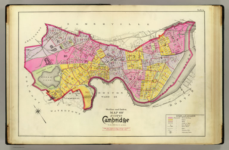
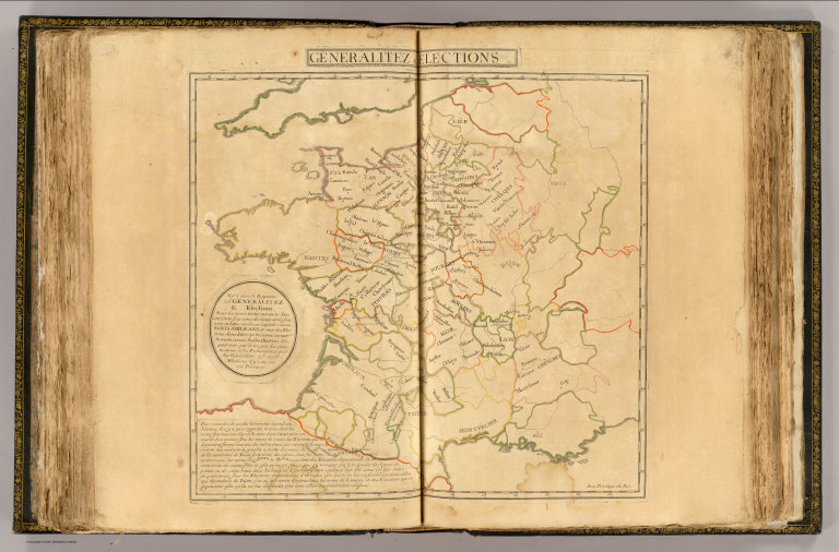
![View: [Subterranean holes near Tilbury]](https://media.davidrumsey.com/MediaManager/srvr?mediafile=/Size3/RUMSEY~8~1/162/104188084.1.jpg)

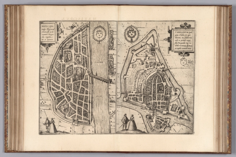
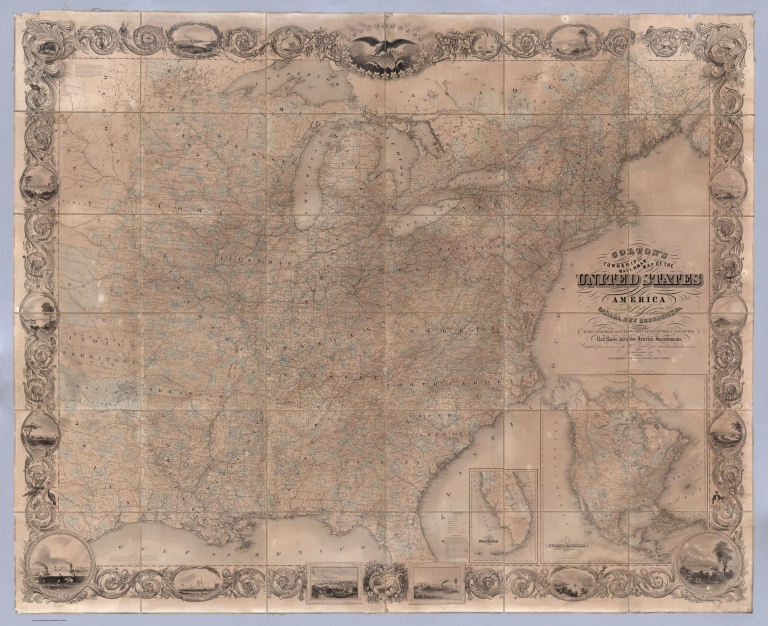
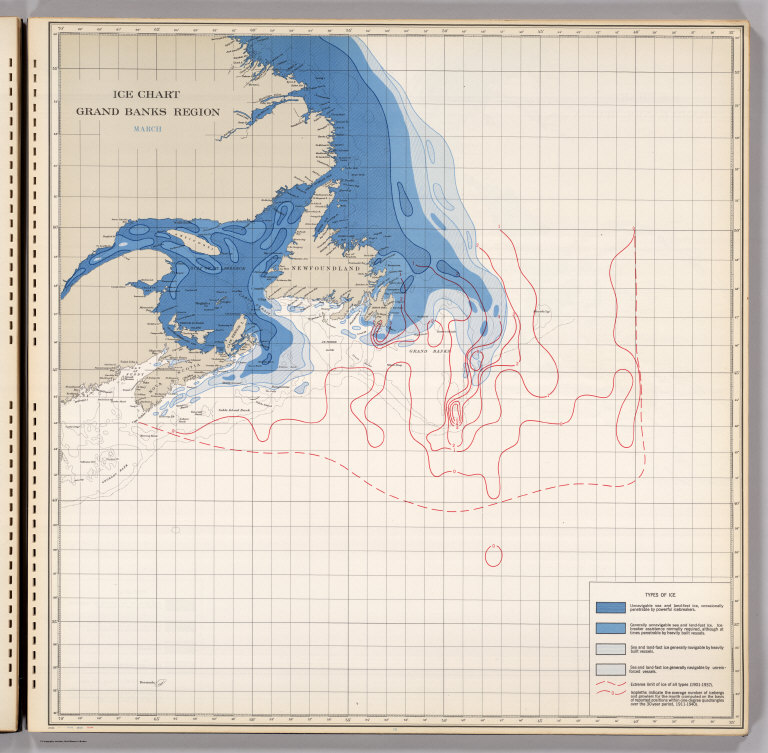
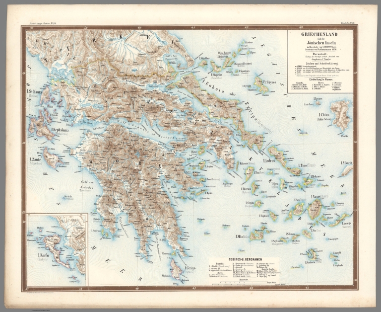
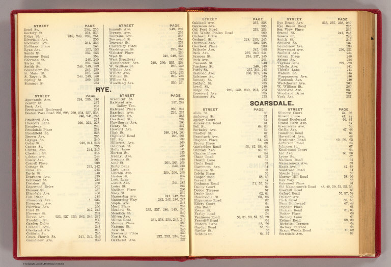


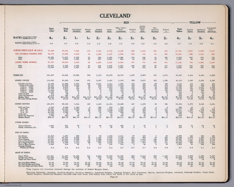


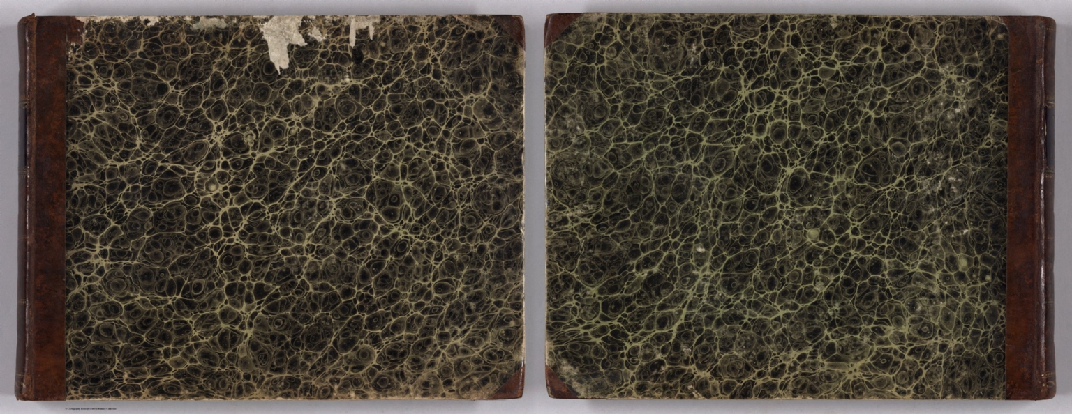
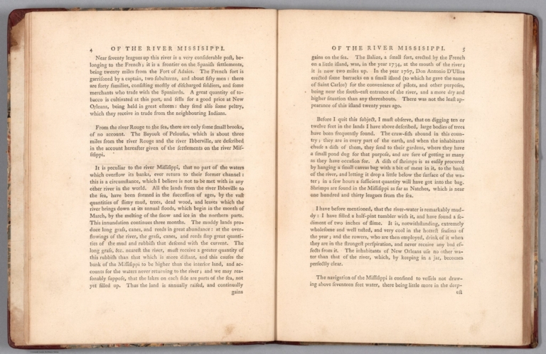
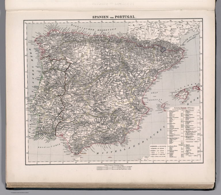
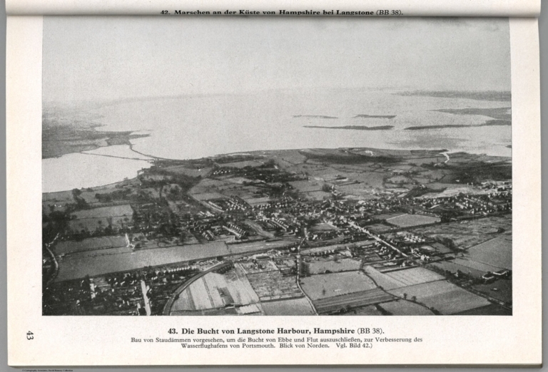
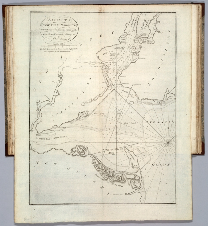

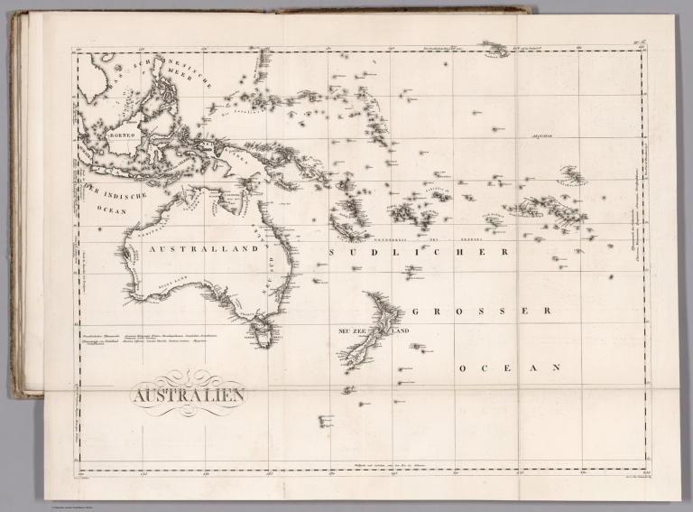


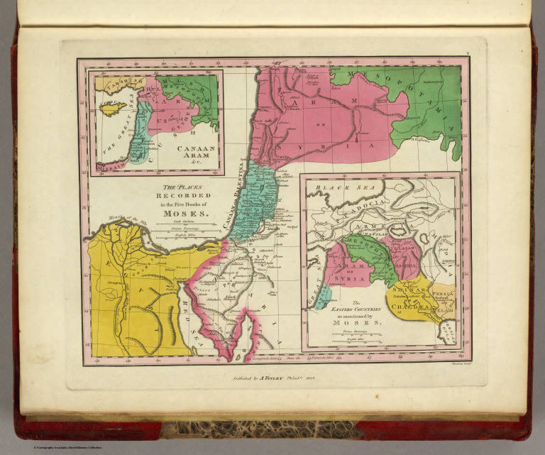

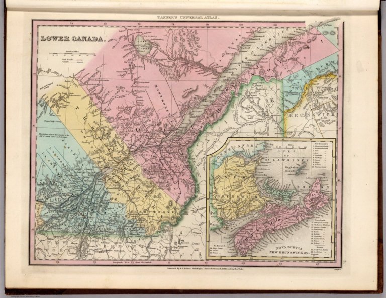
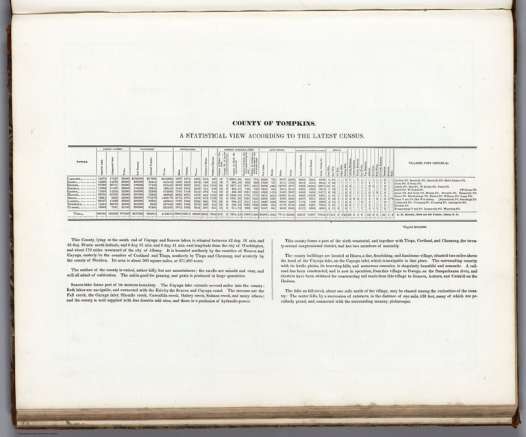

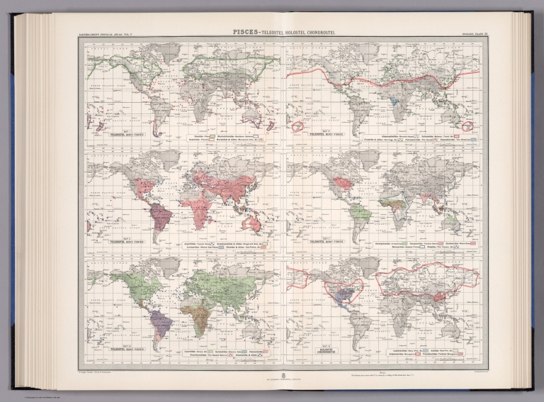
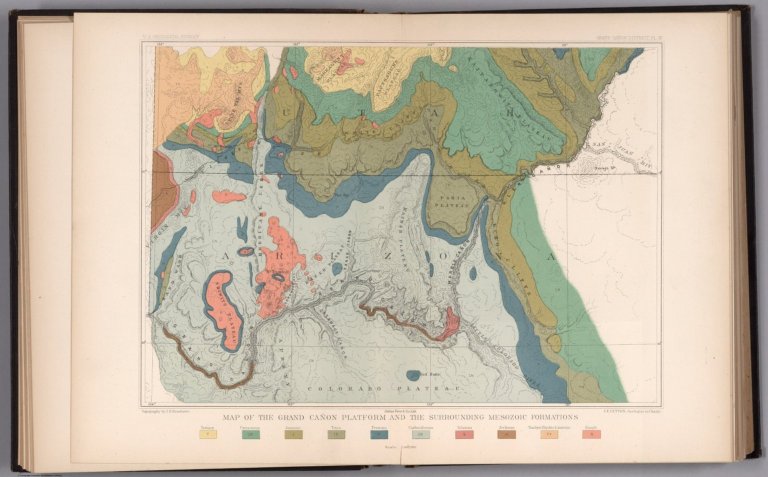

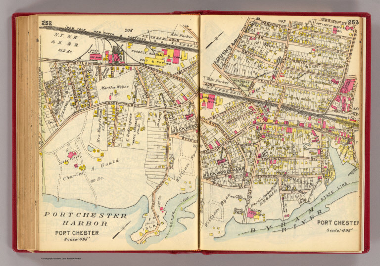
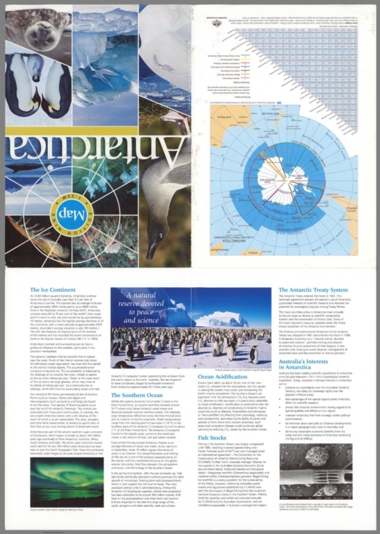
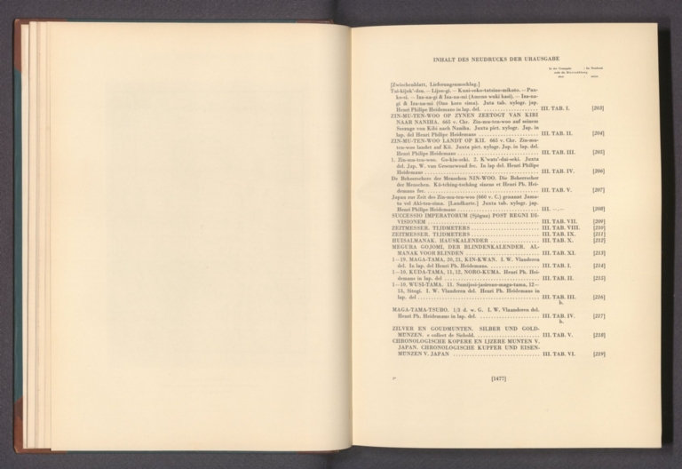
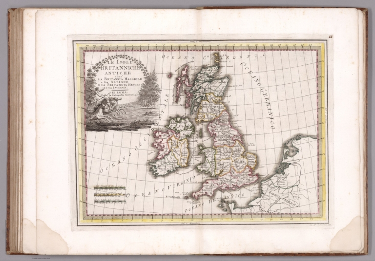

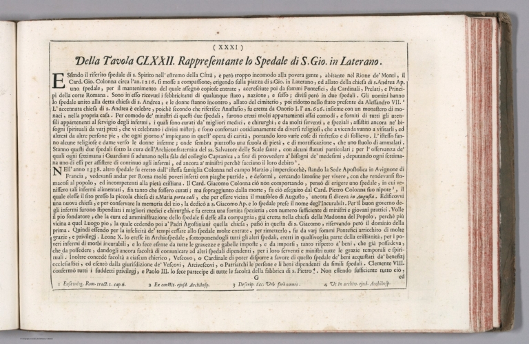
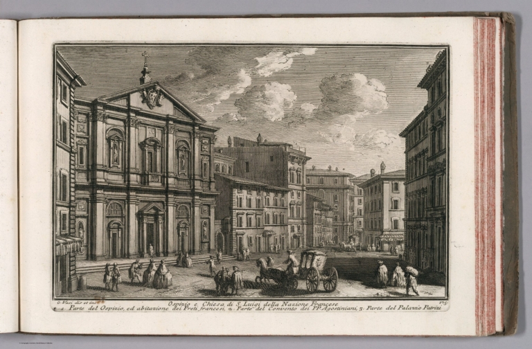
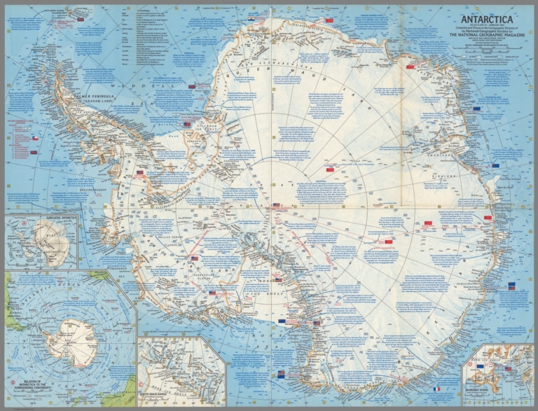
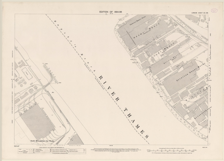


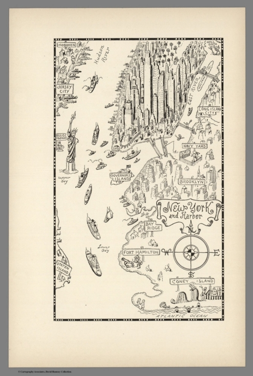


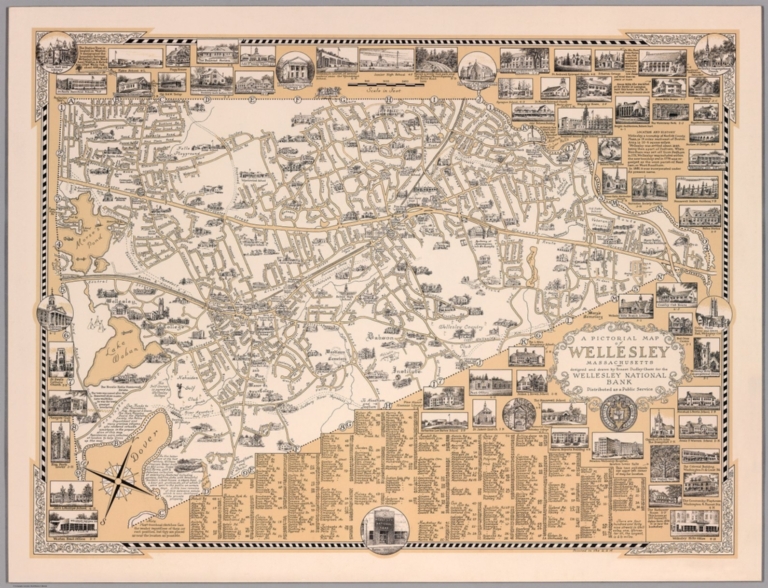
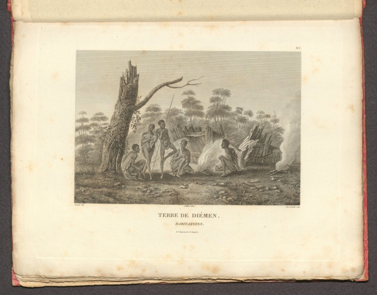
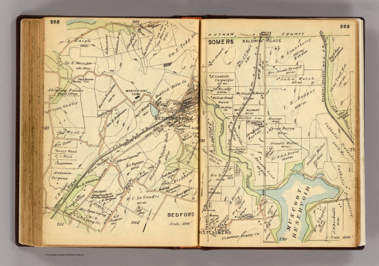


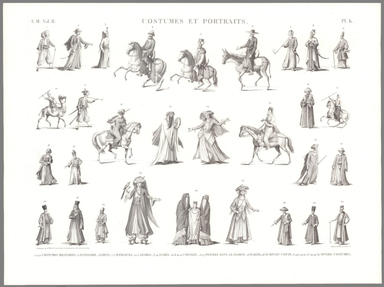
![56. TA EPEIПIA (1). [Burnt villages].](https://media.davidrumsey.com/MediaManager/srvr?mediafile=/Size3/RUMSEY~8~1/195/14295124.jpg)
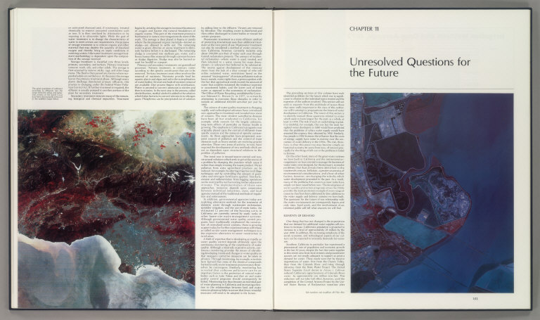
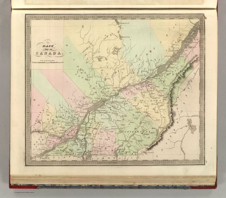
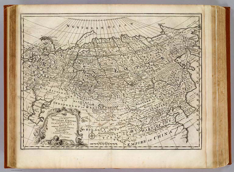


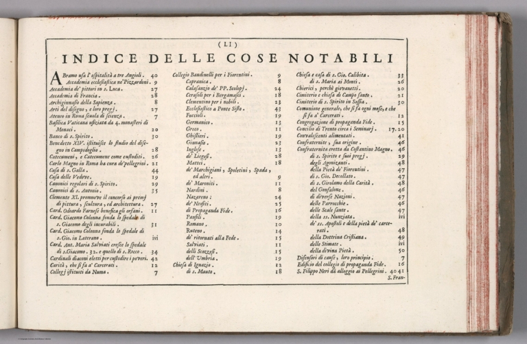
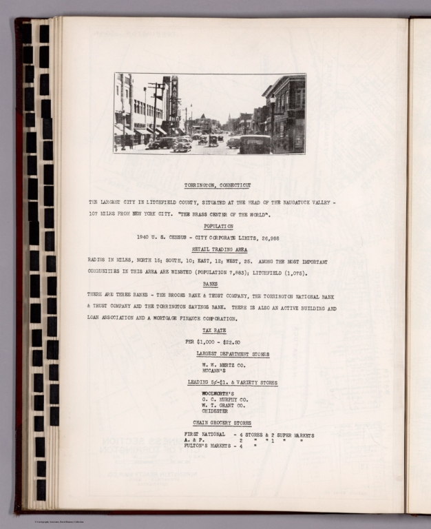
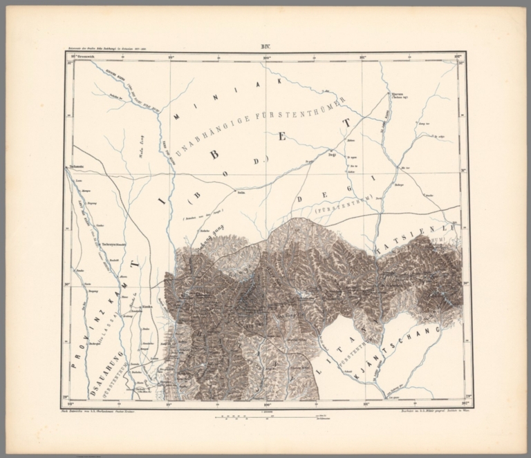

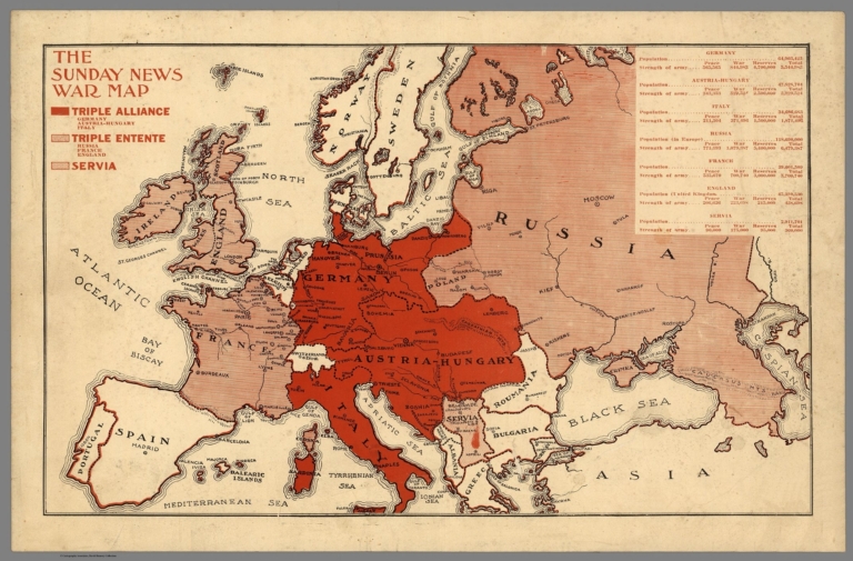

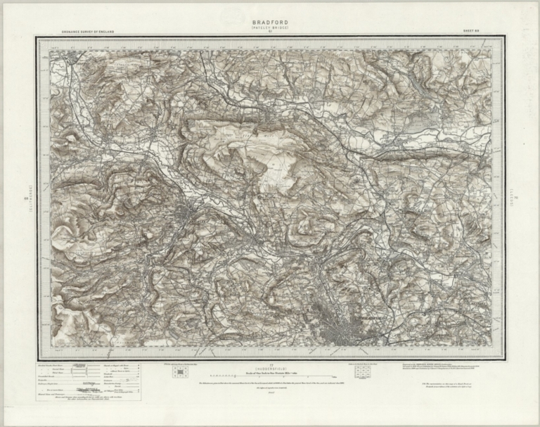
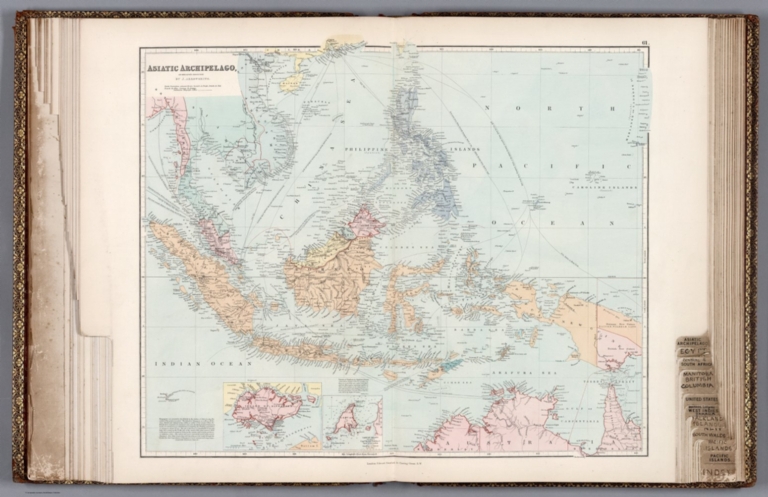
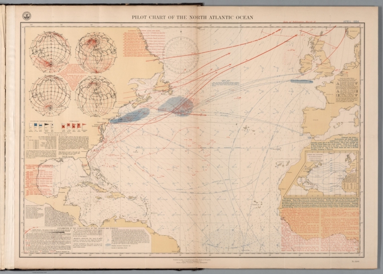
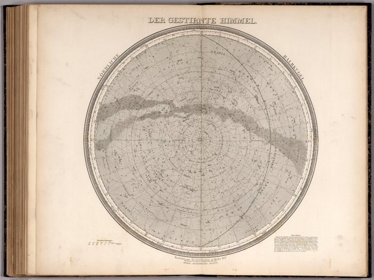
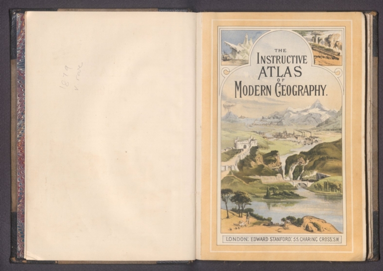
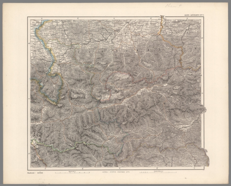
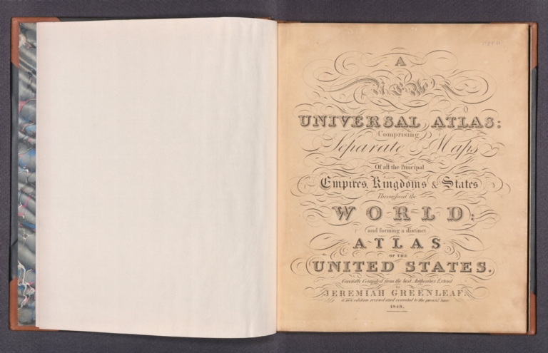
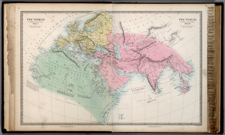
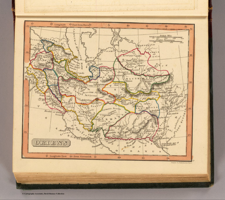
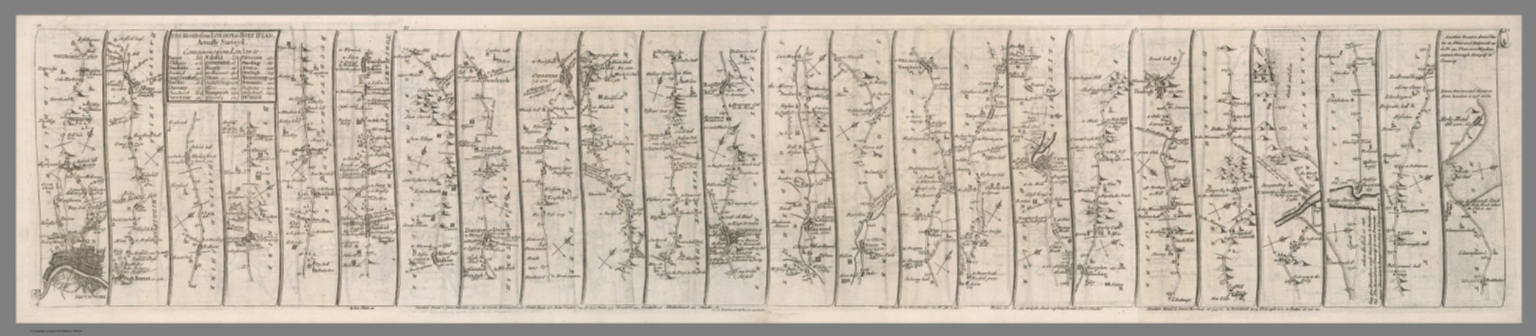
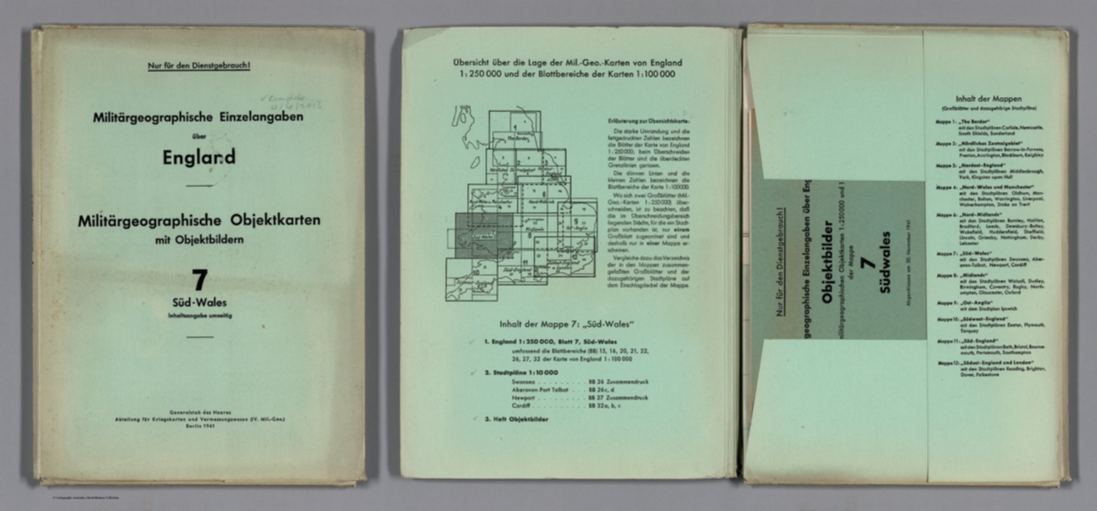
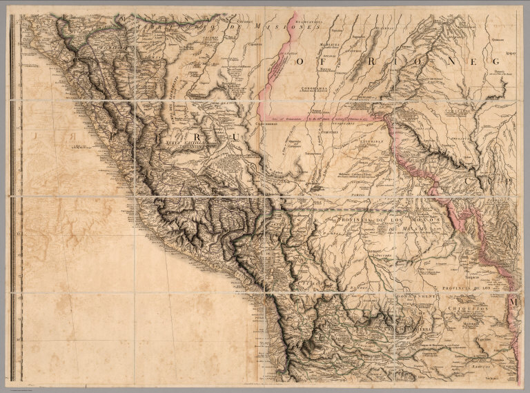


![Text: No. 49.] Tottenham Court Road, Division I (3).](https://media.davidrumsey.com/MediaManager/srvr?mediafile=/Size3/RUMSEY~8~1/179/14002422.jpg)
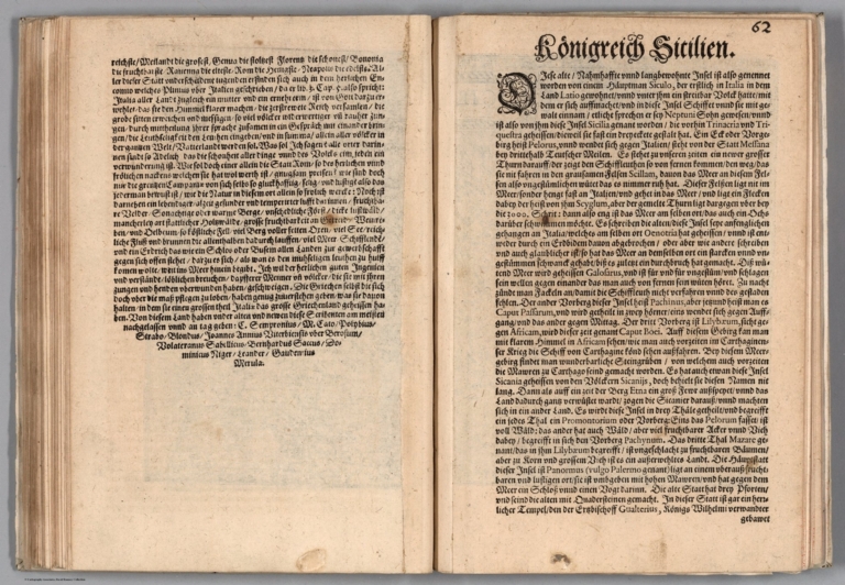
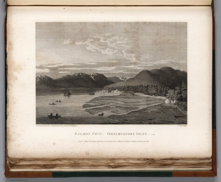
![[B кopнe измeнилacь paбoтa пo экcплoaтaции нeфтя ныx пpoмыcлoв ... ].](https://media.davidrumsey.com/MediaManager/srvr?mediafile=/Size3/RUMSEY~8~1/205/14402053.jpg)
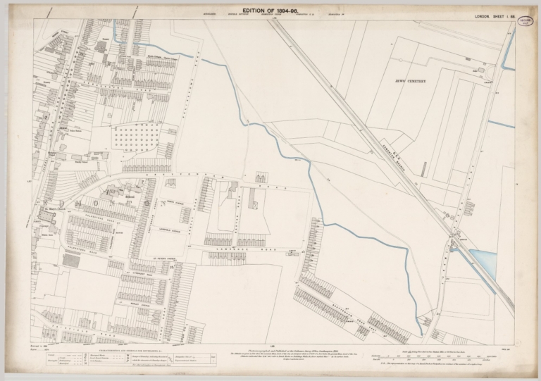

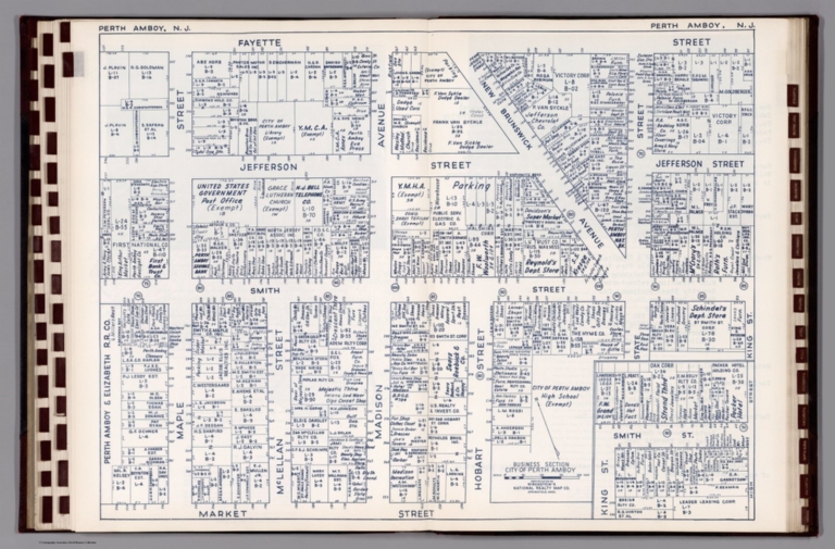

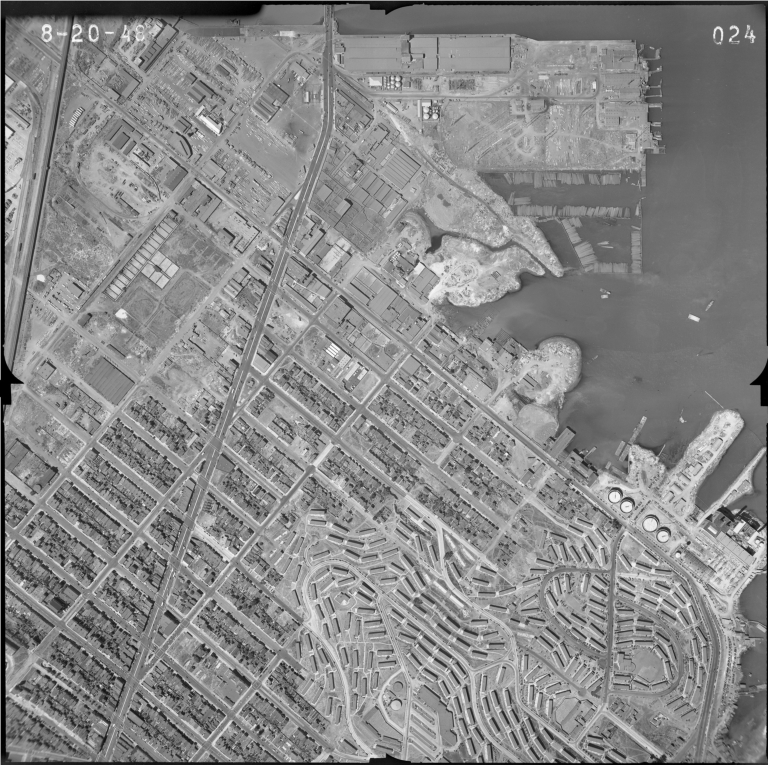


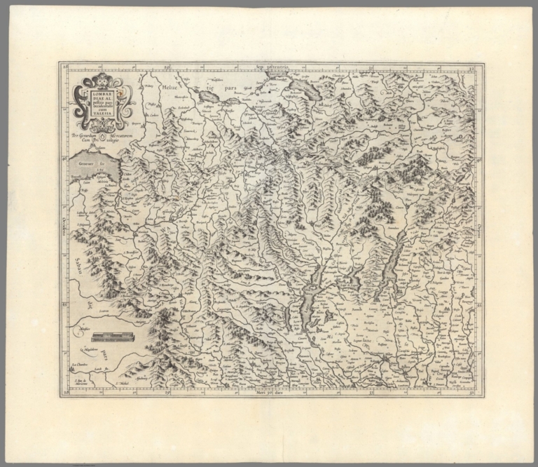
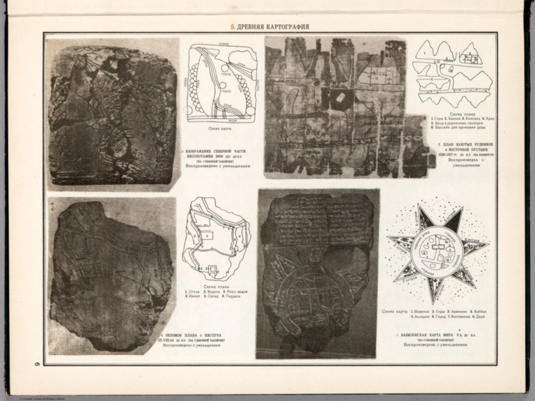
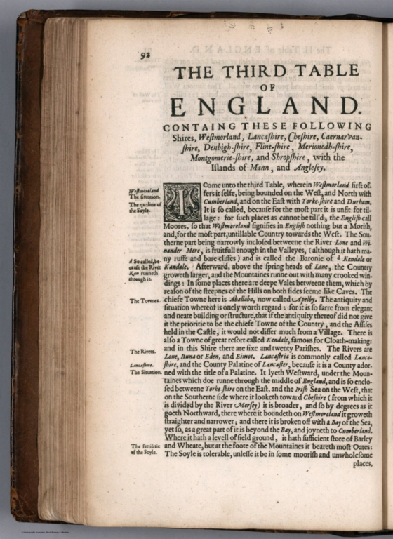
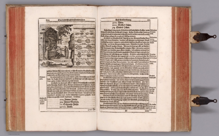

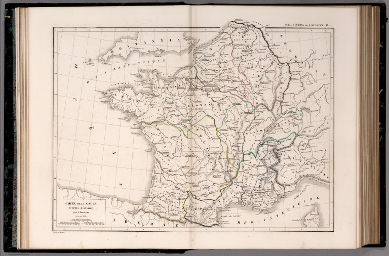
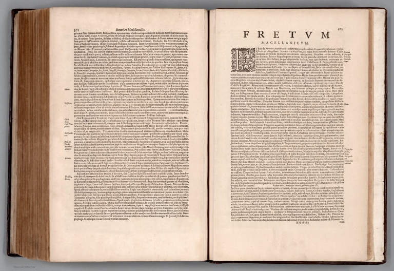
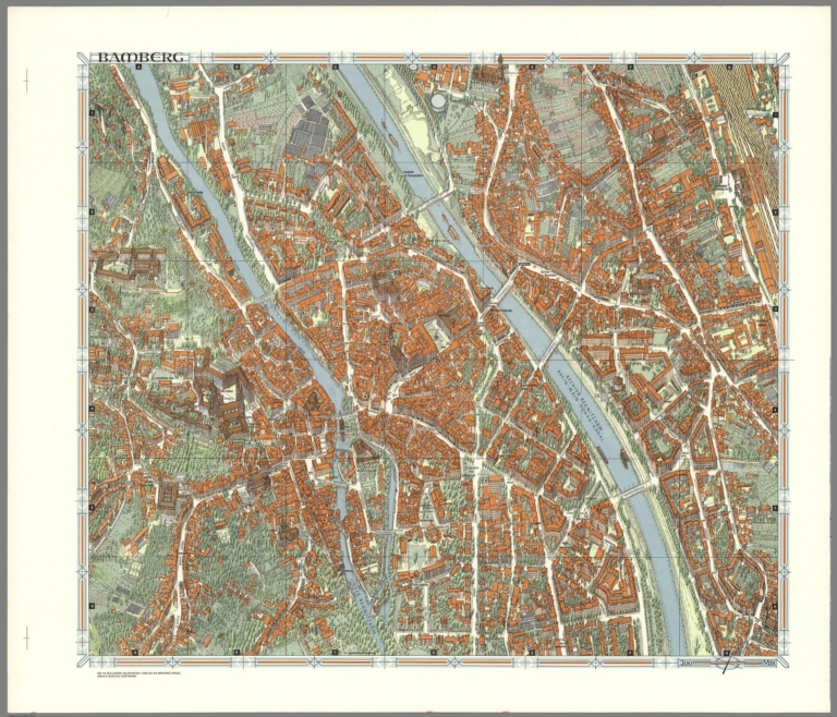
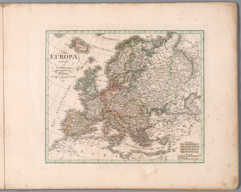

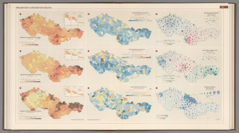
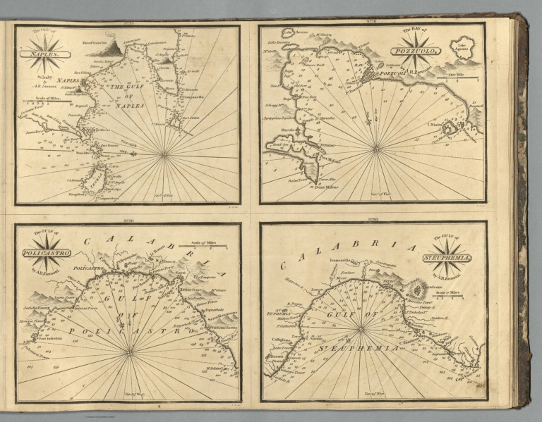
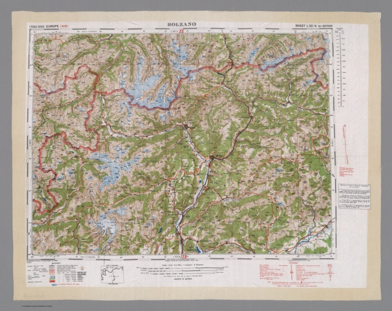
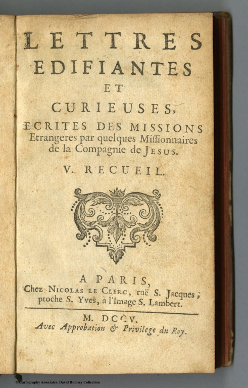


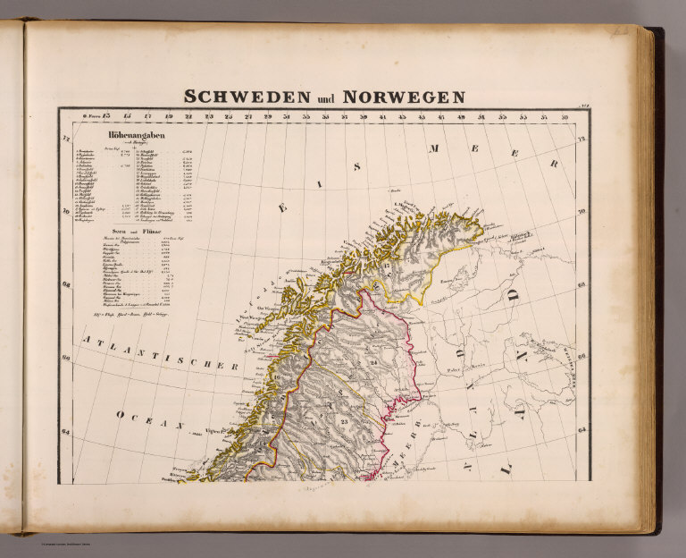
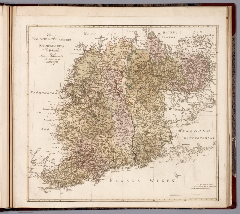
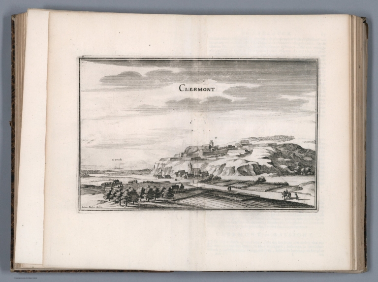
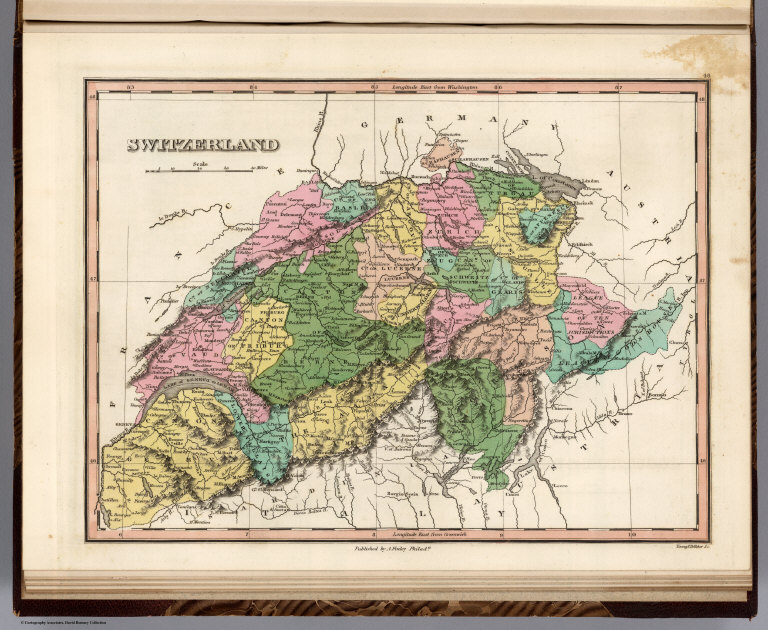

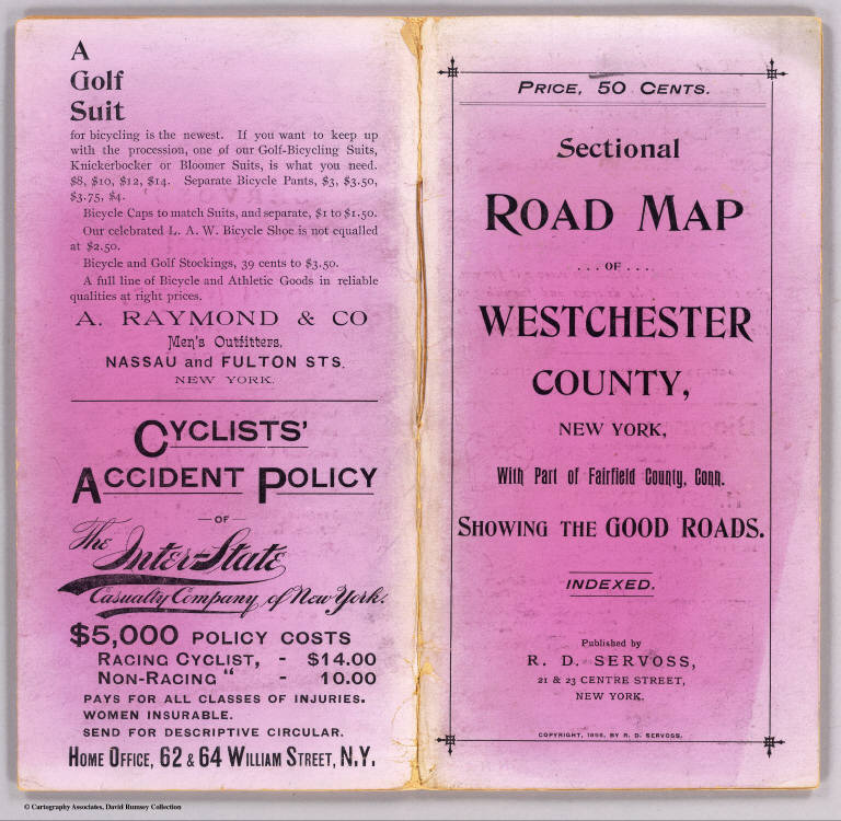
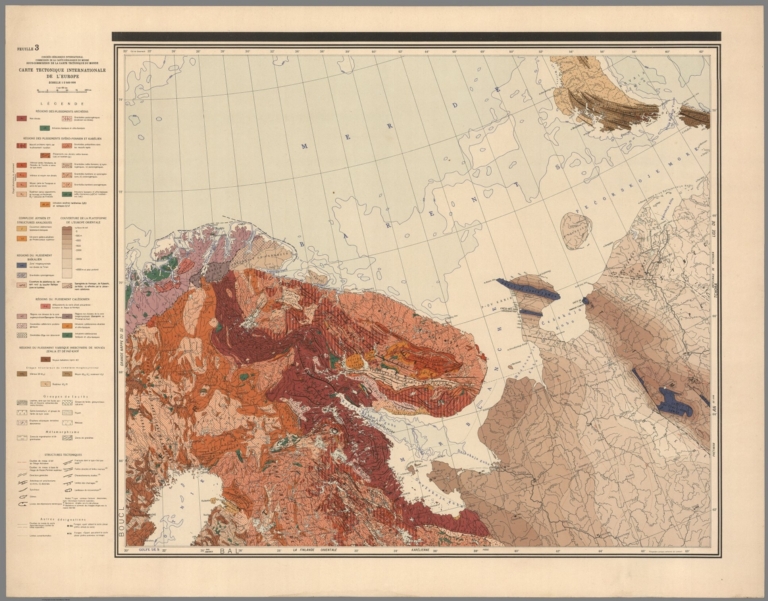
![Text: [Example 24]. (3) ...](https://media.davidrumsey.com/MediaManager/srvr?mediafile=/Size3/RUMSEY~8~1/205/14475043.jpg)
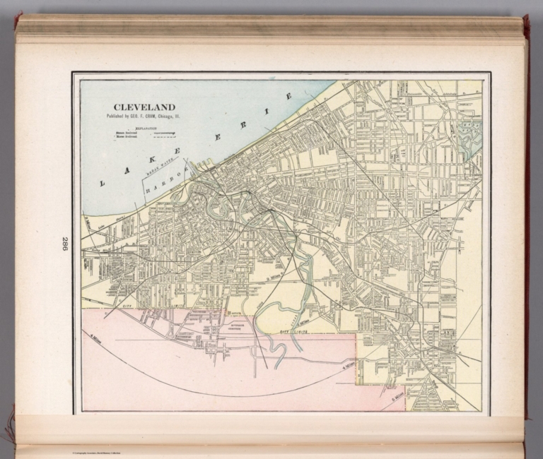
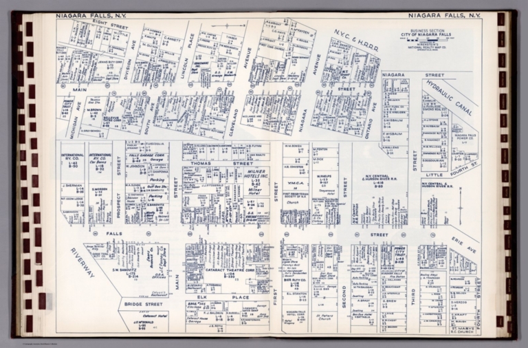
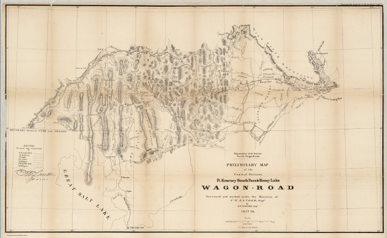
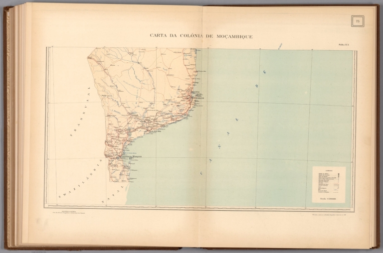
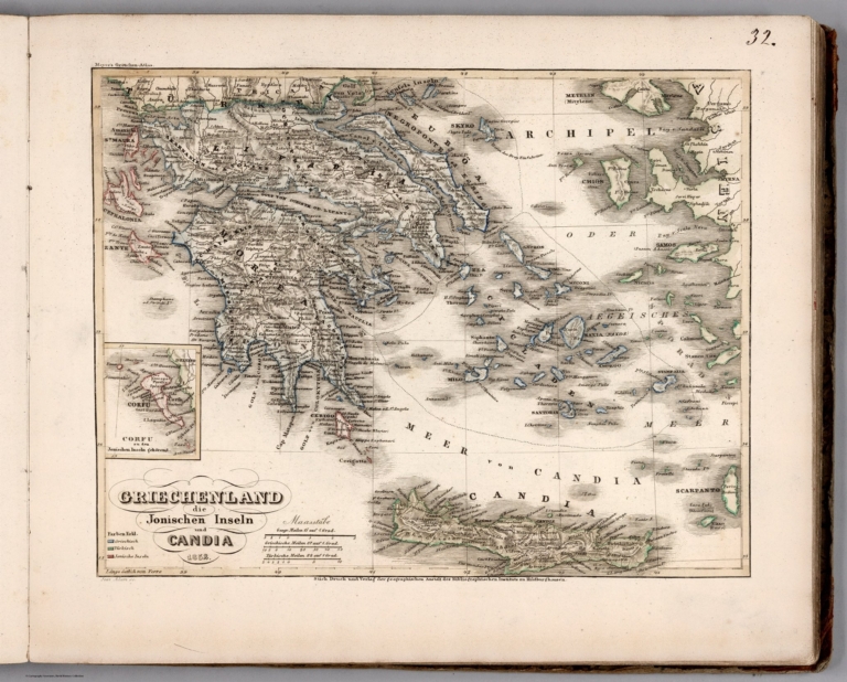
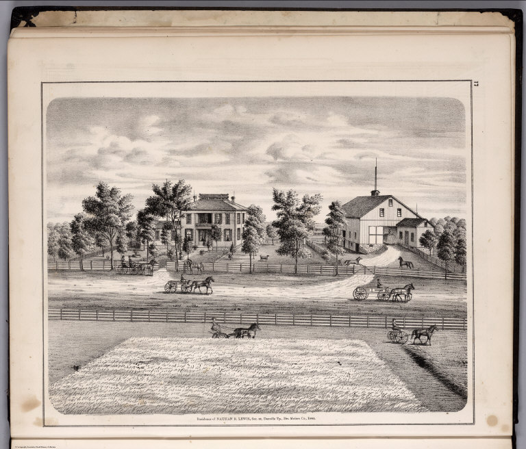
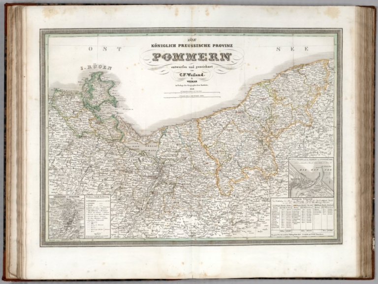
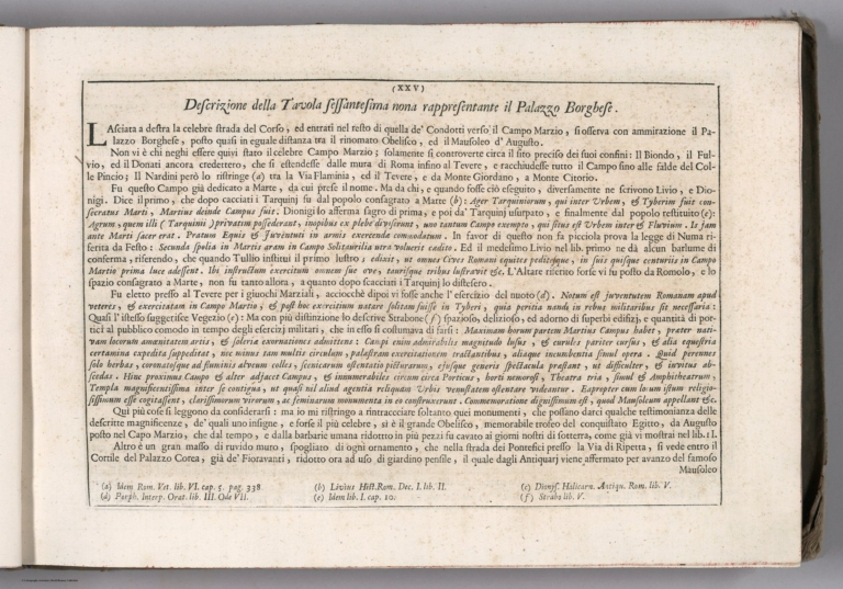
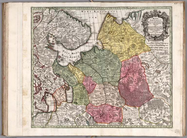
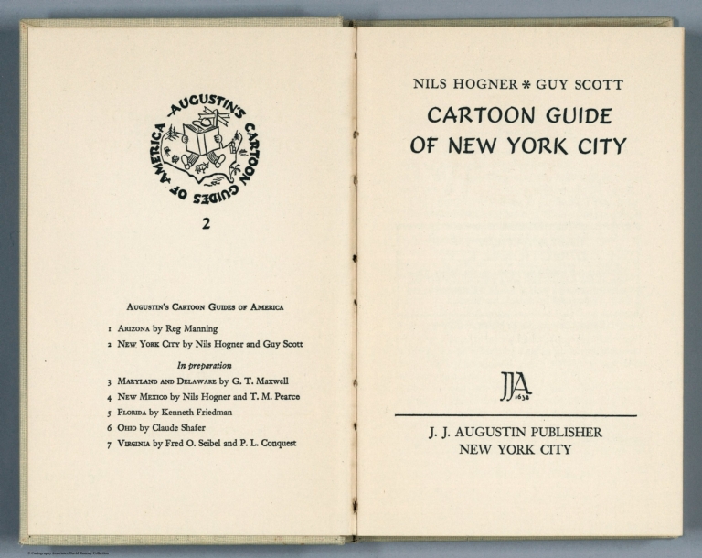

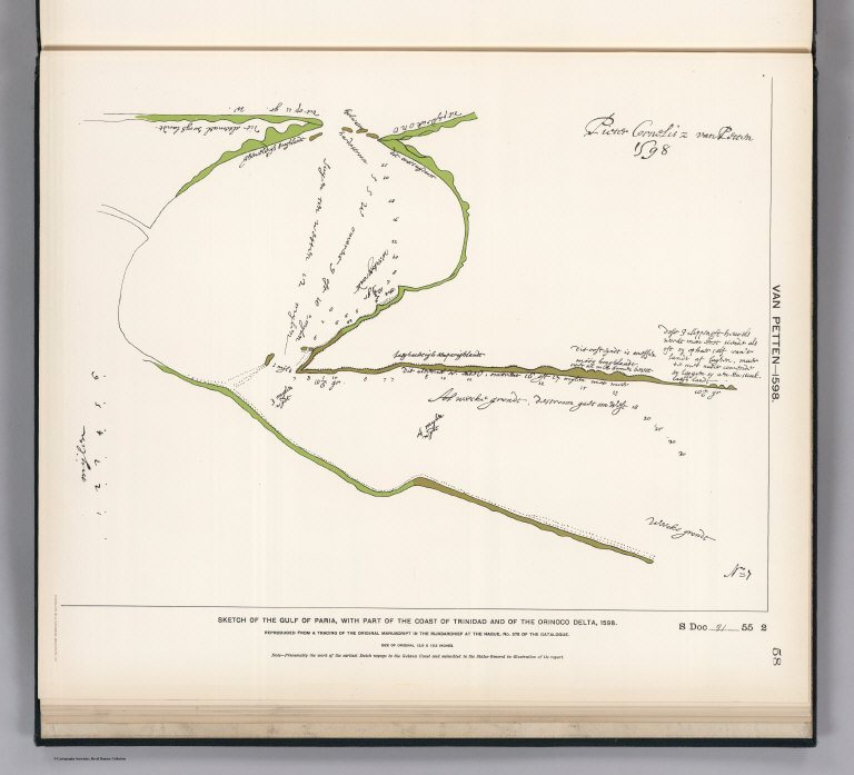
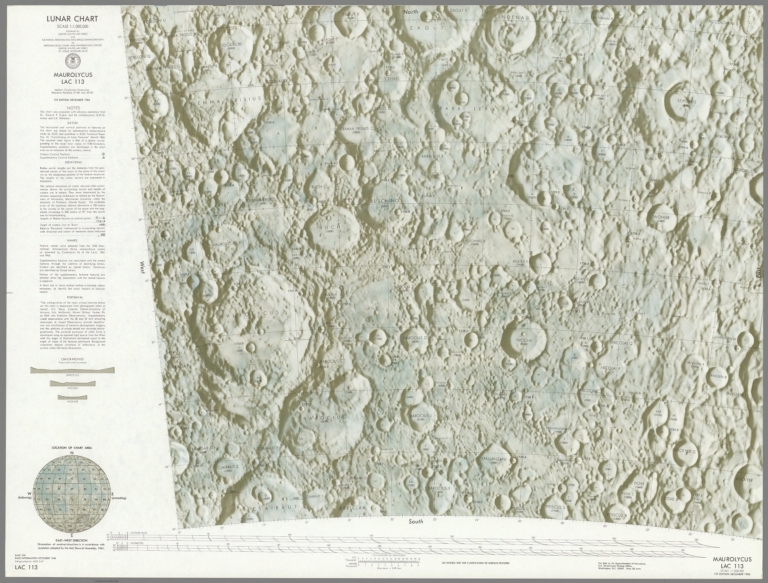
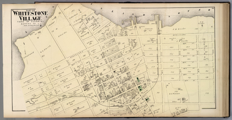
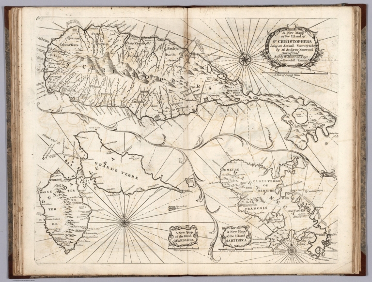


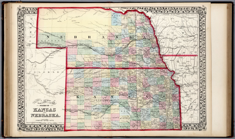
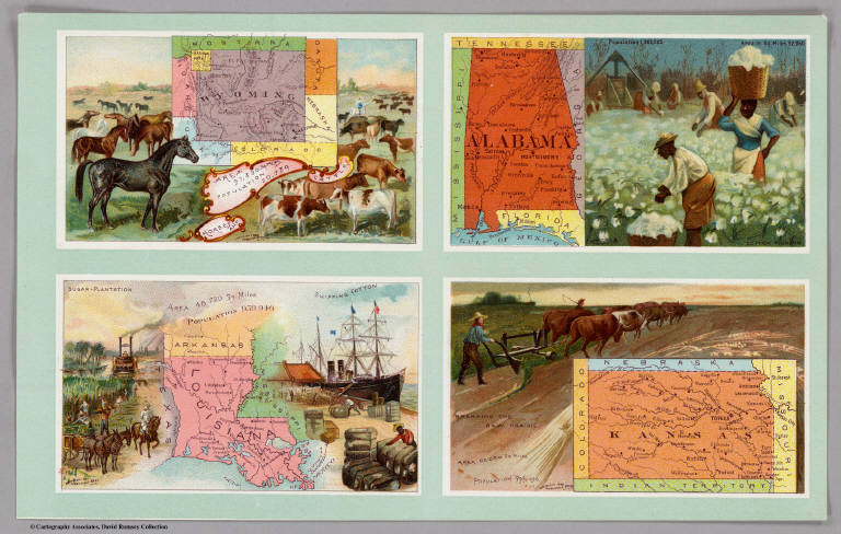
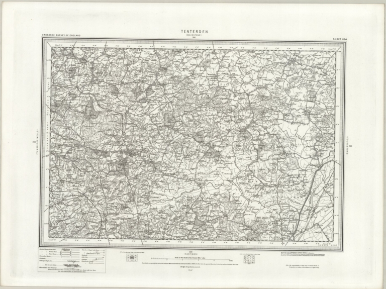
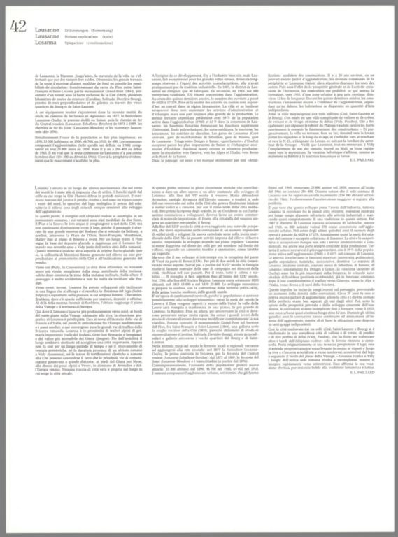
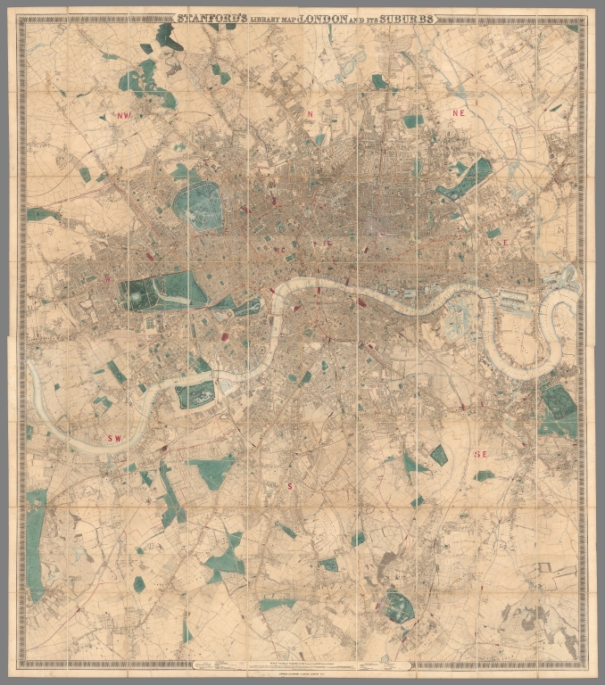
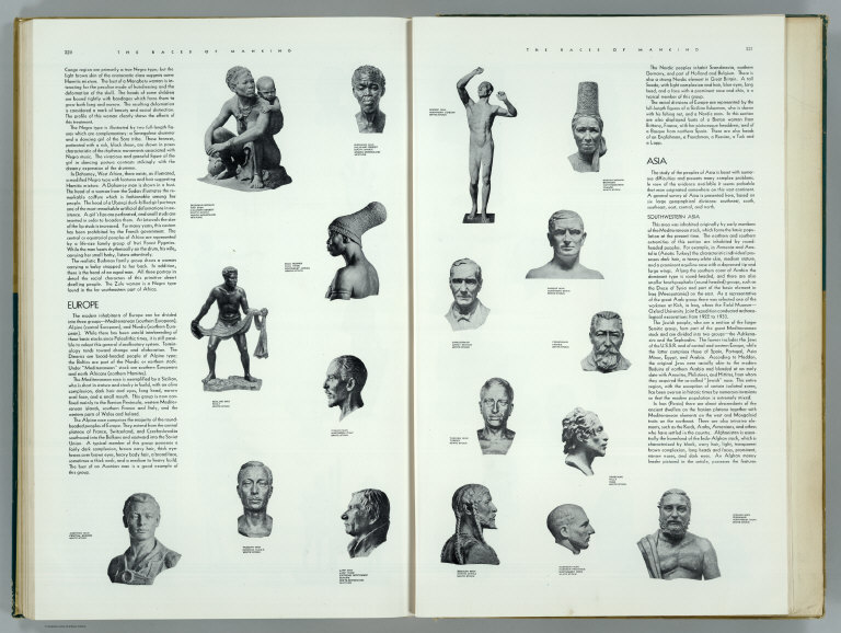
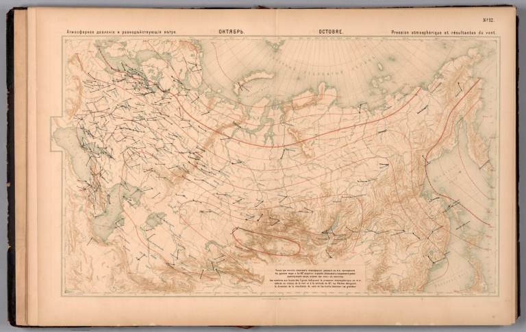


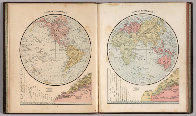

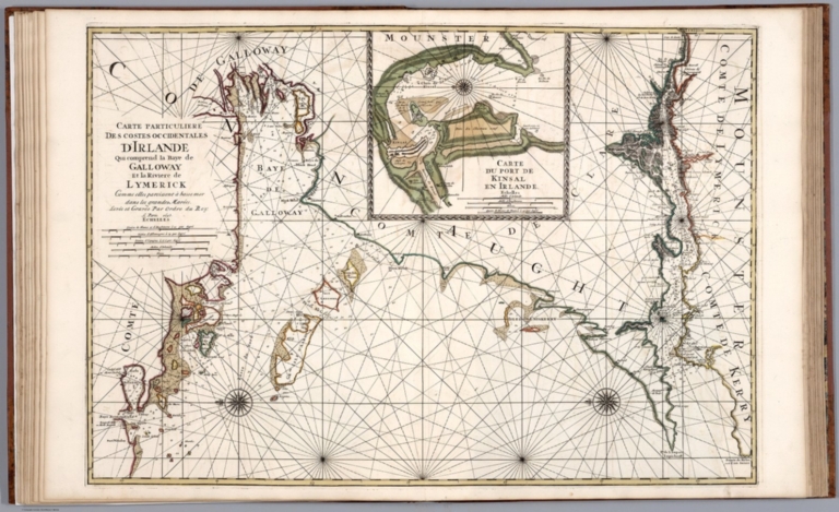
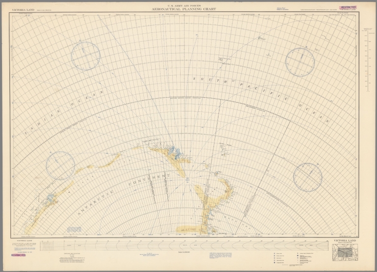
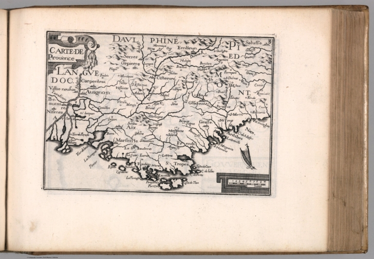
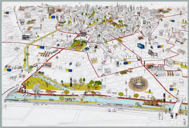

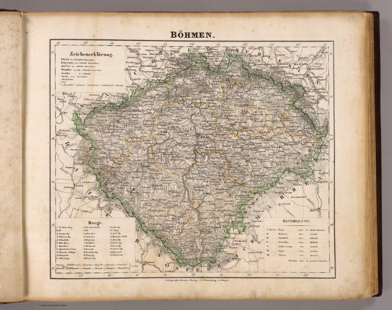
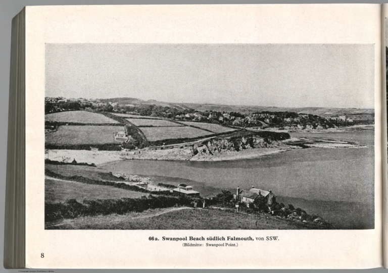
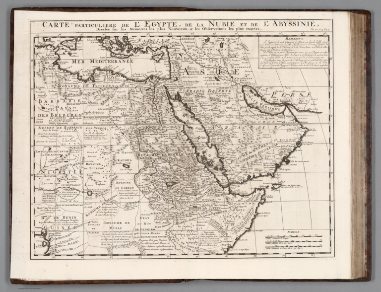
![Text: No. 43.] Skinner-St. and King-St. Snow Hill (1).](https://media.davidrumsey.com/MediaManager/srvr?mediafile=/Size3/RUMSEY~8~1/179/14002367.jpg)