Who What Where WhenWHAT
|
Author
Chesney, Francis Rawson (1789 - 1872)
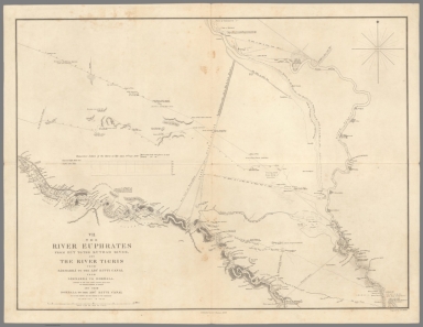
Full Title
II. The River Euphrates from Sumeisat to Kal’at En Nejm.
List No
15662.002
Author
Chesney, Francis Rawson (1789 - 1872)
Full Title
III. The River Euphrates from Kal’at En Nejm to Abu Saide.
List No
15662.003
Author
Chesney, Francis Rawson (1789 - 1872)
Full Title
IV. The River Euphrates from Abu Saide to Werdi.
List No
15662.004
Author
Chesney, Francis Rawson (1789 - 1872)
Full Title
V. The River Euphrates from Werdi to Hit.
List No
15662.005
Author
Chesney, Francis Rawson (1789 - 1872)
Full Title
VI. The River Tigris from Nineveh to Kal’ah Sherkat, and again from Kal’ah Sherkat to Sammarra.
List No
15662.006
Author
Chesney, Francis Rawson (1789 - 1872)
Full Title
VII. The River Euphrates from Hit to the Kuthah River, and River Tigris from Sammarra to the Abu Hitti Canal.
List No
15662.007
Author
Chesney, Francis Rawson (1789 - 1872)
Full Title
VIII. The River Euphrates from the Kuthah River to El Wuja Island, and the River Tigris from the Abu Hitti Canal to Judifah Island.
List No
15662.008
Author
Chesney, Francis Rawson (1789 - 1872)
Full Title
IX. The River Euphrates from El Wuja Island to Ummu-l-Huntah, and the RiverTigris from Judifah Island to Serut Castle.
List No
15662.009
Author
Chesney, Francis Rawson (1789 - 1872)
Full Title
X. The River Euphrates from Ummu-l-Huntah to Kurnali, and the River Tigris from Serut Castle to Kurnah.
List No
15662.010
Author
Chesney, Francis Rawson (1789 - 1872)
Full Title
XI. The River Karun from Shuster to Salmanah Island.
List No
15662.011
Author
Chesney, Francis Rawson (1789 - 1872)
Full Title
XII. The Shatt el’Arab from Basrah to the Bar of the Euphrates, and the River Karun from Salmanah Island to Mohammerah, with the Bah-a-Mishi'r.
List No
15662.012
Author
Chesney, Francis Rawson (1789 - 1872)
Full Title
(Composite map to) (sheets) I-XII
List No
15662.013
Author
Chesney, Francis Rawson (1789 - 1872)
Full Title
(Composite map to) (sheets) I-XII
List No
15662.014
Author
[Mathis, George, Mount Shasta Chambers of Commerce]
Full Title
Sportsland Siskiyou County Top of California Fun Map. Produced by the Weed, Mount Shasta, Dunsmuir Chambers of Commerce.
List No
11901.001
Note
Pictorial bird's eye view map of Mount Shasta at the center on sheet 56x43, folded to 23x10. Covers the area from Shasta Dam and Lake in the south to the Klamath River and Oregon border in the north. Highlighting with humorous pictographs the sporting attractions of the area, including skiing, fishing and hunting. Showing towns, roads, trails, railroads, improved campgrounds, airports, U.S. and state highways, buildings, and landmarks. Relief shown pictorially. Includes George Mathis, Media City logo on lower right corner. Date estimated. On verso includes scenic views with descriptive text and Directory of accommodations.
Author
Mount Shasta Chambers of Commerce
Full Title
Sportsland Siskiyou County Top of California Fun Map. Produced by the Weed, Mount Shasta, Dunsmuir Chambers of Commerce.
List No
11901.001
Note
Pictorial bird's eye view map of Mount Shasta at the center on sheet 56x43, folded to 23x10. Covers the area from Shasta Dam and Lake in the south to the Klamath River and Oregon border in the north. Highlighting with humorous pictographs the sporting attractions of the area, including skiing, fishing and hunting. Showing towns, roads, trails, railroads, improved campgrounds, airports, U.S. and state highways, buildings, and landmarks. Relief shown pictorially. Date estimated. On verso includes scenic views with descriptive text and Directory of accommodations.
Author
[Mathis, George, Mount Shasta Chambers of Commerce]
Full Title
(Text Page to) Sportsland Siskiyou County Top of California Fun Map. Produced by the Weed, Mount Shasta, Dunsmuir Chambers of Commerce.
List No
11901.003
Note
Pictorial bird's eye view map of Mount Shasta at the center on sheet 56x43, folded to 23x10. Covers the area from Shasta Dam and Lake in the south to the Klamath River and Oregon border in the north. Highlighting with humorous pictographs the sporting attractions of the area, including skiing, fishing and hunting. Showing towns, roads, trails, railroads, improved campgrounds, airports, U.S. and state highways, buildings, and landmarks. Relief shown pictorially. Includes George Mathis, Media City logo on lower right corner. Date estimated. On verso includes scenic views with descriptive text and Directory of accommodations.
Author
[Brown, Constance, Widmer, Ted]
Full Title
Lincoln's Odyssey. "to travel sea and land, as fast as wind." Hom Od. 1:99
List No
15608.000
Note
This map was a collaboration between author Ted Widmer and Connie Brown to create map end papers for Widmer's Book "Lincoln on the Verge: Thirteen Days to Washington," published in 2020.
Author
Brown, Constance
Full Title
Martha's Vineyard.
List No
15609.000
Author
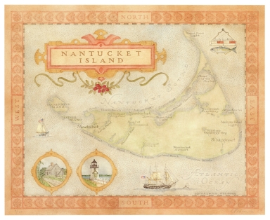
Brown, Constance
Full Title
Nantucket Island.
List No
15610.000
Author
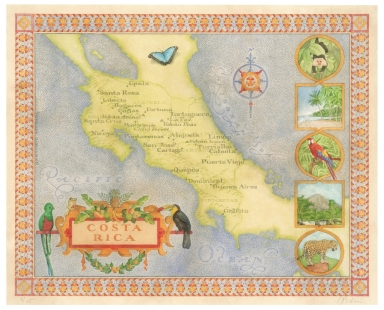
Brown, Constance
Full Title
Costa Rica.
List No
15611.000
Author
Brown, Constance
Full Title
New Haven Apizza.
List No
15612.000
Author
Cram, George Franklin, 1841-1928
Full Title
(Title Page to) Cram's standard American railway system atlas of the world. Accompanied with a complete and simple index of the United States showing the true location of all railroads, towns, villages and post offices ... Maps of the United States are the largest scale and clearest print of any maps published. Foreign maps are compiled largely from charts of the Royal Geographical Society and are geographically correct. Published by Geo. F. Cram, 89 Fulton Street, New York; 61-63 Plymouth Place, Chicago, 1899.
List No
14372.002
Note
Title page to Cram's standard American railway system atlas. Includes extended description of maps, as well as imprint. (Page number inferred.)
Author
Cram, George Franklin, 1841-1928
Full Title
(Contents to) Table of contents.
List No
14372.003
Note
Table of contents to Cram's standard American railway system atlas. Lists place names - "Divisions" - with associated page numbers. With note. (Page number inferred.)
Author
Cram, George Franklin, 1841-1928
Full Title
(Composite Map to) New York : Western half. -- New York : Eastern half. 1899, by Geo. F. Cram.
List No
14372.022
Note
Composite map of New York (western and eastern halves). Shows political boundaries, counties, towns, railroads, steamship lines, topography, bodies of water, drainage, coastlines and islands. Relief shown with hachures. Includes keys with explanations, latitudinal and longitudinal lines, as well as bar scales given in miles. With alphanumeric grid corresponding to "Index of New York" on pages 27-29, 32-35, 38-41 and 44. Colored lithograph. Together, maps are 56 x 80 cm, on two double sheets 67 x 90 cm. "Index of maps" and "Index of cities" in margins, providing navigation for atlas as a whole.
Author
Cram, George Franklin, 1841-1928
Full Title
(Composite Map to) Western half of Pennsylvania. -- Eastern half of Pennsylvania. 1899, by Geo. F. Cram.
List No
14372.036
Note
Composite map of Pennsylvania (western and eastern halves). Shows political boundaries, counties, towns, railroads, steamship lines, topography, bodies of water, drainage, coastlines and islands. Relief shown with hachures. Includes keys with explanations, latitudinal and longitudinal lines, as well as bar scales given in miles. With alphanumeric grid corresponding to "Index of Pennsylvania" on pages 45-55, 58-61 and 64-67. Colored lithograph. Together, maps are 54 x 85 cm, on two double sheets 67 x 90 cm. "Index of maps" and "Index of cities" in margins, providing navigation for atlas as a whole.
Author
Cram, George Franklin, 1841-1928
Full Title
(Composite Map to) Western half of Virginia and West Virginia. -- Eastern half of Virginia and West Virginia. 1899, by Geo. F. Cram.
List No
14372.056
Note
Composite map of Virginia and West Virginia (western and eastern halves). Shows political boundaries, counties, towns, railroads, steamship lines, topography, bodies of water, drainage, coastlines and islands. Relief shown with hachures. Includes keys with explanations, latitudinal and longitudinal lines, as well as bar scales given in miles. With alphanumeric grid corresponding to "Index of Virginia" on pages 85-93 and 96-98, and "Index of West Virginia" on pages 99, 102-105 and 108-110. Colored lithograph. Together, maps are 55 x 85 cm, on two double sheets 67 x 90 cm. "Index of maps" and "Index of cities" in margins, providing navigation for atlas as a whole.
Author
Cram, George Franklin, 1841-1928
Full Title
(Composite Map to) Ohio : North half. -- Ohio : [South half]. 1899, by Geo. F. Cram.
List No
14372.067
Note
Composite map of Ohio (northern and southern halves). Shows political boundaries, counties, towns, railroads, steamship lines, topography, bodies of water, drainage, coastlines and islands. Relief shown with hachures. Includes keys with explanations, latitudinal and longitudinal lines, as well as bar scales given in miles. With alphanumeric grid corresponding to "Index of Ohio" on pages 111-113, 116-119, 122-125 and 128. Colored lithograph. Together, maps are 80 x 55 cm, on two double sheets 90 x 67 cm. "Index of maps" and "Index of cities" in margins, providing navigation for atlas as a whole.
Author
Cram, George Franklin, 1841-1928
Full Title
Michigan. 1899, by Geo. F. Cram.
List No
14372.076
Note
Map of Michigan. Shows political boundaries, counties, towns, railroads, steamship lines, topography, bodies of water, drainage, coastlines and islands. Relief shown with hachures. Includes key with explanation, latitudinal and longitudinal lines, as well as a bar scale given in miles. Two inset maps: Lake Superior -- L. Superior. With alphanumeric grid corresponding to "Index of Michigan" on pages 129-137 and 140. Colored lithograph. Map is 55 x 40 cm, on double sheet 67 x 45 cm. "Index of maps" and "Index of cities" in margins, providing navigation for atlas as a whole.
Author
Cram, George Franklin, 1841-1928
Full Title
Colorado. 1899, by Geo. F. Cram.
List No
14372.114
Note
Map of Colorado. Shows political boundaries, counties, towns, railroads, topography, bodies of water, drainage, coastlines and islands. Relief shown with hachures. Includes key with explanation, latitudinal and longitudinal lines, as well as a bar scale given in miles. With alphanumeric grid corresponding to "Index of Colorado" on pages 208-211 and 214-215. Colored lithograph. Map is 40 x 55 cm, on double sheet 45 x 67 cm. "Index of maps" and "Index of cities" in margins, providing navigation for atlas as a whole.
Author
Cram, George Franklin, 1841-1928
Full Title
Minnesota. 1899, by Geo. F. Cram.
List No
14372.124
Note
Map of Minnesota. Shows political boundaries, counties, towns, railroads, steamship lines, topography, bodies of water, drainage, coastlines and islands. Relief shown with hachures. Includes key with explanation, latitudinal and longitudinal lines, as well as a bar scale given in miles. Inset map: St. Paul and Minneapolis. With alphanumeric grid corresponding to "Index of Minnesota" on pages 226-231 and 234. Colored lithograph. Map, divided into two parts, is 55 x 40 cm, on double sheet 67 x 45 cm. "Index of maps" and "Index of cities" in margins, providing navigation for atlas as a whole.
Author
Cram, George Franklin, 1841-1928
Full Title
(Composite Map to) Western half of Texas. -- Eastern half of Texas. 1899, by Geo. F. Cram.
List No
14372.187
Note
Composite map of Texas (western and eastern halves). Shows political boundaries, counties, towns, railroads, steamship lines, topography, bodies of water, drainage, coastlines and islands. Relief shown with hachures. Includes keys with explanations, latitudinal and longitudinal lines, as well as bar scales given in miles. With alphanumeric grid corresponding to "Index of Texas" on pages 341, 344-347, 350-353 and 356. Colored lithograph. Together, map is 57 x 81 cm, on two double sheets 67 x 90 cm. "Index of maps" and "Index of cities" in margins, providing navigation for atlas as a whole.
Author
Cram, George Franklin, 1841-1928
Full Title
Oklahoma and Indianters. 1899, by Geo. F. Cram.
List No
14372.193
Note
Map of Oklahoma and Indiana. Shows political boundaries, counties, towns, railroads, topography, bodies of water, drainage, coastlines and islands. Relief shown with hachures. Includes key with explanation, latitudinal and longitudinal lines, as well as a bar scale given in miles. With alphanumeric grid corresponding to "Index of Indian Territory" on pages 357-358; "Index of Oklahoma Territory" on pages 359 and 362. Colored lithograph. Map, divided into two parts, is 40 x 57 cm, on double sheet 45 x 67 cm. "Index of maps" and "Index of cities" in margins, providing navigation for atlas as a whole.
Author
Cram, George Franklin, 1841-1928
Full Title
San Francisco.
List No
14372.198
Note
Map of San Francisco, California. Shows railroads, streets, parks, hills, bodies of water, drainage, coastlines and islands. Includes key with explanation. With alphanumeric grid corresponding to "Reference to figures" at top. Colored lithograph. Map is 28 x 28 cm, on sheet 45 x 33 cm.
Author
Cram, George Franklin, 1841-1928
Full Title
Nevada. 1899, by Geo. F. Cram.
List No
14372.200
Note
Map of Nevada. Shows political boundaries, counties, towns, railroads, topography, bodies of water, drainage, coastlines and islands. Relief shown with hachures. Includes key with explanation, latitudinal and longitudinal lines, as well as a bar scale given in miles. With alphanumeric grid corresponding to "Index of Nevada" on page 371. Colored lithograph. Map is 55 x 39 cm, on double sheet 67 x 45 cm. "Index of maps" and "Index of cities" in margins, providing navigation for atlas as a whole.
Author
Cram, George Franklin, 1841-1928
Full Title
(Composite Map to) California and Nevada : Northern half. -- California and Nevada : Southern half. 1899, by Geo. F. Cram.
List No
14372.205
Note
Composite map of California and Nevada (northern and southern halves). Shows political boundaries, counties, towns, railroads, topography, bodies of water, drainage, coastlines and islands. Relief shown with hachures. Includes keys with explanations, latitudinal and longitudinal lines, as well as bar scales given in miles. With alphanumeric grid corresponding to "Index of Nevada" on page 371; "Index of California" on pages 374-375, 378-379 and 382. Colored lithograph. Together, maps are 82 x 57 cm, on two double sheets 90 x 67 cm. "Index of maps" and "Index of cities" in margins, providing navigation for atlas as a whole.
Author
Cram, George Franklin, 1841-1928
Full Title
Montana. 1899, by Geo. F. Cram.
List No
14372.211
Note
Map of Montana. Shows political boundaries, counties, towns, railroads, topography, bodies of water, drainage, coastlines and islands. Relief shown with hachures. Includes key with explanation, latitudinal and longitudinal lines, as well as a bar scale given in miles. With alphanumeric grid corresponding to "Index of Montana" on pages 387 and 390. Colored lithograph. Map is 40 x 56 cm, on double sheet 45 x 67 cm. "Index of maps" and "Index of cities" in margins, providing navigation for atlas as a whole.
Author
Cram, George Franklin, 1841-1928
Full Title
(Index Page to) Index to state map of Wyoming. (2) -- Yellowstone National Park, Wyoming. 1899, by Geo. F. Cram.
List No
14372.216
Note
Index to the map of Wyoming on preceding pages, 396-397. Lists railroads, counties and towns (including population) in alphabetical order, with associated alphanumeric coordinate points from grid on map. Includes explanation. Index on pages 395 and 398. Also, map of Yellowstone National Park, Wyoming. Shows political boundaries, topography, plateaus, canyons, basins, bodies of water, hot springs, geysers, drainage, shorelines and islands. Relief shown with hachures. Includes latitudinal and longitudinal lines, as well as a bar scale given in miles. With alphanumeric grid corresponding to "Index of Wyoming" above map and preceding on page 395. Colored lithograph. Map is 26 x 23 cm, on sheet 45 x 33 cm.
Author
Cram, George Franklin, 1841-1928
Full Title
(Composite Map to) Western part of Washington. -- Eastern part of Washington. 1899, by Geo. F. Cram.
List No
14372.223
Note
Composite map of Washington (western and eastern halves). Shows political boundaries, counties, towns, Indian reservations, mines, railroads, topography, bodies of water, drainage, coastlines and islands. Relief shown with hachures. Includes keys with explanations, latitudinal and longitudinal lines, as well as bar scales given in miles. With alphanumeric grid corresponding to "Index of Washington" on pages 403 and 406-407. Colored lithograph. Together, map is 55 x 80 cm, on two double sheets 67 x 90 cm. "Index of maps" and "Index of cities" in margins, providing navigation for atlas as a whole.
Author
Cram, George Franklin, 1841-1928
Full Title
Boston.
List No
14372.227
Note
Map of Boston, Massachusetts. Shows political boundaries, railroads, streets, parks, bodies of water, drainage, shoreline and islands. Includes a bar scale given in miles and compass rose with north oriented toward upper left. Map indexed to indicate businesses, churches and theaters, etc. Colored lithograph. Map is 31 x 24 cm, on sheet 45 x 33 cm.
Author
Cram, George Franklin, 1841-1928
Full Title
Alaska. 1899, by Geo. F. Cram.
List No
14372.238
Note
Map of Alaska. Shows political boundaries, districts, towns, railroads, topography, glaciers, bodies of water, drainage, coastlines and islands. Relief shown with hachures. Includes key with explanation, latitudinal and longitudinal lines, as well as a bar scale given in miles. Three inset maps: Cook Inlet -- Yukon River -- Klondike District. With alphanumeric grid corresponding to "Index of Alaska" on page 427. Colored lithograph. Map is 40 x 56 cm, on double sheet 45 x 67 cm. "Index of maps" and "Index of cities" in margins, providing navigation for atlas as a whole.
Author
Cram, George Franklin, 1841-1928
Full Title
(Composite Map to) Western half of Nova Scotia. -- Eastern half of Nova Scotia. 1899, by Geo. F. Cram.
List No
14372.247
Note
Composite map of Nova Scotia, Canada (western and eastern halves). Shows political boundaries, counties, towns, railroads, topography, bodies of water, drainage, coastlines and islands. Relief shown with hachures. Includes keys with explanations, latitudinal and longitudinal lines, as well as bar scales given in miles. With alphanumeric grid corresponding to "Index of Nova Scotia" on pages 435 and 438-439. Colored lithograph. Together, map is 55 x 80 cm, on double sheet 67 x 90 cm. "Index of maps" and "Index of cities" in margins, providing navigation for atlas as a whole.
Author
Cram, George Franklin, 1841-1928
Full Title
Richmond and Manchester, Virginia.
List No
14372.262
Note
Map of Richmond and Manchester, Virginia. Shows political boundaries, railroads, streets, bridges, parks, bodies of water, drainage, shorelines and islands. Colored lithograph. Map is 25 x 31 cm, on sheet 33 x 45 cm.
Author
Cram, George Franklin, 1841-1928
Full Title
Map of the United States of Mexico, drawn and compiled from the latest Mexican and United States Government authorities, and other reliable sources. 1899, by Geo. F. Cram.
List No
14372.267
Note
Map of Mexico. Shows political boundaries, states, towns, railroads, topography, bodies of water, drainage, coastlines and islands. Relief shown with hachures. Includes key with explanation, latitudinal and longitudinal lines, as well as a scale statement and three bar scales given in Mexican leagues, statute miles and kilometres. With alphanumeric grid corresponding to "Index of Mexico" on pages 472-475. Colored lithograph. Map is 40 x 57 cm, on double sheet 45 x 67 cm. "Index of maps" and "Index of cities" in margins, providing navigation for atlas as a whole.
Author
Cram, George Franklin, 1841-1928
Full Title
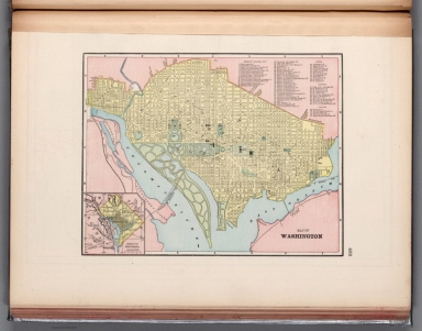
Map of Washington.
List No
14372.272
Note
Map of Washington, D.C. Shows political boundaries, railroads, streets, bridges, parks, bodies of water, drainage, shorelines and islands. Map indexed to indicate place names, with index at upper right. Inset map: District of Columbia. Colored lithograph. Map is 22 x 29 cm, on sheet 33 x 45 cm.
Author
Cram, George Franklin, 1841-1928
Full Title
Greater New York.
List No
14372.278
Note
Map of New York City, New York, with all five boroughs and vicinity. Shows political boundaries, cities, railroads, streets, bridges, parks, bodies of water, drainage, coastlines and islands. Includes a bar scale, given in miles. Colored lithograph. Map is 27 x 34 cm, on sheet 33 x 45 cm.
Author
Cram, George Franklin, 1841-1928
Full Title
Council Bluffs.
List No
14372.287
Note
Map of Council Bluffs, Iowa. Shows political boundaries, railroads, streets, bridges, parks, bodies of water, drainage, shorelines and islands. Colored lithograph. Map is 30 x 26 cm, on sheet 45 x 33 cm.
Author
Cram, George Franklin, 1841-1928
Full Title
Map of the United States of America.
List No
14372.291
Note
Map of the United States. Shows political boundaries, cities, railroads, topography, bodies of water, drainage, shorelines and islands. Relief shown with hachures. Includes latitudinal and longitudinal lines. Inset map: Alaska. Colored lithograph. Map is 32 x 49 cm, on double sheet 45 x 67 cm.
Author
Cram, George Franklin, 1841-1928
Full Title
Denver.
List No
14372.292
Note
Map of Denver, Colorado. Shows political boundaries, railroads, streets, bridges, parks, bodies of water, drainage and shorelines. Colored lithograph. Map is 26 x 33 cm, on sheet 33 x 45 cm.
Author
Cram, George Franklin, 1841-1928
Full Title
New Orleans.
List No
14372.302
Note
Map of New Orleans, Louisiana. Shows political boundaries, railroads, streets, bridges, ferry lines, parks, topography, bodies of water and drainage. Relief shown with hachures. Includes a legend, compass rose with north oriented toward top of sheet, as well as a bar scale given in miles. Map indexed to indicate place names. Colored lithograph. Map is 28 x 24 cm, on sheet 45 x 33 cm.
Author
Cram, George Franklin, 1841-1928
Full Title
Chart of the world on Mercator's Projection.
List No
14372.316
Note
Map of the world on Mercator's Projection. Shows political boundaries, cities, railroads, topography, bodies of water, drainage, coastlines, islands and ocean currents. Relief shown with hachures. Maps include latitudinal and longitudinal lines. Provides figures for square milage and population. Six inset maps: Principal cities of the old world : London -- Paris -- Berlin -- St. Petersburg -- Vienna -- Cairo. With statistical tables on national wealth, debts and militaries in margin. Colored lithograph. Map is 38 x 44 cm, on double sheet 45 x 67 cm.
|


![Composite Map: Ohio : North half. -- Ohio : [South half].](https://www.davidrumsey.com/rumsey/Size2/RUMSEY~8~1/205/14372067.jpg)