Who What Where WhenWHAT
|
Author
[H.S. Crocker Co., Cavagnaro, Milton, Holub, Lee]
Full Title
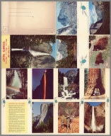
(Covers to) Yosemite Valley. A Mirro-Krome Production by H.S. Corcker Co., Inc. San Francisco, 1. Calif. Copyright 5 Associates 1955. Litho. U.S.A. (cover title) A Pic-tour map: What to do -- Where to go -- What to see : Yosemite Valley.
List No
11523.001
Note
Colored birds-eye-view of Yosemite Valley and vicinity on sheet 55.5x45.5 folded into mailing envelope with pictorial cover 14x23. Produced by 5 Associates, Inc. Shows roads, trails, rivers, place names, camping areas, hotels, and points of interest. Includes list of places to see and stay. On verso: Color photos and text "How Yosemite Valley was formed".
Author
[H.S. Crocker Co., Cavagnaro, Milton, Holub, Lee]
Full Title
(Text Page/View to) Yosemite Valley. A Mirro-Krome Production by H.S. Corcker Co., Inc. San Francisco, 1. Calif. Copyright 5 Associates 1955. Litho. U.S.A. (cover title) A Pic-tour map: What to do -- Where to go -- What to see : Yosemite Valley.
List No
11523.002
Note
Colored birds-eye-view of Yosemite Valley and vicinity on sheet 55.5x45.5 folded into mailing envelope with pictorial cover 14x23. Produced by 5 Associates, Inc. Shows roads, trails, rivers, place names, camping areas, hotels, and points of interest. Includes list of places to see and stay. On verso: Color photos and text "How Yosemite Valley was formed".
Author
[H.S. Crocker Co., Cavagnaro, Milton, Holub, Lee]
Full Title
Yosemite Valley. A Mirro-Krome Production by H.S. Corcker Co., Inc. San Francisco, 1. Calif. Copyright 5 Associates 1955. Litho. U.S.A. (cover title) A Pic-tour map: What to do -- Where to go -- What to see : Yosemite Valley.
List No
11523.003
Note
Colored birds-eye-view of Yosemite Valley and vicinity on sheet 55.5x45.5 folded into mailing envelope with pictorial cover 14x23. Produced by 5 Associates, Inc. Shows roads, trails, rivers, place names, camping areas, hotels, and points of interest. Includes list of places to see and stay. On verso: Color photos and text "How Yosemite Valley was formed".
Author
[Rand McNally and Company, Valley National Bank of Arizona, Avey, George M.]
Full Title
Map of greater Tucson and surrounding area. Published by Valley National Bank ; copyright by Rand McNally & Company. San Francisco. Lithographed in U.S.A. 5076. (insets) University of Arizona campus. (with) Downtown Tucson. (cover title) Street map of Tucson and a pictorial guide of southern Arizona. (on verso) The "Old Pueblo" Tucson: Pictorial guide of Southern Arizona. By George M. Avey. (and map of) State of Arizona.
List No
11525.001
Note
3 Color maps, both sides on sheet 71.5x52, folded to 24 x 11. Shows roads, highways, streets , parks, landmarks, etc. Includes index. On verso: text, map of Arizona and pictorial map of Tucson. with inset of location map. Shows places of interest Native American reservations industry, and recreational activities. Relief shown pictorially. Date estimated.
Author
[Rand McNally and Company, Valley National Bank of Arizona, Avey, George M.]
Full Title
Map of greater Tucson and surrounding area. Published by Valley National Bank ; copyright by Rand McNally & Company. San Francisco. Lithographed in U.S.A. 5076. (insets) University of Arizona campus. (with) Downtown Tucson. (cover title) Street map of Tucson and a pictorial guide of southern Arizona. (on verso) The "Old Pueblo" Tucson: Pictorial guide of Southern Arizona. By George M. Avey. (and map of) State of Arizona.
List No
11525.002
Note
3 Color maps, both sides on sheet 71.5x52, folded to 24 x 11. Shows roads, highways, streets , parks, landmarks, etc. Includes index. On verso: text, map of Arizona and pictorial map of Tucson. with inset of location map. Shows places of interest Native American reservations industry, and recreational activities. Relief shown pictorially. Date estimated.
Author
Miller Printing Company
Full Title
The Great Smoky Mountains National Park. Copyright 1939 by the Miller Printing Company, Ashville, N. C.
List No
11526.000
Note
Color pictorial map of the Great Smoky Mountains National Park, North Carolina and Tennessee. Relief shown pictorially and by spot heights. Shows state lines, park boundaries, roads, highways, trails, places of interest, wildlife, rivers and streams. Includes legend, compass rose oriented with the north to the upper margin, and descriptive text for sites and events.
Author
Smith, Karl
Full Title
Ohio. Karl Smith. Copyrighted 1940 by Karl Smith Cartographer. Louisville, Ky. (inset) Pioneers going down the Ohio River on a flatboat.
List No
11527.000
Note
Pictorial map with title cartouche decorated with the state seal and state flower. Shows cities and towns, forests, agriculture, industry, land marks, rivers, descriptive text for Ohio historical sites and events. Includes decorative compass rose at the top center.
Author
Egypt. Safarah (U.S.)
Full Title
Egypt (MISR). Royal Egyptian Embassy, Washington, D.C. Designed by Picks-S, N. Y. Lithographed in the U.S.A.
List No
11529.000
Note
Color pictorial post WW II propaganda map with Mediterranean Sea and the Royal seal at the top of the map. Shows primary commodities and the country's agricultural, industrial, and educational development, as well as the importance of its location primarily in the Nile River Valley and Gulf of Suez. Includes inset of location map, place names, railroads, rivers, legend and descriptive text.
Author
Riegel, Jacob
Full Title
A pictorial map of Narragansett Bay : including Newport and Jamestown, R.I. Drawn by Jacob Riegel, Jr. Copyright J. Riegel, Jr. 1932.
List No
11530.000
Note
Pictorial map of Narragansett Bay with parts of Jamestown and the Newport shore with decorative title cartouche. The map shows historical and modern day points of interests, including roads, railways, lighthouses, parks, landmarks, forts, forests, ships, sailboats and scenes from various activities. Includes historical notes, the Rhode Island coat of arms and compass rose oriented with the north to the upper right margin.
Author
Illinois State
Full Title
(Covers to) Illinois, its geography, its history. Printed by the authority of the State of Illinois. Copyright 1938 by the State of Illinois. (cover title) Illinois.
List No
11531.001
Note
Pictorial map 52x40 on sheet 55x43 folded to 21.5x9.5. Shows cities, towns, rivers, agriculture and industry. Historical illustrations with text surround the map. Includes compass rose and portraits of Shadrach Bond, first governor of Illinois and Henry Horner present governor of Illinois. On verso includes: drawings, photos or various scenes, text and State's seal, State flag, State's bird and plants.
Author
Illinois State
Full Title
Illinois, its geography, its history. Printed by the authority of the State of Illinois. Copyright 1938 by the State of Illinois. (cover title) Illinois.
List No
11531.002
Note
Pictorial map 52x40 on sheet 55x43 folded to 21.5x9.5. Shows cities, towns, rivers, agriculture and industry. Historical illustrations with text surround the map. Includes compass rose and portraits of Shadrach Bond, first governor of Illinois and Henry Horner present governor of Illinois. On verso includes: drawings, photos or various scenes, text and State's seal, State flag, State's bird and plants.
Author
[United States. Board of Engineers for Rivers and Harbors, United States. Army. Corps of Engineers]
Full Title
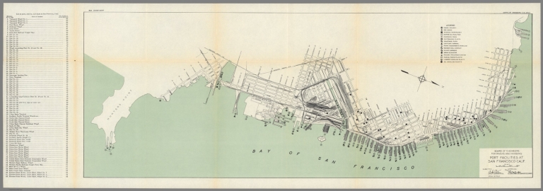
Board of engineers for rivers and harbours : Port facilities at San Francisco, Calif. Drawn by O.LA. (at upper margin) War Department. Corps of Engineers - U.S. Army.
List No
11532.000
Note
Color map on sheet 33x96.5. Shows streets, railroads, and major buildings. Includes legend and list of port facilities with reference to number on the map. Oriented with north toward right margin. Date estimated.
Author
[Maw, Samuel Herbert, Provincial Tourist Bureau, Funk & Wagnalls Company.]
Full Title
(Tourist map of Gaspe Peninsula). S. H. Maw. Provincial Tourist Bureau, Highway Department, Quebec, Canada. May 1929.
List No
11533.001
Note
Color pictorial tourist map of Gaspe Peninsula, Quebec 22.5x45, by Samuel Herbert Maw. Centered on St. Lawrence River. Covers from Quebec City to the Gulf of St. Lawrence. Shown towns, forests, rivers, landmarks, lakes, and wildlife. Includes compass rose oriented with north to top right and Quebec coat of arms. On verso: text and list of roads and highways. Relief shown pictorially. Title supplied by cataloger.
Author
[Maw, Samuel Herbert, Provincial Tourist Bureau, Funk & Wagnalls Company.]
Full Title
(Text Page to) (Tourist map of Gaspe Peninsula). S. H. Maw. Provincial Tourist Bureau, Highway Department, Quebec, Canada. May 1929.
List No
11533.002
Note
Color pictorial tourist map of Gaspe Peninsula, Quebec 22.5x45, by Samuel Herbert Maw. Centered on St. Lawrence River. Covers from Quebec City to the Gulf of St. Lawrence. Shown towns, forests, rivers, landmarks, lakes, and wildlife. Includes compass rose oriented with north to top right and Quebec coat of arms. On verso: text and list of roads and highways. Relief shown pictorially. Title supplied by cataloger.
Author
[Farrow, Charles Vernon (1896-1936), Fuessle & Colman]
Full Title
This is a section of a map of the wondrous isle of manhattan. To be found inside about 40" by 25" and for sale everywhere 50 Cents. Published by Fuessle & Colman, 6E. 8th. St. New York.
List No
11534.000
Note
A cover envelope for Farrow's pictorial map of Manhattan. See our full size versions This appears to be the only major city map that Farrow designed. Published by Fuessle and Colman. The map highlights scores of actual attractions like landmarks and parks. Familiar buildings and streets are labeled, as is the city’s transit system at the time, with elevated tracks running along the avenues. Date estimated.
Author
Rand McNally and Company
Full Title
(Covers to) This is New York's famous Empire State Buildings. Copyright by Rand McNally and Company. Lithographed in U.S.A. (Cover title) Atop the Empire State building : Night and day, the view that takes your breath away.
List No
11535.001
Note
Color circular fold-out brochure, based on the panoramic views from the Observatory of the Empire State Building,24x30 on sheet 40x30, with descriptive text at the top and numeric key to the buildings and landmarks around the Empire State Building. Includes note: "The 3-dimensional panoramic map (below) was designed by Rand McNally & Company ... for the "Empire State." Each quadrant conforms to the view registered by the eye from the 86th floor observatory." On verso: color photographs and detail illustration of the Building "What everybody wants to know about the Empire State Building". Date estimated.
Author
Rand McNally and Company
Full Title
This is New York's famous Empire State Buildings. Copyright by Rand McNally and Company. Lithographed in U.S.A. (Cover title) Atop the Empire State building : Night and day, the view that takes your breath away.
List No
11535.002
Note
Color circular fold-out brochure, based on the panoramic views from the Observatory of the Empire State Building,24x30 on sheet 40x30, with descriptive text at the top and numeric key to the buildings and landmarks around the Empire State Building. Includes note: "The 3-dimensional panoramic map (below) was designed by Rand McNally & Company ... for the "Empire State." Each quadrant conforms to the view registered by the eye from the 86th floor observatory." On verso: color photographs and detail illustration of the Building "What everybody wants to know about the Empire State Building". Date estimated.
Author
[Zucoli, Leone, Pirola, Gaetano]
Full Title
Panorama orografico e pittoresco della citta e contorni di Milano preso dalla somita della cattedrale. Dedicato al Sig.r Conte Ambrogio Nava Amministratore della Ven.da Fabb.ca del duomo dall'editore Gaetano Pirola. Leone Zucoli inc. (inset view) Duomo di Milano stato Fondato nel 1386.
List No
11536.000
Note
Circular copper engraving map of the city, which is split up to three hundred and sixty degrees, with vignette of the main monuments, designed and specified at the center. Includes place names and pictorial views of buildings, landmarks, within city walls, and mountain names on the edge. Drawn and engraved by Leone Zucoli. Includes legend refers to various parts of the cathedral and two crossed swords tell us the places of battles of 1859. Date estimated.
Author
Kearfott, Clarence Baker
Full Title
A map of the Appalachian Region : showing localities of historic interest, places of natural beauty & wonder and public highroads thereto. Copyright, Clarence Baker Kearfott.
List No
11537.000
Note
Pictorial map depicting the history and landmarks of the Appalachian region. Covers parts of Kentucky, West Virginia, Virginia, Tennessee and North Carolina. Detailed border depicting historical scenes and events from the early settlements of the region during the 18th and 19th centuries. Map shows landmarks, roads, the Appalachian trail, mountains, rivers, lakes, state boundaries, cities, towns, portraits and scenes representing Recreation, Agriculture, Transportation, industry and and the camel from the Camel cigarettes package at Winston Salem, North Carolina, with the city's nickname "Camel City. Include a cartouche in an oval frame, a compass rose and a color vignette of horses on a racetrack.
Author
Falk-Verlag
Full Title
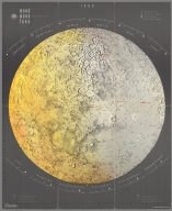
(Covers to) Mond. Moon. Lune. 1969. Copyright 1968 by Falk-verlag. Germany. Die Grosse Karte vom Mond.
List No
11538.001
Note
Color map on sheet 53 x 43 folded to 26 x 15 cm. "Relief as seen through astronomic telescope." On verso: text: Mondnamen-Verzeichnis. Daten der Monderforschung. Wissenswertes uber den Mond. Map: Mondruckseite, 1:16,000,000. Includes notes.
Author
Falk-Verlag
Full Title
(Text Page to) Mond. Moon. Lune. 1969. Copyright 1968 by Falk-verlag. Germany. Die Grosse Karte vom Mond.
List No
11538.002
Note
Color map on sheet 53 x 43 folded to 26 x 15 cm. "Relief as seen through astronomic telescope." On verso: text: Mondnamen-Verzeichnis. Daten der Monderforschung. Wissenswertes uber den Mond. Map: Mondruckseite, 1:16,000,000. Includes notes.
Author
Falk-Verlag
Full Title
Mond. Moon. Lune. 1969. Copyright 1968 by Falk-verlag. Germany. Die Grosse Karte vom Mond.
List No
11538.003
Note
Color map on sheet 53 x 43 folded to 26 x 15 cm. "Relief as seen through astronomic telescope." On verso: text: Mondnamen-Verzeichnis. Daten der Monderforschung. Wissenswertes uber den Mond. Map: Mondruckseite, 1:16,000,000. Includes notes.
Author
[Rand McNally and Company, Sun Oil Company]
Full Title
(Covers to) Historical, pictorial points of interest map of New York. Prepared exclusively for Sun Oil Company 1608 Walnut St. Philadelphia, PA. Copyright by Rand McNally, Chicago. L4-. P-3. Sunoco Auto road map New York. (insets) Metropolitan district: New York City. (with) Albany, N.Y. (with) Lower New York and Long Island. (cover title) Road map and historical guide New York. Gas Sunoco Oils.
List No
11539.001
Note
2 color maps on 1 sheet : both sides, 51 x 54 and 45 x 68 on sheet 56 x 71 folded into 17.5x9. Pictorial map and road map of New York. Pictorial map divided into two segments, shows state boundaries, roads, cities, landmarks, bridges, historical places and events, rivers, mountains, parks, Indian reservations, and places of interest. Includes compass rose and index to places of interest. On verso: Includes text, mileage chart, and advertisement. Relief shown pictorially. Date estimated.
Author
[Rand McNally and Company, Sun Oil Company]
Full Title
Historical, pictorial points of interest map of New York. Prepared exclusively for Sun Oil Company 1608 Walnut St. Philadelphia, PA. Copyright by Rand McNally, Chicago. L4-. P-3. Sunoco Auto road map New York. (insets) Metropolitan district: New York City. (with) Albany, N.Y. (with) Lower New York and Long Island. (cover title) Road map and historical guide New York. Gas Sunoco Oils.
List No
11539.002
Note
2 color maps on 1 sheet : both sides, 51 x 54 and 45 x 68 on sheet 56 x 71 folded into 17.5x9. Pictorial map and road map of New York. Pictorial map divided into two segments, shows state boundaries, roads, cities, landmarks, bridges, historical places and events, rivers, mountains, parks, Indian reservations, and places of interest. Includes compass rose and index to places of interest. On verso: Includes text, mileage chart, and advertisement. Relief shown pictorially. Date estimated.
Author
[Rand McNally and Company, Sun Oil Company]
Full Title
Historical, pictorial points of interest map of New York. Prepared exclusively for Sun Oil Company 1608 Walnut St. Philadelphia, PA. Copyright by Rand McNally, Chicago. L4-. P-3. Sunoco Auto road map New York. (insets) Metropolitan district: New York City. (with) Albany, N.Y. (with) Lower New York and Long Island. (cover title) Road map and historical guide New York. Gas Sunoco Oils.
List No
11539.003
Note
2 color maps on 1 sheet : both sides, 51 x 54 and 45 x 68 on sheet 56 x 71 folded into 17.5x9. Pictorial map and road map of New York. Pictorial map divided into two segments, shows state boundaries, roads, cities, landmarks, bridges, historical places and events, rivers, mountains, parks, Indian reservations, and places of interest. Includes compass rose and index to places of interest. On verso: Includes text, mileage chart, and advertisement. Relief shown pictorially. Date estimated.
Author
[Gray, Ormando Willis, Walling, H. F.]
Full Title
(Covers to) Official topographical atlas of Massachusetts, from astronomical, trigonometrical and various local surveys; compiled and corrected by H.F. Walling & O.W. Gray, 102 Chauncy St., Boston. Published by Stedman, Brown & Lyon, 1871.
List No
1154A
Note
Bound in half leather dark brown cloth covered boards with "Atlas of the State of Massachusetts" stamped in gilt on the front cover and blind stamped on the back.
Author
[Gray, Ormando Willis, Walling, H. F.]
Full Title
(Title Page to) Official topographical atlas of Massachusetts, from astronomical, trigonometrical and various local surveys; compiled and corrected by H.F. Walling & O.W. Gray, 102 Chauncy St., Boston. Published by Stedman, Brown & Lyon, 1871.
List No
1154B
Note
Includes illustration.
Author
[Gray, Ormando Willis, Walling, H. F.]
Full Title
(Contents to) Official topographical atlas of Massachusetts, from astronomical, trigonometrical and various local surveys; compiled and corrected by H.F. Walling & O.W. Gray, 102 Chauncy St., Boston. Published by Stedman, Brown & Lyon, 1871.
List No
1154C
Note
Table of contents.
Author
[Gray, Ormando Willis, Hitchcock, Charles H. (Charles Henry), 1836-1919, Walling, H. F.]
Full Title
Geological map of Massachusetts, compiled by C.H. Hitchcock, Ph.D., professor of geology in Dartmouth College. H.F. Walling & O.W. Gray, Boston, 1871.
List No
1154.001
Note
Hand col. lithographed map. Shows 24 geologic units plus deposits or beds of marl, iron, lead, copper, manganese and zinc. Includes text and drawing of Paradoxides harlani (fig. 1.).
Author
[Blodget, Lorin, Gray, Ormando Willis, Walling, H. F.]
Full Title
Climatological map of Massachusetts showing the average temperature, amount of rain fall &c. by Lorin Blodgett (i.e. Blodget. H.F. Walling & O.W. Gray, Boston, 1871)
List No
1154.002
Note
Lithographed map. Includes text: The climate of Massachusetts by Lorin Blodget ...
Author
[Gray, Ormando Willis, Walling, H. F.]
Full Title
Map of the United States and territories. H.F. Walling & O.W. Gray, Boston, 1871.
List No
1154.003
Note
Hand col. lithographed map. Shows railroads and proposed routes, emigrant roads, etc. States and territories in full color. Relief shown by hachures and spot heights. Prime meridians: Washington and Greenwich.
Author
[Gray, Ormando Willis, Walling, H. F.]
Full Title
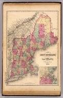
Map of New England with adjacent portions of New York & Canada. (with) 15 miles around Boston. H.F. Walling & O.W. Gray, Boston, 1871.
List No
1154.004
Note
Hand col. lithographed map. Relief shown by hachures. Shows railroads, counties, towns, settlements, etc.
Author
[Gray, Ormando Willis, Walling, H. F.]
Full Title
Map of Massachusetts comprising counties, towns, villages, railroads, stations, etc. H.F. Walling & O.W. Gray, Boston, 1871.
List No
1154.005
Note
Hand col. lithographed map. Includes table of "Railways of Massachusetts" and "Boston & vic. railway stations." "Entered according to Act of Congress in the year 1870 by Walling & Gray in the Office of the Librarian of Congress."
Full Title
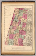
Berkshire County. (H.F. Walling & O.W. Gray, Boston, 1871)
List No
1154.006
Note
Hand col. lithographed map. Relief shown by hachures and spot heights. Shows towns, settlements, school houses, churches, roads, railroads, canals, marshes, etc.
Full Title
Franklin County. (H.F. Walling & O.W. Gray, Boston, 1871)
List No
1154.007
Note
Hand col. lithographed map. Relief shown by hachures. Shows towns, settlements, school houses, churches, roads, railroads, canals, marshes, etc.
Full Title
Hampshire County, Hampden County. (H.F. Walling & O.W. Gray, Boston, 1871)
List No
1154.008
Note
Hand col. lithographed map. Relief shown by hachures and spot heights. Shows towns, settlements, school houses, churches, roads, railroads, canals, marshes, etc.
Full Title
Worcester County. (H.F. Walling & O.W. Gray, Boston, 1871)
List No
1154.009
Note
Hand col. lithographed map. Relief shown by hachures and spot heights. Shows towns, settlements, school houses, churches, roads, railroads, etc.
Full Title
Middlesex County. (H.F. Walling & O.W. Gray, Boston, 1871)
List No
1154.010
Note
Hand col. lithographed map. Relief shown by hachures and spot heights. Shows towns, settlements, school houses, churches, roads, railroads, marshes, etc.
Full Title
Essex County. Norfolk County. (H.F. Walling & O.W. Gray, Boston, 1871)
List No
1154.011
Note
Two hand col. lithographed maps on 1 sheet. Relief shown by hachures. Shows towns, settlements, school houses, churches, roads, railroads, marshes, etc.
Full Title
Bristol County. (H.F. Walling & O.W. Gray, Boston, 1871)
List No
1154.012
Note
Hand col. lithographed map. Relief shown by hachures and spot heights. Shows towns, settlements, school houses, churches, roads, railroads, marshes, etc.
Full Title
Plymouth County. (H.F. Walling & O.W. Gray, Boston, 1871)
List No
1154.013
Note
Hand col. lithographed map. Relief shown by hachures and spot heights. Shows towns, settlements, school houses, churches, roads, railroads, marshes, etc.
Full Title
Barnstable County. (with) Dukes (County). (with) Nantucket. (H.F. Walling & O.W. Gray, Boston, 1871)
List No
1154.014
Note
Hand col. lithographed map. Relief shown by hachures. Shows towns, settlements, school houses, churches, roads, railroads, marshes, etc.
Author
[Gray, Ormando Willis, Walling, H. F.]
Full Title
Map of the compact portions of Boston and the adjacent cities and towns. H.F. Walling & O.W. Gray, Boston, 1871.
List No
1154.015
Note
Hand col. lithographed map. Shows wards, streets, railroads, major buildings, bridges, ferries, etc. Inset: Map showing the present limits of the city of Boston, 1871.
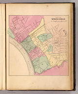
Full Title
City of Springfield. (H.F. Walling & O.W. Gray, Boston, 1871)
List No
1154.016
Note
Hand col. lithographed map. Shows wards, streets, railroads, major buildings, bridges, etc.
Full Title
City of Worcester. (H.F. Walling & O.W. Gray, Boston, 1871)
List No
1154.017
Note
Hand col. lithographed map. Shows wards, streets, railroads, major buildings, etc.
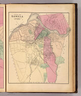
Author
Baker, R. W.
Full Title
City of Lowell. Reduced by permission from the large map by R.W. Baker. (H.F. Walling & O.W. Gray, Boston, 1871)
List No
1154.018
Note
Hand col. lithographed map. Shows wards, streets, railroads, major buildings, commons, cemeteries, bridges, etc.
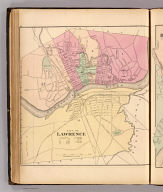
Full Title
City of Lawrence. (H.F. Walling & O.W. Gray, Boston, 1871)
List No
1154.019
Note
Hand col. lithographed map. Shows wards, streets, railroads, major buildings, bridges, dam, commons, cemetery, etc.
Full Title
City of Haverhill. (H.F. Walling & O.W. Gray, Boston, 1871)
List No
1154.020
Note
Hand col. lithographed map. Shows wards, streets, railroads, major buildings, bridges, commons, cemeteries, etc.
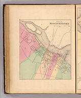
Full Title
City of Newburyport. (H.F. Walling & O.W. Gray, Boston, 1871)
List No
1154.021
Note
Hand col. lithographed map. Shows wards, streets, railroads, major buildings, bridges, etc.
Full Title
City of Salem. (H.F. Walling & O.W. Gray, Boston, 1871)
List No
1154.022
Note
Hand col. lithographed map. Shows wards, streets, railroads, major buildings, bridges, cemeteries, etc.
|