Who What Where WhenWHAT
|
Author
Lopez de Vargas Machuca, Tomas (1730-1802)
Full Title
Mapa del Reyno de Sevilla, dibidido en su Arzobispado, Obispado, y Tesorerías ... Por D. Thomas Lopez pensionista de S.M. ano de 1767. (to accompany) Atlas geografico de Espana ... por Don Tomas Lopez ... Tomo Primero. Ano 1810.
List No
11510.084
Note
1 map on 4 sheets. Engraved outline hand colored map with title carthouche. Shows administrative divisions, major cities, towns, villages, landmarks, public buildings, roads, rivers, canals, forests and mountains. Relief shown pictorially. Prime meridian is Tenerife. Includes explanation to symbols, descriptive text, and alphanumeric key to convents and monasteries.
Author
Lopez de Vargas Machuca, Tomas (1730-1802)
Full Title
(Composite map) Mapa del Reyno de Sevilla, dibidido en su Arzobispado, Obispado, y Tesorerías ... Por D. Thomas Lopez pensionista de S.M. ano de 1767. (to accompany) Atlas geografico de Espana ... por Don Tomas Lopez ... Tomo Primero. Ano 1810.
List No
11510.085
Note
Composite map of Reyno de Sevilla, sheets 58-61. 1 map on 4 sheets. Engraved outline hand colored map with title carthouche. Shows administrative divisions, major cities, towns, villages, landmarks, public buildings, roads, rivers, canals, forests and mountains. Relief shown pictorially and by hachures. Prime meridian is Tenerife. Includes explanation to symbols, descriptive text, and alphanumeric key to convents and monasteries.
Author
Lopez de Vargas Machuca, Tomas (1730-1802)
Full Title
Mapa geografico del Reyno de Cordoba : Comprehende los Partidos Jurisdicionales de Cordoba, el Carpio, los Pedroches y Santa Eufemia ... Por Don Tomas Lopez, Geografo de los dominios de S.M. Madrid ano de 1797. (to accompany) Atlas geografico de Espana ... por Don Tomas Lopez ... Tomo Primero. Ano 1810.
List No
11510.086
Note
1 map on 2 sheets. Engraved outline hand colored map with title carthouche. Shows administrative divisions, major cities, towns, villages, landmarks, public buildings, roads, rivers, canals, forests and mountains. Relief shown pictorially and by hachures. Prime meridian is Tenerife. Includes explanation to symbols, descriptive text, and alphanumeric key to convents and monasteries.
Author
Lopez de Vargas Machuca, Tomas (1730-1802)
Full Title
Mapa geografico del Reyno de Cordoba : Comprehende los Partidos Jurisdicionales de Cordoba, el Carpio, los Pedroches y Santa Eufemia ... Por Don Tomas Lopez, Geografo de los dominios de S.M. Madrid ano de 1797. (to accompany) Atlas geografico de Espana ... por Don Tomas Lopez ... Tomo Primero. Ano 1810.
List No
11510.087
Note
1 map on 2 sheets. Engraved outline hand colored map with title carthouche. Shows administrative divisions, major cities, towns, villages, landmarks, public buildings, roads, rivers, canals, forests and mountains. Relief shown pictorially and by hachures. Prime meridian is Tenerife. Includes explanation to symbols, descriptive text, and alphanumeric key to convents and monasteries.
Author
Lopez de Vargas Machuca, Tomas (1730-1802)
Full Title
(Composite map) Mapa geografico del Reyno de Cordoba : Comprehende los Partidos Jurisdicionales de Cordoba, el Carpio, los Pedroches y Santa Eufemia ... Por Don Tomas Lopez, Geografo de los dominios de S.M. Madrid ano de 1797. (to accompany) Atlas geografico de Espana ... por Don Tomas Lopez ... Tomo Primero. Ano 1810.
List No
11510.088
Note
Composite map of Cordoba Provincia, sheets 62-63. 1 map on 2 sheets. Engraved outline hand colored map with title carthouche. Shows administrative divisions, major cities, towns, villages, landmarks, public buildings, roads, rivers, canals, forests and mountains. Relief shown pictorially and by hachures. Prime meridian is Tenerife. Includes explanation to symbols, descriptive text, and alphanumeric key to convents and monasteries.
Author
Lopez de Vargas Machuca, Tomas (1730-1802)
Full Title
Mapa geografico del Reyno de Jaen, dividido en los Partidos de Jaen, Baeza, Ubeda, Andujar, Martos y las poblaciones de Sierra Morena ... Por Don Tomas Lopez, Geografo de los dominios de S.M. ... Madrid ano de 1787. (to accompany) Atlas geografico de Espana ... por Don Tomas Lopez ... Tomo Primero. Ano 1810.
List No
11510.089
Note
Engraved outline hand colored map with title carthouche. Shows administrative divisions, major cities, towns, villages, landmarks, public buildings, roads, rivers, canals, forests and mountains. Relief shown pictorially and by hachures. Prime meridian is Tenerife. Includes explanation to symbols, descriptive text, and numeric key to convents and monasteries.
Author
Lopez de Vargas Machuca, Tomas (1730-1802)
Full Title
Mapa geografico del Reyno de Granada : contiene los partidos de la Ciudad de Granada ... Por Don Tomas Lopez, Geografo de los dominios de S.M. ... Madrid ano de 1795. (to accompany) Atlas geografico de Espana ... por Don Tomas Lopez ... Tomo Primero. Ano 1810. (inset) Costas de Espana y de África.
List No
11510.090
Note
1 map on 4 sheets. Engraved outline hand colored map with title carthouche. Shows administrative divisions, major cities, towns, villages, landmarks, public buildings, roads, rivers, canals, forests and mountains. Relief shown pictorially and by hachures. Prime meridian is Tenerife. Includes explanation to symbols, descriptive text, and key to convents and monasteries.
Author
Lopez de Vargas Machuca, Tomas (1730-1802)
Full Title
Mapa geografico del Reyno de Granada : contiene los partidos de la Ciudad de Granada ... Por Don Tomas Lopez, Geografo de los dominios de S.M. ... Madrid ano de 1795. (to accompany) Atlas geografico de Espana ... por Don Tomas Lopez ... Tomo Primero. Ano 1810. (inset) Costas de Espana y de África.
List No
11510.091
Note
1 map on 4 sheets. Engraved outline hand colored map with title carthouche. Shows administrative divisions, major cities, towns, villages, landmarks, public buildings, roads, rivers, canals, forests and mountains. Relief shown pictorially and by hachures. Prime meridian is Tenerife. Includes explanation to symbols, descriptive text, and key to convents and monasteries.
Author
Lopez de Vargas Machuca, Tomas (1730-1802)
Full Title
Mapa geografico del Reyno de Granada : contiene los partidos de la Ciudad de Granada ... Por Don Tomas Lopez, Geografo de los dominios de S.M. ... Madrid ano de 1795. (to accompany) Atlas geografico de Espana ... por Don Tomas Lopez ... Tomo Primero. Ano 1810. (inset) Costas de Espana y de África.
List No
11510.092
Note
1 map on 4 sheets. Engraved outline hand colored map with title carthouche. Shows administrative divisions, major cities, towns, villages, landmarks, public buildings, roads, rivers, canals, forests and mountains. Relief shown pictorially and by hachures. Prime meridian is Tenerife. Includes explanation to symbols, descriptive text, and key to convents and monasteries.
Author
Lopez de Vargas Machuca, Tomas (1730-1802)
Full Title
Mapa geografico del Reyno de Granada : contiene los partidos de la Ciudad de Granada ... Por Don Tomas Lopez, Geografo de los dominios de S.M. ... Madrid ano de 1795. (to accompany) Atlas geografico de Espana ... por Don Tomas Lopez ... Tomo Primero. Ano 1810. (inset) Costas de Espana y de África.
List No
11510.093
Note
1 map on 4 sheets. Engraved outline hand colored map with title carthouche. Shows administrative divisions, major cities, towns, villages, landmarks, public buildings, roads, rivers, canals, forests and mountains. Relief shown pictorially and by hachures. Prime meridian is Tenerife. Includes explanation to symbols, descriptive text, and key to convents and monasteries.
Author
Lopez de Vargas Machuca, Tomas (1730-1802)
Full Title
(Composite map) Mapa geografico del Reyno de Granada : contiene los partidos de la Ciudad de Granada ... Por Don Tomas Lopez, Geografo de los dominios de S.M. ... Madrid ano de 1795. (to accompany) Atlas geografico de Espana ... por Don Tomas Lopez ... Tomo Primero. Ano 1810. (inset) Costas de Espana y de África.
List No
11510.094
Note
Composite map of Reyno de Granada, sheets 65-68. 1 map on 4 sheets. Engraved outline hand colored map with title carthouche. Shows administrative divisions, major cities, towns, villages, landmarks, public buildings, roads, rivers, canals, forests and mountains. Relief shown pictorially and by hachures. Prime meridian is Tenerife. Includes explanation to symbols, descriptive text, and key to convents and monasteries.
Author
Lopez de Vargas Machuca, Tomas (1730-1802)
Full Title
Mapa del obispado y Reyno de Murcia ... Por el Geografo D. Thomas Lopez ...1768. (to accompany) Atlas geografico de Espana ... por Don Tomas Lopez ... Tomo Primero. Ano 1810.
List No
11510.095
Note
Engraved outline hand colored map with title carthouche. Shows administrative divisions, major cities, towns, villages, landmarks, public buildings, roads, rivers, canals, forests and mountains. Relief shown pictorially and by hachures. Prime meridian is Tenerife. Includes explanation to symbols, descriptive text, and key to convents and monasteries. Note: Se hallara este con todas las obras del Autor en Madrid, Calle de las Carretas, frente de la Imprenta de la Gaceta.
Author
Lopez de Vargas Machuca, Tomas (1730-1802)
Full Title
Mapa del Reyno de Aragon ... Por D. Thomas Lopez, pensionista de S. M. 1765. (to accompany) Atlas geografico de Espana ... por Don Tomas Lopez ... Tomo Primero. Ano 1810.
List No
11510.096
Note
1 map on 4 sheets. Engraved outline hand colored map with title carthouche. Shows administrative divisions, major cities, towns, villages, landmarks, public buildings, roads, rivers, canals, forests and mountains. Relief shown pictorially and by hachures. Prime meridian is Tenerife. Includes explanation to symbols, descriptive text, and key to convents and monasteries.
Author
Lopez de Vargas Machuca, Tomas (1730-1802)
Full Title
Mapa del Reyno de Aragon ... Por D. Thomas Lopez, pensionista de S. M. 1765. (to accompany) Atlas geografico de Espana ... por Don Tomas Lopez ... Tomo Primero. Ano 1810.
List No
11510.097
Note
1 map on 4 sheets. Engraved outline hand colored map with title carthouche. Shows administrative divisions, major cities, towns, villages, landmarks, public buildings, roads, rivers, canals, forests and mountains. Relief shown pictorially and by hachures. Prime meridian is Tenerife. Includes explanation to symbols, descriptive text, and key to convents and monasteries.
Author
Lopez de Vargas Machuca, Tomas (1730-1802)
Full Title
Mapa del Reyno de Aragon ... Por D. Thomas Lopez, pensionista de S. M. 1765. (to accompany) Atlas geografico de Espana ... por Don Tomas Lopez ... Tomo Primero. Ano 1810.
List No
11510.098
Note
1 map on 4 sheets. Engraved outline hand colored map with title carthouche. Shows administrative divisions, major cities, towns, villages, landmarks, public buildings, roads, rivers, canals, forests and mountains. Relief shown pictorially and by hachures. Prime meridian is Tenerife. Includes explanation to symbols, descriptive text, and key to convents and monasteries.
Author
Lopez de Vargas Machuca, Tomas (1730-1802)
Full Title
Mapa del Reyno de Aragon ... Por D. Thomas Lopez, pensionista de S. M. 1765. (to accompany) Atlas geografico de Espana ... por Don Tomas Lopez ... Tomo Primero. Ano 1810.
List No
11510.099
Note
1 map on 4 sheets. Engraved outline hand colored map with title carthouche. Shows administrative divisions, major cities, towns, villages, landmarks, public buildings, roads, rivers, canals, forests and mountains. Relief shown pictorially and by hachures. Prime meridian is Tenerife. Includes explanation to symbols, descriptive text, and key to convents and monasteries.
Author
Lopez de Vargas Machuca, Tomas (1730-1802)
Full Title
(Composite map) Mapa del Reyno de Aragon ... Por D. Thomas Lopez, pensionista de S. M. 1765. (to accompany) Atlas geografico de Espana ... por Don Tomas Lopez ... Tomo Primero. Ano 1810.
List No
11510.100
Note
Composite map of Reyno de Aragon, sheets 70-73. 1 map on 4 sheets. Engraved outline hand colored map with title carthouche. Shows administrative divisions, major cities, towns, villages, landmarks, public buildings, roads, rivers, canals, forests and mountains. Relief shown pictorially and by hachures. Prime meridian is Tenerife. Includes explanation to symbols, descriptive text, and key to convents and monasteries.
Author
Lopez de Vargas Machuca, Tomas (1730-1802)
Full Title
Mapa del principado de Cataluna ... Por D. Thomas Lopez y Vargas ... 1776. (to accompany) Atlas geografico de Espana ... por Don Tomas Lopez ... Tomo Primero. Ano 1810.
List No
11510.101
Note
1 map on 4 sheets. Engraved outline hand colored map with title carthouche. Shows administrative divisions, major cities, towns, villages, landmarks, public buildings, roads, rivers, canals, forests and mountains. Relief shown pictorially and by hachures. Prime meridian is Tenerife. Includes explanation to symbols, descriptive text, and key to convents and monasteries.
Author
Lopez de Vargas Machuca, Tomas (1730-1802)
Full Title
Mapa del principado de Cataluna ... Por D. Thomas Lopez y Vargas ... 1776. (to accompany) Atlas geografico de Espana ... por Don Tomas Lopez ... Tomo Primero. Ano 1810.
List No
11510.102
Note
1 map on 4 sheets. Engraved outline hand colored map with title carthouche. Shows administrative divisions, major cities, towns, villages, landmarks, public buildings, roads, rivers, canals, forests and mountains. Relief shown pictorially and by hachures. Prime meridian is Tenerife. Includes explanation to symbols, descriptive text, and key to convents and monasteries.
Author
Lopez de Vargas Machuca, Tomas (1730-1802)
Full Title
Mapa del principado de Cataluna ... Por D. Thomas Lopez y Vargas ... 1776. (to accompany) Atlas geografico de Espana ... por Don Tomas Lopez ... Tomo Primero. Ano 1810.
List No
11510.103
Note
1 map on 4 sheets. Engraved outline hand colored map with title carthouche. Shows administrative divisions, major cities, towns, villages, landmarks, public buildings, roads, rivers, canals, forests and mountains. Relief shown pictorially and by hachures. Prime meridian is Tenerife. Includes explanation to symbols, descriptive text, and key to convents and monasteries.
Author
Lopez de Vargas Machuca, Tomas (1730-1802)
Full Title
Mapa del principado de Cataluna ... Por D. Thomas Lopez y Vargas ... 1776. (to accompany) Atlas geografico de Espana ... por Don Tomas Lopez ... Tomo Primero. Ano 1810.
List No
11510.104
Note
1 map on 4 sheets. Engraved outline hand colored map with title carthouche. Shows administrative divisions, major cities, towns, villages, landmarks, public buildings, roads, rivers, canals, forests and mountains. Relief shown pictorially and by hachures. Prime meridian is Tenerife. Includes explanation to symbols, descriptive text, and key to convents and monasteries.
Author
Lopez de Vargas Machuca, Tomas (1730-1802)
Full Title
(Composite map) Mapa del principado de Cataluna ... Por D. Thomas Lopez y Vargas ... 1776. (to accompany) Atlas geografico de Espana ... por Don Tomas Lopez ... Tomo Primero. Ano 1810.
List No
11510.105
Note
Composite map of Cataluna, sheets 74-77. 1 map on 4 sheets. Engraved outline hand colored map with title carthouche. Shows administrative divisions, major cities, towns, villages, landmarks, public buildings, roads, rivers, canals, forests and mountains. Relief shown pictorially and by hachures. Prime meridian is Tenerife. Includes explanation to symbols, descriptive text, and key to convents and monasteries.
Author
Lopez de Vargas Machuca, Tomas (1730-1802)
Full Title
Mapa geografico del reyno de Valencia : dividido en sus trece Gobernaciones o Partidos ... Por Don Thomas Lopez ... 1788. (to accompany) Atlas geografico de Espana ... por Don Tomas Lopez ... Tomo Primero. Ano 1810. (inset) Mapa de la particular contribucion y huerta de Valencia.
List No
11510.106
Note
1 map on 4 sheets. Engraved outline hand colored map with title carthouche. Shows administrative divisions, major cities, towns, villages, landmarks, public buildings, roads, rivers, canals, forests and mountains. Relief shown pictorially and by hachures. Prime meridian is Tenerife. Includes explanation to symbols, descriptive text, and key to convents and monasteries.
Author
Lopez de Vargas Machuca, Tomas (1730-1802)
Full Title
Mapa geografico del reyno de Valencia : dividido en sus trece Gobernaciones o Partidos ... Por Don Thomas Lopez ... 1788. (to accompany) Atlas geografico de Espana ... por Don Tomas Lopez ... Tomo Primero. Ano 1810. (inset) Mapa de la particular contribucion y huerta de Valencia.
List No
11510.107
Note
1 map on 4 sheets. Engraved outline hand colored map with title carthouche. Shows administrative divisions, major cities, towns, villages, landmarks, public buildings, roads, rivers, canals, forests and mountains. Relief shown pictorially and by hachures. Prime meridian is Tenerife. Includes explanation to symbols, descriptive text, and key to convents and monasteries.
Author
Lopez de Vargas Machuca, Tomas (1730-1802)
Full Title
Mapa geografico del reyno de Valencia : dividido en sus trece Gobernaciones o Partidos ... Por Don Thomas Lopez ... 1788. (to accompany) Atlas geografico de Espana ... por Don Tomas Lopez ... Tomo Primero. Ano 1810. (inset) Mapa de la particular contribucion y huerta de Valencia.
List No
11510.108
Note
1 map on 4 sheets. Engraved outline hand colored map with title carthouche. Shows administrative divisions, major cities, towns, villages, landmarks, public buildings, roads, rivers, canals, forests and mountains. Relief shown pictorially and by hachures. Prime meridian is Tenerife. Includes explanation to symbols, descriptive text, and key to convents and monasteries.
Author
Lopez de Vargas Machuca, Tomas (1730-1802)
Full Title
Mapa geografico del reyno de Valencia : dividido en sus trece Gobernaciones o Partidos ... Por Don Thomas Lopez ... 1788. (to accompany) Atlas geografico de Espana ... por Don Tomas Lopez ... Tomo Primero. Ano 1810. (inset) Mapa de la particular contribucion y huerta de Valencia.
List No
11510.109
Note
1 map on 4 sheets. Engraved outline hand colored map with title carthouche. Shows administrative divisions, major cities, towns, villages, landmarks, public buildings, roads, rivers, canals, forests and mountains. Relief shown pictorially and by hachures. Prime meridian is Tenerife. Includes explanation to symbols, descriptive text, and key to convents and monasteries.
Author
Lopez de Vargas Machuca, Tomas (1730-1802)
Full Title
(Composite map) Mapa geografico del reyno de Valencia : dividido en sus trece Gobernaciones o Partidos ... Por Don Thomas Lopez ... 1788. (to accompany) Atlas geografico de Espana ... por Don Tomas Lopez ... Tomo Primero. Ano 1810. (inset) Mapa de la particular contribucion y huerta de Valencia.
List No
11510.110
Note
Composite map of Reyno de Valencia, sheets 78-81. 1 map on 4 sheets. Engraved outline hand colored map with title carthouche. Shows administrative divisions, major cities, towns, villages, landmarks, public buildings, roads, rivers, canals, forests and mountains. Relief shown pictorially and by hachures. Prime meridian is Tenerife. Includes explanation to symbols, descriptive text, and key to convents and monasteries.
Author
Lopez de Vargas Machuca, Tomas (1730-1802)
Full Title
Mapa geografico y general de las Islas Baleares y Pithyusas. Por Don Tomas Lopez, Geografo de los Dominios de S.M. ... Madrid, ano de 1793. (to accompany) Atlas geografico de Espana ... por Don Tomas Lopez ... Tomo Primero. Ano 1810.
List No
11510.111
Note
1 map on 2 sheets, folded. Engraved outline hand colored map with title carthouche. Shows administrative divisions, major cities, towns, villages, landmarks, public buildings, roads, rivers, canals, forests and mountains. Relief shown pictorially. Depths shown by soundings. Includes explanation to symbols and descriptive text.
Author
Lopez de Vargas Machuca, Tomas (1730-1802)
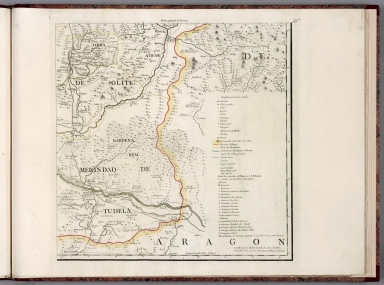
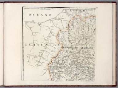
Full Title
Mapa del Reyno de Navarra. Por Don Tomas Lopez, Geografo de los Dominios de S.M. ... Madrid, ano de 1772. (to accompany) Atlas geografico de Espana ... por Don Tomas Lopez ... Tomo Primero. Ano 1810.
List No
11510.112
Note
1 map on 4 sheets. Engraved outline hand colored map with title carthouche. Shows administrative divisions, major cities, towns, villages, landmarks, public buildings, roads, rivers, canals, forests and mountains. Relief shown pictorially. Prime meridian is Tenerife. Includes explanation to symbols and descriptive text.
Author
Lopez de Vargas Machuca, Tomas (1730-1802)
Full Title
Mapa del Reyno de Navarra. Por Don Tomas Lopez, Geografo de los Dominios de S.M. ... Madrid, ano de 1772. (to accompany) Atlas geografico de Espana ... por Don Tomas Lopez ... Tomo Primero. Ano 1810.
List No
11510.113
Note
1 map on 4 sheets. Engraved outline hand colored map with title carthouche. Shows administrative divisions, major cities, towns, villages, landmarks, public buildings, roads, rivers, canals, forests and mountains. Relief shown pictorially. Prime meridian is Tenerife. Includes explanation to symbols and descriptive text.
Author
Lopez de Vargas Machuca, Tomas (1730-1802)
Full Title
Mapa del Reyno de Navarra. Por Don Tomas Lopez, Geografo de los Dominios de S.M. ... Madrid, ano de 1772. (to accompany) Atlas geografico de Espana ... por Don Tomas Lopez ... Tomo Primero. Ano 1810.
List No
11510.114
Note
1 map on 4 sheets. Engraved outline hand colored map with title carthouche. Shows administrative divisions, major cities, towns, villages, landmarks, public buildings, roads, rivers, canals, forests and mountains. Relief shown pictorially. Prime meridian is Tenerife. Includes explanation to symbols and descriptive text.
Author
Lopez de Vargas Machuca, Tomas (1730-1802)
Full Title
Mapa del Reyno de Navarra. Por Don Tomas Lopez, Geografo de los Dominios de S.M. ... Madrid, ano de 1772. (to accompany) Atlas geografico de Espana ... por Don Tomas Lopez ... Tomo Primero. Ano 1810.
List No
11510.115
Note
1 map on 4 sheets. Engraved outline hand colored map with title carthouche. Shows administrative divisions, major cities, towns, villages, landmarks, public buildings, roads, rivers, canals, forests and mountains. Relief shown pictorially. Prime meridian is Tenerife. Includes explanation to symbols and descriptive text.
Author
Lopez de Vargas Machuca, Tomas (1730-1802)
Full Title
(Composite map) Mapa del Reyno de Navarra. Por Don Tomas Lopez, Geografo de los Dominios de S.M. ... Madrid, ano de 1772. (to accompany) Atlas geografico de Espana ... por Don Tomas Lopez ... Tomo Primero. Ano 1810.
List No
11510.116
Note
Composite map of Reyno de Navarra, sheets 84-87. 1 map on 4 sheets. Engraved outline hand colored map with title carthouche. Shows administrative divisions, major cities, towns, villages, landmarks, public buildings, roads, rivers, canals, forests and mountains. Relief shown pictorially. Prime meridian is Tenerife. Includes explanation to symbols and descriptive text.
Author
Lopez de Vargas Machuca, Tomas (1730-1802)
Full Title
Mapa del M.N. y M.L. senorio de Vizcaya ... Por el Geografo D. Tomas Lopez ... Madrid, ano de 1769. (to accompany) Atlas geografico de Espana ... por Don Tomas Lopez ... Tomo Primero. Ano 1810.
List No
11510.117
Note
Engraved outline hand colored map with title carthouche. Shows administrative divisions, major cities, towns, villages, landmarks, public buildings, roads, rivers, canals, forests and mountains. Relief shown pictorially. Prime meridian is Tenerife. Includes explanation to symbols, and notes.
Author
Lopez de Vargas Machuca, Tomas (1730-1802)
Full Title
Mapa del M.N. y M.L. provincia de Guipuzcoa ... Por el Geografo D. Tomas Lopez ... Ano de 1770. (to accompany) Atlas geografico de Espana ... por Don Tomas Lopez ... Tomo Primero. Ano 1810.
List No
11510.118
Note
Engraved outline hand colored map with title carthouche. Shows administrative divisions, major cities, towns, villages, landmarks, public buildings, roads, rivers, canals, forests and mountains. Relief shown pictorially. Prime meridian is Tenerife. Includes explanation to symbols, and notes.
Author
Lopez de Vargas Machuca, Tomas (1730-1802)
Full Title
Mapa del M.N. y M.L. provincia de Alava ... Por el Geografo D. Tomas Lopez ... Ano de 1770. (to accompany) Atlas geografico de Espana ... por Don Tomas Lopez ... Tomo Primero. Ano 1810.
List No
11510.119
Note
Engraved outline hand colored map with title carthouche. Shows administrative divisions, major cities, towns, villages, landmarks, public buildings, roads, rivers, canals, forests and mountains. Relief shown pictorially. Prime meridian is Tenerife. Includes explanation to symbols, and notes.
Author
Lopez de Vargas Machuca, Tomas (1730-1802)
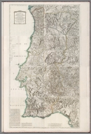
Full Title
Mapa General Del Reyno De Portugal : Comprehende Sus Provincias, Corregiementos, Oidorias, Proveedurias, Concejos, Cotos &c. ... Por Don Tomas Lopez, Geografo de los Dominos de S.M. ... Madrid ano de 1778. (to accompany) Atlas geografico de Espana ... por Don Tomas Lopez ... Tomo Primero. Ano 1810.
List No
11510.120
Note
1 map on 8 sheets. Engraved outline hand colored map with title carthouche. Shows administrative divisions, major cities, towns, villages, landmarks, public buildings, roads, rivers, canals, forests and mountains. Relief shown pictorially. Depth shown by soundings. Prime meridian is Tenerife. Includes explanation to symbols, descriptive text,and notes.
Author
Lopez de Vargas Machuca, Tomas (1730-1802)
Full Title
Mapa General Del Reyno De Portugal : Comprehende Sus Provincias, Corregiementos, Oidorias, Proveedurias, Concejos, Cotos &c. ... Por Don Tomas Lopez, Geografo de los Dominos de S.M. ... Madrid ano de 1778. (to accompany) Atlas geografico de Espana ... por Don Tomas Lopez ... Tomo Primero. Ano 1810.
List No
11510.121
Note
1 map on 8 sheets. Engraved outline hand colored map with title carthouche. Shows administrative divisions, major cities, towns, villages, landmarks, public buildings, roads, rivers, canals, forests and mountains. Relief shown pictorially. Depth shown by soundings. Prime meridian is Tenerife. Includes explanation to symbols, descriptive text,and notes.
Author
Lopez de Vargas Machuca, Tomas (1730-1802)
Full Title
Mapa General Del Reyno De Portugal : Comprehende Sus Provincias, Corregiementos, Oidorias, Proveedurias, Concejos, Cotos &c. ... Por Don Tomas Lopez, Geografo de los Dominos de S.M. ... Madrid ano de 1778. (to accompany) Atlas geografico de Espana ... por Don Tomas Lopez ... Tomo Primero. Ano 1810.
List No
11510.122
Note
1 map on 8 sheets. Engraved outline hand colored map with title carthouche. Shows administrative divisions, major cities, towns, villages, landmarks, public buildings, roads, rivers, canals, forests and mountains. Relief shown pictorially. Depth shown by soundings. Prime meridian is Tenerife. Includes explanation to symbols, descriptive text,and notes.
Author
Lopez de Vargas Machuca, Tomas (1730-1802)
Full Title
Mapa General Del Reyno De Portugal : Comprehende Sus Provincias, Corregiementos, Oidorias, Proveedurias, Concejos, Cotos &c. ... Por Don Tomas Lopez, Geografo de los Dominos de S.M. ... Madrid ano de 1778. (to accompany) Atlas geografico de Espana ... por Don Tomas Lopez ... Tomo Primero. Ano 1810.
List No
11510.123
Note
1 map on 8 sheets. Engraved outline hand colored map with title carthouche. Shows administrative divisions, major cities, towns, villages, landmarks, public buildings, roads, rivers, canals, forests and mountains. Relief shown pictorially. Depth shown by soundings. Prime meridian is Tenerife. Includes explanation to symbols, descriptive text,and notes.
Author
Lopez de Vargas Machuca, Tomas (1730-1802)
Full Title
Mapa General Del Reyno De Portugal : Comprehende Sus Provincias, Corregiementos, Oidorias, Proveedurias, Concejos, Cotos &c. ... Por Don Tomas Lopez, Geografo de los Dominos de S.M. ... Madrid ano de 1778. (to accompany) Atlas geografico de Espana ... por Don Tomas Lopez ... Tomo Primero. Ano 1810.
List No
11510.124
Note
1 map on 8 sheets. Engraved outline hand colored map with title carthouche. Shows administrative divisions, major cities, towns, villages, landmarks, public buildings, roads, rivers, canals, forests and mountains. Relief shown pictorially. Depth shown by soundings. Prime meridian is Tenerife. Includes explanation to symbols, descriptive text,and notes.
Author
Lopez de Vargas Machuca, Tomas (1730-1802)
Full Title
Mapa General Del Reyno De Portugal : Comprehende Sus Provincias, Corregiementos, Oidorias, Proveedurias, Concejos, Cotos &c. ... Por Don Tomas Lopez, Geografo de los Dominos de S.M. ... Madrid ano de 1778. (to accompany) Atlas geografico de Espana ... por Don Tomas Lopez ... Tomo Primero. Ano 1810.
List No
11510.125
Note
1 map on 8 sheets. Engraved outline hand colored map with title carthouche. Shows administrative divisions, major cities, towns, villages, landmarks, public buildings, roads, rivers, canals, forests and mountains. Relief shown pictorially. Depth shown by soundings. Prime meridian is Tenerife. Includes explanation to symbols, descriptive text,and notes.
Author
Lopez de Vargas Machuca, Tomas (1730-1802)
Full Title
Mapa General Del Reyno De Portugal : Comprehende Sus Provincias, Corregiementos, Oidorias, Proveedurias, Concejos, Cotos &c. ... Por Don Tomas Lopez, Geografo de los Dominos de S.M. ... Madrid ano de 1778. (to accompany) Atlas geografico de Espana ... por Don Tomas Lopez ... Tomo Primero. Ano 1810.
List No
11510.126
Note
1 map on 8 sheets. Engraved outline hand colored map with title carthouche. Shows administrative divisions, major cities, towns, villages, landmarks, public buildings, roads, rivers, canals, forests and mountains. Relief shown pictorially. Depth shown by soundings. Prime meridian is Tenerife. Includes explanation to symbols, descriptive text,and notes.
Author
Lopez de Vargas Machuca, Tomas (1730-1802)
Full Title
Mapa General Del Reyno De Portugal : Comprehende Sus Provincias, Corregiementos, Oidorias, Proveedurias, Concejos, Cotos &c. ... Por Don Tomas Lopez, Geografo de los Dominos de S.M. ... Madrid ano de 1778. (to accompany) Atlas geografico de Espana ... por Don Tomas Lopez ... Tomo Primero. Ano 1810.
List No
11510.127
Note
1 map on 8 sheets. Engraved outline hand colored map with title carthouche. Shows administrative divisions, major cities, towns, villages, landmarks, public buildings, roads, rivers, canals, forests and mountains. Relief shown pictorially. Depth shown by soundings. Prime meridian is Tenerife. Includes explanation to symbols, descriptive text,and notes.
Author
Lopez de Vargas Machuca, Tomas (1730-1802)
Full Title
(Composite map) Mapa General Del Reyno De Portugal : Comprehende Sus Provincias, Corregiementos, Oidorias, Proveedurias, Concejos, Cotos &c. ... Por Don Tomas Lopez, Geografo de los Dominos de S.M. ... Madrid ano de 1778. (to accompany) Atlas geografico de Espana ... por Don Tomas Lopez ... Tomo Primero. Ano 1810.
List No
11510.128
Note
Composite map of Portugal, sheets 91-98. 1 map on 8 sheets. Engraved outline hand colored map with title carthouche. Shows administrative divisions, major cities, towns, villages, landmarks, public buildings, roads, rivers, canals, forests and mountains. Relief shown pictorially. Depth shown by soundings. Prime meridian is Tenerife. Includes explanation to symbols, descriptive text,and notes.
Author
[Lubin, Eilhard (1565-1621), Geelkercken, Nicolaes van]
Full Title
Nova illustrissimi principatus Pomeraniae descriptio cum adjuncta Principum genealogia et Principum veris et potiorum Urbium imaginibus et Nobilium insignibus. N. Geilkerckius sculpsit. [With] Pomeraniae et rerum in ea memorabilium brevis descriptio E. Lubini.
List No
11511.001
Note
Large and impressive outline colored copperplate engraving map of Pomerania on 12 sheets, 42x54 or smaller, by Eilhard Lubin, Professor at the University of Rostock. In 1610 he was asked by Philipp II, the Duke of Pomerania to create a large scale map of the geography and history of the duchy. In 1612 map was completed, it was decorated with 49 town views, and coat of arms of the noble families. In 1618 the Dutch engraver Nicolas van Geelkercken, engraved the copperplates in Amsterdam, and a small number of sheets were printed. The plates disappeared in the thirty years war and were rediscovered by the historian Johann Carl Conard Oelrichs in 1758. The map shows 49 town views on the border, the family tree of the house of Griffins, dukes of Pomerania, with 157 names and small portraits, a small family tree of the house of Rugen, 5 large portraits of living dukes of different parts of Pomerania, and on the lower middle left sheet probably the portrait of Lubin himself. The map shows towns and villages, landmarks, churches, forest, rivers and mountains. Relief is shown pictorially. Lubin's Pomerania remained the most accurate map of the region from its inception in 1618 until the Prussian topographical survey of the eighteenth century. The map is extraordinary in the way that it combines the "mapping" of the history of the ruling families with the mapping of the topography of Pomerania.
Author
[Lubin, Eilhard (1565-1621), Geelkercken, Nicolaes van]
Full Title
Nova illustrissimi principatus Pomeraniae descriptio cum adjuncta Principum genealogia et Principum veris et potiorum Urbium imaginibus et Nobilium insignibus. N. Geilkerckius sculpsit. [With] Pomeraniae et rerum in ea memorabilium brevis descriptio E. Lubini.
List No
11511.002
Note
Large and impressive outline colored copperplate engraving map of Pomerania on 12 sheets, 42x54 or smaller, by Eilhard Lubin, Professor at the University of Rostock. In 1610 he was asked by Philipp II, the Duke of Pomerania to create a large scale map of the geography and history of the duchy. In 1612 map was completed, it was decorated with 49 town views, and coat of arms of the noble families. In 1618 the Dutch engraver Nicolas van Geelkercken, engraved the copperplates in Amsterdam, and a small number of sheets were printed. The plates disappeared in the thirty years war and were rediscovered by the historian Johann Carl Conard Oelrichs in 1758. The map shows 49 town views on the border, the family tree of the house of Griffins, dukes of Pomerania, with 157 names and small portraits, a small family tree of the house of Rugen, 5 large portraits of living dukes of different parts of Pomerania, and on the lower middle left sheet probably the portrait of Lubin himself. The map shows towns and villages, landmarks, churches, forest, rivers and mountains. Relief is shown pictorially. Lubin's Pomerania remained the most accurate map of the region from its inception in 1618 until the Prussian topographical survey of the eighteenth century. The map is extraordinary in the way that it combines the "mapping" of the history of the ruling families with the mapping of the topography of Pomerania.
Author
[Lubin, Eilhard (1565-1621), Geelkercken, Nicolaes van]
Full Title
Nova illustrissimi principatus Pomeraniae descriptio cum adjuncta Principum genealogia et Principum veris et potiorum Urbium imaginibus et Nobilium insignibus. N. Geilkerckius sculpsit. [With] Pomeraniae et rerum in ea memorabilium brevis descriptio E. Lubini.
List No
11511.003
Note
Large and impressive outline colored copperplate engraving map of Pomerania on 12 sheets, 42x54 or smaller, by Eilhard Lubin, Professor at the University of Rostock. In 1610 he was asked by Philipp II, the Duke of Pomerania to create a large scale map of the geography and history of the duchy. In 1612 map was completed, it was decorated with 49 town views, and coat of arms of the noble families. In 1618 the Dutch engraver Nicolas van Geelkercken, engraved the copperplates in Amsterdam, and a small number of sheets were printed. The plates disappeared in the thirty years war and were rediscovered by the historian Johann Carl Conard Oelrichs in 1758. The map shows 49 town views on the border, the family tree of the house of Griffins, dukes of Pomerania, with 157 names and small portraits, a small family tree of the house of Rugen, 5 large portraits of living dukes of different parts of Pomerania, and on the lower middle left sheet probably the portrait of Lubin himself. The map shows towns and villages, landmarks, churches, forest, rivers and mountains. Relief is shown pictorially. Lubin's Pomerania remained the most accurate map of the region from its inception in 1618 until the Prussian topographical survey of the eighteenth century. The map is extraordinary in the way that it combines the "mapping" of the history of the ruling families with the mapping of the topography of Pomerania.
Author
[Lubin, Eilhard (1565-1621), Geelkercken, Nicolaes van]
Full Title
Nova illustrissimi principatus Pomeraniae descriptio cum adjuncta Principum genealogia et Principum veris et potiorum Urbium imaginibus et Nobilium insignibus. N. Geilkerckius sculpsit. [With] Pomeraniae et rerum in ea memorabilium brevis descriptio E. Lubini.
List No
11511.004
Note
Large and impressive outline colored copperplate engraving map of Pomerania on 12 sheets, 42x54 or smaller, by Eilhard Lubin, Professor at the University of Rostock. In 1610 he was asked by Philipp II, the Duke of Pomerania to create a large scale map of the geography and history of the duchy. In 1612 map was completed, it was decorated with 49 town views, and coat of arms of the noble families. In 1618 the Dutch engraver Nicolas van Geelkercken, engraved the copperplates in Amsterdam, and a small number of sheets were printed. The plates disappeared in the thirty years war and were rediscovered by the historian Johann Carl Conard Oelrichs in 1758. The map shows 49 town views on the border, the family tree of the house of Griffins, dukes of Pomerania, with 157 names and small portraits, a small family tree of the house of Rugen, 5 large portraits of living dukes of different parts of Pomerania, and on the lower middle left sheet probably the portrait of Lubin himself. The map shows towns and villages, landmarks, churches, forest, rivers and mountains. Relief is shown pictorially. Lubin's Pomerania remained the most accurate map of the region from its inception in 1618 until the Prussian topographical survey of the eighteenth century. The map is extraordinary in the way that it combines the "mapping" of the history of the ruling families with the mapping of the topography of Pomerania.
Author
[Lubin, Eilhard (1565-1621), Geelkercken, Nicolaes van]
Full Title
Nova illustrissimi principatus Pomeraniae descriptio cum adjuncta Principum genealogia et Principum veris et potiorum Urbium imaginibus et Nobilium insignibus. N. Geilkerckius sculpsit. [With] Pomeraniae et rerum in ea memorabilium brevis descriptio E. Lubini.
List No
11511.005
Note
Large and impressive outline colored copperplate engraving map of Pomerania on 12 sheets, 42x54 or smaller, by Eilhard Lubin, Professor at the University of Rostock. In 1610 he was asked by Philipp II, the Duke of Pomerania to create a large scale map of the geography and history of the duchy. In 1612 map was completed, it was decorated with 49 town views, and coat of arms of the noble families. In 1618 the Dutch engraver Nicolas van Geelkercken, engraved the copperplates in Amsterdam, and a small number of sheets were printed. The plates disappeared in the thirty years war and were rediscovered by the historian Johann Carl Conard Oelrichs in 1758. The map shows 49 town views on the border, the family tree of the house of Griffins, dukes of Pomerania, with 157 names and small portraits, a small family tree of the house of Rugen, 5 large portraits of living dukes of different parts of Pomerania, and on the lower middle left sheet probably the portrait of Lubin himself. The map shows towns and villages, landmarks, churches, forest, rivers and mountains. Relief is shown pictorially. Lubin's Pomerania remained the most accurate map of the region from its inception in 1618 until the Prussian topographical survey of the eighteenth century. The map is extraordinary in the way that it combines the "mapping" of the history of the ruling families with the mapping of the topography of Pomerania.
|