|
Author
[Merian, Matthaeus (1593-1650), Zeiller, Martin (1589-1661)]
Full Title
Langen Schwalbach
List No
16210.093
Note
Date estimated. Dimensions are sheet size.
Author
[Merian, Matthaeus (1593-1650), Zeiller, Martin (1589-1661)]
Full Title
Schotten (with) Sigen (with) Text: Topographia Hassiæ et regionum vicinarum
List No
16210.097
Note
Date estimated. Dimensions are sheet size.
Author
[Merian, Matthaeus (1593-1650), Zeiller, Martin (1589-1661)]
Full Title
Sontra (with) Schwartzenborn (with) Stauffenburg (with) Text: Topographia Hassiæ et regionum vicinarum
List No
16210.098
Note
Date estimated. Dimensions are sheet size.
Author
[Merian, Matthaeus (1593-1650), Zeiller, Martin (1589-1661)]
Full Title
Treisa (with) Vach (with) Text: Topographia Hassiæ et regionum vicinarum
List No
16210.101
Note
Date estimated. Dimensions are sheet size.
Author
[Merian, Matthaeus (1593-1650), Zeiller, Martin (1589-1661)]
Full Title
Topographia Hassiæ et regionum vicinarum : das ist, Beschreibung der vornẽbsten Stätte vnd Plätze in Hessen vnd den benachbahrten Landtschaften als Buchen, Nassau, Betteraw, Westerwaldt, Wittgenstein, Lohngaw, vnd andern
List No
16210.103
Note
Date estimated. Dimensions are sheet size.
Author
[Merian, Matthaeus (1593-1650), Zeiller, Martin (1589-1661)]
Full Title
Das Schloß zu Weilburg (with) Weilburg
List No
16210.104
Note
Date estimated. Dimensions are sheet size.
Author
[Merian, Matthaeus (1593-1650), Zeiller, Martin (1589-1661)]
Full Title
Wetzlar.
List No
16210.105
Note
Date estimated. Dimensions are sheet size.
Author
[Merian, Matthaeus (1593-1650), Zeiller, Martin (1589-1661)]
Full Title
Wiesbaden
List No
16210.108
Note
Date estimated. Dimensions are sheet size.
Author
[Merian, Matthaeus (1593-1650), Zeiller, Martin (1589-1661)]
Full Title
Waldeck with) Wetter (with) Herrenberg (with) Text: Topographia Hassiæ et regionum vicinarum
List No
16210.109
Note
Date estimated. Dimensions are sheet size.
Author
[Merian, Matthaeus (1593-1650), Zeiller, Martin (1589-1661)]
Full Title
Geiselwerder (with) Sabbaburg (with) Text: Topographia Hassiæ et regionum vicinarum
List No
16210.110
Note
Date estimated. Dimensions are sheet size.
Author
[Merian, Matthaeus (1593-1650), Zeiller, Martin (1589-1661)]
Full Title
Ziegenhain (with) Grundriss der Vestung Ziegenhain (with) Text: Topographia Hassiæ et regionum vicinarum
List No
16210.111
Note
Date estimated. Dimensions are sheet size.
Author
[Merian, Matthaeus (1593-1650), Zeiller, Martin (1589-1661)]
Full Title
Ziegenberg (with) Ludwigstein (with) Zwingenberg (with) Lichtenberg (with) Text: Topographia Hassiæ et regionum vicinarum
List No
16210.112
Note
Date estimated. Dimensions are sheet size.
Author
Magnus, Charles
Full Title
[Map of 100 miles around Richmond].
List No
16186.000
Note
See our 3969.000 for the Magnus source map.
Author
[Darkes, Giles, Hisotry of Bath Research Group]
Full Title
(Covers to) An Historical Map of Bath, Medieval, Stuart & Georgian City. Town & City Historical Maps No. 17.
List No
16181.001
Author
[Darkes, Giles, Hisotry of Bath Research Group]
Full Title
An Historical Map of Bath, Medieval, Stuart & Georgian City. Town & City Historical Maps No. 17.
List No
16181.002
Author
[Darkes, Giles, Hisotry of Bath Research Group]
Full Title
(Text page to) An Historical Map of Bath, Medieval, Stuart & Georgian City. Town & City Historical Maps No. 17.
List No
16181.003
Author
United States. Post Office Department
Full Title
Post Route Map Alaska ... May 15, 1958.
List No
16198.000
Author
Berann, Heinrich Caesar (1915-1999)
Full Title
(Germany)
List No
16200.000
Note
Studio Berann Vielkind
Author
[Charles, Andre Basset, Aristide, V. Monin, Perrot, Michel]
Full Title
(Covers to) Atlas of Tableau Comparatifs
List No
16183.001
Note
Date estimated
Author
Monin, C.V.
Full Title
Tableau Comparatif De La Hauteur Des Montagnes de la longuer du Cours des Fleuves et de l'Elevation des Principales Chutes d'Eau Dans Les Cinq Parties Du Monde
List No
16183.002
Note
Date estimated
Author
[Charles, Andre Basset, Perrot, Michel]
Full Title
Tableau Pittoresque Des Merveilles De La Nature Par Perrot, Ingenieur Geographe
List No
16183.003
Note
Date estimated
Author
Perrot, Michel
Full Title
Tableau comparatif de la Hauteur des Principaux Monuments
List No
16183.004
Note
Date estimated
Author
[Charles, Andre Basset, Perrot, Michel]
Full Title
Tableau Comparatif des Races et des Costumes des Principaux des Cinq Parties du Monde
List No
16183.005
Note
Date estimated
Author
[Charles, Andre Basset, Perrot, Michel]
Full Title
Tableau Comparatif des Femmes des Cinq Parties du Monde... et Leurs Costumes Nationaux (
List No
16183.006
Note
Date estimated
Author
Bierut, Bolesław, 1892-1956
Full Title
(Covers to) Шестилетний план восстановления Варшавы : Графическое оформление, диаграммы, планы и макеты выполнены на основе материалов и проектов бюро по планированию Варшавы.
List No
14513.001
Note
Covers to Шестилетний план восстановления Варшавы : Графическое оформление, диаграммы, планы и макеты выполнены на основе материалов и проектов бюро по планированию Варшавы. Title translates to: Six-year plan for the reconstruction of Warsaw : Graphic design, diagrams, plans and layouts based on materials and projects of the Warsaw Planning Office. Sewn binding. Bound in board with cream colored fabric, gilt cover and spine title each with decorative borders. Emblem at the bottom of the spine is that of the publisher, Książka i Wiedza, Warsaw.
Author
Bierut, Bolesław, 1892-1956
Full Title
Plan de la ville de Varsovie dedie a S.M. Auguste III roi de Pologne electeur de saxe & leve par ordre de S.E.M.le comte Bielinski grand marechal de la coronne.
List No
14513.002
Note
Map representing Warsaw with 18 views representing notable buildings and a profile of the city. Endpapers to Шестилетний план восстановления Варшавы. Map shows buildings, roads, drainage, and islands. Includes a compass rose with north oriented toward bottom right of sheet, and a bar scale; no scale of measurement given. Title translates to: Map of the city of Warsaw dedicated to H.M. Augustus III, king of Poland elector of Saxony & raised by order of H.E.M. Count Bielinski grand marshal of the crown. Printed in black and white. Together, map and views are 32 x 47 cm, on double sheet 33 x 49 cm.
Author
Bierut, Bolesław, 1892-1956
Full Title
(Title Page to): Болеслав Берут. Шестилетний план восстановления Варшавы : Графическое оформление, диаграммы, планы и макеты выполнены на основе материалов и проектов бюро по планированию Варшавы. Ксенжка и Ведза.
List No
14513.004
Note
Title page to Болеслав Берут. Шестилетний план восстановления Варшавы : Графическое оформление, диаграммы, планы и макеты выполнены на основе материалов и проектов бюро по планированию Варшавы. Ксенжка и Ведза. Title translates to: Bolesław Bierut. Six-year plan for the rebuilding of Warsaw : Graphic design, diagrams, plans and layouts based on materials and projects of the Warsaw planning office. Ksenzka and Wedza. Includes the emblem of the publisher, Książka i Wiedza, Warsaw. Printed in color. (Page number inferred.)
Author
Bierut, Bolesław, 1892-1956
Full Title
Варшавская конференция ПОРП 3 июля 1949 г.
List No
14513.007
Note
View with two maps representing Warsaw. Title translates to: Warsaw Conference of the PUWP July 3, 1949. Printed in black. Together, view and maps are 33 x 24 cm, on sheet 33 x 25 cm.
Author
Bierut, Bolesław, 1892-1956
Full Title
Рост населения Варшавы в 1945 году.
List No
14513.035
Note
Map representing population growth in Warsaw through 1945. Title translates to: Warsaw population growth in 1945. Map shows roads, buildings, and drainage. With a chart representing population growth overlaid on top. Printed in black. Map is 18 x 18 cm, on sheet 33 x 25 cm.
Author
Bierut, Bolesław, 1892-1956
Full Title
No.1. Варшава — центральные районы.
List No
14513.041
Note
Map representing Warsaw. Title translates to: Warsaw - central areas. Map shows roads, districts, and drainage. Includes a legend, a compass rose with north oriented toward top of sheet, and a bar scale given in meters. Printed in color. Map is 33 x 24 cm, on sheet 33 x 24cm.
Author
Bierut, Bolesław, 1892-1956
Full Title
No. 2. Варшава — шестилетний план центральных районов.
List No
14513.042
Note
Map representing Warsaw. Title translates to: Warsaw - six-year plan for the central regions. Map shows roads, districts, and drainage. Includes a legend, a compass rose with north oriented toward top of sheet, and a bar scale given in meters. Printed in color. Map is 33 x 24 cm, on sheet 33 x 24 cm.
Author
Bierut, Bolesław, 1892-1956
Full Title
Рост населения Варшавы в годы 1921-1939.
List No
14513.043
Note
Graph representing the population growth of Warsaw from 1921-1939. Population represented by figures divided into three periods. Printed in color. Graph is 18 x 18 cm, on sheet 33 x 25 cm.
Author
Bierut, Bolesław, 1892-1956
Full Title
[Map of part of central Warsaw.]
List No
14513.047
Note
Map representing part of central Warsaw. Caption of map translates to: Pre-war development of central areas. Maximum profit for speculators, worst conditions for the population. Map shows select roads and building sites. Printed in black. Map is 33 x 12 cm, on sheet 33 x 25 cm.
Author
Bierut, Bolesław, 1892-1956
Full Title
No. 3. Довоенная Варшава и рабочие районы : Районы с канализационной сетью.
List No
14513.053
Note
Map representing Warsaw. Title translates to: Pre-war Warsaw and working-class areas: Areas with a sewer network. Map shows roads, districts, and drainage. Includes a legend, a compass rose with north oriented toward top of sheet, and a bar scale given in meters. Printed in color. Map is 33 x 25 cm, on sheet 33 x 25 cm.
Author
Bierut, Bolesław, 1892-1956
Full Title
No. 4. Довоенная Варшава — промышленность.
List No
14513.079
Note
Map representing Warsaw. Title translates to: Pre-war Warsaw - industry. Map shows roads, districts, and drainage. Includes a legend, a compass rose with north oriented toward top of sheet, and a bar scale given in meters. Printed in color. Map is 33 x 24 cm, on double sheet 33 x 24 cm.
Author
Bierut, Bolesław, 1892-1956
Full Title
No. 5. Варшава промышленность в шестилетнем плане.
List No
14513.080
Note
Map representing Warsaw. Title translates to: Warsaw industry in the six-year plan. Map shows roads, districts, and drainage. Includes a legend, a compass rose with north oriented toward top of sheet, and a bar scale given in meters. Printed in color. Map is 33 x 24 cm, on sheet 33 x 24 cm.
Author
Bierut, Bolesław, 1892-1956
Full Title
Кубатура промышленных предприятий в шестилетнем плане.
List No
14513.081
Note
Diagram representing the cubic capacity of industrial enterprises in the six-year plan. The caption translates to: If we were to build a factory building of this cubic capacity, 12 floors high, i.e. 40 meters, it would occupy a surface area of 14 hectares and cover Teatralnaya Square along with the adjacent streets of the city center. Printed in black. Diagram is 23 x 18 cm, on sheet 33 x 25 cm.
Author
Bierut, Bolesław, 1892-1956
Full Title
No. 6. Варшава — жилища и промышленность в шестилетнем плане.
List No
14513.128
Note
Map representing Warsaw. Title of map translates to: Warsaw - housing and industry in the six-year plan. Map shows roads, districts, and drainage. Includes a legend, a compass rose with north oriented toward top of sheet, and a bar scale given in meters. Printed in color. Map is 33 x 25 cm, on sheet 33 x 25 cm.
Author
Bierut, Bolesław, 1892-1956
Full Title
No.7. Варшава жилые поселки зор на маршалковской улице и трассе в - з.
List No
14513.132
Note
Map representing Warsaw. Title of map translates to: Warsaw residential settlements Zor on Marszałkowska Street and the V-Z highway. Map shows roads, districts, and drainage. Includes a legend, a compass rose with north oriented toward top of sheet, and a bar scale given in meters. Printed in color. Map is 33 x 25 cm, on sheet 33 x 25 cm.
Author
Bierut, Bolesław, 1892-1956
Full Title
No. 8. Варшава — жилые поселки зор в шестилетнем плане.
List No
14513.133
Note
Map representing Warsaw. Title of map translates to: No. 8. Warsaw - residential settlements in the six-year plan. Map shows roads, districts, and drainage. Includes a legend, a compass rose with north oriented toward top of sheet, and a bar scale given in meters. Printed in color. Map is 33 x 24 cm, on sheet 33 x 49 cm.
Author
Bierut, Bolesław, 1892-1956
Full Title
2. Zabytkowe mury obronne 1949, Древние оборонные стены 1949.
List No
14513.136
Note
Two maps on the left page representing Warsaw in 1938 and 1955 with text, with a view representing a wall on the facing page. The facing page folds out to reveal a view. Maps show roads and buildings. The title is in Polish and Russian, both translate to: Ancient defensive walls 1949. Printed in black. Together, plans and view are 25 x 40 cm, on double sheet 33 x 49 cm. (Page number inferred.)
Author
Bierut, Bolesław, 1892-1956
Full Title
No. 9. Довоенная Варшава — коммуникации.
List No
14513.155
Note
Map representing Warsaw. Title translates to: Pre-war Warsaw - communications. Map shows roads, districts, and drainage. Includes a legend, a compass rose with north oriented toward top of sheet, and a bar scale given in meters. Printed in color. Map is 33 x 25 cm, on double sheet 33 x 25 cm.
Author
Bierut, Bolesław, 1892-1956
Full Title
No. 10. Варшава — коммуникации в 1945 году.
List No
14513.156
Note
Map representing Warsaw. Title translates to: No. 10. Warsaw - communications in 1945. Map shows roads, districts, and drainage. Includes a legend, a compass rose with north oriented toward top of sheet, and a bar scale given in meters. Printed in color. Map is 33 x 24 cm, on sheet 33 x 49 cm.
Author
Bierut, Bolesław, 1892-1956
Full Title
No. 11. Варшава - коммуникации в шестилетнем плане.
List No
14513.157
Note
Map representing Warsaw. Title translates to: Warsaw - communications in the six-year plan. Map shows roads, districts, and drainage. Includes a legend, a compass rose with north oriented toward top of sheet, and a bar scale given in meters. Printed in color. Map is 33 x 24 cm, on sheet 33 x 49 cm.
Author
Bierut, Bolesław, 1892-1956
Full Title
(Text Page to) Метро.
List No
14513.160
Note
A map representing central Warsaw on left page, with text on the facing page. Title translates to: Metro. Map shows roads and drainage. The text translates to: The main investment for urban transport in Warsaw will also begin - the construction of a metro, i.e. a high-speed urban railway, the first, northern branch of which will connect the northern districts with the center, from Bielany to the Main Station and will pass under Marszałkowska Street. Printed in color. Together, map and text are 33 x 45 cm, on double sheet 33 x 49 cm.
Author
Bierut, Bolesław, 1892-1956
Full Title
No. 12. План центра города.
List No
14513.169
Note
Map representing Warsaw. Title translates to: Plan of the city center. Map shows roads, buildings, and drainage. Includes a legend, a compass rose with north oriented toward top of sheet, and a bar scale given in meters. Printed in color. Map is 33 x 24 cm, on sheet 33 x 25 cm.
Author
Bierut, Bolesław, 1892-1956
Full Title
No. 13. Центр Города в шестилетнем плане.
List No
14513.170
Note
Map representing Warsaw. Title translates to: City center in the six-year plan. Map shows roads, buildings, and drainage. Includes a legend, a compass rose with north oriented toward top of sheet, and a bar scale given in meters. Printed in color. Map is 33 x 24 cm, on sheet 33 x 24 cm.
Author
Bierut, Bolesław, 1892-1956
Full Title
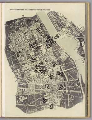
Ориентационный план перспективных рисунков.
List No
14513.211
Note
Map representing Warsaw. Title of map translates to: Orientation plan of perspective drawings. Map shows roads, buildings, and drainage. Printed in black. Map is 30 x 24 cm, on sheet 33 x 24 cm..
Author
Bierut, Bolesław, 1892-1956
Full Title
No. 14. Довоенная Варшава зеленые насаждения.
List No
14513.216
Note
Map representing Warsaw. Title translates to: Pre-war Warsaw green spaces. Map shows roads, parks, and drainage. Includes a legend, a compass rose with north oriented toward top of sheet, and a bar scale given in meters. Printed in color. Map is 33 x 24 cm, on sheet 33 x 24 cm.
Author
Bierut, Bolesław, 1892-1956
Full Title
No. 15. Варшава — зеленые насаждения в шестилетнем плане.
List No
14513.217
Note
Map representing Warsaw. Title translates to: Warsaw - green spaces in the six-year plan. Map shows roads, parks, and drainage. Includes a legend, a compass rose with north oriented toward top of sheet, and a bar scale given in meters. Printed in color. Map is 33 x 24 cm, on sheet 33 x 24 cm.
|


![[Map of 100 miles around Richmond].](https://www.davidrumsey.com/rumsey/Size1/RUMSEY~8~1/213/16186000.jpg)


![[Map of part of central Warsaw.]](https://www.davidrumsey.com/rumsey/Size1/RUMSEY~8~1/213/14513047.jpg)