|
Author
Stieler, Adolf
Full Title
(Contents Page to) Hand Atlas Uber Alle Theile Der Erde nach dem neuesten Zustande Und Uber Das Weltgebaude. Herausgegebenn von Adolf Stieler, berbeitet von Demselben, so wie von C.G. Reichard, H. Hubbe, F.v. Stulpnagel, H. Berghaus u. I.C. Bar. Gotha bei Justus Perthes. (title page only) gez. v. Bar. gest. v. Edler in Gotha.
List No
10777.001
Note
List 63 maps and shows the correspondence to the prior edition of 50 maps.
Author
Stieler, Adolf
Full Title
(Title Page to) Hand Atlas Uber Alle Theile Der Erde nach dem neuesten Zustande Und Uber Das Weltgebaude. Herausgegebenn von Adolf Stieler, berbeitet von Demselben, so wie von C.G. Reichard, H. Hubbe, F.v. Stulpnagel, H. Berghaus u. I.C. Bar. Gotha bei Justus Perthes. (title page only) gez. v. Bar. gest. v. Edler in Gotha.
List No
10777.002
Note
Dated 1831 in the map inset title.
Author
Stieler, Adolf
Full Title
Das Planeten System. Entworfen v. Ad. St. 1823. Edler, sc. Gotha. (on upper right margin) Stieler's Hand Atlas No. 4. (to accompany) Hand-Atlas uber alle Theile der Erde, nach dem neuesten Zustande und uber das Weltgebaude.
List No
10777.003
Note
Engraved chart of the solar system with the insets of the phases of the moon, Earth and Venus. Includes 2 tables and explanation.
Author
Stieler, Adolf
Full Title
Der Nordliche Gestirnte Himmel. Entw. u. gez. v. A. Stieler. Gest. v. L. Hess. (on upper right margin) Hand Atlas. No.5. (to accompany) Hand-Atlas uber alle Theile der Erde, nach dem neuesten Zustande und uber das Weltgebaude.
List No
10777.004
Note
Engraved star chart. Not dated so dated by atlas date.
Author
Stieler, Adolf
Full Title
Westliche Halbkugel. Entw. u. gez. v. C.G. Reichard. Gest. v. L. Hess. ( on upper right margin) Hand Atl. No. 6. (to accompany) Hand-Atlas uber alle Theile der Erde, nach dem neuesten Zustande und uber das Weltgebaude.
List No
10777.005
Note
Engraved outline map of Western hemisphere. Relief shown by hachures.
Author
Stieler, Adolf
Full Title
Ostliche Halbkugel. Entw. u. gez. v. C.G. Reichard. Gest. v. L. Hess. (on upper right margin) Hand Atl. No. 7. (to accompany) Hand-Atlas uber alle Theile der Erde, nach dem neuesten Zustande und uber das Weltgebaude.
List No
10777.006
Note
Engraved outline map of Eastern hemisphere. Relief shown by hachures.
Author
Stieler, Adolf
Full Title
Planiglob der Antipoden ; oder der grosten Entfernungen auf der erde, nach eigner idee entw. u. gez. v. A. Stieler 1816. Gest. v. L. Michaelis in Gotha. (on upper right margin) Hand Atlas No. 8. (to accompany) Hand-Atlas uber alle Theile der Erde, nach dem neuesten Zustande und uber das Weltgebaude. (with 4 insets).
List No
10777.007
Note
Engraved outline hand color map, with insets: Nordliche Halbkugel; Sudliche Halbkugel; Fur die grosste Masse Landes; Fur die grosste Masse Wassers. Relief shown by hachures. Includes note.
Author
Stieler, Adolf
Full Title
Planiglobe in Mercators Projection.
List No
10777.008
Author
Stieler, Adolf
Full Title
Polar-Karte enthaltend : die lander u. meere vom nord-pol bis 50 N.Br.u.weiter; mit der Ubersicht des Russischen Reichs in Eur. As. Am und des Brittischen Nord-America: entw. Neue Bearbeitung 1832. (on upper right margin) Stielers Hand Atlas No. 41b. (to accompany) Hand-Atlas uber alle Theile der Erde, nach dem neuesten Zustande und uber das Weltgebaude.
List No
10777.009
Note
First issued in 1816. Engraved hand colored outline map. Shows Canada, Alaska, northern Asia and northern Europe with north coast of Greenland undefined. Includes key indicating the unknown polar regions, the extent of drift ice, the northern tree line and extent of human occupation. Relief shown by hachure. Prime meridians are Greenwich and Ferro. New edition of 1832.
Author
Stieler, Adolf
Full Title
Die bekannteren Hohen uber der meeresflache in transprenten profilen; nach der geograph, Lage geordnet, mit Andentungdes zusammenhanges u. der Entfernung vom Auge, Ein Versuch v. Ad. St. 1822. Nachtrage 1828. (on upper right margin) Stielers Hand Atlas. No. 10. (to accompany) Hand-Atlas uber alle Theile der Erde, nach dem neuesten Zustande und uber das Weltgebaude.
List No
10777.010
Note
Three engraved hand color profiles, showing highest of mountains above the sea level.
Author
Stieler, Adolf
Full Title
(Covers to) Vorbemerkungen zu dem Hand-Atlas uber alle Theile der Erde, nach dem neuesten Zustande, und über das Weltgebäude, nebst einem geographischen Texte. Herausgegeben und gemeinschaftlich mit C.G. Reichard bearbeitet von Adolf Stieler.
List No
13403.001
Note
Covers to report and geographical text on the Stieler’s hand atlas.
Author
Stieler, Adolf
Full Title
(Title Page to) Vorbemerkungen zu dem Hand-Atlas uber alle Theile der Erde, nach dem neuesten Zustande, und über das Weltgebäude, nebst einem geographischen Texte. Herausgegeben und gemeinschaftlich mit C.G. Reichard bearbeitet von Adolf Stieler.
List No
13403.002
Note
Title page to report and geographical text on the Stieler’s hand atlas. At head of title "E 13".
Author
Stieler, Adolf
Full Title
(Text Page to) Vorbemerkungen zu dem Hand-Atlas uber alle Theile der Erde, nach dem neuesten Zustande, und über das Weltgebaude, nebst einem geographischen Texte. Herausgegeben und gemeinschaftlich mit C.G. Reichard bearbeitet von Adolf Stieler.
List No
13403.003
Note
Text, with directory of the plates in the atlas.
Author
Stieler, Adolf
Full Title
(Text Page to) Vorbemerkungen zu dem Hand-Atlas uber alle Theile der Erde, nach dem neuesten Zustande, und über das Weltgebaude, nebst einem geographischen Texte. Herausgegeben und gemeinschaftlich mit C.G. Reichard bearbeitet von Adolf Stieler.
List No
13403.004
Note
Continues directory. Classification of maps according to scale.
Author
Stieler, Adolf
Full Title
(Title and Index Page) Stieler's Hand-Atlas. Ausgabe in 44 Karten. Gotha: Justus Perthes.
List No
2207.002
Author
[Stieler, Adolf, Vogel, C.]
Full Title
(Composite Map) Deutsches Reich in 4 Blatten.
List No
2207.012
Author
[Stieler, Adolf, Vogel, C.]
Full Title
(Composite Map) Oesterreich_Ungarn in 4 Blaettern, Blatt 4.
List No
2207.019
Author
[Stieler, Adolf, Lueddecke, R.]
Full Title
(Composite Map) Afrika in 6 Blaetten.
List No
2207.040
Author
[Stieler, Adolf, Petermann, A., Lueddecke, R.]
Full Title
(Composite Map) West-Indien in 4 Blaettern, Bl.4.
List No
2207.050
Author
[Stieler, Adolf, Haack, H.]
Full Title
(Title Page) Stielers Hand-Atlas. 254 Haupt- und Nebenkarten in Kupferstich. Zehnte Auflage Hundertjahr - Ausgabe. Herausegeben unter Leitung von Prof. Dr. H. Haack, in Justus Perthes' Geogr. Anstalt. Gotha: Justus Perthes.
List No
12248.002
Author
[Stieler, Adolf, Haack, H.]
Full Title
5. Europa.
List No
12248.018
Author
[Stieler, Adolf, Haack, H.]
Full Title
6. Grossdeutsches Reich.
List No
12248.020
Author
Stieler, Adolf
Full Title
(Title Page) Stielers Hand-Atlas. 100 Karten in Kupferstich mit 162 Nebenkarten herausgegeben von Justus Perthes' Geographischer Anstalt in Gotha. Neunte, von Grund aus Neubearbeitete und Neugestochene auflage. Gotha: Justus Perthes. 1905.
List No
0961.003
Author
[Stieler, Adolf, Vogel, C.]
Full Title
(Composite Map) 9-12. Deutsches Reich in 4 Blaettern.
List No
0961.030
Author
[Stieler, Adolf, Scherrer,C., Habenicht, H.]
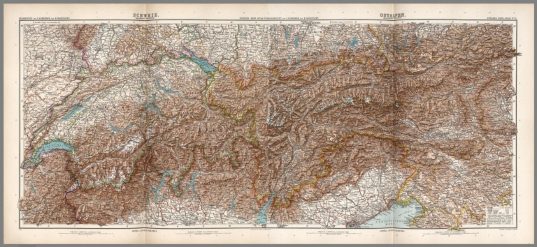
Full Title
(Composite Map) 14-15. Alpenlaender.
List No
0961.037
Author
[Stieler, Adolf, Vogel, C.]
Full Title
(Title Page) Stieler's Hand-Atlas. 100 Karten in Kupferstich mit 162 Nebenkarten Herausgegeben von Justus Perthes' Geographischer Anstalt in Gotha. Neunte, von Grund aus Neubearbeitete und Neugestochene Auflage. Achter Berichtigter Abdruck. Gotha: Justus Perthes. 1911.
List No
0962.003
Author
[Stieler, Adolf, Berghaus, H.]
Full Title
Nr. 3. Westliche und Oestliche Halbkugel ... von Habenicht. Hoehen und Tiefen der Erde.
List No
0962.011
Note
Includes 3 small world maps: water hemisphere, land hemisphere, and antipodes.
Author
[Stieler, Adolf, Berghaus, H.]
Full Title
Nr. 5. Nord - Polar - Karte.
List No
0962.015
Author
[Stieler, Adolf, Petermann, A., Habenicht, H.]
Full Title
Nr. 6. Sued-Polar-Karte ... von A. Petermann.
List No
0962.017
Author
Stieler, Adolf
Full Title
(Composite Map) Stielers Karte v. Deutschland in 25 Blatt.
List No
12099.029
Note
Date estimated.
Author
Stieler, Adolf
Full Title
(Composite of) Nos. XXI, XXVII, XXIX, XXXI, XXXII. Stieler's Hand-Atlas Deutschland ....
List No
2507.127
Note
Composite of five maps of parts of Germany.
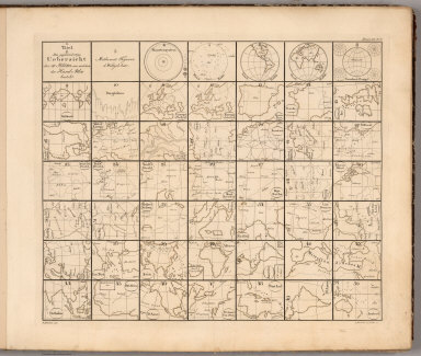
Author
Stieler, Adolf
Full Title
(Index Map) Die gegenwartige ubersicht der 50 Blatter aus welchen der Hand - Atlas besteh. A. Stieler del., L. Michaelis in Gotha sc. (on upper right margin) Hand Atl. No. 2 (to accompany) Hand-Atlas uber alle Theile der Erde, nach dem neuesten Zustande und uber das Weltgebaude.
List No
6830.003
Note
Unusual index map that shows the rough shape and projection for each of the original 50 maps of the atlas. Stieler was one of the first to use this technique for a visual index instead of listing the maps in text only. Zero or first edition of Stieler Atlas published 1817-1833 in three versions. 1817-23 (version 0.a), 1823-31 (version 0.b), 1831-33 (version 0.c). Publication went through ten editions from 1816 to 1944. This version published in 2 parts then augmented with two further supplementary installments, through 1833. Most maps have the year of first edition. This edition compromises 90 sheets, dated 1816-1835, including composite index map, and extraordinarily detailed maps and supplements. Maps are copper-plate engravings, hand colored in outline, mounted on cloth backing. Bound in marble papered, half leather covers with no title on cover. Inset map on title page: Gotha und Umgebung 1823 ; gest. v. Edler. Gez. v. Bar.
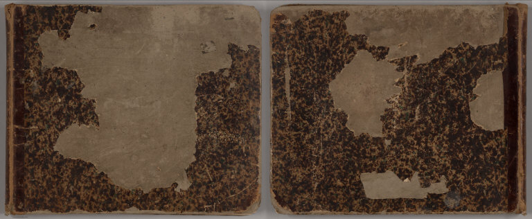
Author
Stieler, Adolf
Full Title
(Covers to) Hand Atlas Uber Alle Theile Der Erde Und Uber Das Weltgebaude. Erste Auscabe 1817, Jubel Auscabe 1867. Herausgegeben Von Adolf Stieler. Gotha Justus Perthes.
List No
0960.001
Note
Date estimated. Covers are half leather brown marbled paper covered boards with "Stieler, Hand-Atlas." stamped in gilt on the spine.
Author
Stieler, Adolf
Full Title
(Title Page) Hand Atlas Uber Alle Theile Der Erde Und Uber Das Weltgebaude. Erste Auscabe 1817 Jubel Auscabe 1867. Herausgegeben Von Adolf Stieler. Gotha Justus Perthes.
List No
0960.002
Author
[Mayr, C., Stieler, Adolf]
Full Title
Mayr's Alpenkarte I. No. 1. Karte der Alpen aus C. Mayr's Atlas der Alpenlander... 8 colorirte Blatter.
List No
0960.003
Note
One sheet of incomplete set.
Author
[Stieler, Adolf, Mayr, C.]
Full Title
Mayr's Alpenkarte I. No. 2. Karte der Alpen aus C. Mayr's Atlas der Alpenlander... 8 colorirte Blatter.
List No
0960.004
Note
One sheet of incomplete set.
Author
[Stieler, Adolf, Mayr, C.]
Full Title
Mayr's Alpenkarte I. No. 3. Karte der Alpen aus C. Mayr's Atlas der Alpenlander... 8 colorirte Blatter.
List No
0960.005
Note
One sheet of incomplete set.
Author
[Stieler, Adolf, Mayr, C.]
Full Title
(Composite of) Mayr's Alpenkarte 1 - 3 Karte der Alpen aus C. Mayr's Atlas der Alpenlander... 8 colorirte Blatter.
List No
0960.104
Note
Composite of 3 sheets of 5, an incomplete set.
Author
Stieler, Adolf
Full Title
Stieler's Hand-Atlas ... No. 4. Planeten_System der Sonne.
List No
0960.008
Note
Revision of 1825 edition.
Author
Stieler, Adolf
Full Title
Stieler's Hand-Atlas ... No. 5. Die sichtbare Seite der Mond-Oberfkache bey voller Belencla.
List No
0960.009
Author
Stieler, Adolf
Full Title
Stieler's Hand-Atlas ... No. 5a. Der Nordliche Stern. Himmel.
List No
0960.010
Author
Stieler, Adolf
Full Title
Stieler's Hand-Atlas ... No. 5b. Der Sudliche Stern. Himmel.
List No
0960.011
Author
Stieler, Adolf
Full Title
Stieler's Hand-Atlas ... No. 8. Planiglob der Antipoden.
List No
0960.012
Author
Stieler, Adolf
Full Title
Stieler's Hand-Atlas ... No. 8. Welt-Karte zur Ubersicht der Luft-Stromungen und der See-Wege.
List No
0960.013
Note
Revised from 1867 edition.
Author
Stieler, Adolf
Full Title
Stieler's Hand-Atlas ... No. 8. Welt-Karte zur Ubersicht der Meeres-Stromungen und der Schnellverkehrs.
List No
0960.014
Note
Revised from 1867 edition.
Author
Stieler, Adolf
Full Title
Stieler's Hand-Atlas ... No. 12. Nord-Atlantischer Ocean.
List No
0960.015
Note
Revised from 1867 and 1871 editions. Shows submarine and surface telegraph cables, routes of exploration, and marine bathymetry.
Author
Stieler, Adolf
Full Title
Stieler's Hand-Atlas ... No. 13b. Spanien und Portugal in IV Blattern.
List No
0960.016
Note
Revised from 1829 and 1839. One of four sheets.
Author
Stieler, Adolf
Full Title
Stieler's Hand-Atlas ... No. 13c. Spanien und Portugal in IV Blattern.
List No
0960.017
Note
Revised from 1829 and 1839. One of four sheets.
Author
Stieler, Adolf
Full Title
Stieler's Hand-Atlas ... No. 13d. Spanien und Portugal in IV Blattern. (insets) Lissbon. Madrid. Cadiz.
List No
0960.018
Note
Revised from 1829 and 1839. One of four sheets.
Author
Stieler, Adolf
Full Title
Stieler's Hand-Atlas ... No. 13e. Spanien und Portugal in IV Blattern.
List No
0960.019
Note
Revised from 1829 and 1839. One of four sheets.
|