|
Author
Spruner von Merz, Karl, 1803-1892
Full Title
Asia Minor, Syria, Cyprus, Creta & Insulae maris Aegaei. Gothae : Justus Perthes. C. Poppey sc. (to accompany) C. Spruneri atlas antiquus No. XV. Editio secunda ... Anno MDCCCLV (1855). (half title page) Dr. Karl von Spruner's Historisch-geographischer Hand-Atlas ... (insets) Hellspontus et Troas. (with) Ionia. (with) Campus Troiae.
List No
11676.022
Note
Outline hand colored map of Asia Minor. Shows political divisions, major cities and towns. Relief shown by hachures.
Author
Spruner von Merz, Karl, 1803-1892
Full Title
Armenia, Mesopotamia, Babylonia et Assyria, cum adiacentibus regionibus. Gothae : Justus Perthes. W. Alt sc. (to accompany) C. Spruneri atlas antiquus No. XVI. Editio secunda ... Anno MDCCCLV (1855). (half title page) Dr. Karl von Spruner's Historisch-geographischer Hand-Atlas ...
List No
11676.023
Note
Outline hand colored map of the region of present-day Armenia, Azerbaijan and eastern Turkey. Shows political divisions, major cities and towns. Relief shown by hachures.
Author
Spruner von Merz, Karl, 1803-1892
Full Title
Thracia, Macedonia, Illyricum, Moesia, Pannonia & Dacia. Gothae : Justus Perthes. Alt sc. (to accompany) C. Spruneri atlas antiquus No. XVII. Editio secunda ... Anno MDCCCLV (1855). (half title page) Dr. Karl von Spruner's Historisch-geographischer Hand-Atlas ... (inset) Macedonia.
List No
11676.024
Note
Outline hand colored map of the Roman provinces. Shows administrative boundaries, major cities and towns. Relief shown by hachures.
Author
Spruner von Merz, Karl, 1803-1892
Full Title
Palaestina a temporibus Maccabaeorum usque ad eversionem Hierosolymae. Gothae : Justus Perthes. W. Behrens sc. (to accompany) C. Spruneri atlas antiquus No. XVIII. Editio secunda ... Anno MDCCCLV (1855). (half title page) Dr. Karl von Spruner's Historisch-geographischer Hand-Atlas ... (insets) Hierosolyma tempore eversionis per Titum. (with) Palaestina tempore Judicum et Regum. (with) Hierosolyma, urbs & regio. (with) Tabula populorum secundum Mosem I,10.
List No
11676.025
Note
Outline hand colored map of Palestine. Shows political boundaries, major cities and towns. Relief shown by hachures.
Author
Spruner von Merz, Karl, 1803-1892
Full Title
India. Gothae : Justus Perthes. (to accompany) C. Spruneri atlas antiquus No.XIX. Editio secunda ... Anno MDCCCLV (1855). (half title page) Dr. Karl von Spruner's Historisch-geographischer Hand-Atlas ... (insets) India Ptolemaei. (with) India Eratosthenis. (with) Dachinabades et Taprobane.
List No
11676.026
Note
Outline hand colored map of India. Shows political boundaries, major cities and towns. Relief shown by hachures.
Author
[Sydow, Emil von., 1812-1873, Wagner, Hermann, 1840-1929]
Full Title
(Title Page to) Sydow-Wagners methodischer Schul-Atlas. Bearbeitet von H. Haack u. H. Lautensach. 23., von O. Stollt kartographisch durchgesehene Auflage : 62 Haupt- und 260 Nebenkarten. auf 61 Tafeln ; mit einem Namenverzeichnis. Justus Perthes in Gotha, 1944.
List No
13559.002
Author
[Sydow, Emil von., 1812-1873, Wagner, Hermann, 1840-1929]
Full Title
Orientierung : Der Nordliche Sternhimmel. Entworfen v. H. Wagner. Gotha : Justus Perthes. Sydow-Wagners method. Schul-Atlas. XXIII.
List No
13559.011
Note
Map of the Northern Starry Sky, with 12 insets of astronomical charts.
Author
[Sydow, Emil von., 1812-1873, Wagner, Hermann, 1840-1929]
Full Title
Erde und Sonne. Entworfen v. H. Wagner. Gotha : Justus Perthes. Sydow-Wagners method. Schul-Atlas. XXIII.
List No
13559.013
Note
10 celestial charts on 1 sheet, showing the position of the planet in relation to the sun.
Author
[Sydow, Emil von., 1812-1873, Wagner, Hermann, 1840-1929]
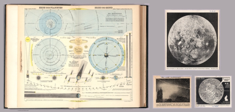
Full Title
Erde und Planeten. Erde und Mond. Gezeichn. H. Wagner. Gotha : Justus Perthes. Sydow-Wagners method. Schul-Atlas XXIII.
List No
13559.015
Note
13 Celestial charts on 1 sheet, showing the solar system, exhibiting the relative Position of earth and planets and earth and moon. Map accompanied by 3 photos: Das seltene Naturschauspiel, 1954. Das Ziel, 17.7.69. And Apollo-Landeplatz.
Author
[Sydow, Emil von., 1812-1873, Wagner, Hermann, 1840-1929]
Full Title
Gradnetz -Entwurfe. Unter Benutzung des ehemaligen. Entwurfs von H. Wagner. Gotha : Justus Perthes. Sydow-Wagners method. Schul-Atlas XXIII.
List No
13559.017
Note
Maps of the surface of the earth with graticule, representing meridians and parallel circles. Includes explanation of projections.
Author
[Sydow, Emil von., 1812-1873, Wagner, Hermann, 1840-1929]
Full Title
Gelandezeichnung. Gezeichn. v. V. Geyer. Gelande gest. v. A. Kramer. Entw. v. H. Wagner. Gotha : Justus Perthes. Sydow-Wagners method. Schul-Atlas XXIII.
List No
13559.019
Note
Maps and diagrams of landscape characterization in variable scales, showing topographic Terrain drawings.
Author
[Sydow, Emil von., 1812-1873, Wagner, Hermann, 1840-1929]
Full Title
Erdansichten. Gotha : Justus Perthes. Sydow-Wagners method. Schul-Atlas XXIII.
List No
13559.021
Note
Hemispheric maps of the world, with insets: Land hemisphere, Water hemisphere. Map of South Pole.
Author
[Sydow, Emil von., 1812-1873, Wagner, Hermann, 1840-1929]
Full Title
Tektonik und Geologie der Erde. Gotha : Justus Perthes. Sydow-Wagners method. Schul-Atlas XXIII.
List No
13559.023
Note
Tectonic map of the world, with 4 insets at the scale of 1:100,000,000. Including: North America; South America; Africa; Australia and Indonesia. Showing principal tectonic regions. Includes color coded tectonic classification for continental and oceanic.
Author
[Sydow, Emil von., 1812-1873, Wagner, Hermann, 1840-1929]
Full Title
Temperatur, Luftdruck, Winde. Gotha : Justus Perthes. Sydow-Wagners method. Schul-Atlas. XXIII.
List No
13559.025
Note
Six maps on 1 sheet, showing Temperature, air pressure and wind in January and July. Includes 4 insets of air circulation in Northern and Southern Hemispheres.
Author
[Sydow, Emil von., 1812-1873, Wagner, Hermann, 1840-1929]
Full Title
Niederschlage, Klimate. Gotha : Justus Perthes. Sydow-Wagners method. Schul-Atlas. XXIII.
List No
13559.027
Note
3 maps on 1 sheet. a: Durchschnittliche Jajrliche Niederschlagshöhe. b: Regenzeiten. c. Klimate. Showing average annual and seasonal rainfall and climate map of the world. "Eckerts flächentreue sinuslinien projektion". Includes explanation of the climate formulas from map 9c, on verso.
Author
[Sydow, Emil von., 1812-1873, Wagner, Hermann, 1840-1929]
Full Title
Meeresströmungen und Pflanzenverein Reiche, Tierwelt. Gotha : Justus Perthes. Sydow-Wagners method. Schul-Atlas. XXIII.
List No
13559.030
Note
3 maps of the world on 1 sheet. a: Naturliche Pflanzenvereinsreiche. b. Stromungen des Indischen Ozeans in Juli. c. Tiergeographiche Gliederung der Erdoberflache. Showing Ocean currents, and distribution of the wildlife and plant Kingdoms. Includes explanation of the map 10c, on verso.
Author
[Sydow, Emil von., 1812-1873, Wagner, Hermann, 1840-1929]
Full Title
Bevolkerungs- und Rassenverteilung, Polit, Herrschaft. Gotha : Justus Perthes. Sydow-Wagners method. Schul-Atlas. XXIII.
List No
13559.033
Note
3 maps of the world on 1 sheet, Showing the Distribution of the Human Race and the geographical population density in the world.
Author
[Sydow, Emil von., 1812-1873, Wagner, Hermann, 1840-1929]
Full Title
Die Wirtschaft der Erde. Gotha : Justus Perthes. Sydow-Wagners method. Schul-Atlas. XXIII.
List No
13559.036
Note
6 maps on 1 sheet, showing the world economy, agricultural zones, farming, and industry.
Author
[Sydow, Emil von., 1812-1873, Wagner, Hermann, 1840-1929]
Full Title
Europa : Ubersicht des relief. Gotha : Justus Perthes. Sydow-Wagners method. Schul-Atlas. XXII.
List No
13559.039
Note
Geologic map of Europe. Bonnesche projektion.
Author
[Sydow, Emil von., 1812-1873, Wagner, Hermann, 1840-1929]
Full Title
Europa : Geologie, Tektonic. Gotha : Justus Perthes. Sydow-Wagners method. Schul-Atlas. XXIII.
List No
13559.041
Note
Geologic map of Europe, Bonnesche projektion. With inset map: Tektonische Karte. Includes color coded reference to rock formations and land features.
Author
[Sydow, Emil von., 1812-1873, Wagner, Hermann, 1840-1929]
Full Title
Europa : Klima. Gotha : Justus Perthes. Sydow-Wagners method. Schul-Atlas. XXIII.
List No
13559.043
Note
4 climate map of Europe. Bonnesche projektion. Showing isotherm lines throughout Europe.
Author
[Sydow, Emil von., 1812-1873, Wagner, Hermann, 1840-1929]
Full Title
Europa : Boden, Vegetation, landwirtschaft, Verkehr. Gotha : Justus Perthes. Sydow-Wagners method. Schul-Atlas. XXIII.
List No
13559.045
Note
4 maps of Europe on 1 sheet. Showing Soil classification, natural vegetation, agricultural zoning, roads and transportation.
Author
[Sydow, Emil von., 1812-1873, Wagner, Hermann, 1840-1929]
Full Title
Europa : Verteilung der Bevolkerung 1935. Gotha : Justus Perthes. Sydow-Wagners method. Schul-Atlas. XXIII.
List No
13559.047
Note
Map of Europe. Showing distribution of the population, 1935. Albers equal-area conic projection.
Author
[Sydow, Emil von., 1812-1873, Wagner, Hermann, 1840-1929]
Full Title
Europa : Ubersicht der politischen Verhaltnisse und Hauptverkehrswege. Gotha : Justus Perthes. Sydow-Wagners method. Schul-Atlas. XXIII.
List No
13559.049
Note
Political map of Europe. Bonnesche projektion. Showing main roads, shipping routes and distances.
Author
[Sydow, Emil von., 1812-1873, Wagner, Hermann, 1840-1929]
Full Title
Mitteleuropa Relief. Gotha : Justus Perthes. Sydow-Wagners method. Schul-Atlas. XXIII.
List No
13559.051
Note
Relief map of Central Europe. Vereinfachte Kegelprojektion. Includes inset map of Hamburg. Relief shown by gradient tints, hachures and spot height. Depth shown by bathymetric tints, isolines and sounding.
Author
[Sydow, Emil von., 1812-1873, Wagner, Hermann, 1840-1929]
Full Title
(Covers to) Sydow-Wagners methodischer Schul-Atlas : 21 Auflage. Bearbeitet von H. Haack und H. Lautensach. 67 haupt - und 232 nebenkarten auf 64 tafeln mit einem namenverzeichnis. Berichtigter Neudruck 1940. Justus Perthes in Gotha.
List No
13557.001
Author
[Sydow, Emil von., 1812-1873, Wagner, Hermann, 1840-1929]
Full Title
(Title Page to) Sydow-Wagners methodischer Schul-Atlas : 21 Auflage. Bearbeitet von H. Haack und H. Lautensach. 67 haupt - und 232 nebenkarten auf 64 tafeln mit einem namenverzeichnis. Berichtigter Neudruck 1940. Justus Perthes in Gotha.
List No
13557.002
Author
[Sydow, Emil von., 1812-1873, Wagner, Hermann, 1840-1929]
Full Title
Orientierung : Der Nordliche Sternhimmel. Entworfen v. H. Wagner. Gotha : Justus Perthes. Sydow-Wagners method. Schul-Atlas. XXI.
List No
13557.012
Note
Map of the Northern Starry Sky, with 12 insets of astronomical charts.
Author
[Sydow, Emil von., 1812-1873, Wagner, Hermann, 1840-1929]
Full Title
Erde und Sonne. Entworfen v. H. Wagner. Gotha : Justus Perthes. Sydow-Wagners method. Schul-Atlas. XXI.
List No
13557.014
Note
10 celestial charts on 1 sheet, showing the position of the planet in relation to the sun.
Author
[Sydow, Emil von., 1812-1873, Wagner, Hermann, 1840-1929]
Full Title
Erde und Planeten. Erde und Mond. Entworfen v. H. Wagner. Gotha : Justus Perthes. Sydow-Wagners method. Schul-Atlas. XXI.
List No
13557.016
Note
13 Celestial charts on 1 sheet, showing the solar system, exhibiting the relative Position of earth and planets and earth and moon.
Author
[Sydow, Emil von., 1812-1873, Wagner, Hermann, 1840-1929]
Full Title
Gradnetz -Entwurfe. Unter benutzung des ehemaligen. Entworfen v. H. Wagner. Gotha : Justus Perthes. Sydow-Wagners method. Schul-Atlas. XXI.
List No
13557.018
Note
Maps of the surface of the earth with graticule, representing meridians and parallel circles. Includes explanation of projections.
Author
[Sydow, Emil von., 1812-1873, Wagner, Hermann, 1840-1929]
Full Title
Gelandezeichnung. Gezeichn. v. V. Geyer. Gelande gest. v. A. Kramer. Entw. v. H. Wagner. Gotha : Justus Perthes. Sydow-Wagners method. Schul-Atlas. XXI.
List No
13557.020
Note
Maps and diagrams of landscape characterization in variable scales, showing topographic Terrain drawings. Designed by H. Wagner. Drawn. by V. Geyer. Terrain by A. Kramer.
Author
[Sydow, Emil von., 1812-1873, Wagner, Hermann, 1840-1929]
Full Title
Erdansichten. Gotha : Justus Perthes. Sydow-Wagners method. Schul-Atlas. XXI.
List No
13557.022
Note
Hemispheric maps of the world. insets: Land hemisphere, Water hemisphere and Antarctica.
Author
[Sydow, Emil von., 1812-1873, Wagner, Hermann, 1840-1929]
Full Title
Tektonik und Geologie der Erde. Gotha : Justus Perthes. Sydow-Wagners method. Schul-Atlas. XXI.
List No
13557.024
Note
Tectonic map of the world, with 4 insets at the scale of 1:100,000,000: North America; South America; Africa; Australia and Indonesia. Showing principal tectonic regions. Includes color coded tectonic classification for continental and oceanic.
Author
[Sydow, Emil von., 1812-1873, Wagner, Hermann, 1840-1929]
Full Title
Temperatur, Luftdruck, Winde. Gotha : Justus Perthes. Sydow-Wagners method. Schul-Atlas. XXI.
List No
13557.026
Note
Six maps on 1 sheet, showing Temperature, air pressure and wind in January and July. Includes 4 insets of air circulation in Northern and Southern Hemispheres.
Author
[Sydow, Emil von., 1812-1873, Wagner, Hermann, 1840-1929]
Full Title
Niederschlage, Klimate. Gotha : Justus Perthes. Sydow-Wagners method. Schul-Atlas. XXI.
List No
13557.028
Note
3 maps on 1 sheet. a: Durchschnittliche Jajrliche Niederschlagshöhe. b: Regenzeiten. c. Klimate. Showing average annual and seasonal rainfall and climate map of the world. "Eckerts flächentreue sinuslinien projektion". Includes explanation of the climate formulas from map 8c, on verso.
Author
[Sydow, Emil von., 1812-1873, Wagner, Hermann, 1840-1929]
Full Title
Bevolkerungs- und Rassenverteilung, Polit, Herrschaft. Gotha : Justus Perthes. Sydow-Wagners method. Schul-Atlas. XXI.
List No
13557.034
Note
3 maps of the world on 1 sheet, Showing the Distribution of the Human Race and the geographical population density of the world.
Author
[Sydow, Emil von., 1812-1873, Wagner, Hermann, 1840-1929]
Full Title
Sprachen und Religionen. Gotha : Justus Perthes. Sydow-Wagners method. Schul-Atlas. XXI.
List No
13557.036
Note
Map of the world, with 4 insets. Showing the distribution of the languages,religions and races.
Author
[Sydow, Emil von., 1812-1873, Wagner, Hermann, 1840-1929]
Full Title
Das Deutschtum auf der Erde. Gotha : Justus Perthes. Sydow-Wagners method. Schul-Atlas : 21 Auflage. 1940.
List No
13557.038
Note
Map of the world, with 10 insets. Showing the spread of Germans on Earth.
Author
[Sydow, Emil von., 1812-1873, Wagner, Hermann, 1840-1929]
Full Title
Europa : übersicht des relief. Gotha : Justus Perthes. Sydow-Wagners method. Schul-Atlas. XXI.
List No
13557.044
Note
Geologic map of Europe. Relief shown by gradient tints, hachures and spot heights. Depth shown by bathymetric tints, isolines and soundings. Bonnesche projektion.
Author
[Sydow, Emil von., 1812-1873, Wagner, Hermann, 1840-1929]
Full Title
Europa : Geologie, Tektonic. Gotha : Justus Perthes. Sydow-Wagners method. Schul-Atlas. XXI.
List No
13557.046
Note
Geologic map of Europe, Bonnesche projektion. With inset map: Tektonische Karte. Includes color coded reference to rock formations and land features.
Author
[Sydow, Emil von., 1812-1873, Wagner, Hermann, 1840-1929]
Full Title
Europa : Klima. Gotha : Justus Perthes. Sydow-Wagners method. Schul-Atlas. XXI.
List No
13557.048
Note
4 climate map of Europe. Bonne projection. Showing isotherm lines throughout Europe.
Author
[Sydow, Emil von., 1812-1873, Wagner, Hermann, 1840-1929]
Full Title
Europa : Boden, Vegetation, landwirtschaft, Resenverhaltnisse. Gotha : Justus Perthes. Sydow-Wagners method. Schul-Atlas : 21 Auflage. 1940.
List No
13557.050
Note
4 maps of Europe on 1 sheet. Bonne projection. Showing Soil classification, natural vegetation, agricultural zoning, and reserves.
Author
[Sydow, Emil von., 1812-1873, Wagner, Hermann, 1840-1929]
Full Title
Europa : Verteilung der Bevolkerung 1935. Gotha : Justus Perthes. Sydow-Wagners method. Schul-Atlas. XXI.
List No
13557.052
Note
Map of Europe. Showing distribution of the population, 1935. Albers equal-area conic projection.
Author
[Sydow, Emil von., 1812-1873, Wagner, Hermann, 1840-1929]
Full Title
Europa : Ubersicht der politischen Verhaltnisse und Hauptverkehrswege. Gotha : Justus Perthes. Sydow-Wagners method. Schul-Atlas : 21 Auflage. 1940.
List No
13557.054
Note
Political map of Europe. Bonne projection. Showing main roads shipping routes and distances.
Author
[Sydow, Emil von., 1812-1873, Wagner, Hermann, 1840-1929]
Full Title
Europa und Mitteleuropa : Sprachen, Religionen, Bevölkerungsverteilung in Mitteleuropa. Gotha : Justus Perthes. Sydow-Wagners method. Schul-Atlas. XXI.
List No
13557.056
Note
5 maps of Europe and Central Europe on 1 sheet. Showing languages, religions, population distribution in Central Europe.
Author
[Sydow, Emil von., 1812-1873, Wagner, Hermann, 1840-1929]
Full Title
Mitteleuropa : Relief. Gotha : Justus Perthes. Sydow-Wagners method. Schul-Atlas. XXI.
List No
13557.058
Note
Relief map of Central Europe. Vereinfachte Kegelprojektion. Includes inset map of Hamburg. Shows political boundaries. Relief shown by gradient tints, hachures and spot height. Depth shown by bathymetric tints, isolines and sounding.
Author
[Sydow, Emil von., 1812-1873, Wagner, Hermann, 1840-1929]
Full Title
Mitteleuropa : Geologische Karte. Gotha : Justus Perthes. Sydow-Wagners method. Schul-Atlas : 21 Auflage. 1940.
List No
13557.060
Note
Geologic map of Central Europe. Vereinfachte Kegelprojektion. Includes color coded reference to rock formations and land features.
Author
[Sydow, Emil von., 1812-1873, Wagner, Hermann, 1840-1929]
Full Title
Landliche Siedlungsformen I (zu Tafel 23b). Gotha : Justus Perthes. Sydow-Wagners method. Schul-Atlas : 21 Auflage. 1940.
List No
13557.061
Note
11 plans on 1 sheet: Nos. 1-11. Supplement to: Mittleeuropa: Siedlung, Landwirschaft, Fruhlingseinzung: Zu Tafel 23b : Rural settlements, part I. Bound out of sequence.
Author
[Sydow, Emil von., 1812-1873, Wagner, Hermann, 1840-1929]
Full Title
Mitteleuropa : Klima, Morphologie. Gotha : Justus Perthes. Sydow-Wagners method. Schul-Atlas. XXI.
List No
13557.063
Note
4 maps of Central Europe on 1 sheet, Vereinfachte Kegelprojektion. Showing the temperature and precipitation, and structure of the land surface.
|