|
Author
[Ordnance Survey Office, Geikie, Archibald]
Full Title
(Composite of) Sheets 2 - 15. Ordnance Survey of England and Wales.
List No
8742.017
Author
Ordnance Survey Office
Full Title
74 Southport (Hills)
List No
6751.142
Note
The Ordnance Survey One-inch Revised New Series, England and Wales, was published between 1892-1908, in both outline sheets with contours and hill shaded sheets. This set of 691 maps is owned by the National Library of Scotland (NLS). Scans and georeferenced images were generously provided to us in 2014 as part of a joint project under the guidance of Christopher Fleet, Senior Map Curator at the NLS. A few sheets of the set are from the 3rd edition of the one inch maps, published in the early 1900's. For more detailed information on the Revised New Series, see the excellent summaries and map presentations on the NLS website, http://maps.nls.uk/os/one-inch-rev-new-series/index.html
Author
Ordnance Survey Office
Full Title
74 Southport (Outline)
List No
6751.143
Note
The Ordnance Survey One-inch Revised New Series, England and Wales, was published between 1892-1908, in both outline sheets with contours and hill shaded sheets. This set of 691 maps is owned by the National Library of Scotland (NLS). Scans and georeferenced images were generously provided to us in 2014 as part of a joint project under the guidance of Christopher Fleet, Senior Map Curator at the NLS. A few sheets of the set are from the 3rd edition of the one inch maps, published in the early 1900's. For more detailed information on the Revised New Series, see the excellent summaries and map presentations on the NLS website, http://maps.nls.uk/os/one-inch-rev-new-series/index.html
Author
Ordnance Survey Office
Full Title
75 Preston (Hills)
List No
6751.144
Note
The Ordnance Survey One-inch Revised New Series, England and Wales, was published between 1892-1908, in both outline sheets with contours and hill shaded sheets. This set of 691 maps is owned by the National Library of Scotland (NLS). Scans and georeferenced images were generously provided to us in 2014 as part of a joint project under the guidance of Christopher Fleet, Senior Map Curator at the NLS. A few sheets of the set are from the 3rd edition of the one inch maps, published in the early 1900's. For more detailed information on the Revised New Series, see the excellent summaries and map presentations on the NLS website, http://maps.nls.uk/os/one-inch-rev-new-series/index.html
Author
Ordnance Survey Office
Full Title
75 Preston (Outline)
List No
6751.145
Note
The Ordnance Survey One-inch Revised New Series, England and Wales, was published between 1892-1908, in both outline sheets with contours and hill shaded sheets. This set of 691 maps is owned by the National Library of Scotland (NLS). Scans and georeferenced images were generously provided to us in 2014 as part of a joint project under the guidance of Christopher Fleet, Senior Map Curator at the NLS. A few sheets of the set are from the 3rd edition of the one inch maps, published in the early 1900's. For more detailed information on the Revised New Series, see the excellent summaries and map presentations on the NLS website, http://maps.nls.uk/os/one-inch-rev-new-series/index.html
Author
Ordnance Survey Office
Full Title
76 Rochdale (Hills)
List No
6751.146
Note
The Ordnance Survey One-inch Revised New Series, England and Wales, was published between 1892-1908, in both outline sheets with contours and hill shaded sheets. This set of 691 maps is owned by the National Library of Scotland (NLS). Scans and georeferenced images were generously provided to us in 2014 as part of a joint project under the guidance of Christopher Fleet, Senior Map Curator at the NLS. A few sheets of the set are from the 3rd edition of the one inch maps, published in the early 1900's. For more detailed information on the Revised New Series, see the excellent summaries and map presentations on the NLS website, http://maps.nls.uk/os/one-inch-rev-new-series/index.html
Author
Ordnance Survey Office
Full Title
76 Rochdale (Outline)
List No
6751.147
Note
The Ordnance Survey One-inch Revised New Series, England and Wales, was published between 1892-1908, in both outline sheets with contours and hill shaded sheets. This set of 691 maps is owned by the National Library of Scotland (NLS). Scans and georeferenced images were generously provided to us in 2014 as part of a joint project under the guidance of Christopher Fleet, Senior Map Curator at the NLS. A few sheets of the set are from the 3rd edition of the one inch maps, published in the early 1900's. For more detailed information on the Revised New Series, see the excellent summaries and map presentations on the NLS website, http://maps.nls.uk/os/one-inch-rev-new-series/index.html
Author
Ordnance Survey Office
Full Title
77 Huddersfield (Hills)
List No
6751.148
Note
The Ordnance Survey One-inch Revised New Series, England and Wales, was published between 1892-1908, in both outline sheets with contours and hill shaded sheets. This set of 691 maps is owned by the National Library of Scotland (NLS). Scans and georeferenced images were generously provided to us in 2014 as part of a joint project under the guidance of Christopher Fleet, Senior Map Curator at the NLS. A few sheets of the set are from the 3rd edition of the one inch maps, published in the early 1900's. For more detailed information on the Revised New Series, see the excellent summaries and map presentations on the NLS website, http://maps.nls.uk/os/one-inch-rev-new-series/index.html
Author
Ordnance Survey Office
Full Title
77 Huddersfield (Outline)
List No
6751.149
Note
The Ordnance Survey One-inch Revised New Series, England and Wales, was published between 1892-1908, in both outline sheets with contours and hill shaded sheets. This set of 691 maps is owned by the National Library of Scotland (NLS). Scans and georeferenced images were generously provided to us in 2014 as part of a joint project under the guidance of Christopher Fleet, Senior Map Curator at the NLS. A few sheets of the set are from the 3rd edition of the one inch maps, published in the early 1900's. For more detailed information on the Revised New Series, see the excellent summaries and map presentations on the NLS website, http://maps.nls.uk/os/one-inch-rev-new-series/index.html
Author
Ordnance Survey Office
Full Title
78 Wakefield (Hills)
List No
6751.150
Note
The Ordnance Survey One-inch Revised New Series, England and Wales, was published between 1892-1908, in both outline sheets with contours and hill shaded sheets. This set of 691 maps is owned by the National Library of Scotland (NLS). Scans and georeferenced images were generously provided to us in 2014 as part of a joint project under the guidance of Christopher Fleet, Senior Map Curator at the NLS. A few sheets of the set are from the 3rd edition of the one inch maps, published in the early 1900's. For more detailed information on the Revised New Series, see the excellent summaries and map presentations on the NLS website, http://maps.nls.uk/os/one-inch-rev-new-series/index.html
Author
Ordnance Survey Office
Full Title
78 Wakefield (Outline)
List No
6751.151
Note
The Ordnance Survey One-inch Revised New Series, England and Wales, was published between 1892-1908, in both outline sheets with contours and hill shaded sheets. This set of 691 maps is owned by the National Library of Scotland (NLS). Scans and georeferenced images were generously provided to us in 2014 as part of a joint project under the guidance of Christopher Fleet, Senior Map Curator at the NLS. A few sheets of the set are from the 3rd edition of the one inch maps, published in the early 1900's. For more detailed information on the Revised New Series, see the excellent summaries and map presentations on the NLS website, http://maps.nls.uk/os/one-inch-rev-new-series/index.html
Author
Ordnance Survey Office
Full Title
83 Formby (Hills)
List No
6751.158
Note
The Ordnance Survey One-inch Revised New Series, England and Wales, was published between 1892-1908, in both outline sheets with contours and hill shaded sheets. This set of 691 maps is owned by the National Library of Scotland (NLS). Scans and georeferenced images were generously provided to us in 2014 as part of a joint project under the guidance of Christopher Fleet, Senior Map Curator at the NLS. A few sheets of the set are from the 3rd edition of the one inch maps, published in the early 1900's. For more detailed information on the Revised New Series, see the excellent summaries and map presentations on the NLS website, http://maps.nls.uk/os/one-inch-rev-new-series/index.html
Author
Ordnance Survey Office
Full Title
83 Formby (Outline)
List No
6751.159
Note
The Ordnance Survey One-inch Revised New Series, England and Wales, was published between 1892-1908, in both outline sheets with contours and hill shaded sheets. This set of 691 maps is owned by the National Library of Scotland (NLS). Scans and georeferenced images were generously provided to us in 2014 as part of a joint project under the guidance of Christopher Fleet, Senior Map Curator at the NLS. A few sheets of the set are from the 3rd edition of the one inch maps, published in the early 1900's. For more detailed information on the Revised New Series, see the excellent summaries and map presentations on the NLS website, http://maps.nls.uk/os/one-inch-rev-new-series/index.html
Author
Ordnance Survey Office
Full Title
84 Wigan (Hills)
List No
6751.160
Note
The Ordnance Survey One-inch Revised New Series, England and Wales, was published between 1892-1908, in both outline sheets with contours and hill shaded sheets. This set of 691 maps is owned by the National Library of Scotland (NLS). Scans and georeferenced images were generously provided to us in 2014 as part of a joint project under the guidance of Christopher Fleet, Senior Map Curator at the NLS. A few sheets of the set are from the 3rd edition of the one inch maps, published in the early 1900's. For more detailed information on the Revised New Series, see the excellent summaries and map presentations on the NLS website, http://maps.nls.uk/os/one-inch-rev-new-series/index.html
Author
Ordnance Survey Office
Full Title
84 Wigan (Outline)
List No
6751.161
Note
The Ordnance Survey One-inch Revised New Series, England and Wales, was published between 1892-1908, in both outline sheets with contours and hill shaded sheets. This set of 691 maps is owned by the National Library of Scotland (NLS). Scans and georeferenced images were generously provided to us in 2014 as part of a joint project under the guidance of Christopher Fleet, Senior Map Curator at the NLS. A few sheets of the set are from the 3rd edition of the one inch maps, published in the early 1900's. For more detailed information on the Revised New Series, see the excellent summaries and map presentations on the NLS website, http://maps.nls.uk/os/one-inch-rev-new-series/index.html
Author
Ordnance Survey Office
Full Title
85 Manchester (Hills)
List No
6751.162
Note
The Ordnance Survey One-inch Revised New Series, England and Wales, was published between 1892-1908, in both outline sheets with contours and hill shaded sheets. This set of 691 maps is owned by the National Library of Scotland (NLS). Scans and georeferenced images were generously provided to us in 2014 as part of a joint project under the guidance of Christopher Fleet, Senior Map Curator at the NLS. A few sheets of the set are from the 3rd edition of the one inch maps, published in the early 1900's. For more detailed information on the Revised New Series, see the excellent summaries and map presentations on the NLS website, http://maps.nls.uk/os/one-inch-rev-new-series/index.html
Author
Ordnance Survey Office
Full Title
85 Manchester (Outline)
List No
6751.163
Note
The Ordnance Survey One-inch Revised New Series, England and Wales, was published between 1892-1908, in both outline sheets with contours and hill shaded sheets. This set of 691 maps is owned by the National Library of Scotland (NLS). Scans and georeferenced images were generously provided to us in 2014 as part of a joint project under the guidance of Christopher Fleet, Senior Map Curator at the NLS. A few sheets of the set are from the 3rd edition of the one inch maps, published in the early 1900's. For more detailed information on the Revised New Series, see the excellent summaries and map presentations on the NLS website, http://maps.nls.uk/os/one-inch-rev-new-series/index.html
Author
Ordnance Survey Office
Full Title
86 Glossop (Hills)
List No
6751.164
Note
The Ordnance Survey One-inch Revised New Series, England and Wales, was published between 1892-1908, in both outline sheets with contours and hill shaded sheets. This set of 691 maps is owned by the National Library of Scotland (NLS). Scans and georeferenced images were generously provided to us in 2014 as part of a joint project under the guidance of Christopher Fleet, Senior Map Curator at the NLS. A few sheets of the set are from the 3rd edition of the one inch maps, published in the early 1900's. For more detailed information on the Revised New Series, see the excellent summaries and map presentations on the NLS website, http://maps.nls.uk/os/one-inch-rev-new-series/index.html
Author
Ordnance Survey Office
Full Title
86 Glossop (Outline)
List No
6751.165
Note
The Ordnance Survey One-inch Revised New Series, England and Wales, was published between 1892-1908, in both outline sheets with contours and hill shaded sheets. This set of 691 maps is owned by the National Library of Scotland (NLS). Scans and georeferenced images were generously provided to us in 2014 as part of a joint project under the guidance of Christopher Fleet, Senior Map Curator at the NLS. A few sheets of the set are from the 3rd edition of the one inch maps, published in the early 1900's. For more detailed information on the Revised New Series, see the excellent summaries and map presentations on the NLS website, http://maps.nls.uk/os/one-inch-rev-new-series/index.html
Author
Ordnance Survey Office
Full Title
87 Barnsley (Hills)
List No
6751.166
Note
The Ordnance Survey One-inch Revised New Series, England and Wales, was published between 1892-1908, in both outline sheets with contours and hill shaded sheets. This set of 691 maps is owned by the National Library of Scotland (NLS). Scans and georeferenced images were generously provided to us in 2014 as part of a joint project under the guidance of Christopher Fleet, Senior Map Curator at the NLS. A few sheets of the set are from the 3rd edition of the one inch maps, published in the early 1900's. For more detailed information on the Revised New Series, see the excellent summaries and map presentations on the NLS website, http://maps.nls.uk/os/one-inch-rev-new-series/index.html
Author
Ordnance Survey Office
Full Title
87 Barnsley (Outline)
List No
6751.167
Note
The Ordnance Survey One-inch Revised New Series, England and Wales, was published between 1892-1908, in both outline sheets with contours and hill shaded sheets. This set of 691 maps is owned by the National Library of Scotland (NLS). Scans and georeferenced images were generously provided to us in 2014 as part of a joint project under the guidance of Christopher Fleet, Senior Map Curator at the NLS. A few sheets of the set are from the 3rd edition of the one inch maps, published in the early 1900's. For more detailed information on the Revised New Series, see the excellent summaries and map presentations on the NLS website, http://maps.nls.uk/os/one-inch-rev-new-series/index.html
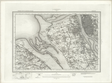
Author
Ordnance Survey Office
Full Title
96 Liverpool (Hills)
List No
6751.183
Note
The Ordnance Survey One-inch Revised New Series, England and Wales, was published between 1892-1908, in both outline sheets with contours and hill shaded sheets. This set of 691 maps is owned by the National Library of Scotland (NLS). Scans and georeferenced images were generously provided to us in 2014 as part of a joint project under the guidance of Christopher Fleet, Senior Map Curator at the NLS. A few sheets of the set are from the 3rd edition of the one inch maps, published in the early 1900's. For more detailed information on the Revised New Series, see the excellent summaries and map presentations on the NLS website, http://maps.nls.uk/os/one-inch-rev-new-series/index.html
Author
Ordnance Survey Office
Full Title
96 Liverpool (Outline)
List No
6751.184
Note
The Ordnance Survey One-inch Revised New Series, England and Wales, was published between 1892-1908, in both outline sheets with contours and hill shaded sheets. This set of 691 maps is owned by the National Library of Scotland (NLS). Scans and georeferenced images were generously provided to us in 2014 as part of a joint project under the guidance of Christopher Fleet, Senior Map Curator at the NLS. A few sheets of the set are from the 3rd edition of the one inch maps, published in the early 1900's. For more detailed information on the Revised New Series, see the excellent summaries and map presentations on the NLS website, http://maps.nls.uk/os/one-inch-rev-new-series/index.html
Author
Ordnance Survey Office
Full Title
97 Runcorn (Hills)
List No
6751.185
Note
The Ordnance Survey One-inch Revised New Series, England and Wales, was published between 1892-1908, in both outline sheets with contours and hill shaded sheets. This set of 691 maps is owned by the National Library of Scotland (NLS). Scans and georeferenced images were generously provided to us in 2014 as part of a joint project under the guidance of Christopher Fleet, Senior Map Curator at the NLS. A few sheets of the set are from the 3rd edition of the one inch maps, published in the early 1900's. For more detailed information on the Revised New Series, see the excellent summaries and map presentations on the NLS website, http://maps.nls.uk/os/one-inch-rev-new-series/index.html
Author
Ordnance Survey Office
Full Title
97 Runcorn (Outline)
List No
6751.186
Note
The Ordnance Survey One-inch Revised New Series, England and Wales, was published between 1892-1908, in both outline sheets with contours and hill shaded sheets. This set of 691 maps is owned by the National Library of Scotland (NLS). Scans and georeferenced images were generously provided to us in 2014 as part of a joint project under the guidance of Christopher Fleet, Senior Map Curator at the NLS. A few sheets of the set are from the 3rd edition of the one inch maps, published in the early 1900's. For more detailed information on the Revised New Series, see the excellent summaries and map presentations on the NLS website, http://maps.nls.uk/os/one-inch-rev-new-series/index.html
Author
Ordnance Survey Office
Full Title
98 Stockport (Hills)
List No
6751.187
Note
The Ordnance Survey One-inch Revised New Series, England and Wales, was published between 1892-1908, in both outline sheets with contours and hill shaded sheets. This set of 691 maps is owned by the National Library of Scotland (NLS). Scans and georeferenced images were generously provided to us in 2014 as part of a joint project under the guidance of Christopher Fleet, Senior Map Curator at the NLS. A few sheets of the set are from the 3rd edition of the one inch maps, published in the early 1900's. For more detailed information on the Revised New Series, see the excellent summaries and map presentations on the NLS website, http://maps.nls.uk/os/one-inch-rev-new-series/index.html
Author
Ordnance Survey Office
Full Title
98 Stockport (Outline)
List No
6751.188
Note
The Ordnance Survey One-inch Revised New Series, England and Wales, was published between 1892-1908, in both outline sheets with contours and hill shaded sheets. This set of 691 maps is owned by the National Library of Scotland (NLS). Scans and georeferenced images were generously provided to us in 2014 as part of a joint project under the guidance of Christopher Fleet, Senior Map Curator at the NLS. A few sheets of the set are from the 3rd edition of the one inch maps, published in the early 1900's. For more detailed information on the Revised New Series, see the excellent summaries and map presentations on the NLS website, http://maps.nls.uk/os/one-inch-rev-new-series/index.html
Author
Ordnance Survey Office
Full Title
99 Chapel en le Frith (Hills)
List No
6751.189
Note
The Ordnance Survey One-inch Revised New Series, England and Wales, was published between 1892-1908, in both outline sheets with contours and hill shaded sheets. This set of 691 maps is owned by the National Library of Scotland (NLS). Scans and georeferenced images were generously provided to us in 2014 as part of a joint project under the guidance of Christopher Fleet, Senior Map Curator at the NLS. A few sheets of the set are from the 3rd edition of the one inch maps, published in the early 1900's. For more detailed information on the Revised New Series, see the excellent summaries and map presentations on the NLS website, http://maps.nls.uk/os/one-inch-rev-new-series/index.html
Author
Ordnance Survey Office
Full Title
99 Chapel en le Frith (Outline)
List No
6751.190
Note
The Ordnance Survey One-inch Revised New Series, England and Wales, was published between 1892-1908, in both outline sheets with contours and hill shaded sheets. This set of 691 maps is owned by the National Library of Scotland (NLS). Scans and georeferenced images were generously provided to us in 2014 as part of a joint project under the guidance of Christopher Fleet, Senior Map Curator at the NLS. A few sheets of the set are from the 3rd edition of the one inch maps, published in the early 1900's. For more detailed information on the Revised New Series, see the excellent summaries and map presentations on the NLS website, http://maps.nls.uk/os/one-inch-rev-new-series/index.html
Author
Ordnance Survey Office
Full Title
100 Sheffield (Outline)
List No
6751.192
Note
The Ordnance Survey One-inch Revised New Series, England and Wales, was published between 1892-1908, in both outline sheets with contours and hill shaded sheets. This set of 691 maps is owned by the National Library of Scotland (NLS). Scans and georeferenced images were generously provided to us in 2014 as part of a joint project under the guidance of Christopher Fleet, Senior Map Curator at the NLS. A few sheets of the set are from the 3rd edition of the one inch maps, published in the early 1900's. For more detailed information on the Revised New Series, see the excellent summaries and map presentations on the NLS website, http://maps.nls.uk/os/one-inch-rev-new-series/index.html
Author
Ordnance Survey Office
Full Title
140 Burton upon Trent (Hills)
List No
6751.269
Note
The Ordnance Survey One-inch Revised New Series, England and Wales, was published between 1892-1908, in both outline sheets with contours and hill shaded sheets. This set of 691 maps is owned by the National Library of Scotland (NLS). Scans and georeferenced images were generously provided to us in 2014 as part of a joint project under the guidance of Christopher Fleet, Senior Map Curator at the NLS. A few sheets of the set are from the 3rd edition of the one inch maps, published in the early 1900's. For more detailed information on the Revised New Series, see the excellent summaries and map presentations on the NLS website, http://maps.nls.uk/os/one-inch-rev-new-series/index.html
Author
Ordnance Survey Office
Full Title
140 Burton upon Trent (Outline)
List No
6751.270
Note
The Ordnance Survey One-inch Revised New Series, England and Wales, was published between 1892-1908, in both outline sheets with contours and hill shaded sheets. This set of 691 maps is owned by the National Library of Scotland (NLS). Scans and georeferenced images were generously provided to us in 2014 as part of a joint project under the guidance of Christopher Fleet, Senior Map Curator at the NLS. A few sheets of the set are from the 3rd edition of the one inch maps, published in the early 1900's. For more detailed information on the Revised New Series, see the excellent summaries and map presentations on the NLS website, http://maps.nls.uk/os/one-inch-rev-new-series/index.html
Author
Ordnance Survey Office
Full Title
141 Loughborough (Hills)
List No
6751.271
Note
The Ordnance Survey One-inch Revised New Series, England and Wales, was published between 1892-1908, in both outline sheets with contours and hill shaded sheets. This set of 691 maps is owned by the National Library of Scotland (NLS). Scans and georeferenced images were generously provided to us in 2014 as part of a joint project under the guidance of Christopher Fleet, Senior Map Curator at the NLS. A few sheets of the set are from the 3rd edition of the one inch maps, published in the early 1900's. For more detailed information on the Revised New Series, see the excellent summaries and map presentations on the NLS website, http://maps.nls.uk/os/one-inch-rev-new-series/index.html
Author
Ordnance Survey Office
Full Title
141 Loughborough (Outline)
List No
6751.272
Note
The Ordnance Survey One-inch Revised New Series, England and Wales, was published between 1892-1908, in both outline sheets with contours and hill shaded sheets. This set of 691 maps is owned by the National Library of Scotland (NLS). Scans and georeferenced images were generously provided to us in 2014 as part of a joint project under the guidance of Christopher Fleet, Senior Map Curator at the NLS. A few sheets of the set are from the 3rd edition of the one inch maps, published in the early 1900's. For more detailed information on the Revised New Series, see the excellent summaries and map presentations on the NLS website, http://maps.nls.uk/os/one-inch-rev-new-series/index.html
Author
Ordnance Survey Office
Full Title
201 Banbury (Hills)
List No
6751.388
Note
The Ordnance Survey One-inch Revised New Series, England and Wales, was published between 1892-1908, in both outline sheets with contours and hill shaded sheets. This set of 691 maps is owned by the National Library of Scotland (NLS). Scans and georeferenced images were generously provided to us in 2014 as part of a joint project under the guidance of Christopher Fleet, Senior Map Curator at the NLS. A few sheets of the set are from the 3rd edition of the one inch maps, published in the early 1900's. For more detailed information on the Revised New Series, see the excellent summaries and map presentations on the NLS website, http://maps.nls.uk/os/one-inch-rev-new-series/index.html
Author
Ordnance Survey Office
Full Title
201 Banbury (Outline)
List No
6751.389
Note
The Ordnance Survey One-inch Revised New Series, England and Wales, was published between 1892-1908, in both outline sheets with contours and hill shaded sheets. This set of 691 maps is owned by the National Library of Scotland (NLS). Scans and georeferenced images were generously provided to us in 2014 as part of a joint project under the guidance of Christopher Fleet, Senior Map Curator at the NLS. A few sheets of the set are from the 3rd edition of the one inch maps, published in the early 1900's. For more detailed information on the Revised New Series, see the excellent summaries and map presentations on the NLS website, http://maps.nls.uk/os/one-inch-rev-new-series/index.html
Author
Ordnance Survey Office
Full Title
202 Towcester (Outline)
List No
6751.391
Note
The Ordnance Survey One-inch Revised New Series, England and Wales, was published between 1892-1908, in both outline sheets with contours and hill shaded sheets. This set of 691 maps is owned by the National Library of Scotland (NLS). Scans and georeferenced images were generously provided to us in 2014 as part of a joint project under the guidance of Christopher Fleet, Senior Map Curator at the NLS. A few sheets of the set are from the 3rd edition of the one inch maps, published in the early 1900's. For more detailed information on the Revised New Series, see the excellent summaries and map presentations on the NLS website, http://maps.nls.uk/os/one-inch-rev-new-series/index.html
Author
Ordnance Survey Office
Full Title
203 Bedford (Outline)
List No
6751.393
Note
The Ordnance Survey One-inch Revised New Series, England and Wales, was published between 1892-1908, in both outline sheets with contours and hill shaded sheets. This set of 691 maps is owned by the National Library of Scotland (NLS). Scans and georeferenced images were generously provided to us in 2014 as part of a joint project under the guidance of Christopher Fleet, Senior Map Curator at the NLS. A few sheets of the set are from the 3rd edition of the one inch maps, published in the early 1900's. For more detailed information on the Revised New Series, see the excellent summaries and map presentations on the NLS website, http://maps.nls.uk/os/one-inch-rev-new-series/index.html
Author
Ordnance Survey Office
Full Title
204 Biggleswade (Hills)
List No
6751.394
Note
The Ordnance Survey One-inch Revised New Series, England and Wales, was published between 1892-1908, in both outline sheets with contours and hill shaded sheets. This set of 691 maps is owned by the National Library of Scotland (NLS). Scans and georeferenced images were generously provided to us in 2014 as part of a joint project under the guidance of Christopher Fleet, Senior Map Curator at the NLS. A few sheets of the set are from the 3rd edition of the one inch maps, published in the early 1900's. For more detailed information on the Revised New Series, see the excellent summaries and map presentations on the NLS website, http://maps.nls.uk/os/one-inch-rev-new-series/index.html
Author
Ordnance Survey Office
Full Title
204 Biggleswade (Outline)
List No
6751.395
Note
The Ordnance Survey One-inch Revised New Series, England and Wales, was published between 1892-1908, in both outline sheets with contours and hill shaded sheets. This set of 691 maps is owned by the National Library of Scotland (NLS). Scans and georeferenced images were generously provided to us in 2014 as part of a joint project under the guidance of Christopher Fleet, Senior Map Curator at the NLS. A few sheets of the set are from the 3rd edition of the one inch maps, published in the early 1900's. For more detailed information on the Revised New Series, see the excellent summaries and map presentations on the NLS website, http://maps.nls.uk/os/one-inch-rev-new-series/index.html
Author
Ordnance Survey Office
Full Title
207 Ipswich (Hills)
List No
6751.400
Note
The Ordnance Survey One-inch Revised New Series, England and Wales, was published between 1892-1908, in both outline sheets with contours and hill shaded sheets. This set of 691 maps is owned by the National Library of Scotland (NLS). Scans and georeferenced images were generously provided to us in 2014 as part of a joint project under the guidance of Christopher Fleet, Senior Map Curator at the NLS. A few sheets of the set are from the 3rd edition of the one inch maps, published in the early 1900's. For more detailed information on the Revised New Series, see the excellent summaries and map presentations on the NLS website, http://maps.nls.uk/os/one-inch-rev-new-series/index.html
Author
Ordnance Survey Office
Full Title
207 Ipswich (Outline)
List No
6751.401
Note
The Ordnance Survey One-inch Revised New Series, England and Wales, was published between 1892-1908, in both outline sheets with contours and hill shaded sheets. This set of 691 maps is owned by the National Library of Scotland (NLS). Scans and georeferenced images were generously provided to us in 2014 as part of a joint project under the guidance of Christopher Fleet, Senior Map Curator at the NLS. A few sheets of the set are from the 3rd edition of the one inch maps, published in the early 1900's. For more detailed information on the Revised New Series, see the excellent summaries and map presentations on the NLS website, http://maps.nls.uk/os/one-inch-rev-new-series/index.html
Author
Ordnance Survey Office
Full Title
214 Talgarth (Hills)
List No
6751.414
Note
The Ordnance Survey One-inch Revised New Series, England and Wales, was published between 1892-1908, in both outline sheets with contours and hill shaded sheets. This set of 691 maps is owned by the National Library of Scotland (NLS). Scans and georeferenced images were generously provided to us in 2014 as part of a joint project under the guidance of Christopher Fleet, Senior Map Curator at the NLS. A few sheets of the set are from the 3rd edition of the one inch maps, published in the early 1900's. For more detailed information on the Revised New Series, see the excellent summaries and map presentations on the NLS website, http://maps.nls.uk/os/one-inch-rev-new-series/index.html
Author
Ordnance Survey Office
Full Title
214 Talgarth (Outline)
List No
6751.415
Note
The Ordnance Survey One-inch Revised New Series, England and Wales, was published between 1892-1908, in both outline sheets with contours and hill shaded sheets. This set of 691 maps is owned by the National Library of Scotland (NLS). Scans and georeferenced images were generously provided to us in 2014 as part of a joint project under the guidance of Christopher Fleet, Senior Map Curator at the NLS. A few sheets of the set are from the 3rd edition of the one inch maps, published in the early 1900's. For more detailed information on the Revised New Series, see the excellent summaries and map presentations on the NLS website, http://maps.nls.uk/os/one-inch-rev-new-series/index.html
Author
Ordnance Survey Office
Full Title
217 Moreton in the Marsh (Hills)
List No
6751.420
Note
The Ordnance Survey One-inch Revised New Series, England and Wales, was published between 1892-1908, in both outline sheets with contours and hill shaded sheets. This set of 691 maps is owned by the National Library of Scotland (NLS). Scans and georeferenced images were generously provided to us in 2014 as part of a joint project under the guidance of Christopher Fleet, Senior Map Curator at the NLS. A few sheets of the set are from the 3rd edition of the one inch maps, published in the early 1900's. For more detailed information on the Revised New Series, see the excellent summaries and map presentations on the NLS website, http://maps.nls.uk/os/one-inch-rev-new-series/index.html
Author
Ordnance Survey Office
Full Title
217 Moreton in the Marsh (Outline)
List No
6751.421
Note
The Ordnance Survey One-inch Revised New Series, England and Wales, was published between 1892-1908, in both outline sheets with contours and hill shaded sheets. This set of 691 maps is owned by the National Library of Scotland (NLS). Scans and georeferenced images were generously provided to us in 2014 as part of a joint project under the guidance of Christopher Fleet, Senior Map Curator at the NLS. A few sheets of the set are from the 3rd edition of the one inch maps, published in the early 1900's. For more detailed information on the Revised New Series, see the excellent summaries and map presentations on the NLS website, http://maps.nls.uk/os/one-inch-rev-new-series/index.html
Author
Ordnance Survey Office
Full Title
218 Chipping Norton (Hills)
List No
6751.422
Note
The Ordnance Survey One-inch Revised New Series, England and Wales, was published between 1892-1908, in both outline sheets with contours and hill shaded sheets. This set of 691 maps is owned by the National Library of Scotland (NLS). Scans and georeferenced images were generously provided to us in 2014 as part of a joint project under the guidance of Christopher Fleet, Senior Map Curator at the NLS. A few sheets of the set are from the 3rd edition of the one inch maps, published in the early 1900's. For more detailed information on the Revised New Series, see the excellent summaries and map presentations on the NLS website, http://maps.nls.uk/os/one-inch-rev-new-series/index.html
Author
Ordnance Survey Office
Full Title
218 Chipping Norton (Outline)
List No
6751.423
Note
The Ordnance Survey One-inch Revised New Series, England and Wales, was published between 1892-1908, in both outline sheets with contours and hill shaded sheets. This set of 691 maps is owned by the National Library of Scotland (NLS). Scans and georeferenced images were generously provided to us in 2014 as part of a joint project under the guidance of Christopher Fleet, Senior Map Curator at the NLS. A few sheets of the set are from the 3rd edition of the one inch maps, published in the early 1900's. For more detailed information on the Revised New Series, see the excellent summaries and map presentations on the NLS website, http://maps.nls.uk/os/one-inch-rev-new-series/index.html
Author
Ordnance Survey Office
Full Title
219 Buckingham (Outline)
List No
6751.425
Note
The Ordnance Survey One-inch Revised New Series, England and Wales, was published between 1892-1908, in both outline sheets with contours and hill shaded sheets. This set of 691 maps is owned by the National Library of Scotland (NLS). Scans and georeferenced images were generously provided to us in 2014 as part of a joint project under the guidance of Christopher Fleet, Senior Map Curator at the NLS. A few sheets of the set are from the 3rd edition of the one inch maps, published in the early 1900's. For more detailed information on the Revised New Series, see the excellent summaries and map presentations on the NLS website, http://maps.nls.uk/os/one-inch-rev-new-series/index.html
Author
Ordnance Survey Office
Full Title
220 Leighton Buzzard (Outline)
List No
6751.427
Note
The Ordnance Survey One-inch Revised New Series, England and Wales, was published between 1892-1908, in both outline sheets with contours and hill shaded sheets. This set of 691 maps is owned by the National Library of Scotland (NLS). Scans and georeferenced images were generously provided to us in 2014 as part of a joint project under the guidance of Christopher Fleet, Senior Map Curator at the NLS. A few sheets of the set are from the 3rd edition of the one inch maps, published in the early 1900's. For more detailed information on the Revised New Series, see the excellent summaries and map presentations on the NLS website, http://maps.nls.uk/os/one-inch-rev-new-series/index.html
|