|
REFINE
Browse All : Images of Turkey and Istanbul (Turkey)
1-30 of 30
Author
[Lapie, Pierre M., 1779-1850, Orgiazzi, J.A.]
Full Title
Carte de l'Empire Ottoman en Europe, en Asie et en Afrique, Avec Les Pays Limitrophes... 1828
List No
15511.000
Note
Inset map of Instanbul at scale 1:46,000
Author
Esref, Mehmed, 1847-1912
Full Title
Qustuntunia = Istanbul. (to accompany) Tarih-i umumi ve ʻOsmanii : aṭlasi = Historical atlas of the world and Ottoman. Mehmed Esref. 1329 (1913).
List No
13431.028
Note
Color Plan of Istanbul. Shows districts, major towns, landmarks and buildings. Includes legend, 2 inset plans of the city wall, Constantinople center and view of fortress.
Author
Esref, Mehmed, 1847-1912
Full Title
(Dulat Osmani = Ottoman Empire). (to accompany) Tarih-i umumi ve ʻOsmanii : aṭlasi = Historical atlas of the world and Ottoman. Mehmed Esref. 1329 (1913).
List No
13431.029
Note
Color map of Ottoman Empire on double page sheet. with 2 insets: Plan of Topkapı Palace and map of Constantinople.
Author
Scheda, Josef, Ritter von, 1815-1888
Full Title
General-Karte der Europaeischen Turkei und des Konigreiches Griechenland. Herausgegeben von Josef Ritter v. Scheda. K.K. Oesterr Oberst. (with) Plan von Constantinopel.
List No
11517.024
Note
1 color map of Ottoman Empire in Europe and Kingdom of Greece on 13 sheets, dissected and mounted on linen; 193 x 151, sheets 53 x 53 or smaller, folded into half leather black slipcase with title "General-Karte der Europ Turkei und des Konigr Griechenland" in gilt. Relief shown by shading. Includes index map on additional sheet and inset "Plan von Constantinopel" on sheet XI. Map shows political and administrative divisions, cities, towns, roads, rivers, lakes and landmarks. Includes legend, abbreviation table and statistical table.
Author
Kiepert, Heinrich
Full Title
General-Karte von der Europäischen Türkei. Nach allen vorhandenen Originalkarten und Itinerarischen hülfsmitteln bearbeitet und gezeichnet von Heinrich Kiepert. Schrift gestochen von W. u. C. Kratz in Weimar. Berlin, in commission bei Dietrich Reimer. 1870. Terrain radirt von W. Kratz, Schleich u. Sporer.
List No
14023.002
Note
Case map of European Turkey. Lithograph on paper with colored outlines, sectioned and mounted on linen, which is folded and inserted within a case made of tan board. Shows political boundaries, railroads and water routes. Includes four bar scales and a scale statement. Handwritten annotations in blue crayon tracing routes. Map 82 x 127 cm, on sheet 90 x 129 cm,folded to 23 x 32 cm, inside case 23 x 33 cm. With 3 insets: Das Fürstenthum Zrnagora oder Montenegro (27 x 25 cm, with scale 1:500,000) -- Der befestigte südliche Theil der Dardenellen Strasse (shows bathymetry; 16 x 14 cm, with scale 1:200,000) -- Constantinopel und der Bosporus (indexed; shows bathymetry; 16 x 12 cm, with scale 1:200,000).
Author
[Chatelain Henri, 1684-1743, Gueudeville, Nicolas]
Full Title
Bosphore de Thrace. Tom. V, No.9. Pag. 22. (to accompany) Atlas Historique ... Tom. V. A Amsterdam, chez L'Honore & Chatelain Libraires. M DCC XIX (1719).
List No
13272.461
Note
3 engraved views: Vue De Constantinople Due Cote Du Bosphore; Aqueduc De Constantinople; Colomne De Pompee. Includes descriptive text.
Author
Khanzadyan, Zadig
Full Title
Valeur totale des importations de Constantinople par pays de province. Dressee par Z. Khanzadian. (to accompany) Atlas de geographie economique de Turquie : par Z. Khanzadian. Editeur L. de Bertalot. 1924.
List No
13321.046
Note
Color diagrams showing total value of imports from Constantinople.
Author
Hellert, J. J.
Full Title
Plan de Constantinople et de ses faubourgs, a'aprees Kauffer, Le Chevalier, Barbiedu Bocage, et J. Hammer. Par J. Hellert. Paris 1843. Grave par par U. Muschani. Imprime chez Thierry Freres, Paris. Atlas de l'Empire Ottoman, par J.J. Hellert. Planche XXXVII. (to accompany) Nouvel atlas physique, politique, et historique de l'Empire Ottoman... 1844.
List No
13229.046
Note
Engraved folded Plan of Istanbul and its environs. Showing the changes which have been made since the years 1776 and 1786 until the year 1831. Includes index to suburbs and quarters (Mahalles).
Author
[Nasrullah, Mehmet, Rushtu, Mehmet, Eshref, Mehmet]
Full Title
Istanbul Vilayeti. (to accompany) Memalik-i Mahruse-yi Shahaneʼye mahsus : Mukemmel ve mufassal atlas = Special Imperial complete and detailed atlas of the protected countries. Asar: Mehmet Nasrullah, Mehmet Rushtu, Mehmet Eshref. Kitaphane-yi Tefeyyuz. Istanbul: Shirket-i Murettibiye Matbaasi - 1325 (1909).
List No
13019.006
Note
Detailed color map of Istanbul (Constantinople) province. Showing administrative boundaries, major cities, towns, roads, rivers and mountains. Relief shown by hachure.
Author
Society for the Diffusion of Useful Knowledge (Great Britain)
Full Title
Constantinople. Stambool. Engraved by B.R. Davies. Published by the Society for the Diffusion of Useful Knowledge, 59 Lincolns Inn Fields, Septr. 1840. (London: Chapman & Hall, 1844)
List No
0890.169
Note
Engraved map. Hand col. Source: Hellert.
Author
Pirî Reis, d. 1554?
Full Title
fol. 370b City of Constantinople
List No
10108.750
Note
Author's name given on fol. 376b as Raʾīs al-Baḥr Pīrī ibn Muḥammad; author dates preferred by (Walters) cataloger: d. 962 AH / 1555 CE
Author
Pirî Reis, d. 1554?
Full Title
fol. 371a Coastline of the Black Sea from Istanbul to Geresun
List No
10108.753
Note
Author's name given on fol. 376b as Raʾīs al-Baḥr Pīrī ibn Muḥammad; author dates preferred by (Walters) cataloger: d. 962 AH / 1555 CE
Author
Fer, Nicolas de, 1646-1720
Full Title
Veue de Constantinople. (to accompany) Les forces de l'Europe ... Le tout recueilli par les soins du Sr. de Fer ... Huitieme partie. A Paris, chez l'auteur dans l'Isle du palais. M. DC. XCVI (1696).
List No
11668.202
Note
Engraved panoramic view of Istanbul. Shows fortress, ports, landmarks and buildings. Relief shown pictorially.
Author
Orgiazzi, J.A.
Full Title
Carte de l'Empire Ottoman (western sheet). (inset) Constanople.
List No
12050.045
Note
Date estimated; based on newest map sheet in atlas, 1854.
Author
[Orgiazzi, J.A., Picquet]
Full Title
(Composite Map) Carte de l'Empire Ottoman.
List No
12050.047
Note
Date estimated; based on newest map sheet in atlas, 1854.
Author
[Briet, Philip, 1601-1668, Cramoisy, Sebastiani, Cramoisy, Gabrielis]
Full Title
La Romanie ou la Thrace. (inset) Stamboul ou Constantinople.
List No
12063.120
Author
[Smith, William, 1813-1893, Muller, Charles]
Full Title
Nineveh. Troy : reduced from Dr. Schliemann's plan. Carthage. Alexandria. Constantinople. Stanford's Geographical Estabt. London. John Murray. (to accompany) Dr. William Smith's Ancient atlas. 43. 1874.
List No
13007.099
Note
5 maps on 1 sheet, hand color. Shows place names, fortress, landmarks, roads, trails, rivers, canals and mountains. Relief shown by hachures.
Author
Luffman, John, 1756-1846
Full Title
The port and canal of Constantinople. Engraved for Luffman's Select plans of the principal cities, ports, harbours, forts, &c. in the world. London. Engraved and published Jany. 1, 1800, by John Luffman.
List No
13189.029
Note
Hand colored map. Prime meridian is London. Includes historical text at the foot of map.
Author
Luffman, John, 1756-1846
Full Title
Constantinople. Engraved for Luffman's Select plans of the principal cities, ports, harbours, forts, &c. in the world. London. Engraved and published April 1, 1800. by Luffman.
List No
13189.041
Note
Hand colored plan. Prime meridian is London. Includes historical text at the foot of map, and key to the important sites.
Author
[Chatelain Henri, 1684-1743, Gueudeville, Nicolas]
Full Title
Etat abrege de la maison du grand seigneur, de ses revenus et le gouvernement civil, militaire et ecclesiastiques de cet empire. Tome 4. No. 39. (to accompany) Atlas Historique ... Tome IV. A Amsterdam, chez les Freres Chatelain Libraires. M DCC XIV (1714).
List No
13272.424
Note
Engraved views of Vue du serrail de Constantinople. Vue de Constantinople. Vue de Sainte Sophie. includes descriptive text about the administration of the government of the Sultan and of the religious orders in Turkey.
Author
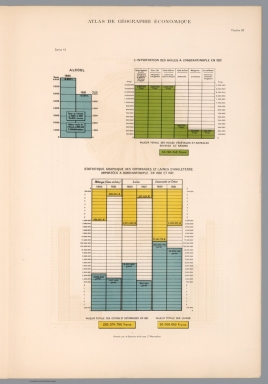
Khanzadyan, Zadig
Full Title
Alcool. l' importations huiles a Constantinople en 1921. Statistique graphiquedes cottonnades et laines d' Angleterre. Imports a Constantinople en 1920-1921. Dressee par Z. Khanzadian. (to accompany) Atlas de geographie economique de Turquie : par Z. Khanzadian. Editeur L. de Bertalot. 1924.
List No
13321.047
Note
Color diagrams showing imports from and to Constantinople, in 1920-1921.
Author
[Sydow, Emil von., 1812-1873, Wagner, Hermann, 1840-1929]
Full Title
Konstantinopel. Athen. Gotha : Justus Perthes. Sydow-Wagners method. Schul-Atlas. XXIII.
List No
13559.102
Note
2 city plans on 1 sheet.
Author
[Stieler, Adolf, Petermann, A.]
Full Title
Die Europaische Turkei Im Maassstabe Von 1:2.500.000. Von A. Petermann. Bearbeitet v. H. Habenicht. Gotha: Justus Perthes 1874.
List No
2449.061
Note
In outline color with two inset maps: The Bosporus and Istanbul.
Author
Spruner von Merz, Karl
Full Title
Das Byzantinische Reich bis in das XIte. Jahrhundert. (with) Constantinopolis. Gestochen v. C. Poppey. K.v. Spruner's histor. Atlas: S.-O.-Europa u. V.-Asien No. I. Gotha: Justhus Perthes. Revid. 1855.
List No
2600.048
Note
Hand colored map. Relief shown by hachures.
Author
Fullarton, A. & Co.
Full Title
Turkey; Central Mediterranean Regions. (with) 1. The Grecian Archipelago according to the English Admiralty Survey (1828-1849) drawn by Augustus Petermann F.R.G.S. Engraved by G.H. Swanston. 2. Constantinople. According to the Survey of Dufour and Admiralty Charts. By G.H. Swanston, Edinr. LII. A. Fullarton & Co. London, Edinburgh & Dublin.
List No
3007.053
Note
Maps in outline color with drawing surrounding the maps in full color. Drawings are of the animals, plants, people, and famous sites of the region.
Author
Grassl, J. (Joseph)
Full Title
(Neueste Special & Kriegs-Karte der) europaischen Turkey in IV Blattern. Entw. u. gez. v. J. Grassl. H. Schleifmann sc. IV. Section ... (Stich, Druck und Verlag des Bibliographischen Instituts in Hildburghausen, 1860)
List No
4807.098
Note
Engraved map. Sheet 4 of 4. Boundaries boundaries hand col. Relief shown by hachures. Inset maps: Der befestigte sudliche Theil der Dardanellen Strasse -- Constantinopel -- Der Bosporus oder die Meerenge von Constantinopel. "Meyer's Hand-Atlas No. 158." Prime meridian: Ferro.
Author
Grassl, J. (Joseph)
Full Title
(Composite of) Neueste Special & Kriegs-Karte der europaischen Turkey in IV Blattern. Entw. u. gez. v. J. Grassl. H. Schleifmann sc. (Stich, Druck und Verlag des Bibliographischen Instituts in Hildburghausen, 1860)
List No
4807.099
Note
Engraved map on 4 sheets. Boundaries boundaries hand col. Relief shown by hachures. Inset maps: Nordlicher Teil der Moldau -- Sudlicher Theil von Griechenland und die Insel Candia -- Der befestigte sudliche Theil der Dardanellen Strasse -- Constantinopel -- Der Bosporus oder die Meerenge von Constantinopel. "J. Meyer's Hand-Atlas" No. 154-155, 157-158. Prime meridian: Ferro.
Author
[Andree, Richard, Times (London, England)]
Full Title
Constantinople and The Sea of Marmara. (Published at the office of "The Times," London, 1900).
List No
6809.048
Note
Outline color map. Shows towns, canals, undersea telegraph cables, etc. Relief shown by hachures and spot heights. Prime meridian is Greenwich.
Author
Bellin, Jacques Nicolas, 1703-1772
Full Title
Carte de la mer de Marmara.
List No
6903.474
Note
Decorative title cartouche. Relief shown pictorially and by hachures. Depth shown by soundings. Shows settlements.
Author
Bellin, Jacques Nicolas, 1703-1772
Full Title
Plan de la ville de Constantinople.
List No
6903.476
Note
Decorative title cartouche. Relief shown pictorially and by hachures. Depth shown by soundings. Shows settlements and buildings.
1-30 of 30
|