|
Author
Arrowsmith, John, 1790-1873
Full Title
Map of Texas, compiled from Surveys recorded in the Land Office of Texas, and other Official Surveys, by John Arrowsmith. Soho Square, London. London Pubd. 8th June, 1858, by John Arrowsmith. 10 Soho Square.
List No
14506.117
Note
Map representing Texas, United States of America. Shows political boundaries, topography, cities, roads, bodies of water, drainage, coastlines, and islands. Relief shown with hachures. Includes latitudinal and longitudinal lines, as well as a bar scale given in English miles. With inset map: Plan of Galveston Bay from a M.S. With ancillary map: [Western United States and Mexico]. Map is 62 x 51 cm, on double sheet 68 x 56 cm.
Author
Mid-West Map Company
Full Title
Highway map & guide of Texas. Mid-West Map Co. Aurora, Mo.
List No
14436.002
Note
Pocket road map for the state of Texas. Shows state boundaries, cities, highways, roads, airports, topography, bodies of water, drainage, coastline and islands. Relief shown with hachures. Includes explanatory text, a legend, bar scale given in miles and compass rose with north oriented toward top of sheet. Indexed, with key on verso. With inset map: Western section of Texas. Advertisements in margins. Printed in blue. Map is 53 x 40 cm, on sheet 56 x 44 cm.
Author
Cram, George Franklin, 1841-1928
Full Title
(Composite Map to) Western half of Texas. -- Eastern half of Texas. 1899, by Geo. F. Cram.
List No
14372.187
Note
Composite map of Texas (western and eastern halves). Shows political boundaries, counties, towns, railroads, steamship lines, topography, bodies of water, drainage, coastlines and islands. Relief shown with hachures. Includes keys with explanations, latitudinal and longitudinal lines, as well as bar scales given in miles. With alphanumeric grid corresponding to "Index of Texas" on pages 341, 344-347, 350-353 and 356. Colored lithograph. Together, map is 57 x 81 cm, on two double sheets 67 x 90 cm. "Index of maps" and "Index of cities" in margins, providing navigation for atlas as a whole.
Author
Brue, Adrien Hubert, 1786-1832
Full Title
Nouvelle Carte du Mexique, Du Texas Et D'Une Partie Des Provinces Unies De L'Amerique Centrale. Dediee a l'Academie Royale des Sciences de l Institut de France. Par A.H. Brue, Geographe du Roi, Membre de la common. centrale de la societe de Geographie de Paris, membre-honoraire de celle de Londres, &a. Revue et augmentee par Ch. Picquet, Geographe du Roi et du Due d'Orleans, Proprietaire des Cartes et Atlas de Brue, Quai Conti No. 17, pres de l'Institut. Paris, 1840. Publiee en 1834; Revue en 1837, 1839, 1840 ... (with 2 inset maps).
List No
5396.000
Note
This 1840 issue of the original 1834 Brue Mexique adds Texas to the title for the first time, as well as many new towns and proposed railroads in Texas. The Great Basin is redrawn based on the John Arrowsmith map of British North America, 1837. Map in outline color. Inset maps include: 1) Details des environs de Mexico et de la Vera-Cruz, 2) Complement de la Carte donnant Le Yucatan et une partie des provinces unies de l'Amerique Centrale.
Author
[Brue, Adrien Hubert, 1786-1832, Vuillemin, A.]
Full Title
Nouvelle Carte du Mexique, Du Texas Et D'Une Partie Des Etats Limitrophes; Dediee a l'Academie Imp..le des Sciences de l Institut de France. Par A.H. Brue, Geographe, Membre de la common. centrale de la societe de Geographie de Paris, membre-honoraire de celle de Londres, &a. Revue et augmentee par A. Vuillemin. Paris. A. Logerot, editeur, Quai des Augustins 55. 1862 (with 2 inset maps).
List No
15597.001
Note
This is the digitally restored copy.
Author
[Brue, Adrien Hubert, 1786-1832, Vuillemin, A.]
Full Title
Nouvelle Carte du Mexique, Du Texas Et D'Une Partie Des Etats Limitrophes; Dediee a l'Academie Imp..le des Sciences de l Institut de France. Par A.H. Brue, Geographe, Membre de la common. centrale de la societe de Geographie de Paris, membre-honoraire de celle de Londres, &a. Revue et augmentee par A. Vuillemin. Paris. A. Logerot, editeur, Quai des Augustins 55. 1862 (with 2 inset maps).
List No
15597.003
Note
This is the 1863 issue which was used to restore the missing bottom two inset maps.
Author
MEXICO. COMISI6N PESQUISIDORA DE LA FRONTERA DEL NORTE (Emilio Velasco, Ignacio Galindo, Antonio Garcia Carrillo & Agustin Siliceo)
Full Title
Mapa del Rio Grande desde su desembocadura en el golfo hasta San Vicente, Presidio Antiguo. Mandado formar por el primer miembro de la Comisi6n Pesquisidora de la Frontera del Norte, conforme 6 las noticias recojidas en el Expediente 4°-, Sefi.al{mdose los ranchos que hay por ambas orillas del Rio Grande, y los pueblos que la Comisi6n ha visitado anotandose estos con la linea roja .. Monterey Diciembre 1[8]73 M.J. Martinez
List No
15614.004
Note
"Original outline shading with routes shown in red. This superb large-scale folded map delineates the Rio Grande from its mouth to the Big Bend region, with portions of Texas, Nuevo Leon, Coahuila, and Tamaulipas. Exceedingly rare and among the most important maps for Texas and borderlands history in the nineteenth century. The incredible detail includes Mexican and American ranches along the Rio Grande, states, towns, villages, rivers, mountains, roads, forts, lakes, and landmarks. M.J. Martinez, a Mexican topographical engineer, created this map and gives credit to little known Italian engineer Santiago Nigra de San Martin, who created the first separate map of Yucatan." (Dorethy Sloan Auction 23, Copyright Dorecthy Sloan 2013)
Author
MEXICO. COMISI6N PESQUISIDORA DE LA FRONTERA DEL NORTE (Emilio Velasco, Ignacio Galindo, Antonio Garcia Carrillo & Agustin Siliceo)
Full Title
A Map of the Indian Territory Northern Texas and New Mexico Showing the [Great Western Prairies by Josiah Gregg [below neat line at left] Entered according to Act of Congress in the year 1844 by Sidney E. Morse and Samuel Breese in the Clerks Office of the Southern District of New York.
List No
15614.005
Note
"[text below neat line and copyright notice] Nota.-Comprende este Mapa la parte Norte, Nordeste y Noroeste de Texas. Habiendo sido formado cuando Texas pertencia a Mexico, demuestra hoy que las residencias de los indios desde 1848 han sido en los Estados Unidos, y antes de esa epoca se fijaban unas veces en aquella republica, y otras en la de Mexico, pero siempre a la margen izquierda del Rio Grande. Neat line to neat line: 30.5 x 38 cm (two sections of map extend beyond neat line, Council Bluff and Zuni, Moqui, and Navajo tribes west of Acoma); overall sheet size: 41 x 41.5 cm. Original maize shading of border. Symbols for towns, villages, ranches, forts, trading posts, camps, springs, ruins, etc. Wheat, Mapping the Transmississippi West 482 (citing Gregg's 1844 original: "A cartographic landmark"). This rare Mexican edition has an added legend in Spanish. The continued use of Gregg's map three decades after its first appearance confirms its reliability. " (Dorethy Sloan Auction 23, Copyright Dorecthy Sloan 2013)
Author
[Brue, Adrien Hubert, 1786-1832, Vuillemin, A.]
Full Title
Nouvelle Carte du Mexique, Du Texas Et D'Une Partie Des Etats Limitrophes; Dediee a l'Academie Imp..le des Sciences de l Institut de France. Par A.H. Brue, Geographe, Membre de la common. centrale de la societe de Geographie de Paris, membre-honoraire de celle de Londres, &a. Revue et augmentee par A. Vuillemin. Paris. A. Logerot, editeur, Quai des Augustins 55. 1862 (with 2 inset maps).
List No
15597.002
Note
This is the original unrestored copy with the bottom two inset maps deleted.
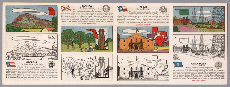
Author
[Fisher, Joseph R., Planters Peanuts (Firm)]
Full Title
Georgia : The empire state of the south -- Florida : The peninsula state -- Texas : The lone star state -- Oklahoma : The sooner state.
List No
14374.007
Note
Four views, representing Georgia, Florida, Texas and Oklahoma. Views show examples of the landscape and natural resources. Each view includes an inset map of the state, which marks the location of the capital city with a star. Accompanied by descriptive text, the state flags, seals and flowers: Cherokee rose, orange blossom, bluebonnet and mistletoe, respectively. The view of each state appears both in color (on top) and in black and white (bottom), the latter inviting coloration. Together, views are 18 x 52 cm, on two sheets 20 x 54 cm.
Author
[National U. S. 66 Highway Association, Andrews, Willard]
Full Title
Follow U. S. 66 across the Texas Panhandle and beautiful Oklahoma. Willard Andrews.
List No
14283.005
Note
Road map of Highway 66, from Glenrio, Texas to Bristow, Oklahoma. Includes a panoramic illustration featuring scenery along the way. With photographs in top and bottom margins, highlighting tourist sites, such as Light House, Palo Duro Canyon. Unfolded to 23 x 41 cm.
Author
Hoffman & Walker
Full Title
Hoffman & Walker's Pictorial Historical Map of Texas.
List No
10831.000
Note
Copyright Hoffman & Walker, PO Box No. 18456 Houston 23, Texas. Date estimated.
Author
Cram, George Franklin, 1841-1928
Full Title
Railroad and county map of Texas. Geo. F. Cram, engraver and publisher, Chicago.
List No
14250.053
Note
Map of Texas, showing railroads (both finished and unfinished), county boundaries, cities and towns, post offices, drainage and coastline. Political boundary lines in color. Includes a legend and a bar scale. With index numbers along the perimeter, and decorative border. Also, with an inset map: [Northern Texas]. 41 x 55 cm, on sheet 45 x 58 cm.
Author
H.M. Gousha Company
Full Title
1937 road map of Texas. Prepared exclusively for the Standard Oil Company of Texas. Copyright by the H.M. Gousha Company, Chicago, Ill. Printed in U.S.A. 282-S.C. (to accompany) Standard Oil road map. C.J. Moody.
List No
9875.010
Note
Color map, double page. Shows roads, highways, trails, state parks, monuments, national forests, airports, drainage, distances, places of interest, etc. Includes legend and index to cities and towns. Includes RPM Motor Oil logo. Relief shown by hachures and spot heights.
Author
[Berghaus, Heinrich, 1797-1884, Sohr, Karl, Flemming, Carl]
Full Title
Texas. Druck u. Verlag v. C. Flemming in Glogau. (to accompany) Vollstandiger Universal-Handatlas der neueren Erdbeschreibung ,,, Heinrich Berghaus ... 1859.
List No
13250.129
Note
Hand colored in outline map, with inset" Plan der Galveston Bay. Relief shown by hachures. Prime meridians are Paris and Ferro.
Author
[Johnston, Joseph E., Marcy, R. B., Simpson. James H., Whiting, W.H.C.]
Full Title
Reconnoissances of routes from San Antonio De Bexar to El Paso Del Norte, & cc., & cc., by Bvt. Lt. Col. J.E. Johnston, T. Eng'rs., Lt. W.f. Smith, Lt. F.T. Bryan, Lt. N.H. Michler, including the reconnoissance of Lt. W.H.C. Whiting, U.S. Eng'n. 1849. P.S. Duval's Lith. Steam Press. (to accompany) Reports of the secretary of war, with reconnaissances of routes from San Antonio to El Paso ... 1850.
List No
0380.005
Note
Map shows Shows expedition routes in color. Relief shown by form lines and hachures.In upper margin: Senate Ex. Doc. 1st Sess. 31st Cong. No. 64.
Author
Obert, Don D.
Full Title
A pictorial sketch of Texas : Showing State parks. Don-D-Obert. Del Ft. Worth 1939.
List No
13133.000
Note
Pictorial map of Texas, borders with vignettes. Shows major cities, landmarks, roads, farms, parks, industry, agriculture, rivers, mountains, recreational activities, and forts. Relief shown pictorially. A scarce pictorial map of Texas, only one other copy located online.
Author
[Meyer, Joseph, 1796-1856, Grassl, J.]
Full Title
Vereinigte Staaten von Nord-America : Californien, Texas und die Territorien New Mexico u. Utah. Nach den neuesten Hulfsmitteln gezeich von J. Grassl. 1852. (in upper margin) Meyer's Zeitung Atlas. No. 120. (to accompany) Neuester Zeitungs-Atlas fur Alte und Neue Erdkunde. Herausgegeben von J. Meyer.
List No
11652.098
Note
Engraved outline hand color map. Shows administrative boundaries, cities and towns, the gold region in California, Texas truncated by an enlarged New Mexico. Relief shown by hachures. Depth shown by isolines. Prime meridians are Greenwich and Washington.
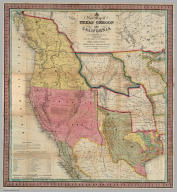
Author
Mitchell, Samuel Augustus
Full Title
A New Map of Texas Oregon and California With The Regions Adjoining. Compiled from the most recent authorities. Philadelphia Published by Thomas, Cowperthwait & Co. Market St. No. 253. 1849.
List No
10131.001
Note
Second edition. With 76 page "Description of Oregon and California, Embracing an account of the Gold Regions...;" The full color map is folded into stamped black leather covers 13.5x8 with "Texas, Oregon And California" in gilt. This was one of Mitchell's most popular and important pocket maps. Other editions were published in 1846, 1851, and 1852, as pocket maps and as insets to the large Reference and Distance Map of the United States. It was also issued separately as a wall map. This issue has the gold regions outlined and labeled in California and an inset map "Maritime and Overland Routes to California" and a second inset map "Map of the Gold and Quicksilver District of California." Mitchell first issued this map as an inset to his Reference and Distance Map of the United States in the 1846 edition (see our copy).
Author
Mitchell, Samuel Augustus
Full Title
(Covers to) A New Map of Texas Oregon and California With The Regions Adjoining. Compiled from the most recent authorities. Philadelphia Published by Thomas, Cowperthwait & Co. Market St. No. 253. 1849.
List No
10131.002
Note
Second edition. With 76 page "Description of Oregon and California, Embracing an account of the Gold Regions...;" The full color map is folded into stamped black leather covers 13.5x8 with "Texas, Oregon And California" in gilt. This was one of Mitchell's most popular and important pocket maps. Other editions were published in 1846, 1851, and 1852, as pocket maps and as insets to the large Reference and Distance Map of the United States. It was also issued separately as a wall map. This issue has the gold regions outlined and labeled in California and an inset map "Maritime and Overland Routes to California" and a second inset map "Map of the Gold and Quicksilver District of California." Mitchell first issued this map as an inset to his Reference and Distance Map of the United States in the 1846 edition (see our copy).
Author
Mitchell, Samuel Augustus
Full Title
A New Map of Texas Oregon and California With The Regions Adjoining. Compiled from the most recent authorities. Philadelphia Published by Thomas, Cowperthwait & Co. Market St. No. 253. 1849.
List No
10131.003
Note
Second edition. With 76 page "Description of Oregon and California, Embracing an account of the Gold Regions...;" The full color map is folded into stamped black leather covers 13.5x8 with "Texas, Oregon And California" in gilt. This was one of Mitchell's most popular and important pocket maps. Other editions were published in 1846, 1851, and 1852, as pocket maps and as insets to the large Reference and Distance Map of the United States. It was also issued separately as a wall map. This issue has the gold regions outlined and labeled in California and an inset map "Maritime and Overland Routes to California" and a second inset map "Map of the Gold and Quicksilver District of California." Mitchell first issued this map as an inset to his Reference and Distance Map of the United States in the 1846 edition (see our copy).
Author
Rand, McNally & Co.
Full Title
Texas.
List No
9733.145
Author
[Sohr, Karl, Flemming, Carl]
Full Title
Mexico, Mittel America, Texas.
List No
5200.071
Author
[Chirpe, W Rodney, Montgomery Ward Co., Inc.]
Full Title
Texas Centennial Exposition 1830-1936 : presented by Montgomery Ward. Designed by W. Rodney Chirpe. Copyright 1936 by Montgomery Ward Co., Inc.
List No
11641.000
Note
Color pictorial map of Texas, Includes historical vignettes on both sides and lower panels, historical notes and decorative compass rose oriented with the north to upper right margin. Shows landmarks, roads, farms, railroads, park, industry, agriculture, rivers, mountains and Native American settlements. Relief shown pictorially. Centennial Exposition was held at Fair Park in Dallas, to celebrate the 100th anniversary of Texas's independence from Mexico in 1836. It was also a celebration of Texas and Western culture. W. Rodney Chirpe was an artist who achieved some success in commercial and advertizing design. His work was featured in an exhibit at the Art Institute of Chicago in 1934.
Author
[Pages, Pierre Marie François, 1748-1793, Bernard, Robert]
Full Title
Carte d'une partie de l'Amerique Septentrionale : qui contient partie de la Nle. Espagne, et de la Louisiane, pour servir aux voyages au tour du Monde et vers les deux Poles, faits par M. de Pages ... ; Benard direxit. (to accompany) Atlas Les voyages de Pages (from ) Pages' Voyages autour du Monde, et vers les deux Poles.
List No
11230.003
Note
Uncolored map, showing part of Louisiana, Texas, the Gulf Coast and Mexico. Showing exploration routes, settlements, villages, missions, and rivers. Relief shown pictorially. Includes legend. Pages accompanied the Spanish Governor of Texas on a Journey from New Orleans to Natchitoches and on to San Antonio by way of the Red River in 1767. The book includes a 15 page account of Texas. Humboldt notes Pages' visit to Saltillo in 1767 in his seminal work on New Spain. The map tracks Pages journey from New Orleans to Acapulco, first up the Red River, then overland, identifying a number of Missions and other settlements and Indian Villages in Texas and Louisiana.
Author
Arrowsmith, Aaron
Full Title
(Covers to) A New Map of Mexico and Adjacent Provinces Compiled from Original Documents by A. Arrowsmith. 1810. London. Published 5th October 1810 by A. Arrowsmith, 10 Soho Sque. Hydrographer to H.R.H. the Prince of Wales. Engraved by E. Jones. (with) three inset maps: Valley of Mexico, from Mr. Humboldt's Map; Veracruz; and Acapulco.
List No
2035A
Note
All four covers have labels affixed stating: "Ch. Picquet, Geographe ordinaire DU ROI et de S.A.S. Monseign. le Duc d'Orleans. A Paris, Quai de Conti No. 17, entre l'Hotel des Monnaies et le Pont de Arts."
Author
[Arrowsmith, Aaron, Humboldt, Alexander von, 1769-1859]
Full Title
A New Map of Mexico and Adjacent Provinces Compiled from Original Documents by A. Arrowsmith. 1810. London. Published 5th October 1810 by A. Arrowsmith, 10 Soho Sque. Hydrographer to H.R.H. the Prince of Wales. Engraved by E. Jones. (with) three inset maps: Valley of Mexico, from Mr. Humboldt's Map; Veracruz; and Acapulco.
List No
2035.001
Note
Map in outline color.
Author
Colton, J.H.
Full Title
(Covers to) Texas. Published by J.H. Colton & Co. No. 171 William St. New York. Entered according to Act of Congress in the year 1855, by J.H. Colton & Co. ... New York (insets) Plan of Galveston Bay -- Plan of Sabine Lake.
List No
6823.001
Note
Rare first edition of the Colton map of Texas in pocket map form. Outline color map, 31 1/2x40 folded and bound in brown cover, 10 1/2x8 1/2 with "Map of Texas, J.H. Colton" stamped in gilt. Relief shown by hachures. Prime meridians are Greenwich and Washington. On verso of cover: J.H. Colton's geographical Publishing advertisement. Includes note and explanation. Showing roads, railroads, cities and towns.
Author
Colton, J.H.
Full Title
Texas. Published by J.H. Colton & Co. No. 171 William St. New York. Entered according to Act of Congress in the year 1855, by J.H. Colton & Co. ... New York (insets) Plan of Galveston Bay -- Plan of Sabine Lake.
List No
6823.002
Note
Rare first edition of the Colton map of Texas in pocket map form. Outline color map, 31 1/2x40 folded and bound in brown cover, 10 1/2x8 1/2 with "Map of Texas, J.H. Colton" stamped in gilt. Relief shown by hachures. Prime meridians are Greenwich and Washington. On verso of cover: J.H. Colton's geographical Publishing advertisement. Includes note and explanation. Showing roads, railroads, cities and towns.
Author
[Bruff, J. Goldsborough, Disturnell, John]
Full Title
(Covers to) A Correct Map Of The Seat Of War In Mexico. Being a Copy of Genl. Arista's Map, taken at Resaca de la Palma, with additions and Corrections ... New York: Published By J. Disturnell. 102, Broadway, 1847. Designed by J.G. Bruff Washington D.C. Entered ... 1847, by J.G. Bruff ... New York. Lith. of E. Jones & G.W. Newman, 128, Fulton St. On Stone by J. Probst. (with 4 inset maps).
List No
0097A
Author
[Bruff, J. Goldsborough, Disturnell, John]
Full Title
A Correct Map Of The Seat Of War In Mexico. Being a Copy of Genl. Arista's Map, taken at Resaca de la Palma, with additions and Corrections ... New York: Published By J. Disturnell. 102, Broadway, 1847. Designed by J.G. Bruff Washington D.C. Entered ... 1847, by J.G. Bruff ... New York. Lith. of E. Jones & G.W. Newman, 128, Fulton St. On Stone by J. Probst. (with 4 inset maps).
List No
0097.001
Note
Scarce map with Drawings by Bruff. According to Tooley, Bruff did: State of Florida, 1846; this map; Tehuantepec maps, 1851; Seat of War in Virginia, 1861. In Phillips p410, this map and another smaller map also published by Disturnell are listed. From the Introduction to his travel diary, it is clear that Bruff drew for the Topographical Engineers and other government departments for over 50 years. Many of his products may not have his name on them - he is quoted in the introduction (page xxx) saying that he drew duplicates of the Fremont maps and plates for both houses of Congress. The four inset maps are titled: Plan of Monterey, Map Showing the Battle Grounds of the 8th and 9th May 1846, Tampico and its Environs, and Chart of the Bay of Vera Cruz. Map is folded into brown cloth covers 15x10 with "Map Of The Seat Of War In Mexico." stamped in gilt.
Author
Emory, William H.
Full Title
(Covers to) Map Of Texas And The Countries Adjacent: Compiled In The Bureau Of The Corps Of Topographical Engineers, Fom The Best Authorities, For the State Department, Under the direction of Colonel J.J. Abert, Chief of the Corps; by W.H. Emory, 1st Lieut. T.E. War Department 1844. W.J. Stone Sc. Washn. Published by order of the U.S. Senate.
List No
0262A
Author
Emory, William H.
Full Title
Map Of Texas And The Countries Adjacent: Compiled In The Bureau Of The Corps Of Topographical Engineers, Fom The Best Authorities, For the State Department, Under the direction of Colonel J.J. Abert, Chief of the Corps; by W.H. Emory, 1st Lieut. T.E. War Department 1844. W.J. Stone Sc. Washn. Published by order of the U.S. Senate.
List No
0262.001
Note
In original paper wrapper. From a descendent of Rhode Island Senator John Brown Francis, who had a few copies in the attic in the original paper wraps with the red seal. First separate U.S. Government map of Texas. With outline color around the state of Texas.
Author
Mitchell, Samuel Augustus
Full Title
(Covers to) A New Map of Texas Oregon and California With The Regions Adjoining. Compiled from the most recent authorities. Philadelphia Published by S. Augustus Mitchell N.E. Corner Of Market & Seventh Streets. 1846. Entered ... 1845 by H.N. Burroughs ... Pennsylvania.
List No
0534A
Author
Mitchell, Samuel Augustus
Full Title
A New Map of Texas Oregon and California With The Regions Adjoining. Compiled from the most recent authorities. Philadelphia Published by S. Augustus Mitchell N.E. Corner Of Market & Seventh Streets. 1846. Entered ... 1845 by H.N. Burroughs ... Pennsylvania.
List No
0534.001
Note
With 46 page "Accompaniment to Mitchell's New Map Of Texas, Oregon, and California With The Regions Adjoining;" the full color map is folded into stamped black leather covers 13.5x8 with "Texas, Oregon And California" in gilt. This was one of Mitchell's most popular and important pocket maps. Later editions were published in 1849, 1851, and 1852, as pocket maps and as insets to the large Reference and Distance Map of the United States. It was also issued separately as a wall map. This issue has Texas colored green; some copies have Texas colored brown (has the green changed over time?). The text has a catalogue for Mitchell's publications. Mitchell first issued this map as an inset to his Reference and Distance Map of the United States in the 1846 edition (see our copy).
Author
U.S. War Department
Full Title
(Covers to) Engineer Bureau, War Department. Map Of The States Of Kansas And Texas And Indian Territory, With Parts Of The Territories Of Colorado And New Mexico. From the most recent official surveys and explorations and other authentic information. 1867. J. Bien, Lith. 24 Vesey St. N.Y.
List No
2320A
Author
U.S. War Department
Full Title
Engineer Bureau, War Department. Map Of The States Of Kansas And Texas And Indian Territory, With Parts Of The Territories Of Colorado And New Mexico. From the most recent official surveys and explorations and other authentic information. 1867. J. Bien, Lith. 24 Vesey St. N.Y.
List No
2320.001
Note
1st edition. Not in Streeter, Phillips, Wheat. Map shows routes of important reconnaissances, Indian trails, roads, railroads in operation, projected railroads, army routes, Indian lands and reservations. One of the earliest detailed Army surveys of the area. The map was printed in two sheets, a north sheet and a south sheet. The north sheet appears in the Atlas to Accompany the Official Records of the Union and Confederate Armies as Plate CXIX, with the same title as this map, but with the title placed in the upper right corner of the north sheet. We also have the North sheet without title, dated c1875, with much additional information on new routes, railroads, etc. This map is signed by William E. Merrill, Maj. Engrs., and dated August 10, 1867. Merrill also signed our copy of the Warren Map of the U.S., 1867, with a signature date of August 26, 1867 Merrill later made maps of Kansas (See Karrow). Graff misspells Merrill's name, as does Streeter (his signature is hard to read). Dissected into 48 sections and mounted on linen. Map folds into two dark green cloth end boards 22.5x13.5 with paper label reading "Kansas, Texas, And Indian Territory, With Parts Of Colorado And New Mexico. Engineer Bureau, W.D. Prepared for Issue in Engineer Office, M.D. Mo. All Person Into Whose Hands The Map Falls Are Particularly Requested To Send All Corrections And Additions To The Chief Engineer, Mil. Div. Of The Mo., St. Louis." With hand painted color.
Author
[Colton, J. H., Creuzbaur, Robert, De Cordova, Jacob]
Full Title
(Covers to) J. De Cordova's Map Of The State Of Texas Compiled from the records of the General Land Office of the State by Robert Creuzbaur, Revised and Corrected by Charles W. Pressler. Published by J.H. Colton & Co. No. 172 William St. New York 1856. Engraved by J.M. Atwood, New York. Entered ... 1856 by J. De Cordova ... Texas. (with untitled inset of southwestern U.S.).
List No
3366A
Author
[Colton, J. H., Creuzbaur, Robert, De Cordova, Jacob]
Full Title
J. De Cordova's Map Of The State Of Texas Compiled from the records of the General Land Office of the State by Robert Creuzbaur, Revised and Corrected by Charles W. Pressler. Published by J.H. Colton & Co. No. 172 William St. New York 1856. Engraved by J.M. Atwood, New York. Entered ... 1856 by J. De Cordova ... Texas. (with untitled inset of southwestern U.S.).
List No
3366.001
Note
First edition of Pressler's revision of De Cordova's map, and first edition published by Colton. Shows Texas east of the 102nd meridian. First issued by De Cordova in 1849, with editions of 1850, 51, 53, 56, 57, 58, and 61 (Ristow and Rosenberg), and a late unlisted edition in 1867 (see our #4801). De Cordova employed Pressler to revise the map in 1855 and then sold the rights to Colton in the same year. The 1849 edition has only two copies located. Eberstadt called the 1849 issue "possibly the finest (Texas map) of the period." Colton changed the inset map from the oval showing all of Texas to the southwestern portion of Colton's U.S. atlas map. J.M. Atwood was the engraver of all editions. With a list of the Land districts, this map was useful for both land promoters and settlers. Colton published a reduced version of the map in his 1856 Atlas of the World. The full color map is folded into stamped dark maroon leather covers 16x10.5 with "J. De Cordova's Texas J.H. Colton & Co. New York." in gilt.
Author
Houston And Texas Central Railway
Full Title
(Covers to:) Houston and Texas Central Railway through Texas. Northern to southern boundary and with branches and Texas Central Railway through central and western Texas ... 461-July-85. Rand, McNally & Co., Printers, Chicago.
List No
5237A
Note
Self wrappers with text, view and timetable.
Author
Houston And Texas Central Railway
Full Title
Houston and Texas Central Railway through Texas. Northern to southern boundary and with branches and Texas Central Railway through central and western Texas ... 461-July-85. Rand, McNally & Co., Printers, Chicago.
List No
5237B
Note
Self wrappers with text, view and timetable.
Author
Houston And Texas Central Railway
Full Title
Texas and Mexico showing Houston and Texas Central system of railways. Rand, McNally & Co, Engr's, Chicago. (inset) Map of United States and Mexico reduced scale; showing the Houston and Texas Central Railway and connections. (1885)
List No
5237.001
Note
Col. map. Includes statistical table: Counties traversed by the Houston & Texas Central Railway
Author
Appleton, D. & Co.
Full Title
Map of Texas, Oklahoma and Indian Territory. Copyright 1891 by Matthews-Northrup Co. ... Buffalo, New York. (inset) Western part of Texas. (to accompany) The Library Atlas Of Modern Geography ... New York, D. Appleton And Company 1892. (on upper margin) Texas, Oklahoma and Indian Territory 98.
List No
0026.250
Note
Color map. Shows state and county boundaries and county seat, capital, Indian Reservations, railways, roads, rivers, etc. "Size of type indicates importance of the places". Includes notes. Prime meridians are Greenwich and Washington. Relief shown by hachures.
Author
Arbuckle Bros.
Full Title
Indian Territory, New Mexico, South Dakota, Texas. Copyright 1889 Arbuckle Bros. N.Y.
List No
0027.005
Note
Sheet with maps of four states in full color. "Indian Territory" is now known as Oklahoma. It is noted that, "Of the 41,000,000 acres in the Territory, nearly 26,000,000 have been surveyed and set apart as reservations for the Indians. These have been gathered from all parts of the country, from Oregon to Florida, in pursuance of the general plan of congregating all the Indians in one territory, to be theirs forever." Each card measures 7.5 x 12.5 cm.
Author
Asher & Adams
Full Title
Asher & Adams' Indian Territory and Texas north west portion. Entered according to Act of Congress in the year 1874 by Asher & Adams ... at Washington. (New York, 1874)
List No
0041.015
Note
Hand col. engraved map. Easternmost Indian Territory shown on pages 51-52 of this atlas. Shows townships, distances along railroads, etc. Prime meridians: Greenwich and Washington.
Author
Asher & Adams
Full Title
Asher & Adams' Texas eastern portion. Entered according to Act of Congress in the year 1874 by Asher & Adams ... at Washington. (New York, 1874)
List No
0041.016
Note
Hand col. engraved map. Includes inset map. Shows distances along railroads, etc. Prime meridians: Greenwich and Washington.
Author
Asher & Adams
Full Title
Asher & Adams' Texas western portion. Entered according to Act of Congress in the year 1874 by Asher & Adams ... at Washington. (New York, 1874)
List No
0041.017
Note
Hand col. engraved map. Includes inset map. Prime meridians: Greenwich and Washington.
Author
Asher & Adams
Full Title
(Composite of) Asher & Adams' Texas ... Entered according to Act of Congress in the year 1874 by Asher & Adams ... at Washington. (New York, 1874)
List No
0041.018
Note
Composite map on 2 sheets. Hand col., engraved. Easternmost Indian Territory shown on pages 51-52 of this atlas. Includes 2 inset maps. Shows townships, distances along railroads, etc. Prime meridians: Greenwich and Washington.
Author
[Bartholomew, John, Black, Adam & Charles]
Full Title
Texas, Part of New Mexico. Published by A. & C. Black. Edinburgh. Printed in Colours by Schenck & Macfariane. Edinburgh. Drawn & Engraved by J. Bartholomew, Edinburgh.
List No
0073.017
Note
States outlined in color. Land tinted.
Author
[Bartholomew, John, Black, Adam & Charles]
Full Title
Western States, including California, Oregon, Utah, Washington, New Mexico, Nebraska, Kansas, Indian Territory, &c. Published by A. & C. Black. Edinburgh. Printed in Colours by Schenck & Macfariane. Edinburgh. Drawn & Engraved by J. Bartholomew, Edinburgh.
List No
0073.018
Note
States outlined in color. Land tinted.
|


![Mapa del Rio Grande desde su desembocadura en el golfo hasta San Vicente, Presidio Antiguo. Mandado formar por el primer miembro de la Comisi6n Pesquisidora de la Frontera del Norte, conforme 6 las noticias recojidas en el Expediente 4°-, Sefi.al{mdose los ranchos que hay por ambas orillas del Rio Grande, y los pueblos que la Comisi6n ha visitado anotandose estos con la linea roja .. Monterey Diciembre 1[8]73 M.J. Martinez](https://www.davidrumsey.com/rumsey/Size1/RUMSEY~8~1/205/15614004.jpg)
![A Map of the Indian Territory Northern Texas and New Mexico Showing the [Great Western Prairies by Josiah Gregg [below neat line at left] Entered according to Act of Congress in the year 1844 by Sidney E. Morse and Samuel Breese in the Clerks Office of the Southern District of New York.](https://www.davidrumsey.com/rumsey/Size2/RUMSEY~8~1/205/15614005.jpg)


![Reconnoissances [sic] of routes from San Antonio De Bexar to El Paso Del Norte, & cc.](https://www.davidrumsey.com/rumsey/Size2/RUMSEY~8~1/179/0380005.jpg)