|
Author
United States. Post Office Department
Full Title
Post Route Map of the State of Missouri.
List No
15916.002
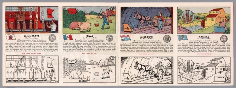
Author
[Fisher, Joseph R., Planters Peanuts (Firm)]
Full Title
Minnesota : The gopher state -- Iowa : The hawkeye state -- Missouri : The show me state -- Kansas : The sunflower state.
List No
14374.011
Note
Four views, representing Minnesota, Iowa, Missouri and Kansas. Views show examples of the landscape and natural resources. Each view includes an inset map of the state, which marks the location of the capital city with a star. Accompanied by descriptive text, the state flags, seals and flowers: moccasin flower, wild rose, hawthorne and sunflower, respectively. The view of each state appears both in color (on top) and in black and white (bottom), the latter inviting coloration. Together, views are 18 x 52 cm, on two sheets 20 x 54 cm.
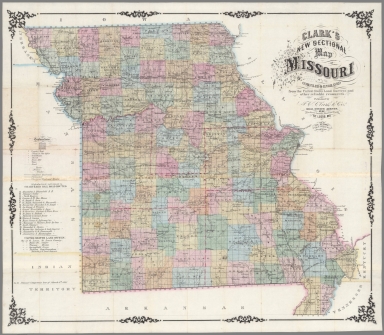
Author
[J.C. Clark & Co., Hutawa, Julius]
Full Title
Clark’s New Sectional Map of Missouri compiled & engraved from the United States land surveys and other reliable sources.
List No
15110.002
Author
[National U. S. 66 Highway Association, Andrews, Willard]
Full Title
Follow U. S. 66 across Missouri, the "Show Me State" ... Play in the Ozarks ... See Illinois. Willard Andrews.
List No
14283.006
Note
Road map of Highway 66, from Sapulpa, Oklahoma to Chicago, Illinois. Includes a panoramic illustration featuring scenery along the way. With photographs in top and bottom margins, highlighting tourist sites, such as Underland Wonderland. Unfolded to 23 x 41 cm.
Author
Cram, George Franklin, 1841-1928
Full Title
New railroad and county map of Missouri : Showing latest government surveys. Published by Geo. F. Cram, 262-264 Wabash Ave. Chicago. 1882.
List No
14250.022
Note
Map of Missouri, showing railroads (both proposed and existing), county boundaries, cities and towns, and drainage. Political boundary lines in color. Includes a legend and a bar scale. With index numbers along the perimeter, and decorative border. Also, with two inset maps: The south-eastern extension of Missouri -- [St. Louis and vicinity]. 42 x 52 cm, on sheet 45 x 58.
Author
United States. Post Office Department
Full Title
Upper Part. Post Route Map of States of Illinois, Iowa and Missouri with Adjacent Parts of Indiana, Wisconsin, Minnesota, Nebraska, Kansas, and Arkansas.
List No
10439.002
Note
Updated to 1879 from 1872. 8 panels.
Author
United States. Post Office Department
Full Title
Lower Part. Post Route Map of States of Illinois, Iowa and Missouri with Adjacent Parts of Indiana, Wisconsin, Minnesota, Nebraska, Kansas, and Arkansas.
List No
10439.004
Note
Updated to 1879 from 1872. 8 panels.
Author
United States. Post Office Department
Full Title
(Composite Map) Post Route Map of States of Illinois, Iowa and Missouri with Adjacent Parts of Indiana, Wisconsin, Minnesota, Nebraska, Kansas, and Arkansas.
List No
10439.005
Note
Updated to 1879 from 1872. 8 panels.
Author
Cram, George Franklin
Full Title
(Covers to) New Rail Road & township map of Missouri and Kansas : Published by Geo. F. Cram & Co. Western Map Depot. 148 Lake Street, Chicago Ills.
List No
7827.001
Note
Regional Cram's pocket map, 1st. edition. With full color map, 37X79, with 3 vignettes. Folded into black cloth covers 14x9 with "New Rail-Road & Township Map Of Kansas and Missouri : Published By Geo. F. Cram & Co." in gilt. Geo. F. Cram & Co. advertisement on verso of front cover.
Author
Cram, George Franklin
Full Title
New Rail Road & township map of Missouri and Kansas : Published by Geo. F. Cram & Co. Western Map Depot. 148 Lake Street, Chicago Ills.
List No
7827.002
Note
Outline color regional map, with 3 vignettes. Folded into black cloth covers 14x9 with "New Rail-Road & Township Map Of Kansas and Missouri : Published By Geo. F. Cram & Co." in gilt. Identifies counties and clearly shows railroad lines.
Author
Paul, Rene
Full Title
(Covers to) Map Of The City Of St. Louis Compiled from information in the possession of Rene Paul Esqr. 1844. Published By Twichel & Cook N.W. Cor. Main & Pine Sts. St. Louis Mo. Engraved at the Office of J.T. Hammond, By T. Twichel. N.W. Cor. Main & Pine Streets. St. Louis Mo.
List No
4197A
Author
Paul, Rene
Full Title
Map Of The City Of St. Louis Compiled from information in the possession of Rene Paul Esqr. 1844. Published By Twichel & Cook N.W. Cor. Main & Pine Sts. St. Louis Mo. Engraved at the Office of J.T. Hammond, By T. Twichel. N.W. Cor. Main & Pine Streets. St. Louis Mo.
List No
4197.001
Note
Second edition. In covers with printed paper label "Map of the City of St. Louis, 1844." Engraved map, with three vignettes, two of buildings and one of a steamboat on the Mississippi River. Table of population statistics and a key to the important buildings located on the map. Color coded by ward. A beautiful map, exquisitely colored, and scarce. Rene Paul, the city surveyor, first issued this map in 1842. In 1835 Paul did a larger map of St. Louis separately and for Eugene Charles Dupre's Atlas of the City and County of St. Louis (illustrated in Ristow p.296, Karrow 9-1553-4). This earlier map was lithographed by Lehman & Duval. Folded into dark brown cloth covers 13x8 with "Map Of The City Of St. Louis, 1844" printed in black on yellow paste down label.
Author
Appleton, D. & Co.
Full Title
Map of Missouri. Copyright 1891 by Matthews-Northrup Co. ... Buffalo, New York. (inset) City of St. Louis. (to accompany) The Library Atlas Of Modern Geography ... New York, D. Appleton And Company 1892. (on upper margin) Missouri. 79.
List No
0026.202
Note
Color map. Shows county boundaries and county seat, capital, railways, roads, etc. "Size of type indicates importance of the places". Includes notes. Relief shown by hachures. Prime meridians are Greenwich and Washington.
Author
Arbuckle Bros.
Full Title
Missouri, Oregon, Iowa, North Dakota. Copyright 1889 Arbuckle Bros. N.Y.
List No
0027.003
Note
Sheet with maps of four states in full color. Oregon is noted for its salmon fisheries, and the card features a fisherman as well as canned salmon. Little is written about North Dakota, but it is noted that "the temperature varies from 20 degrees below zero to 100 degrees Fahrenheit." Each card measures 7.5 x 12.5 cm.
Author
Asher & Adams
Full Title
Asher & Adams' Missouri. Entered according to Act of Congress in the year 1874 by Asher & Adams ... at Washington. (New York, 1874)
List No
0041.023
Note
Hand col. engraved map. Shows townships, distances along railroads, etc. Prime meridians: Greenwich and Washington.
Author
[Bartholomew, John, Black, Adam & Charles]
Full Title
Missouri and Arkansas. Published by A. & C. Black. Edinburgh. Printed in Colours by Schenck & Macfariane. Edinburgh. Drawn & Engraved by J. Bartholomew, Edinburgh.
List No
0073.013
Note
States outlined in color. Land tinted.
Author
Bradford, Thomas G.
Full Title
Missouri. Entered ... 1838, by T.G. Bradford ... Massachusetts. Engraved by G.W. Boynton.
List No
0089.036
Note
In full color.
Full Title
Carte geographique, statistique et historique du Missouri. Missouri. Grave par B. de Beaupre, Rue de Vaugirard, No. 81, a Paris. Fonderie et Imprimerie de J. Carez. (1825)
List No
0102.034
Note
Hand colored engraved map. Relief shown by hachures. Text and tables at sides and bottom. Prime meridians: Washington and Paris.
Author
Burr, David H., 1803-1875
Full Title
Map of Illinois & Missouri Exhibiting the Post Offices, Post Roads, Canals, Rail Roads, &c. By David H. Burr. (Late Topographer to the Post Office.) Geographer to the House of Representatives of the U.S. John Arrowsmith. Entered ... July 10th, 1839, by David H. Burr ... District of Columbia.
List No
0104.012
Note
In full color by county. Postal routes by coach, stage, sulkey, cross, rail roads and canals shown. In 8 sections mounted on linen. Label on back states "No. 12. Illinois, Missouri."
Author
[Carey, H. C., Lea, I.]
Full Title
Geographical, Historical, And Statistical Map Of Missouri. Missouri. No. 34. Engraved by Young & Delleker.
List No
0122.029
Note
In full color by county or region surrounded by text.
Author
[Carey, H. C., Lea, I.]
Full Title
Geographical, Historical, And Statistical Map Of Arkansas Territory. Map Of Arkansas And Other Territories of the United States Respectfully inscribed to the Hon. J.C. Calhoun Secretary Of War By S.H. Long Major T. Engineers. No. 35. Drawn by S.H. Long Maj. U.S. Engineers. Engraved by Young & Delleker.
List No
0122.030
Note
In full color by region surrounded by text.
Author
Colton, G.W.
Full Title
The City Of St. Louis Missouri. (with) The City Of Chicago Illinois. Published By J.H. Colton & Co. No. 172 William St. New York. Entered ... 1855 by J.H. Colton & Co. ... New York. No. 45.
List No
0149.050
Note
In full color by area. Numerous buildings are shown and labeled. Both maps inside decorative border.
Author
Colton, G.W.
Full Title
Missouri. (with) Vicinity Of St. Louis. Published By J.H. Colton & Co. No. 172 William St. New York. Entered ... 1855 by J.H. Colton & Co. ... New York. No. 46.
List No
0149.051
Note
In full color by county.
Author
Colton, G.W.
Full Title
Colton's Missouri. (inset) Vicinity of St. Louis. Published By J. H. Colton. No. 172 William St. New York.
List No
0151.056
Note
Prime meridians are Greenwich and Washington D.C. Map showing the county boundaries in color.
Author
Colton, G.W.
Full Title
The City of St. Louis, Missouri. The City of Chicago, Illinois. Published By J. H. Colton. No. 172 William St. New York.
List No
0151.057
Note
The plans of Chicago & St. Louis are upon the same scale.
Author
Colton, G.W.
Full Title
The City of St. Louis, Missouri. The City of Chicago, Illinois. Published By G. W & C. B. Colton & Co. No. 172 William St. New York.
List No
0152.055
Note
The plans of Chicago & St. Louis are upon the same scale.
Author
Colton, G.W.
Full Title
Colton's Missouri. (inset) Vicinity of St. Louis. Published By G. W & C. B. Colton & Co. No. 172 William St. New York.
List No
0152.056
Note
Prime meridians are Washington D.C. and Greenwich.
Author
Cram, George Franklin
Full Title
(Covers to) New Sectional Map Of The State Of Missouri. Engraved from Official Draughts of each County, Published by George F. Cram & Co. Proprietors Of The Western Map Depot. 148 Lake St., Chicago, Ill. 1870. Entered ... 1869 by George F. Cram ... Illinois.
List No
0202.001
Note
Second edition of the first Cram map of Missouri. Karrow shows only the 1869 and 1873 editions. With the 1860 census data for the state and ads for Cram's maps printed on three yellow pages attached to the inside front cover. Full color. Folded into dark brown cloth covers 14x9 with "New Sectional Map Of Missouri Published By Geo. F. Cram & Co." in gilt.
Author
Cram, George Franklin
Full Title
New Sectional Map Of The State Of Missouri. Engraved from Official Draughts of each County, Published by George F. Cram & Co. Proprietors Of The Western Map Depot. 148 Lake St., Chicago, Ill. 1870. Entered ... 1869 by George F. Cram ... Illinois.
List No
0202.002
Note
Second edition of the first Cram map of Missouri. Karrow shows only the 1869 and 1873 editions. With the 1860 census data for the state and ads for Cram's maps printed on three yellow pages attached to the inside front cover. Full color. Folded into dark brown cloth covers 14x9 with "New Sectional Map Of Missouri Published By Geo. F. Cram & Co." in gilt.
Author
Cram, George Franklin
Full Title
(Cover to) New Sectional Map Of The State Of Missouri. Engraved from Official Draughts of each County. Published by George F. Cram & Co. Proprietor Of The Western Map Depot. 148. Lake Street, Chicago, Ill. 1871. Entered ... 1869, by George F. Cram ... Illinois.
List No
0203.001
Note
Similar to the 1870 edition, but adds many new railroads built and projected, plus updates the census data to 1870. Full color. Folded into dark brown cloth covers 14x9 with "New Sectional Map Of Missouri Published By Geo. F. Cram & Co." in gilt.
Author
Cram, George Franklin
Full Title
New Sectional Map Of The State Of Missouri. Engraved from Official Draughts of each County. Published by George F. Cram & Co. Proprietor Of The Western Map Depot. 148. Lake Street, Chicago, Ill. 1871. Entered ... 1869, by George F. Cram ... Illinois.
List No
0203.002
Note
Similar to the 1870 edition, but adds many new railroads built and projected, plus updates the census data to 1870. Full color. Folded into dark brown cloth covers 14x9 with "New Sectional Map Of Missouri Published By Geo. F. Cram & Co." in gilt.
Author
Cram, George Franklin
Full Title
New Rail Road and County Map of Missouri.
List No
0210.033
Note
Prime meridians Greenwich and Washington.
Author
[Fiala, John T., Haren, Edward]
Full Title
(Covers to) Fiala And Haren's New Sectional Map of the State of Missouri. Published by Jas. M. Crawford. Books and Stationery No. 54, North 4th Street, St. Louis, Mo. 1865. Entered ... 1860, by Gray & Crawford ... Mo. Lith by Mackenzie And Gardner, Practical Lithographers, 51 Chestnut St. N.E. Cor. Of 3D.
List No
0276.001
Note
Rare St. Louis published map. Fiala was a civil engineer; apparently he did a map for Campbell's Atlas of Missouri. Full color by county. Map is folded into covers16x10 with original back cover of dark brown textured cloth, and a new gray cloth front with gold stamped title "Fiala And Haren's Missouri 1865".
Author
[Fiala, John T., Haren, Edward]
Full Title
Fiala And Haren's New Sectional Map of the State of Missouri. Published by Jas. M. Crawford. Books and Stationery No. 54, North 4th Street, St. Louis, Mo. 1865. Entered ... 1860, by Gray & Crawford ... Mo. Lith by Mackenzie And Gardner, Practical Lithographers, 51 Chestnut St. N.E. Cor. Of 3D.
List No
0276.002
Note
Rare St. Louis published map. Fiala was a civil engineer; apparently he did a map for Campbell's Atlas of Missouri. Full color by county. Map is folded into covers16x10 with original back cover of dark brown textured cloth, and a new gray cloth front with gold stamped title "Fiala And Haren's Missouri 1865".
Author
Finley, Anthony
Full Title
Map of the State of Missouri And Territory of Arkansas Compiled From The Latest Authorities. Drawn by D.H. Vance. Engraved by J.H. Young. Published by A. Finley Philadelphia 1826.
List No
0278.012
Note
In full color by county or region. Statistical table breaks down population from the 1820 census by white, blacks, and foreigners not naturalized. Square mileage also noted.
Author
Finley, Anthony
Full Title
Map of the State of Missouri and the Territory of Arkansas, Compiled from the Latest Authorities.
List No
0279.016
Note
Date estimated.
Author
Finley, Anthony
Full Title
Map of the States of Missouri and Territory of Arkansas, Compiled from the Latest Authorities. Drawn by D.H. Vance. Published by A. Finley, Philadelphia. Engraved by J.H. Young.
List No
0280.012
Note
Relief shown by hachures. Prime meridian Washington. Statistical table for each state.
Author
Finley, Anthony
Full Title
Missouri. Young & Delleker Sc. Published by A. Finley, Philada. (to accompany) A New General Atlas Comprising a Complete Set of Maps, representing the Grand Divisions Of The Globe ... Philadelphia: Published by Anthony Finley. 1827.
List No
0282.034
Note
Full color map on sheet 35x27. Relief shown pictorially. Prime meridians are Washington and Greenwich. Shows counties, major cities, roads and rivers.
Author
Finley, Anthony
Full Title
Missouri. Published by A. Finley Philada. Young & Delleker Sc.
List No
0285.030
Note
Full color by county.
Author
Gray, O.W.
Full Title
Gray's Atlas Map of Missouri.
List No
0310.062
Author
[Colton, G.W., Colton, C.B., Gray, O.W.]
Full Title
Missouri. Entered ... 1869 by G.W. & C.B. Colton & Co.
List No
0312.045
Author
Hutawa, Julius
Full Title
Map Of The State Of Missouri. Showing different Railroad Routes surveyed by the Pacific Railroad Compy. as reported to the Legislature of the State of Missouri in December 1852. Julius Hutawa Lithographer, Second Street, betw. Olive & Pine, St. Louis, Mo.
List No
0334.000
Note
From 3rd Annual Report of Pacific RR Company. Karrow lists the same map as published in the Missouri Republican. This map shows the first railroad surveys made or to be made in the state. Without color.
Author
Johnson, A.J.
Full Title
Johnson's Missouri And Kansas By Johnson And Ward.
List No
0352.039
Note
Full color by county or region, with heavy outlines around the states. Includes three vignettes: Santa Fe from the Great Missouri Trail, Spearing Fish, and Fire on the Prairie. Shows railroads, roads, and Indian reservations. Prime meridians are Greenwich and Washington D.C. Relief shown by hachures.
Author
Johnson, A.J.
Full Title
Johnson's Missouri and Kansas. Entered ... 1865.
List No
0358.044
Author
Leahy, J.F.
Full Title
(Index to) Leahy's Hotel Guide and Railway Distance Maps. Missouri.
List No
0425.068
Note
Alphabetical index list of the Hotels of the town with the number of rooms of each, their rates per day and the population of the town. Includes population of the states, Explanation of abbreviation of the railroad of the state, and advertisements.
Author
Leahy, J.F.
Full Title
Leahy's Hotel Guide and Railway Distance Map of the State of Missouri. Published by American Hotel Register Company. Leahy Build., 228-234 W. Ontario St., Chicago, Ill. Copyrighted by J.F. Leahy, Jan., 1934.
List No
0425.069
Note
Map printed without color. Includes name of the railroad entering the town, and distance between towns.
Author
Leahy, J.F.
Full Title
(Index to) Leahy's Hotel Guide and Railway Distance Maps. Missouri.
List No
0425.070
Note
Alphabetical index list of the Hotels of the town with the number of rooms of each, their rates per day and the population of the town. Includes population of the states, Explanation of abbreviation of the railroad of the state, and advertisements.
Author
Leahy, J.F.
Full Title
Leahy's Hotel Guide and Railway Distance Map of the State of Missouri. Published by American Hotel Register Company. Leahy Build., 228-234 W. Ontario St., Chicago, Ill. Copyrighted by J.F. Leahy, Jan., 1934. (inset map) Southeastern Part of Missouri.
List No
0425.071
Note
Map printed without color. Includes name of the railroad entering the town, and distance between towns.
Author
Matthews-Northrup
Full Title
(Covers to) The Matthews-Northrup Up-To-Date Map of Missouri. Published Indexed Vest-Pocket Style ... Copyright, 1895, by The Matthews-Northrup Co., Complete Engraving and Printing Works, Buffalo, N.Y.
List No
0470.001
Note
Printed full color by county, folded into red card board covers 13.5x6 with "The Matthews-Northrup Up-To-Date Map Missouri Indexed Vest Pocket Series. All States And Territories, 18 Chief Cities And Canada ... "They give all there is, - what more do you want?" For List and Prices See Inside Cover Pages." stamped in black. (on verso) "Index and Population." Prime meridians are Washington D.C. and Greenwich.
Author
Matthews-Northrup
Full Title
(Index page to) The Matthews-Northrup Up-To-Date Map of Missouri. Published Indexed Vest-Pocket Style ... Copyright, 1895, by The Matthews-Northrup Co., Complete Engraving and Printing Works, Buffalo, N.Y.
List No
0470.002
Note
Printed full color by county, folded into red card board covers 13.5x6 with "The Matthews-Northrup Up-To-Date Map Missouri Indexed Vest Pocket Series. All States And Territories, 18 Chief Cities And Canada ... "They give all there is, - what more do you want?" For List and Prices See Inside Cover Pages." stamped in black. (on verso) "Index and Population." Prime meridians are Washington D.C. and Greenwich.
|