|
Author
[White, Ruth Taylor, Western Air Express]
Full Title
San Francisco -Los Angeles : 365 miles - 3 hours. The World's model Air Line. Cartograph by Ruth Taylor White. (to accompany) Western Air Express Travel by Air : Travel by Western Air Express : Speend - comfort - dependability. Cartograph by Ruth Taylor White. Printed in U.S.A. in October, 1929.
List No
11777.002
Note
Double page pictorial map. Showing Western Air express route, flying times and distance, major cites landmarks, forest, winter and Summer sports, recreational activities, places of interest, industry, farms, rivers and mountains. Relief shown pictorially. Includes photo of a Tri-motored Fokker type aircraft, compass rose decorated with arrowhead logo and text "San Francisco- Los Angeles line of the Western Air Express ... established in May 1928 ..."
Author
[H.M. Gousha Company, Standard Oil Company of California]
Full Title
Map of San Francisco and vicinity prepared for Standard Oil Company of California. Copyright by the H.M. Gousha Company, Chicago-San Jose.
List No
15208.002
Note
Relief shown by shading and spot heights. Indexed. Includes mileage chart. Map is printed in full color and folds into self wrappers 23 x 10. Inset map of downtown San Francisco shows the newly completed Central Freeway. See our 3264.000 for the 1953 edition of this map that shows the freeway under construction.
Author
[H.M. Gousha Company, Standard Oil Company of California]
Full Title
Street map of San Francisco. Prepared for Standard Oil Company of California ... Copyright by the H.M. Gousha Company, Chicago, San Jose. Lithographed in U.S.A. Chevron Supreme Gasoline ... (inset) Downtown San Francisco.
List No
15208.003
Note
Relief shown by hachures and spot heights. Also covers Bayshore, Daly City, Brisbane and part of Colma. Indexed. Oil company give away. San Francisco just before the freeways. Map is printed in full color and folds into self wrappers 23 x 10.
Author
Chevalier, August
Full Title
The "Chevalier" Commercial, Pictorial and Tourist Map of San Francisco From Latest U.S. Gov. and Official Surveys. Designed-Engraved And Copyrighted By Aug. Chevalier, Lithographer Publisher, San Francisco 507 Mission St.
List No
10996.000
Note
1st edition was 1903. see our 0140.000 for the 1911 edition. A very beautiful map of San Francisco showing contour lines; all important buildings and public improvements are drawn in vignettes on the map. At the bottom of the map is the publisher's statement: "This Map is an Improved and Enlarged Edition of The Commercial Pictorial and Tourist Map of San Francisco Copyrighted Dec. 1903 by August Chevalier. Similar Maps For Other Cities in the U.S. Are Being Made." "The Exposition City 1915"
Author
Pomerantz, Joel
Full Title
Seep City water history of San Francisco... Second edition 2018. Map researched & drawn by Joel Pomerantz. Abe Bingham, design consultant. Published & explore by Thinwalks.
List No
13642.000
Author
Chevalier, August
Full Title
The up to date map of San Francisco : from latest U. S. Gov. and official surveys. Designed, engraved and copyrighted by Aug. Chevalier. Lithographer & publisher, S. F. Copyright 1915 by Aug. Chevalier del. (cover title) Up-to-date map - Guide of San Francisco (the Exposition city).
List No
11951.003
Note
Map of San Francisco on sheet 47x54, folded in paper covers 18x8. Copyrighted by August Chevalier, 1915. Shows the "Ground plan of the Panama-Pacific International Exposition. Relief shown by contours. Includes legend. Shows wards, city blocks, streets, railroads, bridges, tunnels, places of interest, important buildings are drawn in vignettes. Includes index to places of interest at the lower panel and index to theatres, railway depots and post offices at upper right. "Car lines" shown in red. Includes index and text on verso. See our other maps of San Francisco by Chevalier, from which this map is taken.
Author
[Disney, Walt, Standard Oil Company of California]
Full Title
Standard Oil Company of California Presents Mickey's and Donald's Race to Treasure Island Golden Gate International Exposition on San Francisco Bay. Walt Disney. Copyright 1939 by Walt Disney production. Printed in U.S.A. Form no. M-233.
List No
11783.001
Note
Colored pictorial map of the 48 states, signed by Walt Disney. Showing Disney scene & characters head towards golden Gate exposition. A promotional map sponsored by Standard Oil Company of California and Travel Tykes Weekly Magazine. The map is filled with vignettes in each of the states and provinces of Canada, showing Mickey Mouse and Donald Duck engaged in activities reflective of the tourism or indigenous commerce or industry of the state. Around borders there are comic strip panels from the Travel Tykes Weekly Magazine or from service stations are numbered & were to be cut out & pasted in proper place on the map. On verso shows Mickey and Donald at the Fair, featuring vignettes on the major attractions of the Golden Gate Exposition.
Author
United States Coast Survey
Full Title
U.S. Coast Survey A.D. Bache, Superintendent, City Of San Francisco And Its Vicinity California. From a Trigonometrical Survey by R.D. Cutts, Assistant. Topography by A.F. Rodgers Sub-assistant. Hydrography by the Party under the command of Lieut. James Alden U.S.N. Asst. 1853. U.S. Coast Survey Office. Price 50 Cents. Verified I.I. Stevens ... No. 627. Outlines and Topography engraved by Max. F.O. Strobel; Lettering by E.F. Woodward.
List No
3463.000
Note
Vogdes shows this as the first edition. Vogdes says that the survey was completed in April, 1852, and that the interior topography was taken from Eddy's official map of the city. We have a reproduction of an earlier state of the chart which has no soundings and is dated 1852; it says the plan of the city was taken from the map by Cooke and Le Count; there are differences in the piers and the buildings along the piers. We can find no reference for this earlier state. In the Annual Report of the Survey for 1853, another issue of the chart was published (litho) with the addition of more notes regarding tides in the upper left - this same chart was also issued (engraved on thin paper) in the collection of charts published by the survey in 1854. Map is without color.
Author
United States Coast Survey
Full Title
San Francisco Peninsula. U.S. Coast Survey. Benjamin Peirce, Superintendent. 1869. Price $1.50. Verified J.E. Hilgard. Assist Coast Survey. In Charge of Office.
List No
2648.000
Note
Heavy paper chart; uses contour lines. This is one of the first Coast Survey charts that we have seen that uses contour lines, other than the 1859 City of San Francisco and Its Vicinity (see our copy). Map without color. Published as map #14 in the "Report of the Superintendent of the United States Coast Survey, Showing the Progress of the Survey During the Year 1869." The report was finally published in 1872 and was the House of Representatives report from the 41st Congress, 2d Session, Ex. Doc. No. 206.
Author
[Newport, California, Smith, W. Alpheus]
Full Title
California Map Showing San Francisco, Newport. And Rail Road Connections With The Adjacent Country. Drawn by W. Alpheus Smith. T.R. Holland Lith. Boston. Plan & Location of the City of Newport, California, the terminus of the Great Pacific Rail-Road, a few homestead & building lots to be distributed free. for particulars enquire of the Agnet. (inset) Plan of Newport, California. (with: A Deed for lot 37 in Block 392 in the City of Newport to William H. Carr, of Mount Vernon, Kennebec County, State of Maine).
List No
4099.002
Note
Map without color. Shows cities and towns, with detailed plan of Newport city, city blocks, roads, railroads, etc. Relief shown by hachures. Map published separately to complement the Deeds.
Author
Goddard, George H. (George Henry), 1817-1906
Full Title
Birds eye view of the city of San Francisco and surrounding country. Drawn by George H. Goddard. Lith. Britton & Rey, S.F. Entered according to act of Congress in the year 1868 by Snow & May in the ... U.S. District Court for the Northern District of California.
List No
5682.000
Note
Col. lithographic view looking east over ocean beach to the city, with the East Bay and Sierra; Golden Gate at the lower left. Unnumbered key in lower margin. A separate numbered key was published as "Key to Snow & Roos view ..." "This is the first of the 'run' of large bird's-eyes looking to the east" -- Baird. David Rumsey Collection copy framed.
Author
Chevalier, August
Full Title
The "Chevalier" Commercial, Pictorial and Tourist Map of San Francisco From Latest U.S. Gov. and Official Surveys. Designed-Engraved And Copyrighted By Aug. Chevalier, Lithographer Publisher, San Francisco ... copyrighted 1911 ...
List No
0140.000
Note
1st edition was 1903. A very beautiful map of San Francisco showing contour lines; all important buildings and public improvements are drawn in vignettes on the map. At the bottom of the map is the publisher's statement: "This Map is an Improved and Enlarged Edition of The Commercial Pictorial and Tourist Map of San Francisco Copyrighted Dec. 1903 by August Chevalier. Similar Maps For Other Cities in the U.S. Are Being Made." "The Exposition City 1915"
Author
United States Coast Survey
Full Title
U.S. Coast Survey A.D. Bache, Superintendent. City Of San Francisco And Its Vicinity California. Topography by A.F. Rodgers, Sub-assistant. Hydrography by the Party under the command of Lieut. R.M. Cuyler N.S.N. Assistant. Published in 1859. U.S. Coast Survey Office. Price 40 cents. Verified W.R. Palmer Capt. Topl. Engrs. Asst. C.S. In charge of Office. Lith. of J. Bien 60 Fulton St. N.Y.
List No
1030.000
Note
Heavy paper chart; uses contours. First issued in 1857, with another edition issued later in 1857 that differs from the earlier 1857 edition and is apparently the same as this 1859 edition (Vogdes). Without color. Map is bordered in blue silk, dissected into 8 sections, and folds into a new mauve cloth folding case with "U.S. Coast Survey San Francisco 1859" stamped in gilt on the spine.
Author
United States Coast Survey
Full Title
Entrance to San Francisco Bay California. From a Trigonometrical Survey under the direction of A.D. Bache Superintendent of the Survey Of The Coast Of The United States. Triangulation by R.D. Cutts Asst. & A.F. Rodgers Sub-Assts. Hydrography by the Party under the command of Lieut. Comdg. James Alden U.S.N. Asst. 1859. U.S. Coast Survey Office. Verified W.R. Palmer ... No. 36. Redd. Drng. by W.M.C. Fairfax, J. Lambert, & J.J. Ricketts. Engd. by J. Knight, A. Blondeau & G.B. Metzeroth. Electrotype Copy No. 2 by G. Mathiot U.S.C.S. (inset map) Sub-Sketch Of Entrance To San Francisco Bay. 1859.).
List No
1032.000
Note
Light paper chart-full margins, shows plate marks. Map is without color.
Author
Vincent
Full Title
Map Of The State Of California. Compiled from the most recent surveys and explorations Containing all the latest discoveries and newest towns. By Vincent. Printed by Mangeon S. Jacques St. Engraved by Ch. Smith. (inset) San Francisco and its surrounding localities. 1860.
List No
1124.000
Note
Unusual map showing California on its side with north to the left, an inset map and a beautiful view titled "Panorama Of San Francisco and Contra Costa." Full color by county.
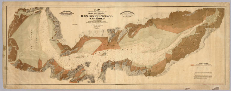
Author
[Arnold, T. J. (Thomas Jefferson), d. 1878, California. Board of State Harbor Commissioners for San Francisco Harbor]
Full Title
Map exhibiting the salt marsh, tide and submerged lands disposed of by the State of California in and adjacent to the bays of San Francisco and San Pablo and now subject to reclamation. Prepared from maps of the U.S. Coast Survey & official records by order of the Board of State Harbor Commissioners for the United States Commissioners on San Francisco Harbor. By T.J. Arnold, engineer of the sea wall. 1874. U.S. Commissioners Rear Admiral John Rodgers, Major G.H. Mendell, Prof. George Davidson. State Harbor Commissioners Samuel Soule, T.D. Mathewson, D.C. McRuer. Britton Rey & Co. Lith. S.F.
List No
4469.000
Note
This map shows the shoreline property sold by the state to private parties and "now subject to reclamation" (i.e. ready to be filled). The Vogdes map is probably later. An unusual view of the bay, with east at the top; shows water depths. With black top and bottom rollers. With full printed color in subtle tan shades. Printed on 2 sheets. David Rumsey copy mounted as one sheet, backed with cloth.
Author
Langley, Henry G.
Full Title
(Advertisement with) Guide Map Of The City Of San Francisco Compiled From The Official Surveys & Engraved Expressly For Langley's San Francisco Directory 1890. Copyright By Geo. B. Wilbur Receiver Of Painter & Co. 1890. McAfee, Baldwin & Hammond. Real Estate Agents And Auctioneers, 10 Montgomery Street, San Francisco. Lots For Sale In All Parts Of The City ...
List No
5315A
Note
Ad for G.G. Wickson & Co. on verso. Map is printed in full color.
Author
Langley, Henry G.
Full Title
Guide Map Of The City Of San Francisco Compiled From The Official Surveys & Engraved Expressly For Langley's San Francisco Directory 1890. Copyright By Geo. B. Wilbur Receiver Of Painter & Co. 1890. McAfee, Baldwin & Hammond. Real Estate Agents And Auctioneers, 10 Montgomery Street, San Francisco. Lots For Sale In All Parts Of The City ...
List No
5315.001
Note
Ad for G.G. Wickson & Co. on verso. Map is printed in full color.
Author
Appleton, D. & Co.
Full Title
Map of San Francisco, California. Copyright 1891 by Matthews-Northrup Co. ... Buffalo, New York. (to accompany) The Library Atlas Of Modern Geography ... New York, D. Appleton And Company 1892. (on upper margin) San Francisco. 56.
List No
0026.144
Note
Color plan of San Francisco. Shows railroads, streets, blocks, parks, etc. Includes numerical references to hotels, major buildings, churches, and places of interest. Relief shown by hachures and spot heights.
Author
Bancroft, A.L.
Full Title
(Covers to) Bancroft's Official Guide Map Of City And County Of San Francisco, Compiled From Official Maps In Surveyor's Office. Published by A.L. Bancroft & Co. ... San Francisco, 1873. Entered ... 1873, by A.L. Bancroft & Company ... Washington, D.C. (inset) Skeleton Map Showing the relative position of San Francisco to the Surrounding Country.
List No
0045A
Author
Bancroft, A.L.
Full Title
Bancroft's Official Guide Map Of City And County Of San Francisco, Compiled From Official Maps In Surveyor's Office. Published by A.L. Bancroft & Co. ... San Francisco, 1873. Entered ... 1873, by A.L. Bancroft & Company ... Washington, D.C. (inset) Skeleton Map Showing the relative position of San Francisco to the Surrounding Country.
List No
0045.001
Note
1st edition 1872. Map is folded into dark brown cloth covers 16x10.5 with "Bancroft's Guide Map Of The City And County Of San Francisco." stamped in gilt.
Author
Edwards, R.M.
Full Title
(Covers to) Railroad Map Of The City Of San Francisco, California. Published by R.M. Edwards, Late D.E. Appleton & Co., Publisher & Bookseller, 508 & 510 Montgomery Street, San Francisco.
List No
0258.001
Note
Dated from the "new mint" at 5th & Mission(1874). Map is folded into maroon cloth covers 12.5x8.5 with beige paste down label "Railroad Pocket Map Of San Francisco."
Author
Edwards, R.M.
Full Title
Railroad Map Of The City Of San Francisco, California. Published by R.M. Edwards, Late D.E. Appleton & Co., Publisher & Bookseller, 508 & 510 Montgomery Street, San Francisco.
List No
0258.002
Note
Dated from the "new mint" at 5th & Mission(1874). Map is folded into maroon cloth covers 12.5x8.5 with beige paste down label "Railroad Pocket Map Of San Francisco."
Author
William P. Humphreys & Co.
Full Title
(Covers to) Atlas of the city and county of San Francisco from actual surveys and official records. Compiled and published by Wm. P. Humphreys & Co., A.B. Holcombe, W.C. Kewen. Eng. by Worley & Bracher ... Phila, Pa. Printed by F. Bourquin ... Phila, Pa. 1876.
List No
0329A
Note
Half leather brown cloth covers with "Atlas of the city & county of San Francisco. W.P. Humphreys & Co." stamped in gilt.
Author
William P. Humphreys & Co.
Full Title
(Title Page to) Atlas of the city and county of San Francisco from actual surveys and official records. Compiled and published by Wm. P. Humphreys & Co., A.B. Holcombe, W.C. Kewen. Eng. by Worley & Bracher ... Phila, Pa. Printed by F. Bourquin ... Phila, Pa. 1876.
List No
0329B
Author
William P. Humphreys & Co.
Full Title
(Contents to) Atlas of the city and county of San Francisco from actual surveys and official records. Compiled and published by Wm. P. Humphreys & Co., A.B. Holcombe, W.C. Kewen. Eng. by Worley & Bracher ... Phila, Pa. Printed by F. Bourquin ... Phila, Pa. 1876.
List No
0329C
Full Title
Map of the city and county of San Francisco. (Compiled and published by Wm. P. Humphreys & Co., A.B. Holcombe, W.C. Kewen. Eng. by Worley & Bracher ... Phila, Pa. Printed by F. Bourquin ... Phila, Pa. 1876.)
List No
0329.001
Note
Hand col. index map. Includes explanation for plat maps.
Full Title
Plat no. 1 (San Francisco. Compiled and published by Wm. P. Humphreys & Co., A.B. Holcombe, W.C. Kewen. Eng. by Worley & Bracher ... Phila, Pa. Printed by F. Bourquin ... Phila, Pa. 1876.)
List No
0329.002
Note
Hand col. map. Relief shown by spot heights. Shows block and lot numbers, wharves, sewers, etc. Covers area east from Kearney and North of Washington. Oriented with north toward lower right. David Rumsey Collection copy has additions by hand.
Full Title
Plat no. 2 (San Francisco. Compiled and published by Wm. P. Humphreys & Co., A.B. Holcombe, W.C. Kewen. Eng. by Worley & Bracher ... Phila, Pa. Printed by F. Bourquin ... Phila, Pa. 1876.)
List No
0329.003
Note
Hand col. map. Relief shown by spot heights. Shows block and lot numbers, sewers, etc. Covers area bounded by Kearney, Washington, Embarcadero, Market and California. Oriented with north toward lower right. David Rumsey Collection copy has additions by hand.
Full Title
Plat no. 3 (San Francisco. Compiled and published by Wm. P. Humphreys & Co., A.B. Holcombe, W.C. Kewen. Eng. by Worley & Bracher ... Phila, Pa. Printed by F. Bourquin ... Phila, Pa. 1876.)
List No
0329.004
Note
Hand col. map. Relief shown by spot heights. Shows block and lot numbers, sewers, etc. Covers area bounded by California, Market and Kearney. Oriented with north toward upper right. David Rumsey Collection copy has additions by hand.
Full Title
Plat no. 4 (San Francisco. Compiled and published by Wm. P. Humphreys & Co., A.B. Holcombe, W.C. Kewen. Eng. by Worley & Bracher ... Phila, Pa. Printed by F. Bourquin ... Phila, Pa. 1876.)
List No
0329.005
Note
Hand col. map. Relief shown by spot heights. Shows block and lot numbers, sewers, etc. Covers area bounded by California, Larkin and the Bay. Oriented with north toward upper right. David Rumsey Collection copy has additions by hand.
Full Title
Plat no. 5 (San Francisco. Compiled and published by Wm. P. Humphreys & Co., A.B. Holcombe, W.C. Kewen. Eng. by Worley & Bracher ... Phila, Pa. Printed by F. Bourquin ... Phila, Pa. 1876.)
List No
0329.006
Note
Hand col. map. Relief shown by spot heights. Shows block and lot numbers, sewers, etc. Covers area bounded by Francisco, Kearney, Vallejo and Larkin including Washington Square. Oriented with north toward upper right. David Rumsey Collection copy has additions by hand.
Full Title
Plat no. 6. Plat no. 7 (San Francisco. Compiled and published by Wm. P. Humphreys & Co., A.B. Holcombe, W.C. Kewen. Eng. by Worley & Bracher ... Phila, Pa. Printed by F. Bourquin ... Phila, Pa. 1876.)
List No
0329.007
Note
Two hand col. maps on 1 sheet. Relief shown by spot heights. Show block and lot numbers, sewers, etc. Cover area bounded by Vallejo, Kearney, Pine and Larkin including Portsmouth Square. David Rumsey Collection copy has additions by hand.
Full Title
Plat no. 8 (San Francisco. Compiled and published by Wm. P. Humphreys & Co., A.B. Holcombe, W.C. Kewen. Eng. by Worley & Bracher ... Phila, Pa. Printed by F. Bourquin ... Phila, Pa. 1876.)
List No
0329.008
Note
Hand col. map. Relief shown by spot heights. Shows block and lot numbers, sewers, etc. Covers area bounded by Pine, Kearney, Market, Ellis and Larkin including Union Square. David Rumsey Collection copy has additions by hand.
Full Title
Plat no. 9 (San Francisco). (with) Plan of pumping district. (Compiled and published by Wm. P. Humphreys & Co., A.B. Holcombe, W.C. Kewen. Eng. by Worley & Bracher ... Phila, Pa. Printed by F. Bourquin ... Phila, Pa. 1876.)
List No
0329.009
Note
Hand col. map. with inset. Relief shown by spot heights. Shows block and lot numbers, sewers, etc. Covers area bounded by Ellis, Market and Larkin including City Hall. Inset map covers area bounded by Greenwich, Embarcadero, Market, Montgomery, Jackson and Sansome, and shows iron flushing pipe, tank and engine house.; scale [ca. 1:4,800] David Rumsey Collection copy has additions by hand.
Full Title
Plat no. 10 (San Francisco. Compiled and published by Wm. P. Humphreys & Co., A.B. Holcombe, W.C. Kewen. Eng. by Worley & Bracher ... Phila, Pa. Printed by F. Bourquin ... Phila, Pa. 1876.)
List No
0329.010
Note
Hand col. map. Relief shown by spot heights. Shows block and lot numbers, sewers, wharves, etc. Covers area bounded by Market , Embarcadero, Harrison and 2nd.
Full Title
Plat no. 11 (San Francisco. (Compiled and published by Wm. P. Humphreys & Co., A.B. Holcombe, W.C. Kewen. Eng. by Worley & Bracher ... Phila, Pa. Printed by F. Bourquin ... Phila, Pa. 1876.)
List No
0329.011
Note
Hand col. map. Relief shown by spot heights. Shows block and lot numbers, sewers, etc. Covers area bounded by Market , 2nd, Harrison and 7th.
Full Title
Plat no. 12 (San Francisco. (Compiled and published by Wm. P. Humphreys & Co., A.B. Holcombe, W.C. Kewen. Eng. by Worley & Bracher ... Phila, Pa. Printed by F. Bourquin ... Phila, Pa. 1876.)
List No
0329.012
Note
Hand col. map. Relief shown by spot heights. Shows block and lot numbers, sewers, wharves, etc. Covers area bounded by Harrison, Steuart, King and 3rd including South Park.
Full Title
Plat no. 13 (San Francisco. (Compiled and published by Wm. P. Humphreys & Co., A.B. Holcombe, W.C. Kewen. Eng. by Worley & Bracher ... Phila, Pa. Printed by F. Bourquin ... Phila, Pa. 1876.)
List No
0329.013
Note
Hand col. map. Relief shown by spot heights. Shows block and lot numbers, sewers, wharves, railroad, etc. Covers area bounded by Harrison, 3rd, Channel St. and 7th.
Full Title
Plat no. 14 (San Francisco. (Compiled and published by Wm. P. Humphreys & Co., A.B. Holcombe, W.C. Kewen. Eng. by Worley & Bracher ... Phila, Pa. Printed by F. Bourquin ... Phila, Pa. 1876.)
List No
0329.014
Note
Hand col. map. Relief shown by spot heights. Shows block and lot numbers, sewers, etc. Covers area bounded by Lewis, Larkin, Chestnut and Steiner including Lobos Square (Moscone Recreation Center) , Alcatraz Square and Fort Mason. David Rumsey Collection copy has additions by hand.
Full Title
Plat no. 15 (San Francisco. (Compiled and published by Wm. P. Humphreys & Co., A.B. Holcombe, W.C. Kewen. Eng. by Worley & Bracher ... Phila, Pa. Printed by F. Bourquin ... Phila, Pa. 1876.)
List No
0329.015
Note
Hand col. map. Relief shown by spot heights. Shows block and lot numbers, sewers, etc. Covers area bounded by Chestnut, Larkin, Broadway and Steiner. David Rumsey Collection copy has additions by hand.
Full Title
Plat no. 16 (San Francisco. (Compiled and published by Wm. P. Humphreys & Co., A.B. Holcombe, W.C. Kewen. Eng. by Worley & Bracher ... Phila, Pa. Printed by F. Bourquin ... Phila, Pa. 1876.)
List No
0329.016
Note
Hand col. map. Relief shown by spot heights. Shows block and lot numbers, sewers, etc. Covers area bounded by Broadway, Larkin, Pine and Steiner including Lafayette Park. David Rumsey Collection copy has additions by hand.
Full Title
Plat no. 17 (San Francisco. (Compiled and published by Wm. P. Humphreys & Co., A.B. Holcombe, W.C. Kewen. Eng. by Worley & Bracher ... Phila, Pa. Printed by F. Bourquin ... Phila, Pa. 1876.)
List No
0329.017
Note
Hand col. map. Relief shown by spot heights. Shows block and lot numbers, sewers, etc. Covers area bounded by Pine, Larkin, Eddy and Steiner. David Rumsey Collection copy has additions by hand.
Full Title
Plat no. 18 (San Francisco. (Compiled and published by Wm. P. Humphreys & Co., A.B. Holcombe, W.C. Kewen. Eng. by Worley & Bracher ... Phila, Pa. Printed by F. Bourquin ... Phila, Pa. 1876.)
List No
0329.018
Note
Hand col. map. Relief shown by spot heights. Shows block and lot numbers, sewers, etc. Covers area bounded by Eddy, Larkin, Fell and Steiner, including Jefferson Square. David Rumsey Collection copy has additions by hand.
Full Title
Plat no. 19 (San Francisco. (Compiled and published by Wm. P. Humphreys & Co., A.B. Holcombe, W.C. Kewen. Eng. by Worley & Bracher ... Phila, Pa. Printed by F. Bourquin ... Phila, Pa. 1876.)
List No
0329.019
Note
Hand col. map. Relief shown by spot heights. Shows block and lot numbers, sewers, etc. Covers area bounded by Fell, Market, Ridley and Steiner, including Protestant Orphan Asylum. David Rumsey Collection copy has additions by hand.
Full Title
Plat no. 20 (San Francisco. (Compiled and published by Wm. P. Humphreys & Co., A.B. Holcombe, W.C. Kewen. Eng. by Worley & Bracher ... Phila, Pa. Printed by F. Bourquin ... Phila, Pa. 1876.)
List No
0329.020
Note
Hand col. map. Relief shown by spot heights. Shows block and lot numbers, sewers, shoreline, etc. Covers area bounded by the Bay, Steiner, Chestnut and Charter line of 1857 (Divisadero). David Rumsey Collection copy has additions by hand.
Full Title
Plat no. 21 (San Francisco. (Compiled and published by Wm. P. Humphreys & Co., A.B. Holcombe, W.C. Kewen. Eng. by Worley & Bracher ... Phila, Pa. Printed by F. Bourquin ... Phila, Pa. 1876.)
List No
0329.021
Note
Hand col. map. Relief shown by spot heights. Shows block and lot numbers, sewers, etc. Covers area bounded by Chestnut, Steiner, Broadway and Charter line of 1857 (Divisadero). David Rumsey Collection copy has additions by hand.
Full Title
Plat no. 22 (San Francisco. (Compiled and published by Wm. P. Humphreys & Co., A.B. Holcombe, W.C. Kewen. Eng. by Worley & Bracher ... Phila, Pa. Printed by F. Bourquin ... Phila, Pa. 1876.)
List No
0329.022
Note
Hand col. map. Relief shown by spot heights. Shows block and lot numbers, sewers, etc. Covers area bounded by Broadway, Steiner, Pine and Charter line of 1857 (Divisadero), including Alta Plaza. David Rumsey Collection copy has additions by hand.
Full Title
Plat no. 23 (San Francisco. (Compiled and published by Wm. P. Humphreys & Co., A.B. Holcombe, W.C. Kewen. Eng. by Worley & Bracher ... Phila, Pa. Printed by F. Bourquin ... Phila, Pa. 1876.)
List No
0329.023
Note
Hand col. map. Relief shown by spot heights. Shows block and lot numbers, sewers, etc. Covers area bounded by Pine, Steiner, Eddy and Charter line of 1857 (Divisadero), including Hamilton Square. David Rumsey Collection copy has additions by hand.
Full Title
Plat no. 24 (San Francisco. (Compiled and published by Wm. P. Humphreys & Co., A.B. Holcombe, W.C. Kewen. Eng. by Worley & Bracher ... Phila, Pa. Printed by F. Bourquin ... Phila, Pa. 1876.)
List No
0329.024
Note
Hand col. map. Relief shown by spot heights. Shows block and lot numbers, sewers, etc. Covers area bounded by Eddy, Steiner, Fell and Charter line of 1857 (Divisadero), including Alamo Square. David Rumsey Collection copy has additions by hand.
|