|
Author
Wit, Frederick de (1629-1706)
Full Title
Littora Brasiliae. Apud F. de Wit. | Pascaert van Brasil. Gedruckt by F. de Wit.
List No
15889.035
Author
Rand McNally and Company
Full Title
The Rand McNally New Library Atlas Map of Brazil and Guiana.
List No
15825.002
Author
Pan American World Airways
Full Title
(PAA Route Map.) Port of Spain (to) Belem.
List No
12365.005
Note
Date estimated.
Author
Blaeu, Joan, 1596-1673
Full Title
Brasilia
List No
15664.126
Note
60 Duytsche mylen 15 op een graedt = 4.2 cm [et al.]
Author
Blaeu, Joan, 1596-1673
Full Title
Sinvs Omnivm Sanctorvm
List No
15664.141
Note
Mensura duroum miliarium Germanicorum Mate van twee Duÿtsche Mÿlen = 7.6 cm
Author
Blaeu, Joan, 1596-1673
Full Title
Praefectra De Cirîiî
List No
15664.143
Note
5 Milliaria horaria quorum novemdecim uni gradui latitud. respondent = 6.8 cm
Author
Blaeu, Joan, 1596-1673
Full Title
Praefecturae Paranambucae Pars Borealis
List No
15664.145
Note
4 Milliaria Germanica 15. uni gradui respondentia = 6.8 cm [et al.]
Author
Blaeu, Joan, 1596-1673
Full Title
Praefecturae Paranambucae Pars Meridionalis
List No
15664.147
Note
5 Milliaria horaria quorum novemdecim uni gradui latitud. respondent = 6.8 cm
Author
Blaeu, Joan, 1596-1673
Full Title
Praefectura De Paraiba, Et Rio Grande
List No
15664.149
Note
8 Milliaria horaria quorum novemdecim uni gradui latitud. respondent = 10.8 cm
Author
Monte (Monti), Urbano, 1544-1613
Full Title
Tavola XXIIII. Che Ha Sua Superiore La Tavola. XII. Libro Terzo.
List No
10130.026
Author
Nakajima, Kazuo 中島和夫
Full Title
新案聖州地圖. [New Map of the Holy Land].
List No
15100.002
Note
Date estimated.
Author
Rodriguez, Eugenio
Full Title
(Composite map to) No. 1-4 Carte generale delle coste del Brasile Del Rio del Plata al Para ... No. 4. Anno 1857. Lit. Richter e C. Napoli. (to accompany) Atlante Della Guida Generale Per La Navigazione Delle Coste Settentrionali Ed Orientali dell'America del Sud ... per Eugenio Rodriguez ..., Napoli 1857.
List No
13048.039
Note
Folded nautical charts of the coasts of Brazil, from River Plate to Para. Relief shown by hachures. Depth shown by isolines and soundings. Includes legend and explanation.
Author
Rodriguez, Eugenio
Full Title
Pianta dell' entrata della Baia di Rio Janeiro : su quella levata dal Sigr. Jehenne. (to accompany) Atlante Della Guida Generale Per La Navigazione Delle Coste Settentrionali Ed Orientali dell'America del Sud ... per Eugenio Rodriguez ..., Napoli 1857. (inset view) Vesuta dell entrada della baia di Rio Janeiro ...
List No
13048.014
Note
Folded nautical chart of the Bay of Rio de Janeiro. Scala di 4 miglia marittime (= 11.9 cm). Relief shown by hachures. Depth shown by isolines and soundings. Includes legend and explanation.
Author
Rodriguez, Eugenio
Full Title
Entrata della baia di Rio Janeiro. (to accompany) Atlante Della Guida Generale Per La Navigazione Delle Coste Settentrionali Ed Orientali dell'America del Sud ... per Eugenio Rodriguez ..., Napoli 1857.
List No
13048.015
Note
View of the entrance to the Bay of Rio Janeiro.
Author
Rodriguez, Eugenio
Full Title
Pianta della Baia di Rio - Janeiro : su quella levata dal Sigr. Barral ... Publicata nel 1843 Deposito Generale delle Carte della Marina Imperiale Francese. (to accompany) Atlante Della Guida Generale Per La Navigazione Delle Coste Settentrionali Ed Orientali dell'America del Sud ... per Eugenio Rodriguez ..., Napoli 1857.
List No
13048.016
Note
Folded nautical chart of the Bay of Rio de Janeiro. Scala di otto miglia marittime (= 23.9 cm). Relief shown by hachures. Depth shown by isolines and soundings. Includes legend and explanation.
Author
[Silk, D. Wenaslin, Cavalcanti, Manoel Paulino, Sociedade Nacional de Agricultura (Brazil). Seccao de Geographia Agricola]
Full Title
Sociedade Nacional de Agricultura. Seccao Geographia Agricola : Grande premio na Expisicao Nacional de 1908. (Gradn prix a l'Exposicao Nacional 1908). Ensaio de mappa geologico do Brazil (Etude de carte geologique du Bresil). Visto, D. Wenaslin Silk. Organisado por M. Paulino Cavalcanti. Seccao Cartographica do Estabelecimento Graphico - Weiszflog, Irmaos - S. Paulo. (to accompany: Atlas do Brazil).
List No
11947.003
Note
Geological map of Brazil. Shows administrative divisions, rivers, forests and mountains. Relief shown by hachures. Includes legend.
Author
[Silk, D. Wenaslin, Cavalcanti, Manoel Paulino, Sociedade Nacional de Agricultura (Brazil). Seccao de Geographia Agricola]
Full Title
Sociedade Nacional de Agricultura. Seccao Geographia Agricola : Grande premio na Expisicao Nacional de 1908. (Gradn prix a l'Exposicao Nacional 1908). Ensaio de mappa agrologico do Brazil (Etude de carte agrologique du Bresil). Visto, D. Wenaslin Silk. Organisado por M. Paulino Cavalcanti. Seccao Cartographica do Estabelecimento Graphico - Weiszflog, Irmaos - S. Paulo. (to accompany: Atlas do Brazil).
List No
11947.004
Note
Agrological map of Brazil. Shows types of soil, administrative divisions, major cities, rivers, etc. Relief shown by hachures. Includes legend.
Author
[Silk, D. Wenaslin, Cavalcanti, Manoel Paulino, Sociedade Nacional de Agricultura (Brazil). Seccao de Geographia Agricola]
Full Title
Sociedade Nacional de Agricultura. Seccao Geographia Agricola : Grande premio na Expisicao Nacional de 1908. (Gradn prix a l'Exposicao Nacional 1908). Mappa demographico do Brazil (Carte demographique du Bresil). Visto, D. Wenaslin Silk. Organisado por M. Paulino Cavalcanti. Seccao Cartographica do Estabelecimento Graphico - Weiszflog, Irmaos - S. Paulo. (to accompany: Atlas do Brazil). (inset) America d Sul. Diagramma da populacao absouluta.
List No
11947.007
Note
Demographic map of Brazil, with diagram of the population of South America. Shows administrative divisions, major cities, rivers, forests and mountains. Relief shown by hachures. Includes legend.
Author
Mendes, Candido, 1818-1881
Full Title
II. Imperio do Brazil. Quadro Estatistico. (To accompany) Atlas do imperio do Brazil ... Organisado por Candido Mendes de Almeida. Rio de Janeiro : Lithographia do Instituto Philomathico. 1868. (inset) Mappa do Oceano Atlântico com indicacao aproximada dos roteiros das viagens dos descobridores do Brasil ... 1499 e 1500.
List No
11946.022
Note
Engraved color map of Brazil Empire. Inset represents the routes of the voyagers of Brazil, with dates and name of early explorers. Map shows administrative divisions by color, capitals, provinces, cities, population, etc. Relief shown by hachures. Depth shows by isolines. Includes statistical table.
Author
Mendes, Candido, 1818-1881
Full Title
II A. Imperio do Brazil. (To accompany) Atlas do imperio do Brazil ... Organisado por Candido Mendes de Almeida. Rio de Janeiro : Lithographia do Instituto Philomathico. 1868. (insets) Ilhas e lagos notaveis do Brazil.
List No
11946.023
Note
Engraved color map of Brazil Empire. Insets represent Brazil's islands and lakes. Map shows administrative division by color, capitals, provinces, cities, population, etc. Relief shown by hachures. Depth shows by isolines. Includes statistical table on the Brazilian Catholic Church.
Author
Mendes, Candido, 1818-1881
Full Title
II B. Imperio do Brazil. Divisao Electoral. (To accompany) Atlas do imperio do Brazil ... Organisado por Candido Mendes de Almeida. Rio de Janeiro : Lithographia do Instituto Philomathico. 1868. (insets) Rios do Brazil : notaveis pelo seu curso calculado em kilometros.
List No
11946.024
Note
Engraved color map of Brazil Empire. Inset views represent the length of the rivers and comparative heights of the mountains of Brazil. Map shows administrative divisions by color, capital, cities, villages, population and parishes. Relief shown by hachures. Depth shows by isolines. Includes statistical table on the electoral division of the Empire.
Author
[Mezoly, Tomas, Rabong, Joao]
Full Title
3. Ruas Principais Da Parte Sul Da Cidade Do Rio De Janeiro. Tomas Mezoly & Joao Rabong.
List No
11629.004
Note
Color pictorial map the coastal areas of city of Rio De Janeiro, Brazil on 5 sheets, with an index map. Shows the area along the coast, the streets, buildings, landmarks, airport, parks and points of interest. The individual maps capture the charm of the time along with these specific regions. Date estimated.
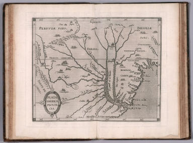
Author
[Wytfliet, Corneille, Magini, Giovanni Antonio]
Full Title
Plata Americae provincia. (to accompany) Histoire universelle des Indes occidentales et orientales, et de la conversion des Indiens : divisee en trois parties par Cornille Wytfliet & Anthoine Magin & autres historiens. Premiere Partie. A Douay, Chez Francois Fabri, l'An 1611.
List No
11622.020
Note
Uncolored engraved double page map of the Rio de la Plata region. Covers Argentina, Uruguay and the southern part of Brazil. Shows cities, towns, landmarks, rivers, capes, bays and mountains. Relief shown pictorially. Includes decorative title cartouche.
Author
[Eschwege, Wilhelm Ludwig von, Martius, Karl Friedrich Philipp von]
Full Title
(Composite map of) Karte von Ost-Brasilien. Carte geographique de la partie orientale de l'empire du Bresil, en quatre Feuilles : contenant les provinces maritimes de Pernambuco jusqua Rio de Janeiro, celle de Minas Geraes, et une partie des provinces limitrophes, redigee d'apres leures propres observations et les cartes les plus exactes, et dediee A S.M. Don Pedro Empereur du Breso; par Guill de Eschwege et Ch. F. Ph. de Martius; dressee par I. Schwarzmann. Munich 1831. (insets) Les environs de Villa Rica. (with) Les environs de Rio de Janeiro. (with) Bahia do Rio de Janeiro.
List No
11292.005
Note
Composite of the sheets (1 - 4) of the map of eastern Brazil. Title on sheet 1. Relief shown by shading and spot heights. Shows rivers, cities and towns. Includes abbreviations and explanations of symbols. Title in French and German. Insets on sheet 4.
Author
Arrowsmith, John
Full Title
Brazil, by J. Arrowsmith. London, pubd. Feby. 15, 1832 by J. Arrowsmith, 35 Essex Street, Strand.
List No
0036.049
Note
Engraved map. Hand colored boundaries. Relief shown by hachures. Shows political divisions, roads, Indian tribes, etc. Includes the Guianas, Paraguay and Uruguay.
Author
Brue, Adrien Hubert, 1786-1832
Full Title
Carte du Bresil et d'une partie des pays adjacents. Redigee par A. Brue, Geographe du Roi. Paris, 1826. Chez l'Auteur, rue des Macons-Sorbonne, no. 9, et chez les principaux m(archan)ds de cartes geographiques.
List No
0096.066
Note
Hand colored engraved map. Relief shown by hachures. Prime meridian: Paris. Extension of map at left pasted on. Covers also Paraguay and Uruguay.
Full Title
Carte geographique, statistique et historique du Bresil. Bresil. Grave par Beaupre, Rue de Vaugirard, No. 81, a Paris. Fonderie et Imprimerie de J. Carez. (1825)
List No
0102.054
Note
Hand colored engraved map. Relief shown by hachures. Text and tables at sides and bottom. Prime meridians: Washington and Paris.
Author
[Carey, H. C., Lea, I.]
Full Title
Geographical, Historical, And Statistical Map Of Brazil. Brazil. No. 48. Drawn by J. Finlayson. Engraved by Young & Delleker.
List No
0122.043
Note
In full color by region surrounded by text.
Author
Colton, G.W.
Full Title
Brazil And Guayana (with) two inset maps: Pernambuco and Rio de Janeiro. Published By J.H. Colton & Co. No. 172 William St. New York. Entered ... 1855 by J.H. Colton & Co. ... New York. No. 61.
List No
0149.066
Note
In full color by region.
Author
Colton, G.W.
Full Title
Colton's Brazil and Guayana. (inset) Rio de Janeiro and Pernambuco. Published By J. H. Colton. No. 172 William St. New York.
List No
0151.070
Note
Prime meridians are Greenwich and Washington D.C. Relief shown by hachures.
Author
Colton, G.W.
Full Title
Colton's Brazil and Guayana. (inset) Pernambuco and Rio de Janeiro. Published By G. W & C. B. Colton & Co. No. 172 William St. New York.
List No
0152.072
Note
Prime meridians are Washington D.C. and Greenwich.
Author
[Dower, John, Higgins, W.M.]
Full Title
Brazil.
List No
0247.130
Author
[Bowen, Emanuel, Gibson, John]
Full Title
Brasil. (to accompany) Atlas Minimus or a New Set of Pocket Maps of the Several Empires, Kingdoms and States of the Known World, with Historical Extracts relative to each. Drawn and Engraved by J. Gibson from the Best Authorities, Revis'd, Corrected and Improv'd by Eman: Bowen Geographer to His Majesty.
List No
0300.054
Note
First edition. The "Historical Extracts" are short bits of text printed on the maps giving relevant geographical information. A revised edition was published in London in 1792. In 1759, another edition was published adding separate geographical descriptions and correcting some of the maps (see our copy). The Philadelphia 1798 edition by Mathew Carey incorporates the 1759 edition text word for word (excepting the maps of United States which Carey omits in favor of his pocket atlas of the U.S.). Gibson and Bowen made the four sheet map of North America (Stevens 49), and Gibson made the four sheet map of America (Stevens 3).
Full Title
Brazil, Bolivia & Peru. J.H. Young Sc. (Philadelphia: John Grigg, No. 9 North Fourth Street. 1830)
List No
0315.014
Note
Engraved map. Full hand color. Relief shown pictorially. Prime meridians: Greenwich and Washington.
Author
Johnston, Alexander Keith
Full Title
South America (northern sheet). (with) Galapagos Isles. By Keith Johnston, F.R.S.E. Keith Johnston's General Atlas. Engraved, Printed, and Published by W. & A.K. Johnston, Edinburgh & London.
List No
0377.054
Note
Countries and provinces outlined in color. Relief shown by hachures. Five scales. One inset.
Author
Johnston, Alexander Keith
Full Title
South America (southern sheet). By Keith Johnston, F.R.S.E. Keith Johnston's General Atlas. Engraved, Printed, and Published by W. & A.K. Johnston, Edinburgh & London.
List No
0377.055
Note
Countries and provinces outlined in color. Relief shown by hachures. Five scales.
Author
La Perouse, Jean-Francois de Galaup, comte de, 1741-1788
Full Title
View of the Island of St. Catherine. de Vancy delt. Published as the Act directs Novr. 1st 1798, by G.G. & J. Robinson, Pater-noster Row. de Vancy, delt. Heath Sculpt. No. 2.
List No
0414.002
Note
Engraved. Shows landscape, buildings, and manner of dress.
Author
Lizars, Daniel
Full Title
Lower Peru, Brazil & Paraguay. Published by D. Lizars, Edinburgh. (1831?)
List No
0436.064
Note
Hand colored engraved map. Relief shown by hachures. Shows settlements, rivers, etc.
Author
Lizars, William Home, 1788-1859
Full Title
Lower Peru, Brazil & Paraguay. Published by W. Lizars, Edinburgh. (to accompany) Lizars' Edinburgh Geographical General Atlas ... 1841.
List No
0438.079
Note
Double page engraved hand colored in outline. Shows political boundaries, cities, Indian settlements, rivers and mountains. Relief shown by hachures. Prime meridian is Greenwich.
Author
Malte-Brun, Conrad, 1775-1826
Full Title
Carte de Bresil, 1836. No. 65. Grave par Thierry.
List No
0458.067
Note
Engraved map. Countries and states trimmed in color. Rivers, lakes, islands, and peoples shown. Major relief shown by hachures. Includes 4 scales.
Author
Martin de Moussy, V. (Victor), 1810-1869
Full Title
Carte du cours du Haut Uruguay depuis la Concepcion jusqu'aux frontieres Argentine et Bresilienne dans le Territoire extreme des Missions. 2eme. feuille. De la Ville de la Uruguayana au Rio Pepiri-Guazu. Par le Dr. V. Martin de Moussy, 1866. Grave par Kautz, r. Bonaparte 82 - Paris. Paris - Imp. Lemercier, r. de Seine 57. (Paris Librairie de Firmin Didot Freres, Fils et Cie., 1873)
List No
0464.027
Note
Lithographed map in 5 segments (IV-VIII). Relief shown by hachures. "Description geographique et statistique de la Confederation Argentine. Atlas. Planche XXVIII."
Author
[Martin, R.M., Tallis, J. & F.]
Full Title
Brazil. The Illustrations by H. Winkles & Engraved by W. Lacey. The Map Drawn & Engraved by J. Rapkin.
List No
0466.079
Note
Region in outline color surrounded by drawings of boats on the Rio Negro, Cape St. Antonio and three city views: St. Catharina, Monte Video and Rio de Janeiro.
Author
Mitchell, Samuel Augustus
Full Title
Brazil. (with) two inset maps: Paraguay and Environs of Rio Janeiro.
List No
0537.041
Note
In full color.
Author
Mitchell, Samuel Augustus
Full Title
Brazil. (2 inset maps) Paraguay and Environs of Rio Janeiro.
List No
0545.045
Note
Full and outline color map. Includes explanation chart, showing capitals, important towns, etc. Prime meridian is Washington, D.C. Relief shown by hachures.
Author
Mitchell, Samuel Augustus
Full Title
Map Of Brazil, Bolivia, Paraguay, And Uruguay. 50. (with) two inset maps: Harbor Of Rio Janeiro. 51. Harbor of Bahia. 52. (and) Map of Chili. 53. (with) inset map Island Of Juan Fernandez. 54. Entered ... 1860, by S. Augustus Mitchell, Jr. ... Pennsylvania.
List No
0565.031
Note
In full color by region.
Author
Mitchell, Samuel Augustus Jr.
Full Title
Map of Brazil, Bolivia, Paraguay, and Uruguay. (with four insets) 59. Harbor of Rio Janeiro. 60. Harbor of Bahia. 61. Map of Chile. 62. Island of Juan Fernadez. Entered ... 1860 by S. Augustus Mitchell, Jr. ... Pennsylvania.
List No
0572.044
Note
Full color map by country. Relief shown by hachures. Prime meridians are Greenwich and Washington, D.C.
Author
Mitchell, Samuel Augustus Jr.
Full Title
Map of Brazil, Bolivia, Paraguay, and Uruguay. (inset maps) 65. Harbor of Rio Janeiro. 66. Harbor of Bahia. 67. Map of Chili. 68. Island of Juan Fernandez. Entered ... 1867 by S. Augustus Mitchell, Jr. ... Pennsylvania.
List No
0579.049
Note
Color map. Relief shown by hachures. Prime meridians are Greenwich and Washington, D.C.
Author
Mitchell, Samuel Augustus
Full Title
Map of Brazil, Bolivia, Paraguay, and Uruguay. (with) Map of Chili. (with) Harbor of Bahia. (with) Harbor of Rio Janeiro. (with) Island of Juan Fernandez. Entered ... 1879 by S. Augustus Mitchell ... Washington. (1880)
List No
0586.056
Note
Hand colored map with 4 insets. Relief shown by hachures. Shows states and departments, settlements, railroads, etc. Prime meridians: Greenwich and Washington.
Author
Mitchell, Samuel Augustus Jr.
Full Title
Map of Brazil, Bolivia, Paraguay, and Uruguay. (with) Map of Chili. (with) Harbor of Bahia. (with) Harbor of Rio Janeiro. (with) Island of Juan Fernandez. Copyright 1886 by Wm. M. Bradley & Bro.
List No
0592.057
Note
Hand colored map with 4 insets. Relief shown by hachures. Shows states and departments, settlements, railroads, etc. Prime meridians: Greenwich and Washington.
Full Title
Map of Brazil, Bolivia, Paraguay, and Uruguay. (with) Map of Chili. (with) Harbor of Bahia. (with) Harbor of Rio Janeiro. (with) Island of Juan Fernandez. Copyright 1887 by Wm. M. Bradley & Bro. (1890)
List No
0594.055
Note
Hand colored map with 4 insets. Relief shown by hachures. Shows states and departments, settlements, railroads, etc. Prime meridians: Greenwich and Washington.
|


![新案聖州地圖. [New Map of the Holy Land].](https://www.davidrumsey.com/rumsey/Size2/RUMSEY~8~1/199/15100002.jpg)