|
REFINE
Browse All : Images of Birmingham (Ala.)
1-8 of 8
Author
[Ford Motor Company, United States. Army. Air Corps]
Full Title
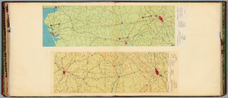
Air navigation map no. 49 (experimental) : Nashville, Tenn. to Birmingham, Ala. Compiled and reproduced by the Engineer Reproduction Plant, Corps of Engineers. Under the direction of the Airways Section, Office Chief of Air Corps. 1927. Engineer Reproduction Plant, U.S. Army, Washington Barracks, D.C. 6276. -- Air navigation map no. 50 (experimental) : Birmingham, Ala. to Pensacola, Fla. Compiled and reproduced by the Engineer Reproduction Plant, Corps of Engineers. Under the direction of the Airways Section, Office Chief of Air Corps. 1927. R-1928. Engineer Reproduction Plant, U.S. Army, Washington Barracks, D.C. 6277.
List No
14501.028
Note
Two aeronautical charts representing the areas from Nashville, Tennessee, to Birmingham, Alabama, and from Birmingham to Pensacola, Florida. Features military, municipal, commercial, emergency, and seaplane landing fields. Also shows political boundaries, roads, railways, cities, towns, topography, bodies of water, drainage, and coastlines. Relief shown with contour lines and color coding. Maps include latitudinal and longitudinal lines, legend, scale statements, and bar scales given in miles, as well as compass roses oriented toward left and right of sheet, respectively. Color lithographs. Together, maps are 56 x 92 cm, on double sheet, 60 x 135 cm.
Author
[Ford Motor Company, U.S. Coast and Geodetic Survey]
Full Title
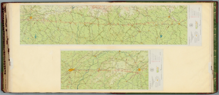
Airway map no. 127 : Birmingham Ala. to Atlanta Ga. Compiled and printed for the Aeronautics Branch of the Department of Commerce by the Coast and Geodetic Survey, Washington, D.C. 1929. -- Airway map no. 128 : Atlanta Ga. to Greensboro N.C. Compiled and printed for the Aeronautics Branch of the Department of Commerce by the Coast and Geodetic Survey, Washington, D.C. 1929.
List No
14501.038
Note
Two aeronautical charts representing the areas from Birmingham, Alabama, to Atlanta, Georgia, and from Atlanta to Greensboro, North Carolina. Features military, municipal, and commercial landing fields, seaplane anchorage and beacons. Also shows political boundaries, roads, railways, cities, towns, topography, bodies of water, and drainage. Relief shown with contour lines and color coding. Maps include latitudinal and longitudinal lines, legend, scale statements, and bar scales given in miles, as well as compass roses oriented toward top of sheet (with slight variation between the two maps). With the seal of the Department of Commerce, United States of America. Color lithographs. Together, maps are 56 x 120 cm, on double sheet, 60 x 135 cm.
Author
Nichols, Bobbie
Full Title
Flying over Howard College A.D. 1943. By Bobbie Nichols.
List No
11352.000
Note
Uncolored pictorial map showing view of Howard physical and cultural campus. Covers various buildings and facilities.
Author
[Nirenstein, Nathan, Funk & Wagnalls Company.]
Full Title
(One Hundred Per Cent Business Real Estate Locations), Birmingham, (Alabama).
List No
12508.012
Author
Rand McNalley & Company
Full Title
Atlanta, Ga. -- Albanay, N.Y. -- Atlantic City, N. J. -- Baltimore, Md. -- Birmingham, Ala. -- Boston, Mass., and vicinity -- Buffalo, N.Y., and vicinity.
List No
14003.054
Note
7 road maps of cities. Maps include compass roses and legends. Copyright by Rand McNally & Company, Chicago, Ill. Lithographed in the U.S.A.
Author
Cram, George Franklin, 1841-1928
Full Title
Birmingham.
List No
14372.301
Note
Map of Birmingham, Alabama. Shows political boundaries, railroads, streets, bridges, parks, topography, bodies of water and drainage. Relief shown with hachures. Colored lithograph. Map is 26 x 32 cm, on sheet 33 x 45 cm.
Author
Cram, George Franklin
Full Title
Birmingham.
List No
2809.120
Note
Relief shown by hachures.
Author
Archar Inc.
Full Title
Birmingham. City Character Print. Produced and Published by Archar Inc. P.O. Box 999 Station U. Toronto, Canada. M8Z 5p9. Copyright 1981. Printed in Canada. .
List No
8412.000
Note
Pictorial map with birds-eye view. City Character Print series. Depicting businesses and buildings, and points of interest around Bringham Alabama in that time. Map filled with descriptive notes, figures, and recreational activities. At bottom center : "M.E.G., "G.M.L."and some figures representing the city.
1-8 of 8
|