|
REFINE
Browse All : Images of Barbary Coast
1-10 of 10
Author
Collin, Edouard
Full Title
Carte des côtes de Barbarie, comprenant les états de Maroc, Fez, Alger, Tunis et Tripoli Enrichie des Plans des principales Places et ports
List No
15514.002
Author
Cassini, Gio. Ma. (Giovanni Maria), 1745-approximately 1824
Full Title
(14) Le coste di Barbaria ovvero i Regni di Marocco, di Fez, di Algeri, di Tunsi, e di Tripoli coi paesi circonvicini delineati sulle ultime osservazioni. Roma, presso la Calcografia Camerale, 1789.
List No
14000.185
Note
Relief shown pictorially. Includes decorative title cartouche and bar scale. In Volume III.
Author
Duval, Henri (Henri Louis Nicolas), 1783-1854
Full Title
Ier Tableau synchronique de l'histoire moderne : Barbares. Par Henri Duval, Chevalier de la Légion-d'Honneur; Professeur d'Histoire, de Géographie, de Belles-Lettres, etc., etc. Gravé par Laguillermie rue des Noyers No. 56. Delloye, Libraire, Place de la Bourse, No 13. Tous les Exemplaires ont le Timbre de l'Auteur. Imprimerie de Terzuolo, Successeur de M. Plassan, Rue de Vaugirard, No 11.
List No
14254.014
Note
Engraved, hand-colored map of Europe, the Middle East and North Africa, showing political boundaries, cities, topography, coastlines and routes of travel, including along the Barbary Coast. Title translates to: First synchronic table of modern history : Barbarians. Includes latitudinal and longitudinal lines. Accompanied by descriptive text in tables within margins. Tables are color-coded in association with each route shown, such as green for the Huns. With addresses in top corners: L'Auteur, Rue des Martyrs, no 23, Chaussée-d'Antin -- Adopté pour les maisons Royles d'Éducation de la Légion-d'Honneur. Map is 16 x 21 cm, on sheet 42 x 61 cm. In second section: Histoire et géographie modernes [= Modern history and geography].
Author
Borghi, Bartolomeo, 1750-1821
Full Title
Le Coste di Barberia parte Occidentale, dell'A. B. Borghi. Firenze 1818. -- Le Coste di Barberia parte Orientale.
List No
14255.148
Note
Two engraved historical and political maps - western and eastern parts - of the Barbary Coast of Northern Africa, with hand-colored outlines delineating boundaries. Titles translate to: [The Coast of Barbary, western part] -- [The Coast of Barbary, eastern part]. Maps show political boundaries, topography, drainage, coastlines, islands and routes of travel. Relief shown pictorially. With latitudinal and longitudinal lines, as well as a bar scale on second map. Imprint beneath title of first map. Together, maps are 30 x 22 cm, on sheet 47 x 35 cm. Descriptive text appears on prior plate (142).
Author
[Morden, Robert, approximately 1650-1703, Cockerill, Thomas, active 1674-1702]
Full Title
(Text Page to) Of Barbary (1).
List No
14323.154
Note
Two maps of the Barbary Coast, Africa. Maps include title cartouches: West Barbarie, by Robt Morden -- East Barbarie, by Robt. Morden. Maps show political boundaries, cities, topography, drainage, coastlines and islands. Relief shown pictorially. Each map contains latitudinal and longitudinal lines. Together, maps are 11 x 13 cm, on sheet 15 x 20 cm. Accompanied by descriptive text. Text spans pages 322-328.
Author
[Pawley, Neele, Samuel John, 1758-1824, Neele, George, Pinnock and Maunder]
Full Title
Barbary & c. Neele sculp. Published Jany. 1st. 1819, by Pinnock & Maunder Strand.
List No
14326.036
Note
Map of the Barbary Coast and vicinity. Shows political boundaries, cities, railroads, routes, topography, deserts, major lakes and drainage, coastlines and islands. Relief shown with hachures. Includes latitudinal and longitudinal lines, as well as a compass rose and bar scale, given in British miles. Descriptive text throughout. Hand-colored engraving, including illustration of clouds behind title. Map is 21 x 27 cm, on sheet 26 x 34 cm.
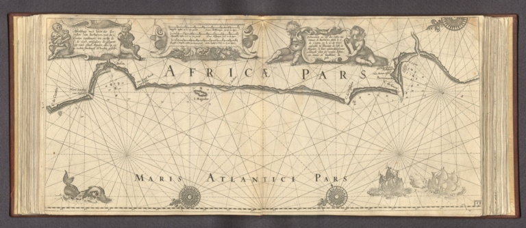
Author
Blaeu, Willem Janszoon, 1571-1638
Full Title
Eijgentlijke vertooninge der westcustē van Barbarien, tusschen de Strate van Gibraltar ende de C. de Cantin, zampt aller Reeden Havenen ende Rivieren aldaer gelegen, en hoemen die bequa melijck sal beseijlen. = Vraije pourtraicture des costes occidentales de Barbarie, entre l'estroict de Gibraltar et le C. de Cantin, ensemble de toutes Rades, Haures, Ports et Rivieres situez ausdic tes costes, et commet commodieusement on les navigera.
List No
14351.100
Note
Nautical chart showing the Barbary Coast. Parallel titles appears in Dutch and French, translating (loosely) to: True portrait of the western coasts of Barbary, between the Strait of Gibraltar and the Cape of Cantin ... Features cities, roads, ports, topography, coastlines, shoals, islands, anchorage, soundings and ships. Relief shown pictorially. Includes three bar scales, latitudinal and longitudinal lines, rhumb lines and compass roses, with north oriented toward lower left. Decorative cartouches. Black and white engraving. Chart is 25 x 55 cm, on double sheet 26 x 58 cm. Appears in "Eerste boeck" of atlas.
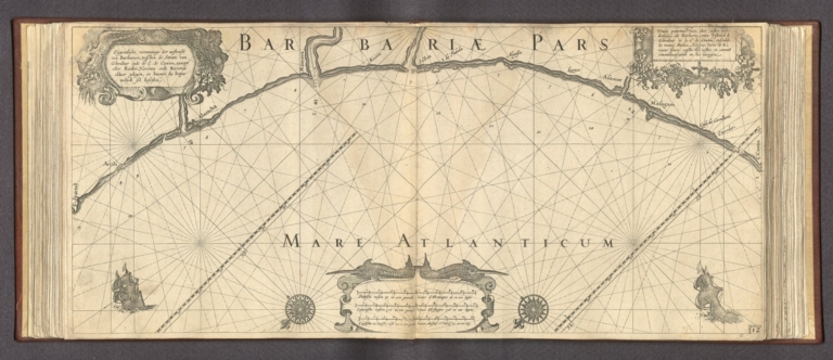
Author
Blaeu, Willem Janszoon, 1571-1638
Full Title
Afbeeldinge nae't leven der Zeecusten van Barbarien. van de C. Cantin zuijdwaert tot verbij de C. de Geer, mitsgaders de gelegent: heijt van't eijlant Mogodor, alles op zijne rechte streckingē en hoochte gesteli. = Delineation au vif des costes maritimes de Barbarie, entre le C. de Cantin et le C. de Geer, ensemble la situation de l'isle de Mogodor, le tout commodieusement accōmodé selon ses vraijes distances, routes et haulteurs du pole.
List No
14351.101
Note
Nautical chart showing the Barbary Coast. Parallel titles appears in Dutch and French, translating (loosely) to: Depiction of the heart of the Barbary coast, between Cape of Cantin to the Cape of Geer ... Features cities, roads, ports, topography, coastlines, shoals, islands, anchorage, soundings and ships. Relief shown pictorially. Includes three bar scales, latitudinal and longitudinal lines, rhumb lines and compass roses, with north oriented toward lower left. Decorative cartouches. Black and white engraving. Chart is 25 x 55 cm, on double sheet 26 x 58 cm. Appears in "Eerste boeck" of atlas.
Author
[Faden, William, 1749-1836, Delarochette, L. (Louis), 1731-1802]
Full Title
A chart of the coasts of Spain and Portugal, with the Balearic Islands, and part of the coast of Barbary. By L. S. de la Rochette. MDCCLXXX. 2nd. Edition. London : engraved & published as the Act directs, by Wm. Faden, successr. to the late T. Jeffreys, Geogr. to the King, Charing Cross, June 28th, 1780.
List No
14383.024
Note
Nautical chart of the coasts of Spain and Portugal, including the Balearic Islands and the Barbary Coast, as of 1780. Shows political boundaries, cities, roads, canals, topography, bodies of water, drainage, coastlines, islands, depths and anchorage. Relief shown with hachures. Includes latitudinal and longitudinal lines, as well as rhumb lines. Descriptive text throughout, such as historical notes and descriptions of the landscape, such as, "Along this coast the ground in general consists of gravel, with sand & bits of rotten shells". Hand-colored engraving. Map is 50 x 70 cm, on double sheet 55 x 75 cm. With stamp: Liverpool Library.
Author
[Elwe, Jan Barend, L'Isle, Guillaume de, 1675-1726]
Full Title
Carte de la Barbarie le la Nigritie et de la Guinée par Guillaume de L'Ilse de l'Academie Royale des Sciences. A Amsterdam. Chez Jan. Bt. Elwe. MDCCXCII.
List No
14478.051
Note
Map of West Africa and vicinity, including the Barbary Coast and Guinea. Shows countries, regions, cities, topography, vegetation, deserts, bodies of water, drainage, coastlines and islands. Relief shown pictorially. Includes a compass rose with north oriented toward top of sheet, two bar scales, latitudinal and longitudinal lines, and descriptive notes throughout. Map is 49 x 57 cm, on double sheet 58 x 70 cm. Second of three sheets.
1-10 of 10
|