|
Author
[Ford Motor Company, United States. Army. Air Corps, Geological Survey (U.S.). Topographic Branch]
Full Title
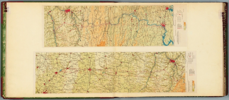
Air navigation map no. 1 (experimental) : Dayton, Ohio to Uniontown, Pa. Compiled and reproduced by the Engineer Reproduction Plant, Corps of Engineers. Under the direction of the Airways Section, Office Chief of Air Corps. 1926, Engineer Reproduction Plant, U.S. Army, Washington Barracks, D.C. 6833. R-1927. -- Air navigation map no. 2 : Washington D.C. to Uniontown, Pa. Prepared under the direction of the Airways Section, Office of the Chief of Air Corps by the Topographic Branch, U.S. Geological Survey, 1923. Revised by Engineer Reproduction Plant, U.S. Army, 1927. Engineer Reproduction Plant, U.S. Army, Washington, D.C. 6919. 1927.
List No
14501.003
Note
Two aeronautical charts representing the areas from Dayton, Ohio, to Uniontown, Pennsylvania, and from Washington D.C., to Uniontown, Pennsylvania and Wheeling, West Virginia. Features military, municipal, commercial, emergency, and seaplane landing fields. Also shows political boundaries, roads, railways, cities, towns, topography, bodies of water, and drainage. Relief shown with contour lines and color coding. Maps include latitudinal and longitudinal lines, legend, scale statements, and bar scales given in miles, as well as compass roses oriented toward top of sheet (with slight variation between the two maps). Color lithographs. Together, maps are 56 x 103 cm, on double sheet, 60 x 136 cm.
Author
[Ford Motor Company, Geological Survey (U.S.). Topographic Branch]
Full Title
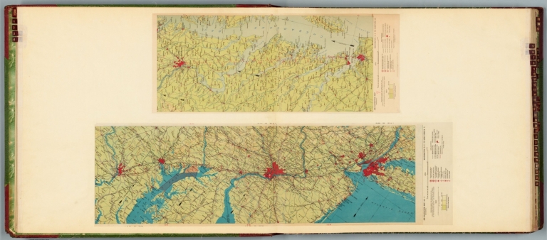
Air navigation map no. 3 (experimental) : Washington D.C. to New York, N.Y. Prepared under the direction of the Airways Section Office of the Chief of Air Service by the Topographic Branch, U.S. Geological Survey, 1923. Engineer Reproduction Plant, U.S. Army, Washington Barracks, D.C. 4915. 1923 - reprint 1926 - R-1927. -- Air navigation map [4] (experimental) : Washington D.C. to Hampton, Va. Prepared under the direction of the Airways Section, Office of the Chief of Air Corps by the Topographic Branch, U.S. Geological Survey, 1923. Engineer Reproduction Plant, U.S. Army, Washington Barracks, D.C. 6520. 1926.
List No
14501.004
Note
Two aeronautical charts representing the areas from Washington D.C., to New York, New York, and from Washington D.C. to Hampton, Virginia. Features military, municipal, commercial, emergency, and seaplane landing fields, as well as beacon lights. Also shows political boundaries, roads, railways, cities, towns, topography, bodies of water, and drainage. Relief shown with contour lines and color coding. Maps include latitudinal and longitudinal lines, legend, scale statements, and bar scales given in miles, as well as compass roses oriented toward top of sheet (with slight variation between the two maps). Color lithographs. Together, maps are 57 x 94 cm, on double sheet, 60 x 136 cm. Map number 4 provided with a handwritten annotation.
Author
[Ford Motor Company, United States. Hydrographic Office]
Full Title
U.S. Navy aviation chart : Baltimore - Washington - Norfolk. Washington, D.C., published Dec. 1925 at the Hydrographic Office, under the authority of the Secretary of the Navy. No.V-050001. Edition : 2d, April, 1925.
List No
14501.031
Note
Aeronautical chart representing the areas from Baltimore, Maryland, to Washington, D.C. and to Norfolk, Virginia. Features landing fields and seaplane anchorage. Also shows roads, railways, cities, towns, bodies of water, drainage, and coastlines. Includes latitudinal and longitudinal lines, a legend, scale statement, and bar scales given in nautical miles and miles, as well as a compass rose oriented toward top of sheet. Surrounding the chart are black and white photographic vignettes of select lighthouses and landing fields. With seal of the Hydrographic Office, U.S. Navy. Color lithograph. Chart is 72 x 41 cm, on double sheet, 136 x 60 cm.
Author
Nell, Louis
Full Title
Baltimore And its Neighborhood. An Excursion Map Compiled for the Johns Hopkins University. Based upon the Triangulation of the U.S. Coast And Geodetic Survey, And Published Maps of Local Surveys. Edited by Albert L. Webster. Drawn by Louis Nell ... Second Edition To be further revised. Baltimore. Publication Agency of the Johns Hopkins University. 1887.
List No
0663.002
Author
Trans World Airlines
Full Title
Map no. 1 : New York - Pittsburgh, Boston, Philadelphia, Washington, Baltimore. General Drafting Co. Inc., N.Y.
List No
14394.003
Note
Map of the air routes connecting New York, Pittsburgh, Boston, Philadelphia, Washington D.C. and Baltimore, as well as the greater vicinity. Also shows cities, airports, highways, railways, topography, bodies of water, coastlines, islands and time zones. Relief shown with shading and peak heights. Includes a legend and descriptive text, as well as notes throughout. With views featuring popular tourist sites, such as the Statue of Liberty of New York. Also with inset index map indicating the geographic location of the main map within the United States. Colored lithograph. Map is 26 x 42 cm, on double sheet 26 x 52 cm.
Author
Appleton, D. & Co.
Full Title
Map of Baltimore, Maryland. Copyright 1891 by Matthews-Northrup Co. ... Buffalo, New York. (to accompany) The Library Atlas Of Modern Geography ... New York, D. Appleton And Company 1892. (on upper margin) Baltimore. 102.
List No
0026.268
Note
Color plan. Shows railways, street car lines, city blocks, buildings, parks, etc. Includes numerical references to depots, hotels, churches, major buildings, and points of interest.
Author
Bradford, Thomas G.
Full Title
Baltimore. Entered ... 1838, by T.G. Bradford ... Massachusetts. Engraved by G.W. Boynton.
List No
0089.024
Note
In full color. Baltimore College and Battle Monument are noted.
Author
Colton, G.W.
Full Title
City Of Baltimore Maryland. Published by J.H. Colton & Co. 172 William St. New York. Entered ... 1855 by J.H. Colton & Co. ... New York. No. 23.
List No
0149.029
Note
In full color by region. The city is divided into a series of unreferenced numbers.
Author
Colton, G.W.
Full Title
Dalton's City of Baltimore, Maryland. Published By J. H. Colton. No. 172 William St. New York.
List No
0151.036
Author
Colton, G.W.
Full Title
Colton's Baltimore, Maryland. Published By G. W & C. B. Colton & Co. No. 172 William St. New York.
List No
0152.034
Author
Gray, O.W.
Full Title
Gray's Atlas Map of Baltimore, Maryland.
List No
0310.045
Author
[Gray, Frank A., Gray, O.W.]
Full Title
Gray's New Map of Baltimore by Frank A. Gray. Copyright 1876 by O.W. Gray & Son. (inset) Patapsco River and the Approaches.
List No
0312.019
Author
Mitchell, Samuel Augustus
Full Title
A New Map Of Maryland and Delaware with their Canals, Roads & Distances. (with) Baltimore. Published By S. Augustus Mitchell, N.E. corner of Market & 7th Street Philada., 1846. Entered ... 1846 by H.N. Burroughs ... Pennsylvania.
List No
0537.016
Note
Full color by county with steamboat route distances noted.
Author
Mitchell, Samuel Augustus
Full Title
A New Map of Maryland and Delaware, with their Canals, Roads & Distances. Published By S. Augustus Mitchell. N.E. corner of Market & 7th. Streets. Philadelphia. (inset map) Baltimore.
List No
0545.019
Note
Full color map. Includes Explanation chart, and reference to Steam boat routes. Prime meridian is Washington, D.C. Relief shown by hachures.
Author
Mitchell, Samuel Augustus
Full Title
Plan Of Baltimore. 21. Entered ... 1860, by S. Augustus Mitchell, Jr. ... Pennsylvania.
List No
0565.014
Note
City in full color with areas of the city numbered.
Author
Mitchell, Samuel Augustus Jr.
Full Title
Plan of Baltimore. Entered ... 1860 by S. Augustus Mitchell, Jr. ... Pennsylvania.
List No
0572.022
Note
Full color map.
Author
Mitchell, Samuel Augustus Jr.
Full Title
Plan of Baltimore. Entered ... 1867 by S. Augustus Mitchell, Jr. ... Pennsylvania.
List No
0579.022
Note
Color map. Showing roads, railroads, public buildings, ect.
Author
Mitchell, Samuel Augustus
Full Title
Plan of Baltimore. Entered ... 1879 by S. Augustus Mitchell ... Washington. (1880)
List No
0586.021
Note
Hand colored. Shows wards, major buildings, railroads, etc.
Author
Mitchell, Samuel Augustus Jr.
Full Title
Plan of Baltimore. Copyright by S. Augustus Mitchell 1884.
List No
0592.022
Note
Hand colored. Shows wards, major buildings, railroads, etc.
Full Title
Plan of Baltimore. Copyright 1887 by Wm. M. Bradley & Bro. (1890)
List No
0594.021
Note
Hand colored. Shows wards, major buildings, railroads, etc.
Author
Tanner, Henry S.
Full Title
A New Map Of Maryland and Delaware with their Canals, Roads & Distances. by H.S. Tanner. E. Gillingham Sc. (with) Baltimore. Entered ... 1833 by H.S. Tanner ... Pennsylvania. Published by H.S. Tanner, Philadelphia. (above neat line) Tanner's Universal Atlas.
List No
0977.013
Note
In full color by county with inset in color by area. Route distances via steamboat charted.
Author
Tanner, Henry S.
Full Title
Baltimore. (to accompany) The American Traveller; Or Guide Through the United States. Containing Brief Notices of the Several States, Cities, Principal Towns ... Third Edition. By H.S. Tanner. Philadelphia: Published by the Author, No. 51 South Third Street. 1837. (on verso) Entered ... 1836, by H.S. Tanner ... Pennsylvania. (on recto of title page: view of) " Falls Of Niagara. From the American ladder. Drawn by T. Birch. Engraved by J.W. Steel.
List No
0978.007
Note
Uncolored map. With references to places. 3rd edition; 1st was 1834; map unchanged. Catalog of Tanner's works at end of book. 144 page Guide Book with four maps of city plans. Fifth map is a large colored map entitled, "The Traveller's Guide or Map of the Roads, Canals & Rail Roads of the United States, With the distances from place to place by H.S. Tanner." At bottom of map, "Entered ... 1834, by H.S. Tanner ... Pennsylvania." Bound with linen embossed with a rose pattern. Label on cover states, "Tanner's American Traveller, or Guide through the United States."
Author
Tanner, Henry S.
Full Title
Baltimore (to accompany) The American Traveller, or Tourists' and Emigrants' Guide Through the United States. Containing Brief Notices of the Several States, Cities, Principal Towns ... Ninth Edition, with several additional routes, and A New Map ... By H.S. Tanner. New York: Published by T.R. Tanner, 153 Broadway. 1844. (on verso) Entered ... 1844, by H.S. Tanner ... New York.
List No
0983.007
Note
Uncolored map. With references to places. Bookplate of Tanner's Map Store, N.Y. 144 page Guide Book. Includes maps and reference guides. New copyright notice of 1844 indicating that this is a very late edition; the map is changed from the earlier editions but is still copyright 1834, as in the earlier editions. Full color map entitled, "The Travellers Guide or Map of The Roads, Canals & Rail Roads of the United States, With the distances from place to place by H.S. Tanner 1844." at bottom, "Entered ... 1834, by H.S. Tanner ... Pennsylvania." Bound in linen with gild title, "Tanner's American Traveller or Guide through the United States with Maps, Plans &c."
Author
Edward A. Luzzie Company
Full Title
Map of Baltimore. Copyright 1957, Edward A. Luzzie Company. (cover title) Welcome to Baltimore : pictorial map and guide to industry, port, historical places and retail stores. (Map on verso) Baltimore -Seaport of industrial America.
List No
11237.002
Note
Pictorial map 64x41, on sheet 86x56, folded into self wrapped cover 28x21.5, with inset map of downtown Baltimore. Borders with pictorial advertisements. Map showing roads, railroads, location of various businesses, post office, public places,landmarks, industries, etc. Includes list of historical events, key to map, logo of Riggs Warfield Roloson on upper left of the map and advertisement for The Walker-Hasslinger on lower right of the map. On verso: pictorial cover, "Famous trade names of Baltimore manufacturers", map: Seaport of industrial of America" border with illustrated information on each industry and notes. On recto of cover: views of Westinghouse Electric Corporation buildings.
Author
Yardley, Richard Quincy, 1903-1979
Full Title
A Map of Johns Hopkins Hospital attempting to show the general plan, Habits of the Staff, Students & Patients curious Customs etc. and so forth. Yardley drew this.
List No
11432.000
Note
Pictorial map of Johns Hopkins Hospital, Drawn by Richard Quincy Yardley, credited below the vignette of the front of the hospital with "Yardley drew this". Border with pictorial illustrations of neighborhood businesses. Includes 1930s cartooning style illustrations throughout, including a doctor looking at an x-ray of a woman’s torso, a surgeon about to operate on a startled patient with a knife, a stork delivering a baby, the Wilmer Eye Clinic, and the Animal House. Includes a decorative compass rose at the upper right. Richard Quincy. Yardley (1903-1979) was an American editorial cartoonist, started as an artist-retoucher in the news department at the Baltimore Evening Sun in 1923 and moved into creating local news and commentary cartoons in 1934, for the Morning Sun.
Author
[Yardley, Richard Q., Oriole Cafeterias, Inc.]
Full Title
(Covers to) Oriole map of Baltimore. Complements of the Oriole Cafeterias. Yardley.
List No
11697.001
Note
Colorful promotional pictorial map of Baltimore, on sheet 45x41, folded to self wrapped cover 23x10. Published in 1947, created by Richard Q. Yardley, an editorial cartoonist for the Baltimore Sun newspaper. Produced to advertise the city's three Oriole Cafeterias. Text on verso of map focuses on Baltimore's history, the city's cultural and business attributes, plus details of the city's three Oriole Cafeterias ("Good Food is Good Health"). The map centers on the towering Washington Monument on Charles Street, completed in 1829. In the immediate vicinity are the Peabody Institute and the Walters Art Museum. Streets, and illustrations of numerous Baltimore landmarks, including the locations of the three Oriole Cafeterias, as well as historical events and places of interest depicted on the map.
Author
[Yardley, Richard Q., Oriole Cafeterias, Inc.]
Full Title
Oriole map of Baltimore. Complements of the Oriole Cafeterias. Yardley.
List No
11697.002
Note
Colorful promotional pictorial map of Baltimore, on sheet 45x41, folded to self wrapped cover 23x10. Published in 1947, created by Richard Q. Yardley, an editorial cartoonist for the Baltimore Sun newspaper. Produced to advertise the city's three Oriole Cafeterias. Text on verso of map focuses on Baltimore's history, the city's cultural and business attributes, plus details of the city's three Oriole Cafeterias ("Good Food is Good Health"). The map centers on the towering Washington Monument on Charles Street, completed in 1829. In the immediate vicinity are the Peabody Institute and the Walters Art Museum. Streets, and illustrations of numerous Baltimore landmarks, including the locations of the three Oriole Cafeterias, as well as historical events and places of interest depicted on the map.
Author
Nirenstein, Nathan
Full Title
Business Section, City of Baltimore (Maryland).
List No
12507.023
Author
[George F. Cram Company collection 1845-1955, National Highways Association]
Full Title
Maryland, Delaware and District of Columbia. The George F. Cram Company, Chicago. (to accompany) Auto trails and commercial survey of the United States.
List No
13688.043
Note
States of Maryland, Delaware and District of Columbia. Insets: District of Columbia and vicinity. And Washington: The National Capital; City of Baltimore and vicinity. Map showing main traveled highways.
Author
[George F. Cram Company collection 1845-1955, National Highways Association]
Full Title
Maryland, Delaware and District of Columbia. The George F. Cram Company, Chicago. (to accompany) Auto trails and commercial survey of the United States.
List No
13688.044
Note
States of Maryland, Delaware and District of Columbia. Insets: District of Columbia and vicinity. And Washington: The National Capital; City of Baltimore and vicinity. Map showing electric lines and administrative boundaries.
Author
Rand McNalley & Company
Full Title
Atlanta, Ga. -- Albanay, N.Y. -- Atlantic City, N. J. -- Baltimore, Md. -- Birmingham, Ala. -- Boston, Mass., and vicinity -- Buffalo, N.Y., and vicinity.
List No
14003.054
Note
7 road maps of cities. Maps include compass roses and legends. Copyright by Rand McNally & Company, Chicago, Ill. Lithographed in the U.S.A.
Author
Petri, Girolamo
Full Title
Tav. CXXVII. Province ecclesiastiche di Baltimora, Cincinnati, e vicariato della Florida.
List No
14007.310
Note
Hand-colored, engraved map showing the ecclesiastical provinces of of Baltimore and Cincinnati, as well as the apostolic vicariates of Florida. With 2 insets: (Michigan) -- (Florida). Text in delicate script circling land. Accompanied by descriptive text on facing page. In Volume III.
Author
United Electric Railways
Full Title
(Covers to) Historic Baltimore, founded in 1729 : What to see and how to see it.
List No
14063.001
Note
Covers to pocket pictorial map of Baltimore, in color.
Author
United Electric Railways
Full Title
Historic Baltimore, founded in 1729 : What to see and how to see it. Copyrighted 1929 United Railways & Electric Co. Baltimore, U.S.A. Schneidereith & Sons.
List No
14063.002
Note
Pocket pictorial map of Baltimore, in color. Shows street car and bus routes, as well as significant sites, throughout map and in vignettes in the margins. Includes a legend and a compass rose. With directions to sites in the vicinity but not included within area represented by map. Indexed to indicate historical sketches on verso of map. Map is 38 x 50 cm, on sheet 41 x 53 cm, folded to 21 x 9 cm.
Author
United Electric Railways
Full Title
(Text Page to) Historic Baltimore.
List No
14063.003
Note
Verso of pocket pictorial map of Baltimore, in color. Includes "twenty-one brief sketches suggest[ing] the wealth of Baltimore's historic interest". Sketches illustrated. Folded sections have page numbers 1-12. Map indexed to indicate the locations of these historical sites.
Author
[France. Ministère des travaux publics. Administration des routes, France. Direction des cartes, plans et archives et de la statistique graphique, École nationale des ponts et chaussées (France)]
Full Title
Baltimore. (1886). 4e Série. Pl. VII. Ministère des Travaux Publics. Ecole des Ponts et Chaussées. Lith. A. Simon, 13, R. du Val-de-Grâce. Paris.
List No
14306.097
Note
Map showing the port of Baltimore, Maryland, in 1886. Features railways, streets, bridges, parks, drainage and docks. Includes a bar scale and compass rose, with north oriented toward top of sheet. Descriptive text throughout. Lithograph in black, white and blue. Map is 27 x 42 cm, on sheet 33 x 50 cm. Bookplate title pasted to verso: Pl. VII. Baltimore. Appears in Quatrième livraison.
Author
Geological Survey (U.S.)
Full Title
Urban areas : New York, N.Y. -- Washington, D.C. - Baltimore, Md.
List No
14359.036
Note
Three maps representing urban areas in the United States, as of 1970. Maps show political boundaries, cities, railways, roads, ferry lines, national forests, mountains, bodies of water, swamps, drainage, coastlines and islands. Relief shown with labeling of mountain names and peak heights. Features population density for each city. Maps include latitudinal and longitudinal lines and scale statements. Colored lithograph. Together, maps are 42 x 32 cm, on sheet 49 x 35 cm. Index map and legend appear on page 5. Maps appear in General reference maps section.
Author
Cram, George Franklin, 1841-1928
Full Title
Map of Baltimore.
List No
14372.259
Note
Map of Baltimore, Maryland. Shows political boundaries, railroads, streets, bridges, parks, bodies of water, drainage, shorelines and islands. Map indexed to indicate place names. Colored lithograph. Map is 25 x 31 cm, on sheet 33 x 45 cm.
Author
Colton, G.W.
Full Title
Colton's Baltimore, Maryland. Published By G. W & C. B. Colton & Co., No. 182 William St. New York.
List No
1550.032
Author
[Colton, G.W., Fisher, Richard Swainson]
Full Title
Maryland, Virginia, North Carolina, and South Carolina. (inset) The District of Columbia. (inset) Vicinity of Charleston. (inset) Vicinity of Baltimore, Md.
List No
1690.074
Note
Relief shown by hachures.
Author
[Cram, George Franklin, Murray-Aaron, Eugene, 1852-1941.]
Full Title
Baltimore. Published by George F. Cram, Chicago, Ill. (to accompany) Cram's atlas of the world, ancient and modern : new census edition -- indexed.
List No
1910.074
Note
In full color. Shows wards, street cars, railroads, public buildings, parks, etc.
Author
Rand McNally and Company
Full Title
Rand, McNally & Co.'s Buffalo and Baltimore.
List No
2094.064
Note
Baltimore map at 1:45,000. Counties outlined in color. Railroads highlighted. Relief shown by hachures.
Author
[Gray, Ormando Willis, Martenet, Simon J., Walling, H. F.]
Full Title
City of Baltimore. (Published by Stedman, Brown & Lyon, Baltimore. 1873)
List No
2239.003
Note
Hand col. lithographed map. Shows wards, etc.
Author
Colton, G.W.
Full Title
Colton's City of Baltimore, Maryland.
List No
2441.062
Author
Colles, Christopher
Full Title
From Philadelphia to Annapolis Md. (59)
List No
2467.056
Note
Without color.
Author
Mitchell, Samuel Augustus
Full Title
Plan of Baltimore. Entered ... 1870 by S. Augustus Mitchell, Jr. ... Pennsylvania.
List No
2483.018
Note
Hand colored. Shows wards, major buildings, railroads, etc.
Author
Tanner, Henry S.
Full Title
Baltimore
List No
2528.004
Note
8th edition, published by H. Tanner Jr. in Philadelphia and T.R. Tanner in New York, both presumably H. Tanner senior's sons. The large map appears unchanged from the 1840 edition. Large outline color map bound in back entitled, "The Travellers Guide or Map of the Roads, Canals & Rail Roads of the United States, With the distances from place to place by H.S. Tanner." At bottom of map, "Entered ... 1834, by H.S. Tanner ... Pennsylvania." Book bound with linen and with title embossed on cover, "Tanner's American Traveller or Guide through the United States with Maps, Plans &c. 1842."
Author
[Jones, T.W., Moore, S.S.]
Full Title
Road from Philadelphia to Washington. (Maps) 16, 17 and 18. Shallus Sculp.
List No
2646.010
Note
Three uncolored maps over two pages showing the area from Baltimore to Ann Arundel County.
Author
Rand McNally and Company
Full Title
Baltimore.
List No
2790.077
Author
Cram, George Franklin
Full Title
Map of Baltimore. Map of Washington. (inset) District of Columbia.
List No
2809.092
Note
Washington map lists principal stuctures, keyed to map.
|