|
REFINE
Browse All : Images of Atlantic Seaboard
1-7 of 7
Author
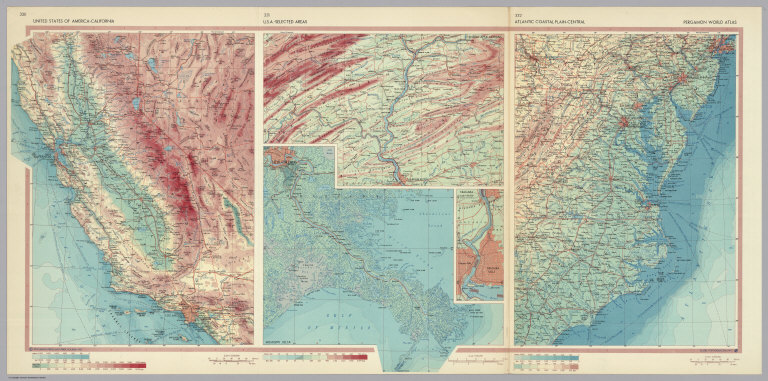
Polish Army Topography Service
Full Title
United States of America - California. U.S.A. - Selected Areas. Atlantic Coastal Plain - Central. Pergamon World Atlas. Pergamon Press, Ltd. & P.W.N. Poland 1967. Sluzba Topograficzna W.P.
List No
0737.208
Note
Detailed physical and political regional maps: California at 1:2,500,000; New Orleans and Central Appalachians at 1:500,000; Niagara at 1:100,000; Central Atlantic Coastal Plain at 1: 2,500,000.
Author
[Bellin, Jacques Nicolas, 1703-1772, Depot de la Marine]
Full Title
Carte Reduite des Costes Orientales de l'Amerique Septentrionale, Ire. Feuille. (inset) Plan du Havre de Baston.
List No
12059.094
Note
From J.F. Letenneur: "Exceptional onboard document of this rare and fabulous maritime atlas, a masterpiece by the greatest French hydrographer of the 18th century, with maps of all the coastlines known at the time. Bound with the coat of arms of the King of France, the atlas was taken by the English aboard the frigate la Nymphe, off the coasts of Ushant August 10, 1780, during one of the naval battles of the American War of Independence which took place on European waters. In the context of the war at the end of the 18th century, and of the rivalry between the French and British Navy, maritime atlases, were strategic tools, and this “Hydrographie Françoise” more so than any other, because its purpose was to provide the best maritime charts for the French ships that were fighting on the American side against the British. (The handwritten captions throughout most of the atlas are prices for individual maps and all include the same mention: “for sailors”). These atlases were not the kind to be kept in a library, but precious tools, based on the observations of the travelers and continuously improved upon, as reflect in the present copy. It was bound with the engraved title page of the edition of 1737-1765, but the index includes maps printed after 1765 (until 1772), and the copy was augmented by six maps that do not appear in the index (until 1776), as well as 14 pages of text from the Versailles edition of 1773. The later maps are signed by Verdun de la Crenne and were done during the campaigns of the Flore (1771-1772) and of the Isis led by Fleurieu in 1768-1769. The captions explain that the maps were created using the latest technology of the day that could measure longitude (maritime clocks)." (Continued in the Pub Note field).
Author
Du Val, Pierre, 1619-1683
Full Title
Carte de la Virginie.
List No
12503.040
Author
[Bayer, Herbert, Container Corporation of America]
Full Title
Eastern U.S.A.
List No
5842.040
Note
Inset is extension of main map. Relief depicted by hachures and hypsometric tints.
Author
[Civic Education Service, Phillips, Joe]
Full Title
Colonization in America, Visual History Wall Map, Prepared by Civic Education Service ... Washington D.C.
List No
8888.000
Author
General Drafting Co., Inc.
Full Title
Life in Colonial America From the Landing at Jamestown to the Revolution.
List No
8998.002
Note
Nine maps. Numerous historical vignettes. Includes colonial flags.
Author
Apgar, E.A.; Apgar, A.C.
Full Title
(Text Page and Map) Map of the Middle States. Map of the Southern States.
List No
9645.006
Note
Instructive text. Map tinted in pale pastels; also with bold red geometric figures.
1-7 of 7
|