|
Author
[Baranov, Anatolij Nikolaevič, Soviet Union. Glavnoe upravlenie geodezii i kartografii]
Full Title
Средняя азия (Восток) = Sredniaia Aziia (Vostok). 61-62. Atlas Mira : 1954.
List No
13682.075
Note
Physical map of Central East Asia. Relief shown by gradient tints, contours and spotlights. Depth shown by bathymetric tints, isolines and soundings.
Author
[Ptolemy, Claudius, Mercator, Gerhard, 1512-1594, Pirckheimer, Willibald, Mylius, Arnold]
Full Title
ASIAE: VII. TAB
List No
10991.203
Note
Hand colored outline map of Central Asia and Middle East. Relief shown pictorially.
Author
[Ptolemy, Claudius, Mercator, Gerhard, 1512-1594, Pirckheimer, Willibald, Mylius, Arnold]
Full Title
ASIAE: VIII. TAB
List No
10991.205
Note
Hand colored outline map of Central Asia. Relief shown pictorially
Author
[Chatelain Henri, 1684-1743, Gueudeville, Nicolas]
Full Title
Nouvelle Carte de Moscovie oû sont representes les differents Etats de sa Maieste Czarienne en Europe et en Asie et le Chemin dun de ses Abassadeurs a Peking Ville Capitale de l'Empereur de la Chine et son Sejour Ordinaire. Tome 4. No. 29. (to accompany) Atlas Historique ... Tome IV. A Amsterdam, chez les Freres Chatelain Libraires. M DCC XIV (1714).
List No
13272.401
Note
Engraved folded map of Russian in Asia, Siberia, Tartary and parts of China. Shows major cities, rivers, forests, lakes and mountains. Relief shown pictorially. Includes descriptive text and table of the principal places.
Author
[Smith, William, 1813-1893, Muller, Charles]
Full Title
Empire of Alexander the Great. Drawn by Dr. Charles Muller. Engraved by Edwd. Weller. London : John Murray. 1873. (to accompany) Dr. William Smith's Ancient atlas. 4. 1874.
List No
13007.024
Note
Outline hand color map. Covers the entire extent of Alexander the Great's domain. Shows major cities, rivers and mountains. Relief shown by hachures. Includes color coded reference to March of Alexander and Course of the fleet.
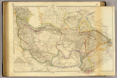
Author
[Arrowsmith, John, Burnes, Alexander, Sir.]
Full Title
Central Asia; comprising Bokhara, Cabool, Persia, the River Indus, & countries eastward of it. Constructed from numerous authentic documents, but principally from the original M.S. surveys of Lieut. Alex. Burnes, F.R.S. to whom this map is most respectfully dedicated, by his obliged servant, J. Arrowsmith. June 1834. London, pubd. 16 June by J. Arrowsmith, 35 Essex Street, Strand.
List No
0036.029
Note
Engraved map. Hand colored boundaries. Relief shown by hachures. Shows routes of Alexander Burnes. Eastern portion is a past-on on printed on thin paper.
Author
[Martin, R.M., Tallis, J. & F.]
Full Title
Independent Tartary. The Illustrations by W. Bragg & Engraved by J. Rogers. The Map Drawn & Engraved by J. Rapkin.
List No
0466.045
Note
Regions shown in outline color. Illustrations include the Tartars on a journey, their tent, and chasing a bride following the local custom. Leafy border.
Author
Mitchell, Samuel Augustus
Full Title
Russia In Asia And Tartary. (with) Western Part Of Russia.
List No
0537.064
Note
In full color by region.
Author
Mitchell, Samuel Augustus
Full Title
Russia in Asia and Tartary. (inset map) West part of Russia.
List No
0545.068
Note
Full color map. Includes explanation chart, showing capitals, important towns, etc. Relief shown by hachures. Prime meridian is Greenwich.
Author
Society for the Diffusion of Useful Knowledge (Great Britain)
Full Title
Western Siberia, Independent Tartary, Khiva, Bokhara &c. J. & C. Walker sculpt. Published by the Society for the Diffusion of Useful Knowledge, 59 Lincolns Inn Fields, Novr. 20th. 1838. (London: Chapman & Hall, 1844)
List No
0890.089
Note
Engraved map. Relief shown by hachures. Boundaries and lakes hand col. Two insets show continuations of map. Sources: Klaproth, Burnes, Piadischev and others.
Author
Society for the Diffusion of Useful Knowledge (Great Britain)
Full Title
Bokhara, Cabool, Beloochistan &c. Engraved by J. & C. Walker. Published for the Society for the Diffusion of Useful Knowledge by Chapman & Hall, 186 Strand, Augst. 15th. 1838 (1844)
List No
0890.092
Note
Engraved map. Relief shown by hachures. Boundaries hand col.
Author
Tanner, Henry S.
Full Title
Russia In Asia and Tartary. (with) Western Part Of Russia. Engraved by J. & W.W. Warr. Published by H.S. Tanner, Philadelphia. (above neat line) Tanner's Universal Atlas.
List No
0977.057
Note
In full color by region.
Author
Thomson, John
Full Title
Tartary. N.R. Hewitt sc., 10 Broad Str., Bloomsbry., London. Drawn and engraved for Thomson's New general atlas, Sepr. 1st., 1814.
List No
1007.040
Note
Engraved map. Outline hand color. Relief shown by hachures.
Author
[Martin, R.M., Tallis, J. & F.]
Full Title
Independent Tartary. The Illustrations by W. Bragg & Engraved by J. Rogers. The Map Drawn & Engraved by J. Rapkin.
List No
10095.046
Note
Regions shown in outline color. Illustrations include the Tartars on a journey, their tent, and chasing a bride following the local custom. Leafy border.
Full Title
Central Asia and India. (Published at the office of "The Times," London, 1895)
List No
1010.051
Note
Color map. Relief shown by hachures and spot heights. Shows settlements, rivers, etc.
Author
[Ptolemy, Claudius, D'Angelo, Jacopo, Regiomontanus, Joannes, Pirckheimer, Willibald, Grueninger, Johann]
Full Title
Tabula VII Asiae
List No
10891.067
Author
[Ptolemy, Claudius, D'Angelo, Jacopo, Regiomontanus, Joannes, Pirckheimer, Willibald, Grueninger, Johann]
Full Title
(Tabula VIII Asiae)
List No
10891.070
Author
[Gorkin, Aleksandr Fedorovich, Kutafʹev, S. A.]
Full Title
Ekonomicheskaia karta : Uzbekskoy SSR. Ekonomicheskaia karta : Ferganskoy Dolina. Bolshoi Sovietskii Atlas Mira II. Moskva 1939.
List No
11008.317
Note
2 maps on folded sheet 69x51. Including economic and industrial maps of Uzbekistan and Fergana Valley in Central Asia. With inset.
Author
[Gorkin, Aleksandr Fedorovich, Kutafʹev, S. A.]
Full Title
Tadzhikskaia SSR. Tadzhikskaia SSR. Ekonomicheskaia karta. (to accompany) Bolshoi Sovietskii Atlas Mira II. Moskva 1939.
List No
11008.319
Note
2 maps on sheet 69x51. Including physical and economic maps of Tajikistan SSR. With 2 insets.
Author
[Gorkin, Aleksandr Fedorovich, Kutafʹev, S. A.]
Full Title
Kirgizskaia SSR. Ekonomicheskaia karta : Kirgizskoy SSR. Bolshoi Sovietskii Atlas Mira II. Moskva 1939.
List No
11008.325
Note
2 maps on sheet 69x51. Including physical and economic maps of Kyrgyzstan. With 2 insets.
Author
[Gorkin, Aleksandr Fedorovich, Kutafʹev, S. A.]
Full Title
Grazhdanskaia Voyna v SSSR. 1917-1922. Bolshoi Sovietskii Atlas Mira II. Moskva 1939.
List No
11008.337
Note
2 maps of the Russian Civil War on sheet 51x31. Including Civil War in in Central Asia and Kazakhstan, 1917-1922.
Author
[Bertius, Petrus, 1565-1629, Mercator, Gerhard, 1512-1594, Ptolemy, Claudius]
Full Title
Asiae,VII Tab. Tabvlarvm Ptolemaicarvm delineatio ... Ex Clavdii Ptolemaei geogrophicis libris octo orbem totum habitabilem Agathodaemon Alexandrinus mechanicus delineauit. Has vero tabulas descripsit Gerardvs Mercator ... Recensuit varie, correxit, auxitq Petrvs Bertivs ... (to accompany) Theatrum geographiae veteris, duobus tomis distinctum, edente Petro Bertio Bevero.
List No
11296.056
Note
Hand colored outline map of Central Asia and Middle East. Relief shown pictorially.
Author
[Bertius, Petrus, 1565-1629, Mercator, Gerhard, 1512-1594, Ptolemy, Claudius]
Full Title
Asiae, VIIITab.Tabvlarvm Ptolemaicarvm delineatio ... Ex Clavdii Ptolemaei geogrophicis libris octo orbem totum habitabilem Agathodaemon Alexandrinus mechanicus delineauit. Has vero tabulas descripsit Gerardvs Mercator ... Recensuit varie, correxit, auxitq Petrvs Bertivs ... (to accompany) Theatrum geographiae veteris, duobus tomis distinctum, edente Petro Bertio Bevero.
List No
11296.058
Note
Hand colored outline map of Central Asia. Relief shown pictorially.
Author
[Ptolemy, Claudius, Ruscelli,Girolamo, Rosaccio, Giuseppe]
Full Title
Tabvla Asiae VII. Della Geografia di Tolomeo. Libro Sesto. (to accompany) Geographia di Clavdio Tolomeo alessandrino, tradotta di Greco nell'idioma volgare Italiano da Girolamo Ruscelli ... In Venetia, MDXCIX (1599) Appresso gli heredi di M. Sessa.
List No
11299.027
Note
Engraved map of the region east of the Caspian Sea including present-day Kazakhstan, Uzbekistan, Turkmenistan, Afghanistan, and part of Iran. Relief shown pictorially.
Author
[Ptolemy, Claudius, Ruscelli, Girolamo, Giuseppe Moletti, M.]
Full Title
Tabvla Asiae VII. Dell' Asia,Tavola Settima antica. (To accompany) La geografia di Claudio Tolomeo Alessandrino, nuouamente tradotta di Greco in Italiano, da Girolamo Ruscelli ... In Venetia, Appresso Vincenzo Valgrisi, M.D.LXI. (1561).
List No
11311.050
Note
Engraved map of the region east of the Caspian Sea including present-day Kazakhstan, Uzbekistan, Turkmenistan, Afghanistan, and part of Iran. Relief shown pictorially.
Author
[Ptolemy, Claudius, Ruscelli, Girolamo, Giuseppe Moletti, M.]
Full Title
Tabvla Asiae IX. Dell' Asia,Tavola Nona antica. (To accompany) La geografia di Claudio Tolomeo Alessandrino, nuouamente tradotta di Greco in Italiano, da Girolamo Ruscelli ... In Venetia, Appresso Vincenzo Valgrisi, M.D.LXI. (1561).
List No
11311.054
Note
Engraved map covering central Asia. Relief shown pictorially.
Author
[Ptolemy, Claudius, Fries, Lorenz, Servetus, Michael]
Full Title
Tabvla septima Asiae. (to accompany) Claudii Ptolemaei Alexandrini Geographicae enarrationis libri octo. Sed ad Graeca & prisca exemplaria a Michaele Villanouano secundo recogniti & locis innumeris denuo castigati. Prostant Lugduni Apud Hugonem a Porta. M.D.XLI. (1541).
List No
11325.046
Note
Engraved map showing the region north and east of the Caspian Sea.
Author
[Ptolemy, Claudius, Fries, Lorenz, Servetus, Michael]
Full Title
Tabvla octava Asiae continet. (to accompany) Claudii Ptolemaei Alexandrini Geographicae enarrationis libri octo. Sed ad Graeca & prisca exemplaria a Michaele Villanouano secundo recogniti & locis innumeris denuo castigati. Prostant Lugduni Apud Hugonem a Porta. M.D.XLI. (1541).
List No
11325.048
Note
Engraved map of central Asia, showing ancient Schytia Extra Imaum and the kingdom of Serica.
Author
[Ptolemy, Claudius, Gastaldi, Giacomo, Mattioli, Pietro Andrea, 1500-1577, Pedrezano, Giovanbattista]
Full Title
Tabula Asiae II. (to accompany) Ptolemeo. La geografia di Claudio Ptolemeo alessandrino ... In Venetia, ... per Gioan. Baptista Pedrezano ... Anni x. M.D.XLVIII (1548).
List No
11479.085
Note
Engraved ancient map of the region north of the Black and Caspian seas showing the ancient kingdom of Sarmatia. Shows political boundaries, cities, towns, landmarks, rivers and mountains. Relief shown pictorially.
Author
[Ptolemy, Claudius, Gastaldi, Giacomo, Mattioli, Pietro Andrea, 1500-1577, Pedrezano, Giovanbattista]
Full Title
Tabula Asiae III. (to accompany) Ptolemeo. La geografia di Claudio Ptolemeo alessandrino ... In Venetia, ... per Gioan. Baptista Pedrezano ... Anni x. M.D.XLVIII (1548).
List No
11479.089
Note
Engraved ancient map of the region between the Black and Caspian seas. Covers Armenia, Caspian Sea, Iran, Turkey, Azerbaijan and Russia. Noah's Ark is shown in the Caspian Sea. Shows boundaries, cities, towns, landmarks, rivers and mountains. Relief shown pictorially.
Author
[Ptolemy, Claudius, Gastaldi, Giacomo, Mattioli, Pietro Andrea, 1500-1577, Pedrezano, Giovanbattista]
Full Title
Tabula Asiae VII. (to accompany) Ptolemeo. La geografia di Claudio Ptolemeo alessandrino ... In Venetia, ... per Gioan. Baptista Pedrezano ... Anni x. M.D.XLVIII (1548).
List No
11479.103
Note
Engraved ancient map of Central Asia up to India including the area between the Persian Gulf and the Caspian Sea. Shows settlements, towns, landmarks, rivers and mountains. Relief shown pictorially.
Author
[Harrison, Richard Edes, St. Louis Post dispatch]
Full Title
The Eurasian land mass. Richard Edes Harrison. Special Atlas Section - St. Louis Post Dispatch. Sunday, September 12, 1954.
List No
11507.004
Note
Color map, with descriptive text and population of cities on 2 pages. Shows political and administrative divisions, and place names. Relief shown by shadings and spot heights. Note 'This map originally appeared in Fortune magazine and is reprinted by special permission. Copyright by TIME Inc."
Author
Sanson, Nicolas, 1600-1667
Full Title
L'Empire du Grand Mogol. Par N. Sanson d'Abb. Geographe du Roy. Avec privilege pour 20 Ans. A. Peyrounin Sculp. 1652. (to accompany) L'Asie en plvsievrs cartes novvelles, et exactes ... A Paris, Chez l'Autheur.
List No
11574.039
Note
Copper engraved double page, hand colored in outline map of Mogol Empire, with decorative cartouche. Showing political boundaries, major cities, towns, villages, rivers, mountains, drainage, etc. Relief shown pictorially.
Author
Zatta, Antonio, active 1757-1797
Full Title
La Tartaria Indipendente Che comprende il Paese de' Calmuchi quello degli Usbeks, e il Turkestan Co le loro dipendenze. Venezia 1784. Presso Antonio Zatta, e Figli. (to accompany) Atlante novissimo ... Tomo IIII. Con privilegio dell Eccelimo Senato. (tomo I-IV).
List No
11598.211
Note
Engraved hand-colored in outline, double-page map, with decorative title cartouche. Covers the region from the Caspian Sea to Bhutan. Shows political and administrative divisions, cities, towns, rivers and mountains. Relief shown pictorially.
Author
[Munster, Sebastian, 1448–1552, Ptolemy, Claudius, Pirckheimer, Willibald, 1470-1530]
Full Title
Tabula Asiae VII. (to accompany) Geographia universalis, vetus et nozva, complectens Claudii Ptolemaei Alexandrini enarrationis libros VIII ... Basileae apud Henricum Petrum Mense Martio anno M.D. XL (1540).
List No
11623.053
Note
Woodcut uncolored 7th. map of Asia. Covers Central Asia and Russia. Shows cities, towns, land marks, rivers and mountains. Relief shown pictorially. Includes notes.
Author
Aa, Pieter van der, 1659-1733
Full Title
La Grande Tartarie, Suivant les nouvelles observations de Messrs ... A Leide, Chez Pierre Van der Aa. (to accompany) Nouvel Atlas, tres-exact et fort commode pour toutes sortes de personnes, Contenant les Principales Cartes Geographiques ...
List No
11691.094
Note
Full color map of Central Asia, with decorative cartouche. Showing political and administrative boundaries. Relief shown pictorially.
Author
[Arrowsmith, John, 1790-1873, Stanford, Edward, 1827-1904]
Full Title
Sketch of the acquisitions of Russia in Europe and Central Asia since the accession of Peter 1st to the Throne. London: Edward Stanford, 55 Charing Cross, S.W. Feb. 1st. 1884. (to accompany) Stanford's London Atlas Of Universal Geography. Folio edition.
List No
11741.033
Note
Outline hand color folded map of Russia in Europe. Showing political divisions, cities, towns, landmarks, roads, railroads, canals, parks, mountains and rivers. Includes note and table "Population of the Russian Empire at different epochs, according to the best Authorities."
Author
[Arrowsmith, John, 1790-1873, Stanford, Edward, 1827-1904]
Full Title
Central Asia, 1884. London: Edward Stanford, 55 Charing Cross, S.W. July 1st, 1884. (to accompany) Stanford's London Atlas Of Universal Geography. Folio edition.
List No
11741.038
Note
Outline hand color folded map. Showing political divisions, cities, towns, landmarks, roads, mountains and rivers. Relief shown by hachures and pictorially. Prime meridian is Greenwich.
Author
Bartholomew, J. G. (John George), 1860-1920
Full Title
Section II. (Chinese Turkistan). Plate 23. The Edinburgh Geographical Institute. Copyright John Bartholmew & Co. (to accompany) Constable's Hand Atlas of India : a new series of sixty maps and plans ... J. G. Batholomew ... Westminster : Archibald Constable & Company, MDCCCXCIII (1893).
List No
11794.028
Note
Color map. Covers Kashmir and Jammu. Showing political and administrative boundaries, cities, towns, roads, rivers, lakes and mountains. Relief shown by formlines and spot heights.
Author
[Smith, William, 1813-1893, Muller, Charles]
Full Title
Kingdoms of the successors of Alexander in the middle of the third century. (to accompany) Dr. William Smith's Ancient atlas. 5. 1874. (insets) Kingdoms of the successors of Alexander after the division at Babylon (323) and Triparadisus (321). (with) Kingdoms of the successors of Alexander after the battle of Ipsus (301 B.C.).
List No
13007.025
Note
Outline hand color map. Shows major cities, rivers and mountains. Relief shown by hachures. Includes color coded reference.
Author
[Smith, William, 1813-1893, Muller, Charles]
Full Title
Kingdoms of the successors of Alexander after the battle of Magnesia (190 B.C.) . Drawn by Dr. Charles Muller. Engraved by Edwd. Weller. London : John Murray. 1873. (to accompany) Dr. William Smith's Ancient atlas. 6. 1874. (inset) Empire of the Parthians.
List No
13007.026
Note
Outline hand color map. Shows major cities, rivers and mountains. Relief shown by hachures. Includes color coded reference.
Author
Hellert, J. J.
Full Title
Tatarie et Turkistan. Gravee par U. Muschani. Imprime chez Thierry Freres. Atlas de l'Empire Ottoman, par J.J. Hellert. Planche XXII. (to accompany) Nouvel atlas physique, politique, et historique de l'Empire Ottoman... 1844.
List No
13229.031
Note
Engraved map. Shows major cities and towns. Relief shown by hachures. Prime meridian is Ferro. Includes index.
Author
[Berghaus, Heinrich, 1797-1884, Sohr, Karl, Flemming, Carl]
Full Title
Westliches Hochasien. Entworfen u. gezeichnet v. Handtke. Lith v. H. Muller. Druck u. Verlag v. C. Flemming in Glogau. (to accompany) Vollstandiger Universal-Handatlas der neueren Erdbeschreibung ,,, Heinrich Berghaus ... 1859.
List No
13250.101
Note
Hand colored in outline map. Includes color coded key and legend. Relief shown by hachures.
Author
[Chatelain Henri, 1684-1743, Gueudeville, Nicolas]
Full Title
Carte Nouvelle de la Grande Tartarie ou de l'Empire du Grand Cham, Dresee sur les memoires Originaux & sur d'autres observations tres exactes de divers Voyageurs. Tom. V. No. 33. Pag. 87. (to accompany) Atlas Historique ... Tom. V. A Amsterdam, chez L'Honore & Chatelain Libraires. M DCC XIX (1719).
List No
13272.525
Note
Engraved folded map of Northern China, Korea, Russia from the Caspian Sea to Korea. Includes notations and descriptive text. Shows boundaries and major cities. Relief shown pictorially.
Author
[Chatelain Henri, 1684-1743, Gueudeville, Nicolas]
Full Title
Genealogie des anciens Empereurs Tartares, Descendus de Genghiscan. Tom. V. No. 34. Pag. 94. (to accompany) Atlas Historique ... Tom. V. A Amsterdam, chez L'Honore & Chatelain Libraires. M DCC XIX (1719).
List No
13272.531
Note
Engraved map of Tartaria Magna, with genealogical tree of the descendants of Ghengis Khan. Includes historical text.
Author
[Chatelain Henri, 1684-1743, Gueudeville, Nicolas]
Full Title
Genealogie des Empereurs Mogols depuis Tamberlan ou Tamerlan jusques a present. Tom. V. No. 35. Pag. 110. (to accompany) Atlas Historique ... Tom. V. A Amsterdam, chez L'Honore & Chatelain Libraires. M DCC XIX (1719).
List No
13272.538
Note
Two engraved maps: Carte de l'empire du grand Mogol; Carte nouvelle du royaume de Kachemire, with genealogical tree in the center and in the lower part three scenes: : an elephant fight; the king measuring his weight in gold; and the ceremony of cremation. Includes descriptive text.
Author
Esref, Mehmed, 1847-1912
Full Title
(Asya. Avrupa = Asia. Europe). (to accompany) Tarih-i umumi ve ʻOsmanii : aṭlasi = Historical atlas of the world and Ottoman. Mehmed Esref. 1329 (1913).
List No
13431.020
Note
2 color maps, with 6 insets on double page sheet. Shows Islam in East and Central Asia, Central and Southern Europe, and part of Africa. Includes color coded reference.
Author
Hafız Ali Eşref
Full Title
Asya Osmanı ve Asya Wasati = Turkey in Asia and Middle East. (to accompany) Yeni atlas = First atlas. Mülâzim-i evvel Hafız Ali Eşref. Paris. 1285 (1868).
List No
13529.025
Note
Color map of Asia Minor, Central Asia and Middle East. Shows political and administrative boundaries.
Author
[Spruner von Merz, Karl, 1803-1892., Menke, Heinrich Theodor]
Full Title
(Asia) : Reich der Mongolen. Von Theodor Menke. Gezeichnet von F. Hein. Spruner-Menke Hist. Hand-Atlas No. 87. Gotha : Justus Perthes 1877.
List No
13561.113
Note
5 maps of Central Asia on 1 sheet. Including: Reiche d. Khwarizmschah. d. Ghuriden 1204-1226. Reich der Mongolen, unter Ǵingizkhan (1167/8-1227) und seinen Nachfolgern 1226-1268. Reich der Mongolen unter Kubilai (1260-1294) u. seinen Nachfolgern 1262-1342. Nachfolger der Ilkhane 1342-1394. Reich des Tîmur 1394-1405.
Author
Stieler, Adolf, 1775–1836
Full Title
Nord- & Mittel-Asien, Ubersicht Des Russischen Reiches. Von A. Petermann. Bearbeitet v. Hanemann. Gest v. Kuhn, Terrain v. Kramer. Stieler's Hand-Atlas No. 59. Gotha: Justus Perthes. 1874.
List No
13563.080
Note
Outline color map of North and Central Asia. Includes Russian Empire, Mongolia, and Japan.
|