|
Author
[Fisk, Harold N., 1908-1964, Mississippi River Commission, United States. Army. Corps of Engineers]
Full Title
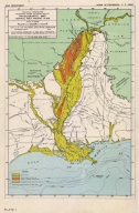
Plate 1 Physiographic Map Central Gulf Coast Plain.
List No
15845.001
Author
[Fisk, Harold N., 1908-1964, Mississippi River Commission]
Full Title
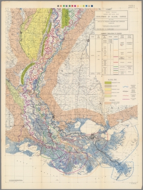
Plate 2 Sheet 1 Alluvial Valley of the Mississippi River. Development of the Alluvial Surface.
List No
15845.002
Author
[Fisk, Harold N., 1908-1964, Mississippi River Commission]
Full Title
Plate 2 Sheet 2 Alluvial Valley of the Mississippi River. Development of the Alluvial Surface.
List No
15845.003
Author
[Fisk, Harold N., 1908-1964, Mississippi River Commission]
Full Title
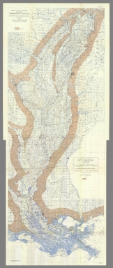
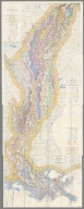
(Composite map of) Plate 2 Sheets 1-2 Alluvial Valley of the Mississippi River. Development of the Alluvial Surface.
List No
15845.004
Author
[Fisk, Harold N., 1908-1964, Mississippi River Commission]
Full Title
Plate 3 Sheet 1 Alluvial Valley of the Mississippi River. Entrenched Valley System.
List No
15845.005
Author
[Fisk, Harold N., 1908-1964, Mississippi River Commission]
Full Title
Plate 3 Sheet 2 Alluvial Valley of the Mississippi River. Entrenched Valley System.
List No
15845.006
Author
[Fisk, Harold N., 1908-1964, Mississippi River Commission]
Full Title
(Composite map of) Plate 3 Sheets 1-2 Alluvial Valley of the Mississippi River. Entrenched Valley System.
List No
15845.007
Author
[Fisk, Harold N., 1908-1964, Mississippi River Commission]
Full Title
Plate 10 Sheet 1 Alluvial Valley of the Mississippi River. Geological Map Alluvial Valley Floor.
List No
15845.008
Author
[Fisk, Harold N., 1908-1964, Mississippi River Commission]
Full Title
Plate 10 Sheet 2 Alluvial Valley of the Mississippi River. Geological Map Alluvial Valley Floor.
List No
15845.009
Author
[Fisk, Harold N., 1908-1964, Mississippi River Commission]
Full Title
(Composite map of) Plate 10 Sheets 1-2 Alluvial Valley of the Mississippi River. Geological Map Alluvial Valley Floor.
List No
15845.010
Author
[Fisk, Harold N., 1908-1964, Mississippi River Commission]
Full Title
Plate 12 Sheet 1 Alluvial Valley of the Mississippi River. Top of Graveliferous Alluvium.
List No
15845.011
Author
[Fisk, Harold N., 1908-1964, Mississippi River Commission]
Full Title
Plate 12 Sheet 2 Alluvial Valley of the Mississippi River. Top of Graveliferous Alluvium.
List No
15845.012
Author
[Fisk, Harold N., 1908-1964, Mississippi River Commission]
Full Title
(Composite map of) Plate 12 Sheets 1-2 Alluvial Valley of the Mississippi River. Top of Graveliferous Alluvium.
List No
15845.013
Author
[Fisk, Harold N., 1908-1964, Mississippi River Commission]
Full Title
Plate 15 Sheet 1 Alluvial Valley of the Mississippi River. Stream Courses.
List No
15845.014
Author
[Fisk, Harold N., 1908-1964, Mississippi River Commission]
Full Title
Plate 15 Sheet 2 Alluvial Valley of the Mississippi River. Stream Courses.
List No
15845.015
Author
[Fisk, Harold N., 1908-1964, Mississippi River Commission]
Full Title
Plate 15 Sheet 3 Alluvial Valley of the Mississippi River. Stream Courses.
List No
15845.016
Author
[Fisk, Harold N., 1908-1964, Mississippi River Commission]
Full Title
Plate 15 Sheet 4 Alluvial Valley of the Mississippi River. Stream Courses.
List No
15845.017
Author
[Fisk, Harold N., 1908-1964, Mississippi River Commission]
Full Title
(Composite map of) Plate 15 Sheets 1- 4 Alluvial Valley of the Mississippi River. Stream Courses.
List No
15845.018
Author
[Fisk, Harold N., 1908-1964, Mississippi River Commission]
Full Title
Plate 22 Sheet 1 Alluvial Valley of the Mississippi River. Ancient Courses Mississippi River Meander Belt. Cape Girardeau, Mo. - Donaldsonville, LA.
List No
15845.019
Author
[Fisk, Harold N., 1908-1964, Mississippi River Commission]
Full Title
Plate 22 Sheet 2 Alluvial Valley of the Mississippi River. Ancient Courses Mississippi River Meander Belt. Cape Girardeau, Mo. - Donaldsonville, LA.
List No
15845.020
Author
[Fisk, Harold N., 1908-1964, Mississippi River Commission]
Full Title
Plate 22 Sheet 3 Alluvial Valley of the Mississippi River. Ancient Courses Mississippi River Meander Belt. Cape Girardeau, Mo. - Donaldsonville, LA.
List No
15845.021
Author
[Fisk, Harold N., 1908-1964, Mississippi River Commission]
Full Title
Plate 22 Sheet 4 Alluvial Valley of the Mississippi River. Ancient Courses Mississippi River Meander Belt. Cape Girardeau, Mo. - Donaldsonville, LA.
List No
15845.022
Author
[Fisk, Harold N., 1908-1964, Mississippi River Commission]
Full Title
Plate 22 Sheet 5 Alluvial Valley of the Mississippi River. Ancient Courses Mississippi River Meander Belt. Cape Girardeau, Mo. - Donaldsonville, LA.
List No
15845.023
Author
[Fisk, Harold N., 1908-1964, Mississippi River Commission]
Full Title
Plate 22 Sheet 6 Alluvial Valley of the Mississippi River. Ancient Courses Mississippi River Meander Belt. Cape Girardeau, Mo. - Donaldsonville, LA.
List No
15845.024
Author
[Fisk, Harold N., 1908-1964, Mississippi River Commission]
Full Title
Plate 22 Sheet 7 Alluvial Valley of the Mississippi River. Ancient Courses Mississippi River Meander Belt. Cape Girardeau, Mo. - Donaldsonville, LA.
List No
15845.025
Author
[Fisk, Harold N., 1908-1964, Mississippi River Commission]
Full Title
Plate 22 Sheet 8 Alluvial Valley of the Mississippi River. Ancient Courses Mississippi River Meander Belt. Cape Girardeau, Mo. - Donaldsonville, LA.
List No
15845.026
Author
[Fisk, Harold N., 1908-1964, Mississippi River Commission]
Full Title
Plate 22 Sheet 9 Alluvial Valley of the Mississippi River. Ancient Courses Mississippi River Meander Belt. Cape Girardeau, Mo. - Donaldsonville, LA.
List No
15845.027
Author
[Fisk, Harold N., 1908-1964, Mississippi River Commission]
Full Title
Plate 22 Sheet 10 Alluvial Valley of the Mississippi River. Ancient Courses Mississippi River Meander Belt. Cape Girardeau, Mo. - Donaldsonville, LA.
List No
15845.028
Author
[Fisk, Harold N., 1908-1964, Mississippi River Commission]
Full Title
Plate 22 Sheet 11 Alluvial Valley of the Mississippi River. Ancient Courses Mississippi River Meander Belt. Cape Girardeau, Mo. - Donaldsonville, LA.
List No
15845.029
Author
[Fisk, Harold N., 1908-1964, Mississippi River Commission]
Full Title
Plate 22 Sheet 12 Alluvial Valley of the Mississippi River. Ancient Courses Mississippi River Meander Belt. Cape Girardeau, Mo. - Donaldsonville, LA.
List No
15845.030
Author
[Fisk, Harold N., 1908-1964, Mississippi River Commission]
Full Title
Plate 22 Sheet 13 Alluvial Valley of the Mississippi River. Ancient Courses Mississippi River Meander Belt. Cape Girardeau, Mo. - Donaldsonville, LA.
List No
15845.031
Author
[Fisk, Harold N., 1908-1964, Mississippi River Commission]
Full Title
Plate 22 Sheet 14 Alluvial Valley of the Mississippi River. Ancient Courses Mississippi River Meander Belt. Cape Girardeau, Mo. - Donaldsonville, LA.
List No
15845.032
Author
[Fisk, Harold N., 1908-1964, Mississippi River Commission]
Full Title
Plate 22 Sheet 15 Alluvial Valley of the Mississippi River. Ancient Courses Mississippi River Meander Belt. Cape Girardeau, Mo. - Donaldsonville, LA.
List No
15845.033
Author
[Fisk, Harold N., 1908-1964, Mississippi River Commission]
Full Title
(Composite map of) Plate 22 Sheets 1-15 Alluvial Valley of the Mississippi River. Ancient Courses Mississippi River Meander Belt. Cape Girardeau, Mo. - Donaldsonville, LA.
List No
15845.034
Note
To view this map in desktop Google Earth, install Google Earth Pro, download this link and open it in Google Earth by double clicking on the file.
https://rumseygeo.s3.amazonaws.com/15845035mercator2/doc.kml
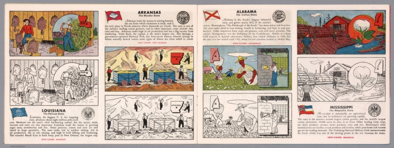
Author
[Fisher, Joseph R., Planters Peanuts (Firm)]
Full Title
Louisiana : The pelican state -- Arkansas : The wonder state -- Alabama : The cotton state -- Mississippi : The magnolia state.
List No
14374.012
Note
Four views, representing Louisiana, Arkansas, Alabama and Mississippi. Views show examples of the landscape and natural resources. Each view includes an inset map of the state, which marks the location of the capital city with a star. Accompanied by descriptive text, the state flags, seals and flowers: magnolia, apple blossom, goldenrod and magnolia, respectively. The view of each state appears both in color (on top) and in black and white (bottom), the latter inviting coloration. Together, views are 18 x 52 cm, on two sheets 20 x 54 cm.
Author
Burr, David H., 1803-1875
Full Title
Map of Mississippi, Louisiana & Arkansas Exhibiting the Post Offices, Post Roads, Canals, Rail Roads, &c. By David H. Burr. (Late Topographer to the Post Office.) Geographer to the House of Representatives of the U.S. John Arrowsmith. Entered ... July 10th, 1839, by David H. Burr ... District of Columbia.
List No
0104.009
Note
In full color by county. Postal routes by coach, stage, sulkey, cross, rail roads and canals shown. In 8 sections mounted on linen. Label on back states "No. 9. Mississippi, Louisiana, Arkansas."
Author
Cram, George Franklin
Full Title
New Rail Road and County Map of Arkansas, Louisiana, & Mississippi.
List No
0210.034
Note
Prime meridians Greenwich and Washington.
Full Title
Alabama, Mississippi, Louisiana & Arkansas Ter. J.H. Young Sc. (Philadelphia: John Grigg, No. 9 North Fourth Street. 1830)
List No
0315.008
Note
Engraved map. Full hand color. Relief shown pictorially. Prime meridians: Greenwich and Washington. "XXXIII."
Author
Johnson, A.J.
Full Title
Johnson's Arkansas, Mississippi, And Louisiana By Johnson and Ward.
List No
0352.032
Note
Full color by county, with heavy outlines around the state. Prime meridians are Greenwich and Washington D.C. Relief shown by hachures.
Author
Johnson, A.J.
Full Title
Johnson's Arkansas, Mississippi, and Louisiana. Entered ... 1866.
List No
0358.037
Author
Johnson, A.J.
Full Title
Johnson's Arkansas, Mississippi, And Louisiana By Johnson and Ward.
List No
0535.030
Note
In full color by county. Relief shown by hachures. Meridians Greenwich and Washington D.C.
Author
Mitchell, Samuel Augustus
Full Title
County Map Of Louisiana, Mississippi, And Arkansas. 28. Entered ... 1860, by S. Augustus Mitchell, Jr. ... Pennsylvania.
List No
0565.019
Note
In full color by county.
Author
Mitchell, Samuel Augustus Jr.
Full Title
Map of Louisiana, Mississippi. And Arkansas. Entered ... 1860 by S. Augustus Mitchell, Jr. ... Pennsylvania.
List No
0572.028
Note
Full color map, showing three states by outline color. Prime meridians are Greenwich and Washington, D.C.
Author
Mitchell, Samuel Augustus Jr.
Full Title
County map of the States of Arkansas, Mississippi and Louisiana. Drawn and Engraved by W.H. Gamble Philadelphia. Entered ... 1867 by S. Augustus Mitchell, Jr. ... Pennsylvania.
List No
0579.029
Note
Color map by county. Relief shown by hachures. Prime meridians are Greenwich and Washington, D.C.
Author
Mitchell, Samuel Augustus
Full Title
County map of the states of Arkansas, Mississippi and Louisiana. Drawn and engraved by W.H. Gamble, Philadelphia. Entered ... 1879 by S. Augustus Mitchell ... Washington. (1880)
List No
0586.027
Note
Hand colored. Relief shown by hachures. Shows settlements, railroads, rivers, etc. Prime meridians: Greenwich and Washington.
Author
Mitchell, Samuel Augustus Jr.
Full Title
County map of the states of Arkansas, Mississippi and Louisiana. Drawn and engraved by W.H. Gamble, Sc. Philadelphia. Copyright by S. Augustus Mitchell 1884.
List No
0592.029
Note
Hand colored. Relief shown by hachures. Shows settlements, railroads, rivers, etc. Prime meridians: Greenwich and Washington.
Full Title
County map of the states of Arkansas, Mississippi and Louisiana. Copyright 1887 by Wm. M. Bradley & Bro. (1890)
List No
0594.028
Note
Hand colored. Relief shown by hachures. Shows settlements, railroads, rivers, etc. Prime meridians: Greenwich and Washington.
Author
[Touring club italiano, Funk & Wagnalls Company.]
Full Title
(Legend to) Stati Uniti, United States of America, Arkansas, Tennessee, Louisiana, Mississippi, Florida, Alabama, Georgia, South Carolina. Propr. Artistico-letteraria del T.C.I. Ufficio cartografico del T.C.I. (1929)
List No
1012CU
Note
Explanation to map.
Author
[Touring club italiano, Funk & Wagnalls Company.]
Full Title
Stati Uniti, United States of America, Arkansas, Tennessee, Louisiana, Mississippi, Florida, Alabama, Georgia, South Carolina. Propr. Artistico-letteraria del T.C.I. Ufficio cartografico del T.C.I. (1929)
List No
1012.078
Note
Color map. Relief shown by hachures and spot heights; depths by isolines. Includes inset of New Orleans at 1:250,000 scale and another that is continuation of main map.
Author
U.S. General Land Office
Full Title
(Map 6 - Indian Territory, Arkansas, Mississippi, Alabama, Tennessee, Missouri, Kentucky, Louisiana).
List No
1071.008
Note
One of the series of adjacent sixteen maps. Mounted on linen. Relief shown in hachures.
|