|
REFINE
Browse All : Images of Antwerp (Belgium) and Scheldt River
1-5 of 5
Author
Society for the Diffusion of Useful Knowledge (Great Britain)
Full Title
Antwerp. Antwerpen. Anvers. (with) Plan of the Scheldt, & forts from Antwerp to Lillo. Published under the superintendence of the Society for the Diffusion of Useful Knowledge. Drawn by W.B. Clarke. Engraved & printed by B.R. Davies, 16 George Str., London University. Published by Baldwin & Cradock, 47 Paternoster Row, Decr. 1832. (London: Chapman & Hall, 1844)
List No
0890.161
Note
Engraved map. Hand col. Includes view "Antwerp from the road to Mechlin, Brussels & Louvain", and drawings of facades of 11 buildings "A comparison of the principal buildings at Antwerp."
Author
[France. Ministère des travaux publics. Administration des routes, France. Direction des cartes, plans et archives et de la statistique graphique]
Full Title
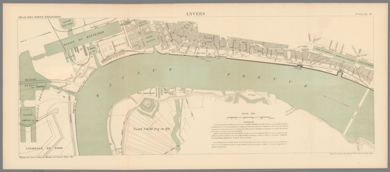
Anvers. 1ère Série. Pl. XII. Direction des Cartes et Plans du Ministère des Travaux Publics. 1883. Gravé et imprimé chez Becquet Fres. et A. Simon. 37, R. des Noyers.
List No
14306.018
Note
Map showing the port of Antwerp, Belgium, in 1883. Features streets, bridges, drainage and docks. Includes a bar scale and compass rose, with north oriented toward top-left of sheet. Descriptive text throughout. Lithograph in black, white and green. Map is 27 x 70 cm, on fold-out sheet 33 x 76 cm. Bookplate title pasted to verso: Pl. XII. 1re série. Anvers. Appears in Première livraison.
Author
[France. Ministère des travaux publics. Administration des routes, France. Direction des cartes, plans et archives et de la statistique graphique, École nationale des ponts et chaussées (France)]
Full Title
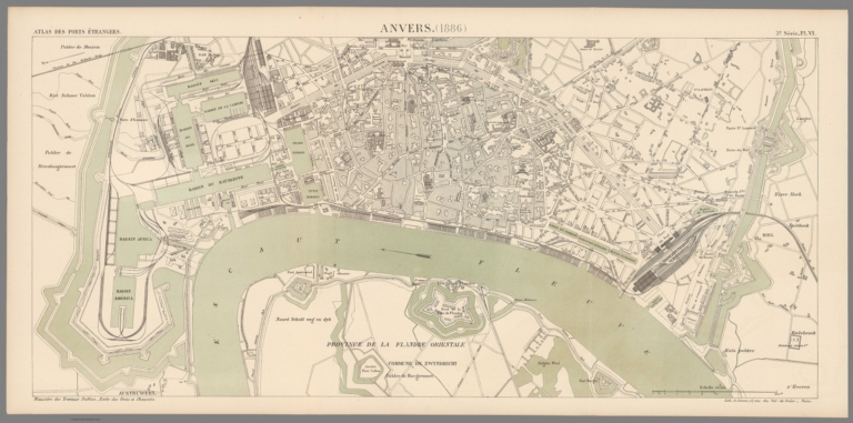
Anvers. (1886). 3e Série. Pl. VI. Ministère des Travaux Publics. Ecole des Ponts et Chaussées. Lith. A. Simon, 13, R. du Val-de-Grâce. Paris.
List No
14306.068
Note
Map showing the port of Antwerp, Belgium, in 1886. Features railways, streets, bridges, drainage and docks. Includes a bar scale and compass rose, with north oriented toward left of sheet. Descriptive text throughout. Lithograph in black, white and green. Map is 29 x 64 cm, on fold-out sheet 33 x 68 cm. Bookplate title pasted to verso: Pl. VI. Anvers. Appears in Troisième livraison.
Author
Imhof, Eduard, 1895-1986
Full Title
Antwerpen -- Scheldemündung.
List No
14401.039
Note
Two maps of the Netherlands and Belgium, featuring Antwerp (Belgium) and the Scheldt River (Netherlands and Belgium), in 1969. Maps show cities, railways, roads, topography, vegetation, bodies of water, drainage, coastlines, islands and water depths. Relief shown with shading and spot heights. Maps include latitudinal and longitudinal lines, legends, bar scales and scale statements (scales differ). Colored lithograph. Together, maps are 29 x 17 cm, on sheet 33 x 22 cm. Maps appear in section entitled Niederlande und Belgien [= Netherlands and Belgium].
Author
[Meyer, Joseph, 1796-1856, Society for the Diffusion of Useful Knowledge (Great Britain)]
Full Title
Antwerpen. Plan topographique d'Anvers, 1845. Aus der Geographischen Graviranstalt des Bibliographischen Instituts zu Hildburghausen, Amsterdam, Paris u. Philadelphia, (1860)
List No
4807.077
Note
Engraved map. Inset map: Plan der Schelde & der forts von Antwerpen bis Lillo. Includes view. Based on the the 1832 map of the Society for the Diffusion of Useful Knowledge, London. "Meyers Handatlas No. 77."
1-5 of 5
|