|
Author
Andriveau-Goujon, Eugene
Full Title
(Composite Map) Algerie, d'apres les cartes de l'Etat-major et les documents du Ministere de la Guerre. E. Andriveau-Goujon, Editeur. Paris, Rue du Bac. 21.1862. Paris, Impie. de Louis Antoine. Gravee par Ms. Gerin, Dalmont, Smith et Fontaine. (to accompany) Atlas classique et universel de geograparphie ancienne et moderne ... Nouvelle edition. 1863.
List No
13421.057
Note
Composite map of sheets 43-44: Algerie.
Author
Impr. Kappelin
Full Title
Province De Constantine (Feuille 1ere.)
List No
15655.002
Author
Impr. Kappelin
Full Title
Province De Constantine (Feuille 2e..)
List No
15655.003
Author
Impr. Kappelin
Full Title
(Composite map to) Province De Constantine (Feuilles 1ere.& 2 e.)
List No
15655.004
Author
Andriveau-Goujon, E. (Eugène), 1832-1897
Full Title
(20) Algérie d'après les cartes de l'état-major et les documents du Ministère de la Guerre. E. Andriveau-Goujon, éditeur. Paris, Rue du Bac, 4, 1880. Paris, Impie. Alfred Chardon jeune; Gravée par Ms. Gérin; Dalmont, Smith et Fontaine.
List No
14008.024
Note
Hand-colored, engraved map of Algeria and greater North Africa, showing showing political boundaries, roads, railroads, water routes and military divisions (on double plate with decorative border). Includes legend, as well as 2 bar scales and a scale statement. "No. 21" in upper right. "Atlas usuel, No. 28" and "Atlas universel, No. 41" in lower right. With inset (indexed to show colonies): Carte d'Ensemble des rapports entre la France, l'Algérie, la Sénégambie et le Nord de l'Afrique.
Author
[Pelet, Paul, 1849-1927, Challamel, Augustin, 1818-1894, Hausermann, R., active 1875-1915]
Full Title
Allgérie et Tunisie. Nouvel atlas des colonies Françaises par Paul Pelet, 1891, No 3-5. A. Challamel, Éditeur, 5 rue Jacob, Paris. Gravé par R. Hausermann, Paris, Imp. Lemercier et Cie.
List No
14300.018
Note
Map of Algeria and Tunisia, including the vicinity. Shows place names, transportation routes, topography, lakes, drainage, islands and water depths. Relief shown with shading. Includes latitudinal and longitudinal lines and a legend, as well as a bar scale and a scale statement. Colored lithograph. Map is 35 x 66 cm, on sheet 50 x 72 cm, folded to 25 x 17 cm. Accompanied by descriptive text of the same title, on preceding pages in section III, IV, V. In second part of atlas, Afrique.
Author
Mager, Henri
Full Title
No. 12. Colonied Francaises.
List No
15537.014
Note
Date estimated.
Author
Lapie, Pierre M., 1779-1850
Full Title
Carte comparée des Régences d'Alger et de Tunis.
List No
15515.002
Author
[Ptolemy, Claudius, Mercator, Gerhard, 1512-1594, Pirckheimer, Willibald, Mylius, Arnold]
Full Title
AFR: II. TAB
List No
10991.182
Note
Hand colored outline map of North Africa. Showing landmarks, major cities and towns, rivers and parks. Relief shown pictorially.
Author
Ad. Mertens
Full Title
Algérie (Afrique) Province d'Oran. Imp. Ad. Mertens, Paris-Bruxelles.
List No
14304.084
Note
Map of the French colony in Africa, which is the current-day province of Oran (Algeria). Map shows political boundaries, cities, routes, topography, coastline and drainage. Relief shown with hachures. Map appears as an inset within illustrated scenery from the corresponding area, including indigenous figures in traditional dress, the terrain, flora, fauna, architecture and items of cultural significance, such as regional products. Colored chromolithograph on card, with gilded details. Part of a set of 88 cards showing departments of France, as well as French colonies around the world. Verso of each card has an identical advertisement, beginning: Le fil géographique, 40 millions de pelotes par an très lisse, très fort, aussi brillant que la soie ... [= Geographical thread, 40 million spools per year, very smooth, very strong, as shiny as silk ... ]. (Imprint taken from verso; date estimated.)
Author
[Chatelain Henri, 1684-1743, Gueudeville, Nicolas]
Full Title
Vue de Tunis et d'Alger & de Gigeri : avec quelques particularitez touchant les moeurs de leurs habitants & de quelques autres peuples de Barbarie. Tom. VI. No. 10. Pag. 40. (to accompany) Atlas Historique ... Tome VI. A Amsterdam, chez L'Honore & Chatelain Libraires. M DCC XIX (1719).
List No
13272.642
Note
Engraved views depicting people and customs in Algeria and views of Gigery, Tripoli and Tunisia. Includes descriptive text in the center.
Author
Chapin, Jr., R.M.
Full Title
Algeria. TIME map by R.M. Chapin, Jr. For report documenting above map see Time, November 23, 1942 issue.
List No
11773.000
Note
Color map. "Enlargement of original map drawn for TIME The weekly magazine.". R.M. Chapin Jr. was a prominent Cold War cartographer who worked for Time Magazine. Relief shown by shading.
Author
[Berghaus, Heinrich, Berghaus, Hermann, Schmidt, C., Risch, M.]
Full Title
Tieflander. Entw. v. Herm. Berghaus 1883, Ausg. 1887. Gez. v. C. Schmidt u. M. Risch. Gotha: Justus Perthes. (On upper margin) I. Abt. Geologie No. II. Berghaus' physikal atlas No. 2. (to Accompany) Berghaus' Physikalischer Atlas. (Begrundet 1836 durch Heinrich Berghaus) ... Gotha: Justus Perthes. 1892.
List No
4391.013
Note
14 color lithograph maps with insets on 1 sheet. Includes: Die Heutigen Niederlande, with insets: Niederlande in 1. Jahrhundert -- Niederlande in X. Jahrhundert, at scale of 1: 6,000,000. Fen District -- El-Ghor oder das Jordan Thal -- Kaspisches Tiefland und Manytsch Niederrung -- Natron-Seen -- El Fajum -- Nordrand der Libyschen Wuste -- Das Todte Thal -- Colorado-Wuste -- Nordrand der Algerischen Sahara -- Goban n. Paulistischke -- Sud-Australische Seen -- Tiefland Asale -- Assal-See. Relief shown by contours and spot heights. Depth shown by gradient tints and soundings. Prime meridian is Greenwich.
Author
Ortelius, Abraham, 1527-1598
Full Title
Barbariae et Biledulgerid, Nova Descriptio. Cum Privilegio.
List No
10000.115
Author
Colton, G.W.
Full Title
Africa. North Western Sheet. (Inset) Liberia. Published By G. W & C. B. Colton & Co. No. 172 William St. New York.
List No
0152.106
Note
Prime meridians are Greenwich and Washington D. C.
Author
[Bowen, Emanuel, Gibson, John]
Full Title
Barbary. (to accompany) Atlas Minimus or a New Set of Pocket Maps of the Several Empires, Kingdoms and States of the Known World, with Historical Extracts relative to each. Drawn and Engraved by J. Gibson from the Best Authorities, Revis'd, Corrected and Improv'd by Eman: Bowen Geographer to His Majesty.
List No
0300.040
Note
First edition. The "Historical Extracts" are short bits of text printed on the maps giving relevant geographical information. A revised edition was published in London in 1792. In 1759, another edition was published adding separate geographical descriptions and correcting some of the maps (see our copy). The Philadelphia 1798 edition by Mathew Carey incorporates the 1759 edition text word for word (excepting the maps of United States which Carey omits in favor of his pocket atlas of the U.S.). Gibson and Bowen made the four sheet map of North America (Stevens 49), and Gibson made the four sheet map of America (Stevens 3).
Author
Larousse
Full Title
(Text Page) Algerie.
List No
0418.088
Author
Larousse
Full Title
(Text Page) Algerie.
List No
0418.089
Author
Larousse
Full Title
(Text Page) Algerie.
List No
0418.090
Author
Larousse
Full Title
(Text Page) Algerie.
List No
0418.091
Author
Larousse
Full Title
(Text Page) Algerie.
List No
0418.092
Author
Larousse
Full Title
Algerie et Tunisie.
List No
0418.093
Full Title
Cotes de Barbarie ou les royaumes de Maroc, de Fez, d'Alger, de Tunis et de Tripoli. Avec privilege. (A Paris, chez Delamarche, Geogr., ca. 1800)
List No
0421.022
Note
Engraved map. Outline hand coloring. Relief shown pictorially. Prime meridian: Ferro.
Author
Levasseur, Victor.
Full Title
Algeria Colonie Francaise. Atlas National Illustre. Region Du Sud, No. 87. Geographie et Statistique par V. Levasseur, Ingr. Geographe, Rue de Malte, 24. Illustre par A.M. Perrot, attache au Genie et Raimond Bonheur, peintre. Grave par Laguillermie et Rainaud, Rue St. Jacques, 82. A Paris, chez Combette, Editeur, Rue de la Parcheminerie, 15. Impie. De Lemercie, rue de Seine, 57 - Paris. (1856)
List No
0427.087
Note
Margin illustrations lavish and of excellent quality showing local heros, products, landscapes, and dress. Major relief shown with hachures. District boundaries, roads, towns and cities shown. Color along boundaries. Rivers shown. Text shows local statistics, map legend, and discusses land, curiosities, personages, products, and commerce. Steel engraving.
Author
Levasseur, Victor.
Full Title
Isle De La Reunion, Colonie Francaise (Ocean indien). Atlas National Illustre. Emisphere Austral., No. 88. Geographie et Statistique par V. Levasseur, Ingr. Geographe. La Geographie Gravee par A. Piat. Impie. De Lemercie, rue de Seine, 57 - Paris. A Paris, chez L'Editeur, Rue de la Parcheminerie, 15. (1856)
List No
0427.088
Note
Margin illustrations lavish and of excellent quality showing local heros, products, landscapes, and dress. Forests and dunes shown by stippling. District boundaries, roads, towns and cities shown. Color along boundaries. Rivers shown. Text shows local statistics, map legend, and discusses land, curiosities, personages, products, and commerce. Steel engraving.
Author
Malte-Brun, Conrad, 1775-1826
Full Title
Barbarie, 1834. No. 57. Grave par Thierry.
List No
0458.058
Note
Engraved map. Countries trimmed in color. Rivers, lakes, roads, and islands shown. Major relief shown by hachures. Includes 5 scales.
Author
[Martin, R.M., Tallis, J. & F.]
Full Title
Northern Africa. The Illustrations by H. Winkles & Engraved by G. Greatbach. The Map Drawn & Engraved by J. Rapkin.
List No
0466.063
Note
In outline color with illustrations of Marocco, Constantine, Algiers, and Tunis. Decorative border.
Author
[Desbuissons, L.E., Migeon, J.]
Full Title
Algerie et Tunisie. Grave par L. Smith. Dresse Sous La Direction De J. Migeon Par Ch. Lacoste. Migeon, editeur, imp, r. du Moulin Vert, Paris. Ecrit par A. Bizet. (1892). Fillatreau del. and Barbier sc. (for vignette).
List No
0507.057
Note
Full color by state. Relief shown by hachures. Shows sea routes and distances. Vignette of Alger.
Author
Pinkerton, John, 1758-1826
Full Title
Northern Africa. Drawn under the direction of Mr. Pinkerton by L. Hebert. Neele sculpt. 352 Strand. London: published 1st. Jany. 1814 by Cadell & Davies, Strand & Longman, Hurst, Rees, Orme, & Brown, Paternoster Row.
List No
0732.059
Note
Engraved map. Full hand col. Relief shown by hachures. "Pinkerton's modern atlas."
Author
Polish Army Topography Service
Full Title
Algeria - Saharan Landscape (Tassili-N-Ajjer). Pergamon World Atlas. Pergamon Press, Ltd. & P.W.N. Poland 1967. Sluzba Topograficzna W.P.
List No
0737.176
Note
Detailed physical map.
Author
Polish Army Topography Service
Full Title
Morocco, Algeria, Tunisia. Pergamon World Atlas. (inset) El Djezair (Algiers). (inset) Er Ribat (Rabat). Pergamon Press, Ltd. & P.W.N. Poland 1967. Sluzba Topograficzna W.P.
List No
0737.177
Note
Detailed physical and political map.
Author
[Scovel, James L., O'Brien, Emmett J]
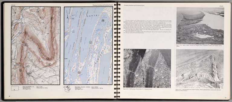
Full Title
Folds. Plunging Anticlines and Synclines-Humid. Hollidysburg, PA. Belcher Islands, Canada. 1:250,000.
List No
0889.022
Note
Two contour maps and three views on two pages, includes text, and outline location map. Views showing Belcher Islands; Hollidaysburg, Pennsylvania; and Sheep Mountain near Greybull, wyoming. Relief shown by contours and spot height.
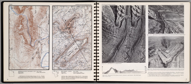
Author
[Scovel, James L., O'Brien, Emmett J]
Full Title
Folds. Plunging Anticlinal and Synclinal Mountain-Arid. Dinosaur National Monument, Utah. Bou Khadra, Algeria. 1:50,000. (on opposite page) Anticlinal and Synclinal Mountain. (with three views).
List No
0889.023
Note
Two contour maps and three views and cross-section on two pages. Includes text, and outline location maps. Two views showing Split Mountin; Sheep Mountain near Grebull; Cross-section A-A' Bou khadra. Relief shown by contours and spot height.
Author
Society for the Diffusion of Useful Knowledge (Great Britain)
Full Title
North-Africa or Barbary II. Algier. Published under the superintendence of the Society for the Diffusion of Useful Knowledge. Engraved by J. & C. Walker. London, published by Baldwin & Cradock, 47 Paternoster Row, Septr. 1st. 1834. (London: Chapman & Hall, 1844)
List No
0890.113
Note
Engraved map. Relief shown by hachures and spot heights. Boundaries and lakes hand col. Includes inset. Sources: Shaw, Smyth, Rozet, Lapie, Garnier and Berard.
Author
[Smith, Philip, 1817-1885, Society for the Diffusion of Useful Knowledge (Great Britain)]
Full Title
Ancient Africa or Libya. Part I. By Philip Smith, Univ. Coll., London. Published under the superintendence of the Society for the Diffusion of Useful Knowledge. J. & C. Walker, sculpt. London, published by Chapman & Hall, 186, Strand, April 18th. 1840. (1844)
List No
0890.117
Note
Engraved map. Relief shown by hachures. Boundaries and lakes hand col. Covers North Africa from Mauritania to Byzancium (Morocco to Tunisia)
Author
Stanford, Edward
Full Title
Morocco, Algeria & Tunis with Parts of Senegal and the Military Territories of the Western Sudan.
List No
0949.088
Note
Full color. Relief shown by hachures and spot heights. Shows settlements, roads, railroads, submarine cables, etc.
Author
[Stieler, Adolf, Domann, B.]
Full Title
69. Afrika in 7 Blaettern, Bl. 1.
List No
0961.152
Author
[Stieler, Adolf, Dormann, B.]
Full Title
Nr. 69. Afrika, Bl. 1. .... B. Dormann.
List No
0962.152
Author
[Ortelius, Abraham, 1527-1598, Vrients, Jan Baptista]
Full Title
Barbariae et Biledulgerid, Nova Descriptio. Cum Privilegio.
List No
10001.323
Author
[Ortelius, Abraham, 1527-1598, Vrients, Jan Baptista]
Full Title
Fessae, Et Marocchi Regna Africae Celeberr. describebat Abrah. Ortelius. 1595. Cum Imp. Reg. & Brabantiae privilegio decennali. (inset) Congi Regni Christiani, In Africa, Nova Descriptio. Auctore Philippo Pigafetta.
List No
10001.325
Author
Blaeu, Joan, 1596-1673
Full Title
Barbaria
List No
10017.595
Note
2 maps on one sheet.
Author
Thomson, John
Full Title
North Africa. South Africa. Engd. by W. Dassauville, Edinr. Drawn and engraved for Thomson's New general atlas, 1815.
List No
1007.054
Note
Two engraved maps on 1 sheet. Hand colored. Relief shown by hachures. Label with "No. 49" affixed to upper left corner.
Author
[Martin, R.M., Tallis, J. & F.]
Full Title
Northern Africa. The Illustrations by H. Winkles & Engraved by G. Greatbach. The Map Drawn & Engraved by J. Rapkin.
List No
10095.064
Note
In outline color with illustrations of Marocco, Constantine, Algiers, and Tunis. Decorative border.
Full Title
Africa, north-west. (with) Cape Verd Islands. (Published at the office of "The Times," London, 1895)
List No
1010.071
Note
Color map with inset. Relief shown by hachures and spot heights. Shows settlements, tribes, European colonial boundaries, etc.
Author
Pirî Reis, d. 1554?
Full Title
fol. 267b Moroccan and Algerian coastline from Melilla northwest of Tlemcen
List No
10108.544
Note
Author's name given on fol. 376b as Raʾīs al-Baḥr Pīrī ibn Muḥammad; author dates preferred by (Walters) cataloger: d. 962 AH / 1555 CE
Author
Pirî Reis, d. 1554?
Full Title
fol. 268b Algerian coastline around Oran and Mostaganem
List No
10108.546
Note
Author's name given on fol. 376b as Raʾīs al-Baḥr Pīrī ibn Muḥammad; author dates preferred by (Walters) cataloger: d. 962 AH / 1555 CE
Author
Pirî Reis, d. 1554?
Full Title
fol. 269b Algerian coastline around Mostaganem
List No
10108.548
Note
Author's name given on fol. 376b as Raʾīs al-Baḥr Pīrī ibn Muḥammad; author dates preferred by (Walters) cataloger: d. 962 AH / 1555 CE
Author
Pirî Reis, d. 1554?
Full Title
fol. 270b Algerian coastline around Algiers
List No
10108.550
Note
Author's name given on fol. 376b as Raʾīs al-Baḥr Pīrī ibn Muḥammad; author dates preferred by (Walters) cataloger: d. 962 AH / 1555 CE
Author
Pirî Reis, d. 1554?
Full Title
fol. 271b Algerian coastline from Algiers to Bejaia
List No
10108.552
Note
Author's name given on fol. 376b as Raʾīs al-Baḥr Pīrī ibn Muḥammad; author dates preferred by (Walters) cataloger: d. 962 AH / 1555 CE
Author
Pirî Reis, d. 1554?
Full Title
fol. 274b Algerian coastline from the port of Bejaia as far as Annaba with the city of Constantine
List No
10108.558
Note
Author's name given on fol. 376b as Raʾīs al-Baḥr Pīrī ibn Muḥammad; author dates preferred by (Walters) cataloger: d. 962 AH / 1555 CE
|