|
REFINE
Browse All : Images of Africa, Southern and South Africa
1-37 of 37
Author
Arrowsmith, John
Full Title
Cape of Good Hope, by J. Arrowsmith. London, pubd. 15 Feby. 1836 by J. Arrowsmith, 35 Essex Street, Strand.
List No
0036.024
Note
Engraved map. Hand colored boundaries. Relief shown by hachures. Northeastern part on separate sheet, pasted on. "This map is with permission copied from the original M.S. drawing in the Colonial Office, compiled by Mr. Herbert, Senr."
Author
Brue, Adrien Hubert, 1786-1832
Full Title
(Carte detaillee en deux feuilles de l'Afrique et des iles qui en dependent). Afrique meridionale (par A. Brue, Geographe du Roi ... Paris, 1828). (with) Extremite sud de l'Afrique ou Colonie du cap, pays des Hottentots et des Betjouanas. (with) Archipel du nord-est de Madagascar. (Chez l'Auteur, rue des Macons-Sorbonne, no. 9, et chez les principaux marchands de cartes geographiques)
List No
0096.053
Note
Hand colored engraved map. Relief shown by hachures. Also includes insets of Ascension, Tristan de Acuna and Diego Aloarez, Bouvet, Crozet, Amsterdam and Saint Paul, Kerguelen, and Isles Mascareignes. Prime meridian: Paris.
Author
Brue, Adrien Hubert, 1786-1832
Full Title
(Composite of) Carte detaillee en deux feuilles de l'Afrique et des iles qui en dependent ... par A. Brue, Geographe du Roi ... Paris, 1828. (with) Abyssinie et pays des Gallas. (with) Extremite sud de l'Afrique ou Colonie du cap, pays des Hottentots et des Betjouanas. (with) Archipel du nord-est de Madagascar. Chez l'Auteur, rue des Macons-Sorbonne, no. 9, et chez les principaux marchands de cartes geographiques.
List No
0096.054
Note
Digital composite of 2 hand colored engraved maps (north and south sheet). Relief shown by hachures. Includes inset of Cape Verde, Ascension, Tristan de Acuna and Diego Aloarez, Bouvet, Crozet, Amsterdam and Saint Paul, Kerguelen, and Isles Mascareignes. Prime meridian: Paris.
Author
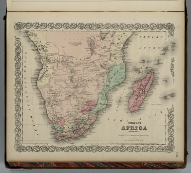
Colton, G.W.
Full Title
Colton's Africa Southern Sheet. Published By G. W & C. B. Colton & Co. No. 172 William St. New York.
List No
0152.107
Note
Prime meridians are Greenwich and Washington D. C.
Author
Cornell, S. S. (Sarah S.)
Full Title
Africa. Designed to accompany Cornell's High school geography. (with) Map of Isthmus of Suez. (with) Liberia. (with) Southern part of Africa. Entered ... 1855, by S.S. Cornell ... Southern District of New York. New York: D. Appleton & Co., 443 & 445 Broadway. (1864)
List No
0197.025
Note
Engraved map with 3 insets. Hand colored. Relief shown by hachures. Prime meridians: Greenwich and Washington.
Author
Johnston, Alexander Keith, 1804-1871
Full Title
North-western Africa, comprising Marocco, Algeria & Tunis ... Southern Africa, comprising Cape Colony, Natal, &c. By Keith Johnston, F.R.S.E. Engraved & printed by W. & A.K. Johnston, Edinburgh. William Blackwood & Sons, Edinburgh & London, (1861)
List No
0373.043
Note
Two engraved maps on 1 sheet. Boundaries hand col.; hydrography printed in blue. Relief shown by hachures and spot heights. Scales: North-western Africa 1:4,522,426, Southern Africa 1:3,651,858. "Keith Johnston's general atlas 38."
Author
Thomson, John
Full Title
North Africa. South Africa. Engd. by W. Dassauville, Edinr. Drawn and engraved for Thomson's New general atlas, 1815.
List No
1007.054
Note
Two engraved maps on 1 sheet. Hand colored. Relief shown by hachures. Label with "No. 49" affixed to upper left corner.
Full Title
South Africa. (Published at the office of "The Times," London, 1895)
List No
1010.069
Note
Color map with inset. Relief shown by hachures and spot heights. Show settlements, railroads, telegraph lines, etc.
Author
[Touring club italiano, Funk & Wagnalls Company.]
Full Title
Colonia del Capo, Cape of Good Hope. Propr. Artistico-letteraria del T.C.I. Ufficio cartografico del T.C.I. (1929)
List No
1012.064
Note
Color map. Relief shown by hachures and spot heights; depths by isolines. Includes insets at 1:250,000 and 1:1,500,000 scale of the Cape Town region.
Author
[Touring club italiano, Funk & Wagnalls Company.]
Full Title
(Legend to) Colonia del Capo. America Settentrionale fisica. Propr. Artistico-letteraria del T.C.I. Ufficio cartografico del T.C.I. (1929)
List No
1012CJ
Note
Explanation to maps (2 facing sheets)
Author
[Sohr, Karl, Berghaus, Heinrich, 1797-1884, Handtke, Friedrich, 1815-1879, Klein, H.J.]
Full Title
Sudliches Afrika. Blatt IV. Druck und Verlag von C. Flemming in Glogau. (to accompany) Sohr-Berghaus Hand-Atlas uber alle Theile der Erde. Neu bearbeitet von F. Handtke, Achte vermehrte und verbesserte Auflage. No. 85. (inset) Togo-Gebiet und Sklavenkuste.
List No
11640.093
Note
Outline color lithograph engraving double page map of Southern Africa, color coded by European possessions. Relief shown by hachures. Prime meridians are Greenwich, Paris and Ferro.
Author
[Arrowsmith, John, 1790-1873, Stanford, Edward, 1827-1904]
Full Title
South Africa. London: Published 1st. Octr. 1884, by Edward Stanford, 55 Charing Cross. Engraved at Stanfors Geographical Establishment, London. (to accompany) Stanford's London Atlas Of Universal Geography. Folio edition.
List No
11741.045
Note
Outline hand color folded map. Showing political and administrative divisions, cities, towns, railroads, roads, military posts and forts, missionary stations, canals, mountains and rivers. Relief shown by hachures. Prime meridian is Greenwich. Includes legend, reference and abbreviations.
Author
[Wyld, James, 1812-1887, Wyld, James, 1790-1836]
Full Title
Cape District : Cape of Good Hope. London. Published by James Wyld. 1838. (to accompany) A new general atlas of modern geography : consisting of a complete collection of maps of the four quarters of the globe ...
List No
13170.052
Note
Engraved map, hand colored in outline, with decorative title cartouche. Scale in Dutch and British miles, nautical leagues.Shows major cities and towns. Relief shown pictorially and by hachures.
Author
Habenicht, Hermann
Full Title
Justus Perthes (10 Blatt) Sektion Capland (9). Bearbeitet v. Dr. Rich. Luddecke. (to accompany) Spezial-Karte von Afrika ... Entworfen von Hermann Habenicht ... Justus Perthes in Gotha September 1885.
List No
13218.035
Note
Color map. Relief shown by shading, hachures and spot heights. Prime meridian is Greenwich.
Author
[3, Soviet Union. Glavnoe upravlenie geodezii i kartografii]
Full Title
Южная Африка = IUzhnaia Afrika. 206-207. Atlas Mira : 1954.
List No
13682.220
Note
Political and physical map of South Africa and islands of Mascarene. Relief shown by gradient tints and spot heights. Depths shown by gradient tints, isolines and soundings.
Author
[3, Soviet Union. Glavnoe upravlenie geodezii i kartografii]
Full Title
Южно-Африканский Союз (Восток). Южно-Африканский Союз (Юг) = IUzhno-Afrikanskiy Soiuz (Vostok). IUzhno-Afrikanskiy Soiuz (Iug). 208. Atlas Mira : 1954.
List No
13682.221
Note
2 maps on 1 sheet. Relief shown by gradient tints and spot heights. Depths shown by gradient tints, isolines and soundings.
Author
Cram, George Franklin, 1841-1928
Full Title
South Africa, Cape Colony, Natal, Orange Free State and South African Republic.
List No
14372.350
Note
Map of Southern Africa, including South Africa. Shows political boundaries, cities, railroads, submarine telegraph lines, topography, deserts, bodies of water, drainage, coastlines, islands and water routes with distances. Relief shown with hachures and peak heights. Includes latitudinal and longitudinal lines, as well as a bar scale given in miles and explanatory notes throughout. Provides figures for square milage and population. Map indexed to indicate place names. olored lithograph. Map is 23 x 31 cm, on sheet 45 x 33 cm.
Full Title
Senegambien. Goldkuste und Kapland: Goldkuste u. Niger Delta, Sud-Afrika. (Richard Andree. Herausgegeben von der Geographischen Anstalt von Velhagen & Klasing in Leipzig. 1881)
List No
1494.072
Note
Three colored maps on 1 sheet. Relief shown by hachures and spot heights. Show settlements, tribes, colonial boundaries, railroads, roads, rivers, missions, etc. Sud-Afrika map at 1:13,250,000 scale.
Author
Colton, G.W.
Full Title
Colton's Africa, Southern Sheet. Published By G. W & C. B. Colton & Co., No. 182 William St. New York.
List No
1550.105
Note
Prime meridians are Greenwich and Washington D. C.
Author
[Fullback Academy, Peterson, Augusts]
Full Title
South Africa. (Moravia Church establishments). Lithe. by A. Peterson, 9, Charing Cross. (1853)
List No
1868.011
Note
Color lithographed map. Shows Moravia stations with founding dates. Relief shown by hachures.
Author
Fullback Academy
Full Title
South Africa (compiled from the most recent and authentic sources, by the teachers of the Fullback Academy, 1853)
List No
1868Y
Note
Two columns of text.
Author
Fullback Academy
Full Title
(South Africa compiled from the most recent and authentic sources, by the teachers of the Fullback Academy, 1853)
List No
1868ZA
Note
Continuation.
Author
Tanner, Henry Schenck
Full Title
Cape of Good Hope. (to accompany) Atlas Modern. (The Cyclopedia; or, Universal Dictionary of Arts, Sciences, and Literature. 41 vol, 6 vol. of Plates, Ancient and modern atlas.)
List No
2076.036
Note
Engraved double page map. Shows boundaries and division, coastal detail, major cities rivers and mountains. Prime meridian is Greenwich. Relief shown by hachures.
Author
[Geographisches Institut (Weimar, Germany), Kiepert, Heinrich, 1818-1899, Weiland, Carl Ferdinand, 1782 -1847]
Full Title
Die Sudspitze von Africa mit der Colonie am Vorgebirge der guten Hoffnung und dem Kaffern-Lande. (with) Die Halbinsel am Vorgebirge der guten Hoffnung nach Owen u. Vidal. Nach C.F. Weilands, Entwurf, berichtigt von H. Kiepert. Weimar, im Verlage des geograph. Instituts, 1854.
List No
2077.058
Note
Engraved map. Outline hand col. Relief shown by hachures and spot heights. Prime meridians: Paris and Ferro.
Author
[Bartholomew, J. G. (John George), 1860-1920, John Bartholomew and Son]
Full Title
Cape Province, Transvaal, &c. - western section. (with) Cape Town. (with Cape Town Region). The Edinburgh Geographical Institute, John Bartholomew & Son, Ltd. "The Times" atlas. (London: The Times, 1922)
List No
2113.082
Note
Col. map. Relief shown by hypsometric tints and spot heights; depths by bathymetric tints. Shows shipping routes with distances, etc. Scale of insets: Cape Town 1:42,240, Cape Town Region (ca. 1:181,000)
Author
[Bartholomew, J. G. (John George), 1860-1920, John Bartholomew and Son]
Full Title
Cape Province, Transvaal, &c. - eastern section. (with) Port Elizabeth. (with) Durban. The Edinburgh Geographical Institute, John Bartholomew & Son, Ltd. "The Times" atlas. (London: The Times, 1922)
List No
2113.083
Note
Col. map. Relief shown by hypsometric tints and spot heights; depths by bathymetric tints. Shows shipping routes with distances, etc. Scale of insets 1:42,240.
Author
[Bartholomew, J. G. (John George), 1860-1920, John Bartholomew and Son]
Full Title
(Composite of) Cape Province, Transvaal, &c. The Edinburgh Geographical Institute, John Bartholomew & Son, Ltd. "The Times" atlas. (London: The Times, 1922)
List No
2113.084
Note
Composite of 2 col. maps. Relief shown by hypsometric tints and spot heights; depths by bathymetric tints. Shows shipping routes with distances, etc. Includes insets.
Author
Vandermaelen, Philippe, 1795-1869
Full Title
Partie de la Caffrerie. Afrique no. 52. (Dresse par Ph. Vandermaelen, lithographie par H. Ode. Troisieme partie. - Afrique. Bruxelles. 1827)
List No
2212.198
Note
Hand col. lithographed map. Relief shown by pictorially. Prime meridian: Paris. Covers parts of Mozambique, South Africa and Swaziland. Includes text: Note sur la Caffrerie.
Author
[Geographisches Institut (Weimar, Germany), Graf, Adolf]
Full Title
Sud Africa. Bearbeitet von Adolf Graf. Terrain v. G. Dietrich. Gest. v. G. Haubold. Weimar: Geographisches Institut. (to accompany) Hand - Atlas Der Erde Und Des Himmels.
List No
2595.062
Note
Outline hand color map. Color coded by European possessions. Shows the routes followed by the principal explorers from 1831 to 1862. Also shows cities, towns, roads, rivers, etc. Includes legend and notes. Relief shown by hachures. Prime meridians are Greenwich and Paris.
Author
[Brue, Adrien Hubert, 1786-1832, Picquet, C.]
Full Title
(Carte detaillee en deux feuilles de l'Afrique et des iles qui en dependent) Afrique meridionale (par A. Brue, Geographe du Roi ... Paris, 1828). (with) Extremite sud de l'Afrique ou Colonie du Cap, pays des Hottentots et des Betjouanas. (with) Archipel du nord-est de Madagascar. (Chez Chles. Picquet, Quai Conti No. 17, pres du Pont des Arts. Revue en 1834)
List No
2741.053
Note
Hand colored engraved map. Relief shown by hachures. Also includes insets of Ascension, Tristan de Acuna and Diego Aloarez, Bouvet, Crozet, Amsterdam and Saint Paul, Kerguelen, and Isles Mascareignes. Prime meridian: Paris. In embossed seal: Propriete acquise en 1835.
Author
[Brue, Adrien Hubert, 1786-1832, Picquet, C.]
Full Title
(Composite of) Carte detaillee en deux feuilles de l'Afrique et des iles qui en dependent par A. Brue, Geographe du Roi ... Paris, 1828. (with) Abyssinie et pays des Gallas. (with) Extremite sud de l'Afrique ou Colonie du Cap, pays des Hottentots et des Betjouanas. (with) Archipel du nord-est de Madagascar. Chez Chles. Picquet, Quai Conti No. 17, pres du Pont des Arts. Revue en 1834.
List No
2741.054
Note
Digital composite of 2 hand colored engraved maps (north and south sheets). Relief shown by hachures. Includes inset of Cape Verde, Ascension, Tristan de Acuna and Diego Aloarez, Bouvet, Crozet, Amsterdam and Saint Paul, Kerguelen, and Isles Mascareignes. Prime meridian: Paris. In embossed seal: Propriete acquise en 1835.
Author
Rand McNally and Company
Full Title
Rand, McNally & Company's indexed atlas of the world map of South Africa. Copyright 1892, by Rand, McNally & Co. (Chicago, 1897)
List No
3565.036
Note
Col. map. Relief shown by hachures. Title in margin: Rand, McNally & Company's indexed atlas of the world.
Author
Hall, S. (Sidney)
Full Title
Southern Africa. By Sidney Hall. London, published by Longman, Rees, Orme, Brown & Green, Paternoster Row, Octr. 1st. 1828.
List No
4224.041
Note
Engraved map. Boundaries hand col. Relief shown by hachures. Also numbered XL.
Author
Flemming, Carl
Full Title
Sud-Africa. (with Umgebung von Cap Stadt). (with) Cap Stadt. Druck u. Verlag von C. Flemming in Glogau. (1855)
List No
4765.088
Note
Hand colored lithographed map. Relief shown by hachures. Prime meridian: Paris.
Author
Radefeld, Carl Christian Franz, 1788-1874
Full Title
Neueste Karte von Sudafrica. Nach den besten Quellen entworf. u. gezichn. v. Hauptm. Radefeld. 1846. Aus der Geograph. Graviranstalt des Bibliographischen Instituts zu Hildburghsn., Amsterdam, Paris u. Philadelphia, (1860)
List No
4807.122
Note
Engraved map. Boundaries hand col. Relief shown by hachures. Inset maps: (Grahamtown und Umgebung) -- District von George -- (Cap Stadt und Umgebung) -- Capstadt. Scale of Capstadt inset (ca. 1:28,880). "Meyer's Handatlas No. 93." Prime meridians: Ferro, Paris and Greenwich. David Rumsey Collection copy has annotations in pen-and-ink.
Author
[Edward Stanford Ltd., Stanford, Edward]
Full Title
South Africa. London atlas series. Stanford's Geogl. Estabt., London. London : Edward Stanford, 12, 13 & 14, Long Acre, W.C. (1901)
List No
5075.079
Note
Full color. Relief shown by hachures and spot heights. Shows settlements, military posts and forts, missionary stations, roads, railroads, submarine cables, etc.
Author
Letts, Son & Co.
Full Title
South Africa. (with) Environs of the Cape. (with) Cape-Town. Letts's popular atlas. Letts, Son & Co. Limited, London. (1883)
List No
5371.106
Note
Colored map. Relief shown by hachures. Shows cities, gold fields, diamond fields, wool growing districts, lights and lighthouses, railroads, rivers, etc. Includes statistical tables.
1-37 of 37
|