|
Author
Mercier, Jacques
Full Title
Australie
List No
15949.001
Note
Date estimated from newspaper text on verso.
Author
[United States. Army Service Forces. Army Information Branch., Harrison, Richard Edes]
Full Title
Newsmap For the Armed Forces. 276th Week of the War - 158th Week of U.S. Participation.
List No
15947.001
Note
Duplicate of 9014.000 but with mailing envelope added.
Author
United States. Army Service Forces. Army Information Branch.
Full Title
South Burma and Thailand. Prepared In The R and A Branch OSS.
List No
15947.002
Note
Duplicate of 9014.000 but with mailing envelope added.
Author
[United States. Army Service Forces. Army Information Branch., Harrison, Richard Edes]
Full Title
(Covers to) NEWSMAP Monday, 25 December, 1944
List No
15947.003
Note
Duplicate of 9014.000 but with mailing envelope added.
Author
News Map of the Week, Inc.
Full Title
World News of the Week : Monday, Apr. 10, 1944. Covering period Mar. 31 to Apr. 6. Volume 6, No. 32. Published and copyrighted (weekly), 1944, by News Map of the Week, Inc., 1512 Orleans Street, Chicago, Illinois. Published in two sections : Section one. Lithographed in U. S. A.
List No
14167.000
Note
Lithographed world map, in color. Shows political boundaries and military events of World War II, from March 31 to April 6, 1944. Relief illustrated with hachures. Includes a key indicating the alignment of warring nations (United, Axis, and neutral). Descriptive text throughout, e.g.: Budapest bombed by Allied planes. Map indexed according to historical notes beneath map. Features photographs, illustrations, and international time zones. With two inset maps: Reference chart for Pan-American Day, April 14, 1944 -- The Russian battlefront. Map is 56 x 115 cm, on sheet 89 x 120 cm, folded to 31 x 23 cm.
Author
News Map of the Week, Inc.
Full Title
World News of the Week : Monday, Apr. 24, 1944. Covering period Apr. 14 to Apr. 20. Volume 6, No. 34. Published and copyrighted (weekly), 1944, by News Map of the Week, Inc., 1512 Orleans Street, Chicago, Illinois. Published in two sections : Section one. Lithographed in U. S. A.
List No
14168.000
Note
Lithographed world map, in color. Shows political boundaries and military events of World War II, from April 14 to 20, 1944. Relief illustrated with hachures. Descriptive text throughout, e.g.: Where tornado struck. Map indexed according to historical notes beneath map. Features photographs, illustrations, and international time zones. With three inset maps: (Japanese advance in India) -- The size of the United States -- The Army's global airways. Map is 56 x 115 cm, on sheet 89 x 120 cm, folded to 31 x 23 cm.
Author
News Map of the Week, Inc.
Full Title
World News of the Week : Monday, May 8, 1944. Covering period Apr. 28 to May 4. Volume 6, No. 36. Published and copyrighted (weekly), 1944, by News Map of the Week, Inc., 1512 Orleans Street, Chicago, Illinois. Published in two sections : Section one. Lithographed in U. S. A.
List No
14170.000
Note
Lithographed world map, in color. Shows political boundaries and military events of World War II, from April 28 to May 4, 1944. Relief illustrated with hachures. Descriptive text throughout, e.g.: Ft. Norman - Whitehorse oil pipeline opened. Map indexed according to historical notes beneath map. Features photographs, illustrations, and international time zones. With inset map: (European communication networks). Also, with two diagrams: (Photo flash bomb) -- Bombing tons dropped on Axis Europe. Map is 56 x 115 cm, on sheet 89 x 120 cm, folded to 31 x 23 cm.
Author
News Map of the Week, Inc.
Full Title
World News of the Week : Monday, Mar. 13, 1944. Covering period Mar. 3 to Mar. 9. Volume 6, No. 28. Published and copyrighted (weekly), 1944, by News Map of the Week, Inc., 1512 Orleans Street, Chicago, Illinois. Published in two sections : Section one. Lithographed in U. S. A.
List No
14171.000
Note
Lithographed world map, in color. Shows political boundaries and military events of World War II, from March 3 to 9, 1944. Relief illustrated with hachures. Includes a key indicating the alignment of warring nations (United, Axis, and neutral). Descriptive text throughout, e.g.: Reds cut main Nazi supply line. Map indexed according to historical notes beneath map. Features photographs, illustrations, and international time zones. With two inset maps: (South America) -- (Berlin). Also, with diagram: The income tax and federal revenue. Map is 56 x 115 cm, on sheet 89 x 120 cm, folded to 31 x 23 cm.
Author
News Map of the Week, Inc.
Full Title
World News of the Week : Monday, May 15, 1944. Covering period May 5 to May 11. Volume 6, No. 37. Published and copyrighted (weekly), 1944, by News Map of the Week, Inc., 1512 Orleans Street, Chicago, Illinois. Published in two sections : Section one. Lithographed in U. S. A.
List No
14172.000
Note
Lithographed world map, in color. Shows political boundaries and military events of World War II, from May 5 to 11, 1944. Relief illustrated with hachures. Includes a key indicating the alignment of warring nations (United, Axis, and neutral). Descriptive text throughout, e.g.: Nazis note Anzio activities; flood Pontine Marshes. Map indexed according to historical notes beneath map. Features photographs, illustrations, and international time zones. With four inset maps: (Where Allies concentrate bombers in Europe) -- (Pontine Marshes) -- (China) -- Great Britain and Land-Lease in reverse. Map is 56 x 115 cm, on sheet 89 x 120 cm, folded to 31 x 23 cm.
Author
[Harrison, Richard Edes, Industrial Services Division, Bureau of Public Relations, War Department]
Full Title
Newsmap : Monday, November 29, 1943. Week of November 18 to November 25, 220th week of the War - 102th week of U. S. participation. Volume II No. 32. Basemap drawn by Richard Edes Harrison, © Time Inc. 1940. Distributed by Industrial Services Division, Bureau of Public Relations, War Department. Prepared from public sources of information. U. S. Government Printing Office: 1943.
List No
14188.000
Note
Lithographed world map, in black, gray, blue and white. Shows political boundaries and represents military events of World War II, from November 18 to 25, 1943. Relief illustrated with hachures. Includes a distance table: Tokio to ... Accompanying historical notes describe the war fronts: USSR -- New Guinea -- Gilbert and Marshall Islands -- Bougainville -- Air offensive -- Italy. Features photographs. With three inset maps: Berlin -- (Western Hemisphere) -- (Eastern Hemisphere). Map is 85 x 85 cm, on sheet 89 x 120 cm, folded to 31 x 23 cm. Stamp on verso: Received Nov 1 1943 C. E. King.
Author
[京城報 ( Gyeongseong Ilbo), Mitarai, Tatsuo]
Full Title
(Covers to) 圖勢現 [Statistical Charts]
List No
15877.001
Note
Shova 16, September 18. and 23. [1941].
Author
[京城報 ( Gyeongseong Ilbo), Mitarai, Tatsuo]
Full Title
(Text page to) 圖勢現 [Statistical Charts]
List No
15877.002
Note
Shova 16, September 18. and 23. [1941].
Author
[京城報 ( Gyeongseong Ilbo), Mitarai, Tatsuo]
Full Title
(1) 圖勢現 [Statistical Charts]
List No
15877.003
Note
Shova 16, September 18. and 23. [1941].
Author
[京城報 ( Gyeongseong Ilbo), Mitarai, Tatsuo]
Full Title
(2-3) 圖勢現 [Statistical Charts]
List No
15877.004
Note
Shova 16, September 18. and 23. [1941].
Author
[京城報 ( Gyeongseong Ilbo), Mitarai, Tatsuo]
Full Title
(4-5) 圖勢現 [Statistical Charts]
List No
15877.005
Note
Shova 16, September 18. and 23. [1941].
Author
[京城報 ( Gyeongseong Ilbo), Mitarai, Tatsuo]
Full Title
(6-7) 圖勢現 [Statistical Charts]
List No
15877.006
Note
Shova 16, September 18. and 23. [1941].
Author
[京城報 ( Gyeongseong Ilbo), Mitarai, Tatsuo]
Full Title
(8-9) 圖勢現 [Statistical Charts]
List No
15877.007
Note
Shova 16, September 18. and 23. [1941].
Author
[京城報 ( Gyeongseong Ilbo), Mitarai, Tatsuo]
Full Title
(10-11) 圖勢現 [Statistical Charts]
List No
15877.008
Note
Shova 16, September 18. and 23. [1941].
Author
[京城報 ( Gyeongseong Ilbo), Mitarai, Tatsuo]
Full Title
(12-13) 圖勢現 [Statistical Charts]
List No
15877.009
Note
Shova 16, September 18. and 23. [1941].
Author
[京城報 ( Gyeongseong Ilbo), Mitarai, Tatsuo]
Full Title
(14-15) 圖勢現 [Statistical Charts]
List No
15877.010
Note
Shova 16, September 18. and 23. [1941].
Author
[京城報 ( Gyeongseong Ilbo), Mitarai, Tatsuo]
Full Title
(16-17) 圖勢現 [Statistical Charts]
List No
15877.011
Note
Shova 16, September 18. and 23. [1941].
Author
[京城報 ( Gyeongseong Ilbo), Mitarai, Tatsuo]
Full Title
(18-19) 圖勢現 [Statistical Charts]
List No
15877.012
Note
Shova 16, September 18. and 23. [1941].
Author
[京城報 ( Gyeongseong Ilbo), Mitarai, Tatsuo]
Full Title
(20-21) 圖勢現 [Statistical Charts]
List No
15877.013
Note
Shova 16, September 18. and 23. [1941].
Author
[京城報 ( Gyeongseong Ilbo), Mitarai, Tatsuo]
Full Title
(22-23) 圖勢現 [Statistical Charts]
List No
15877.014
Note
Shova 16, September 18. and 23. [1941].
Author
[京城報 ( Gyeongseong Ilbo), Mitarai, Tatsuo]
Full Title
(24-25) 圖勢現 [Statistical Charts]
List No
15877.015
Note
Shova 16, September 18. and 23. [1941].
Author
[京城報 ( Gyeongseong Ilbo), Mitarai, Tatsuo]
Full Title
(26-27) 圖勢現 [Statistical Charts]
List No
15877.016
Note
Shova 16, September 18. and 23. [1941].
Author
[京城報 ( Gyeongseong Ilbo), Mitarai, Tatsuo]
Full Title
(28-29) 圖勢現 [Statistical Charts]
List No
15877.017
Note
Shova 16, September 18. and 23. [1941].
Author
[京城報 ( Gyeongseong Ilbo), Mitarai, Tatsuo]
Full Title
(30-31) 圖勢現 [Statistical Charts]
List No
15877.018
Note
Shova 16, September 18. and 23. [1941].
Author
[京城報 ( Gyeongseong Ilbo), Mitarai, Tatsuo]
Full Title
(32-33) 圖勢現 [Statistical Charts]
List No
15877.019
Note
Shova 16, September 18. and 23. [1941].
Author
Mercier, Jacques
Full Title
Routes De Guerre Du Pole. Jac Mercier. Dessinateur.
List No
15801.001
Note
Date estimated from text.
Author
Mercier, Jacques
Full Title
La Guerre Du Petrole. Jac Mercier. Dessinateur.
List No
15802.001
Note
Date estimated from text.
Author
Mercier, Jacques
Full Title
Le Pacifique : Moitie De La Terre. Jac Mercier. Dessinateur.
List No
15803.001
Note
Date estimated from text.
Author
Mercier, Jacques
Full Title
L'Inde. Jac Mercier. Dessinateur.
List No
15804.001
Note
Date estimated from text.
Author
Mercier, Jacques
Full Title
U.R.S.S. (Jac Mercier. Dessinateur).
List No
15805.001
Note
Date estimated from text. Though not signed by Mercier, we assume he is the author.
Author
Mercier, Jacques
Full Title
Mer Mediterranie. (Jac Mercier. Dessinateur).
List No
15806.001
Note
Date estimated from text.
Author
Industrial Services Division, Bureau of Public Relations, War Department
Full Title
Newsmap : Monday, December 27, 1943. Week of December 16 to December 22, 224th week of the War - 106th week of U. S. participation. Volume II No. 36. Distributed by Industrial Services Division, Bureau of Public Relations, War Department. Prepared from public sources of information. U. S. Government Printing Office: 1943.
List No
14150.000
Note
Three lithographed maps, in black, brown and white. Maps show political boundaries, rivers, railways, trails, and locations of Soviet and German military attacks. Geography selected to depict military events of World War II, from December 16 to 22, 1943. Maps: (East Indies) (29 x 113 cm, scale 1:5,000,000) -- Eastern Front (42 x 27 cm, scale 1:5,000,000) -- Southwest New Britain (17 x 26 cm, scale 1:1,000,000). Each map includes a bar scale; latter two include legends. Accompanying historical notes describe the war fronts: USSR -- Southwest Pacific -- Italy -- Air offensive -- Yugoslavia. Features photographs. Sheet 89 x 120 cm, folded to 31 x 23 cm. Stamp on verso: Received Dec 29 1943 C. E. King.
Author
News Map of the Week, Inc.
Full Title
World News of the Week : Monday, Oct. 4, 1943. Covering period Sept. 24 to Sept. 30. Volume 6, No. 5. Published and copyrighted (weekly), 1943, by News Map of the Week, Inc., 1512 Orleans Street, Chicago, Illinois. Published in two sections : Section one. Lithographed in U. S. A.
List No
14151.000
Note
Lithographed world map, in color. Shows political boundaries and military events of World War II, from September 24 to 30, 1943. Relief illustrated with hachures. Descriptive text throughout, e.g.: Fall of Foggia exposes Nazi industry to air attack. Map indexed according to historical notes beneath map. Features photographs, illustrations, and international time zones. With inset map: (New Guinea). Also, with diagram: Saving lives in air war. Map is 56 x 115 cm, on sheet 89 x 120 cm, folded to 31 x 23 cm.
Author
News Map of the Week, Inc.
Full Title
World News of the Week : Monday, Jan. 3, 1944. Covering period Dec. 24 to Dec. 30. Volume 6, No. 18. Published and copyrighted (weekly), 1944, by News Map of the Week, Inc., 1512 Orleans Street, Chicago, Illinois. Published in two sections : Section one. Lithographed in U. S. A.
List No
14152.000
Note
Lithographed world map, in color. Shows political boundaries and military events of World War II, from December 24 to 30, 1943. Relief illustrated with hachures. Descriptive text throughout, e.g.: Nazis lose three destroyers, other ships in Bay of Biscay. Map indexed according to historical notes beneath map. Features photographs, illustrations, and international time zones. With two inset maps: How New Britain compares in size with Massachusetts -- Scharnhorst. Also, with two diagrams: Total railroad mileage -- Saving the wounded. Map is 56 x 115 cm, on sheet 89 x 120 cm, folded to 31 x 23 cm.
Author
News Map of the Week, Inc.
Full Title
World News of the Week : Monday, Oct. 18, 1943. Covering period Oct. 8 to Oct. 14. Volume 6, No. 7. Published and copyrighted (weekly), 1943, by News Map of the Week, Inc., 1512 Orleans Street, Chicago, Illinois. Published in two sections : Section one. Lithographed in U. S. A.
List No
14140.000
Note
Lithographed world map, in color. Shows political boundaries and military events of World War II, from October 8 to 14, 1943. Relief illustrated with hachures. Descriptive text throughout, e.g.: Guerrillas hold out above Fiume. Map indexed according to historical notes beneath map. Features photographs, illustrations, and international time zones. With diagram: Women in war industries. Map is 56 x 115 cm, on sheet 89 x 120 cm, folded to 31 x 23 cm.
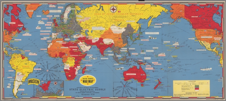
Author
Turner, Stanley
Full Title
Dated Events War Map. 1945. 17th Edition.
List No
15498.000
Author
[Fuller, R. Buckminster, Time Inc.]
Full Title
(6 Dymaxion Globe Gores)
List No
15437.004
Author
[Fuller, R. Buckminster, Time Inc.]
Full Title
(8 Dymaxion Globe Gores)
List No
15437.006
Author
[Fuller, R. Buckminster, Time Inc.]
Full Title
(Composite map of) North Pole Layout p.53; 14 Dymaxion Globe Gores
List No
15437.010
Author
[Fuller, R. Buckminster, Time Inc.]
Full Title
(Composite map of) Mercator World p.55; 14 Dymaxion Globe Gores
List No
15437.011
Author
[Fuller, R. Buckminster, Time Inc.]
Full Title
(Composite map of) Heartland p.55; 14 Dymaxion Globe Gores
List No
15437.012
Author
[Fuller, R. Buckminster, Time Inc.]
Full Title
(Composite map of) British Empire p.55; 14 Dymaxion Globe Gores
List No
15437.013
Author
[Fuller, R. Buckminster, Time Inc.]
Full Title
(Composite map of) Jap(anese) Empire p.55; 14 Dymaxion Globe Gores
List No
15437.014
Author
News Map of the Week, Inc.
Full Title
World News of the Week : Monday, Oct. 25, 1943. Covering period Oct. 15 to Oct. 21. Volume 6, No. 8. Published and copyrighted (weekly), 1943, by News Map of the Week, Inc., 1512 Orleans Street, Chicago, Illinois. Published in two sections : Section one. Lithographed in U. S. A.
List No
14141.000
Note
Lithographed world map, in color. Shows political boundaries and military events of World War II, from October 15 to 21, 1943. Relief illustrated with hachures. Descriptive text throughout, e.g.: Mikhailovitch's army moves toward Danube. Map indexed according to historical notes beneath map. Features photographs, illustrations, and international time zones. With diagram: Growth of the United States Navy. Map is 56 x 115 cm, on sheet 89 x 120 cm, folded to 31 x 23 cm.
Author
News Map of the Week, Inc.
Full Title
World News of the Week : Monday, Nov. 1, 1943. Covering period Oct. 22 to Oct. 28. Volume 6, No. 9. Published and copyrighted (weekly), 1943, by News Map of the Week, Inc., 1512 Orleans Street, Chicago, Illinois. Published in two sections : Section one. Lithographed in U. S. A.
List No
14142.000
Note
Lithographed world map, in color. Shows political boundaries and military events of World War II, from October 22 to 28, 1943. Relief illustrated with hachures. Descriptive text throughout, e.g.: Famine threatens Calcutta. Map indexed according to historical notes beneath map. Features photographs, illustrations, and international time zones. With diagram: Parachutes. Map is 56 x 115 cm, on sheet 89 x 120 cm, folded to 31 x 23 cm.
Author
News Map of the Week, Inc.
Full Title
World News of the Week : Monday, Nov. 8, 1943. Covering period Oct. 29 to Nov. 4. Volume 6, No. 10. Published and copyrighted (weekly), 1943, by News Map of the Week, Inc., 1512 Orleans Street, Chicago, Illinois. Published in two sections : Section one. Lithographed in U. S. A.
List No
14143.000
Note
Lithographed world map, in color. Shows political boundaries and military events of World War II, from October 29 to November 4, 1943. Relief illustrated with hachures. Includes a key indicating the alignment of warring nations (United, Axis, and neutral). Descriptive text throughout, e.g.: Nazis trapped in Crimea. Map indexed according to historical notes beneath map. Features photographs, illustrations, and international time zones. With diagram: What our big cities are spending on children's education. Map is 56 x 115 cm, on sheet 89 x 120 cm, folded to 31 x 23 cm.
|


![Covers: 圖勢現 [Statistical Charts]](https://www.davidrumsey.com/rumsey/Size2/RUMSEY~8~1/213/15877001.jpg)
![Text: 圖勢現 [Statistical Charts]](https://www.davidrumsey.com/rumsey/Size2/RUMSEY~8~1/213/15877002.jpg)
![(1) 圖勢現 [Statistical Charts]](https://www.davidrumsey.com/rumsey/Size2/RUMSEY~8~1/213/15877003.jpg)
![(2-3) 圖勢現 [Statistical Charts]](https://www.davidrumsey.com/rumsey/Size2/RUMSEY~8~1/213/15877004.jpg)
![(4-5) 圖勢現 [Statistical Charts]](https://www.davidrumsey.com/rumsey/Size2/RUMSEY~8~1/213/15877005.jpg)
![(6-7) 圖勢現 [Statistical Charts]](https://www.davidrumsey.com/rumsey/Size2/RUMSEY~8~1/213/15877006.jpg)
![(8-9) 圖勢現 [Statistical Charts]](https://www.davidrumsey.com/rumsey/Size2/RUMSEY~8~1/213/15877007.jpg)
![(10-11) 圖勢現 [Statistical Charts]](https://www.davidrumsey.com/rumsey/Size2/RUMSEY~8~1/213/15877008.jpg)
![(12-13) 圖勢現 [Statistical Charts]](https://www.davidrumsey.com/rumsey/Size2/RUMSEY~8~1/213/15877009.jpg)
![(14-15) 圖勢現 [Statistical Charts]](https://www.davidrumsey.com/rumsey/Size2/RUMSEY~8~1/213/15877010.jpg)
![(16-17) 圖勢現 [Statistical Charts]](https://www.davidrumsey.com/rumsey/Size2/RUMSEY~8~1/213/15877011.jpg)
![(18-19) 圖勢現 [Statistical Charts]](https://www.davidrumsey.com/rumsey/Size2/RUMSEY~8~1/213/15877012.jpg)
![(20-21) 圖勢現 [Statistical Charts]](https://www.davidrumsey.com/rumsey/Size2/RUMSEY~8~1/213/15877013.jpg)
![(22-23) 圖勢現 [Statistical Charts]](https://www.davidrumsey.com/rumsey/Size2/RUMSEY~8~1/213/15877014.jpg)
![(24-25) 圖勢現 [Statistical Charts]](https://www.davidrumsey.com/rumsey/Size2/RUMSEY~8~1/213/15877015.jpg)
![(26-27) 圖勢現 [Statistical Charts]](https://www.davidrumsey.com/rumsey/Size2/RUMSEY~8~1/213/15877016.jpg)
![(28-29) 圖勢現 [Statistical Charts]](https://www.davidrumsey.com/rumsey/Size2/RUMSEY~8~1/213/15877017.jpg)
![(30-31) 圖勢現 [Statistical Charts]](https://www.davidrumsey.com/rumsey/Size2/RUMSEY~8~1/213/15877018.jpg)
![(32-33) 圖勢現 [Statistical Charts]](https://www.davidrumsey.com/rumsey/Size2/RUMSEY~8~1/213/15877019.jpg)