|
Author
Mercier, Jacques
Full Title
Le Pacifique : Moitie De La Terre. Jac Mercier. Dessinateur.
List No
15803.001
Note
Date estimated from text.
Author
Mercier, Jacques
Full Title
L'Inde. Jac Mercier. Dessinateur.
List No
15804.001
Note
Date estimated from text.
Author
Mercier, Jacques
Full Title
U.R.S.S. (Jac Mercier. Dessinateur).
List No
15805.001
Note
Date estimated from text. Though not signed by Mercier, we assume he is the author.
Author
Mercier, Jacques
Full Title
Mer Mediterranie. (Jac Mercier. Dessinateur).
List No
15806.001
Note
Date estimated from text.
Author
[United States. Office of War Information, United States. Army. Western Defense Command, United States. Wartime Civil Control Administration]
Full Title
Net voluntary movement of Japanese : Western Defense Command Area, March 12th to June 5th, 1942. Western Defense Command and Fourth Army, Wartime Civil Control Administration.
List No
14375.033
Note
Map of the United States, featuring the allegedly voluntary migration of Japanese Americans in the Western Defense Command Area, from March 12th to June 5th, 1942. Shows political boundaries and utilizes data visualization to illustrate population density within the migration to different places. Includes a legend and explanatory note. Black and white. Map is 11 x 16 cm, on sheet 15 x 23 cm. Figure 11. Appears in Part IV : Evacuation - its operational technique, Chapter IX : Voluntary migration.
Author
[United States. Office of War Information, United States. Army. Western Defense Command, United States. Wartime Civil Control Administration]
Full Title
Japanese evacuation program : Exclusion areas. Western Defense Command and Fourth Army, Wartime Civil Control Administration, Statistical Division.
List No
14375.090
Note
Map of the western United States, featuring the "exclusion areas" for Japanese Americans during World War II. Shows political boundaries, assembly and relocation centers, bodies of water, coastline and islands. Includes a legend and explanatory note. With four inset maps: Seattle and vicinity -- Portland and vicinity -- San Francisco and vicinity -- Los Angeles and vicinity -- Sacramento and vicinity. In color. Map is 32 x 32 cm, on fold-out sheet 45 x 36 cm. Figure 27. Appears in Part VI : Relocation of evacuees, Chapter XXII : Transfer of evacuees from assembly to relocation centers.
Author
[United States. Office of War Information, United States. Army. Western Defense Command, United States. Wartime Civil Control Administration]
Full Title
Japanese evacuation program : Assembly center destinations. Western Defense Command and Fourth Army, Wartime Civil Control Administration, Statistical Division.
List No
14375.091
Note
Map of the western United States, featuring the assembly center destinations for Japanese Americans during World War II. Shows political boundaries, assembly and relocation centers, bodies of water, coastline and islands. Includes a legend and explanatory note. With five inset maps: Seattle and vicinity -- Portland and vicinity -- San Francisco and vicinity -- Los Angeles and vicinity -- Sacramento and vicinity. In color. Map is 32 x 32 cm, on fold-out sheet 45 x 36 cm. Figure 27. Appears in Part VI : Relocation of evacuees, Chapter XXII : Transfer of evacuees from assembly to relocation centers.
Author
[United States. Office of War Information, United States. Army. Western Defense Command, United States. Wartime Civil Control Administration]
Full Title
Japanese evacuation program : Relocation center destinations. Western Defense Command and Fourth Army, Wartime Civil Control Administration, Statistical Division.
List No
14375.092
Note
Map of the western United States, featuring the relocation center destinations for Japanese Americans during World War II. Shows political boundaries, assembly and relocation centers, bodies of water, coastline and islands. Includes a legend and explanatory note. With five inset maps: Seattle and vicinity -- Portland and vicinity -- San Francisco and vicinity -- Los Angeles and vicinity -- Sacramento and vicinity. In color. Map is 32 x 32 cm, on fold-out sheet 45 x 36 cm. Figure 27. Appears in Part VI : Relocation of evacuees, Chapter XXII : Transfer of evacuees from assembly to relocation centers.
Author
[United States. Office of War Information, United States. Army. Western Defense Command, United States. Wartime Civil Control Administration]
Full Title
Japanese population, assembly and relocation centers : Western Defense Command Area : June 7, 1942. Western Defense Command and Fourth Army, Wartime Civil Control Administration, Statistical Division.
List No
14375.101
Note
Map featuring the Japanese American population at assembly and relocation centers in the Western Defense Command Area, as of June 7, 1942. Shows political boundaries, bodies of water, drainage, coastline and islands. Includes a legend. Map is 16 x 12 cm, on sheet 23 x 15 cm. Figure 36. Appears in Part VIII : Statistical and fiscal summary, Chapter XXVIII : Statistical summary.
Author
Aspioti-ELKA (Firm)
Full Title
EXΘPIKH KATOXH-ΔIAMEΛIΣMOΣ THΣ XΩPAΣ : ΠPΩTH ΠEPIOΔOΣ 1941-1942.
List No
14295.039
Note
Colored map of Greece, showing the Italian, German and Bulgarian Occupation of Greece from 1943 to 1944. Delineates between the areas occupied by the Italians, Germans and Bulgarian. First in a series of four maps that represent military activity in Greece from 1941 to 1944. With national flags indicating boundaries. Also shows international political borders, cities, coastlines and islands. Includes a scale statement and an indexed legend, which the descriptive text on facing page explains. Accompanying text appears in Greek, French, English and Russian, entitled, Second phase of the Occupation. Description begins: At once the axis forces divided Greece into many zones and allocated them to the Germans, the Italians and the Bulgarians, who fell on the corpse of Greece in order to secure their reward for the assistance they gave to the Germans ... Map is 39 x 31 cm, on sheet 47 x 35 cm. (Plate number 15, according to descriptive text.) Within the second section of the atlas, Greece at war.
Author
Aspioti-ELKA (Firm)
Full Title
ΔIAMEΛIΣMOΣ THΣ XΩPAΣ KATA THN KATOXH : KAI OIKONOMIKH AΠOMONΩΣH TΩN ΔIAΦOPΩN ΠEPIOXΩN THΣ.
List No
14295.041
Note
Colored map of Greece, showing the dismemberment of Greece, circa 1942. Delineates between economic barriers, Bulgarian annexation, Italian occupation and Italian annexation. Second in a series of four maps that represent military activity in Greece from 1941 to 1944. Also shows international political borders, cities, coastlines and islands. Includes a scale statement and an indexed legend, which the descriptive text on facing page explains. Accompanying text appears in Greek, French, English and Russian, entitled, The dismemberment of the country. Description begins: With the division of the country into zones of Occupation the Axis divided Greece into small states ... Map is 39 x 31 cm, on sheet 47 x 35 cm. (Date based upon previous map in series.) (Plate number 16, according to descriptive text.) Within the second section of the atlas, Greece at war.
Author
Generalstab Des Heeres, Abteilung Für Kreigskarten Und Vermessungswesen (General Staff of the Army, Department for District Maps and Surveying
Full Title
Stadtplan von Stalingrad.
List No
10842.001
Author
Generalstab Des Heeres, Abteilung Für Kreigskarten Und Vermessungswesen (General Staff of the Army, Department for District Maps and Surveying
Full Title
Mil-Geo-Karte of Stalingrad
List No
10842.002
Author
[Furushima, Matsunosuke, Hashimoto, Motome]
Full Title
古嶋松之助. Attack on Pearl Harbor. ハワイ大海戦図. [Hawai daikaisenzu].
List No
10806.000
Note
大日本雄辯會講談社. [Dai Nihon Yūbenkai Kōdansha]. Showa 17. 1942.
Author
News Map of the Week, Inc.
Full Title
World News of the Week : Monday, May 4, 1942. Covering period Apr. 24 to 30. Volume 4, No. 35. Published and copyrighted (weekly), 1942, by News Map of the Week, Inc., 1512 Orleans Street, Chicago, Illinois. Published in two sections : Section one. Lithographed in U. S. A.
List No
14097.000
Note
Lithographed world map, in color. Shows political boundaries and military events of World War II, from April 24 to 30, 1942. Relief illustrated with hachures. Includes a legend indicating control by the Free French and Vichy France. Descriptive text throughout, e.g.: Area subject to semi-blackout. Map indexed according to historical notes beneath map. Features photographs, illustrations, and international time zones. With inset map: The War moves northward with the sun. Also, with diagram: Factory wages; Food prices; Income taxes; Installment buying. Map is 56 x 115 cm, on sheet 89 x 120 cm, folded to 31 x 23 cm.
Author
News Map of the Week, Inc.
Full Title
World News of the Week : Monday, May 11, 1942. Covering period May 1 to 7. Volume 4, No. 36. Published and copyrighted (weekly), 1942, by News Map of the Week, Inc., 1512 Orleans Street, Chicago, Illinois. Published in two sections : Section one. Lithographed in U. S. A.
List No
14098.000
Note
Lithographed world map, in color. Shows political boundaries and military events of World War II, from May 1 to 7, 1942. Relief illustrated with hachures. Descriptive text throughout, e.g.: Where Japanese warship concentration is reported. Map indexed according to historical notes beneath map. Features photographs, illustrations, and international time zones. With eight inset maps: The Japanese Empire, Manchukuo to Corregidor : Japan, 1930 -- Japan, 1932 -- Japan, before Pearl Harbor -- Japan, Dec. 7 - Jan. 7, 1942 -- Japan, Jan. 7 - Feb. 7, 1942 -- Japan, Feb. 7 - Mar. 7, 1942 -- Japan, Mar. 7 - Apr. 7, 1942 -- Japan, April 7 to present. Map is 56 x 115 cm, on sheet 89 x 120 cm, folded to 31 x 23 cm.
Author
News Map of the Week, Inc.
Full Title
World News of the Week : Monday, May 25, 1942. Covering period May 15 to 21. Volume 4, No. 38. Published and copyrighted (weekly), 1942, by News Map of the Week, Inc., 1512 Orleans Street, Chicago, Illinois. Published in two sections : Section one. Lithographed in U. S. A.
List No
14100.000
Note
Lithographed world map, in color. Shows political boundaries and military events of World War II, from May 15 to 21, 1942. Relief illustrated with hachures. Includes a legend indicating Japanese political sovereignty. Descriptive text throughout, e.g.: Where British, French clash occurred. Map indexed according to historical notes beneath map. Features photographs, illustrations, and international time zones. With four inset maps: Principal oil fields and pipelines of the U. S. -- Martinique -- Guadeloupe -- Dakar. Map is 56 x 115 cm, on sheet 89 x 120 cm, folded to 31 x 23 cm.
Author
News Map of the Week, Inc.
Full Title
World News of the Week : Monday, June 1, 1942. Covering period May 22 to 28. Volume 4, No. 39. Published and copyrighted (weekly), 1942, by News Map of the Week, Inc., 1512 Orleans Street, Chicago, Illinois. Published in two sections : Section one. Lithographed in U. S. A.
List No
14101.000
Note
Lithographed world map, in color. Shows political boundaries and military events of World War II, from May 22 to 28, 1942. Relief illustrated with hachures. Includes a legend indicating the sale of defense bonds in the United States. Descriptive text throughout, e.g.: Territory coveted by Italy. Map indexed according to historical notes beneath map. Features photographs, illustrations, and international time zones. With two inset maps: (Asia) -- (Russia). Also, with diagram: Planes; Tanks; Guns; Ships. Map is 56 x 115 cm, on sheet 89 x 120 cm, folded to 31 x 23 cm.
Author
News Map of the Week, Inc.
Full Title
World News of the Week : Monday, June 8, 1942. Covering period May 29 to June 4. Volume 4, No. 40. Published and copyrighted (weekly), 1942, by News Map of the Week, Inc., 1512 Orleans Street, Chicago, Illinois. Published in two sections : Section one. Lithographed in U. S. A.
List No
14102.000
Note
Lithographed world map, in color. Shows political boundaries and military events of World War II, from May 29 to June 4, 1942. Relief illustrated with hachures. Includes a legend indicating U. S. and Japanese bases, as well as bombings by Japan. Descriptive text throughout, e.g.: Chinese advance here. Map indexed according to historical notes beneath map. Features photographs, illustrations, and international time zones. With two inset maps: (Libya and Egypt) -- (Crucial battleground). Also, with diagram: Per capita income in the United States. Map is 56 x 115 cm, on sheet 89 x 120 cm, folded to 31 x 23 cm.
Author
News Map of the Week, Inc.
Full Title
World News of the Week : Monday, Sept. 7, 1942. Covering period Aug. 28 to Sept. 3. Volume 5, No. 1. Published and copyrighted (weekly), 1942, by News Map of the Week, Inc., 1512 Orleans Street, Chicago, Illinois. Published in two sections : Section one. Lithographed in U. S. A.
List No
14103.000
Note
Lithographed world map, in color. Shows political boundaries and military events of World War II, from August 28 to September 3, 1942. Relief illustrated with hachures. Descriptive text throughout, e.g.: Area Reds had retaken. Map indexed according to historical notes beneath map. Features photographs, illustrations, and international time zones. With two inset maps: Islands of the Pacific pinpoint battlefronts -- The world after three years of ever-widening war. Also, with pictures of aircraft symbols. Map is 56 x 115 cm, on sheet 89 x 120 cm, folded to 31 x 23 cm.
Author
News Map of the Week, Inc.
Full Title
World News of the Week : Monday, Sept. 14, 1942. Covering period Sept. 4 to Sept. 10. Volume 5, No. 2. Published and copyrighted (weekly), 1942, by News Map of the Week, Inc., 1512 Orleans Street, Chicago, Illinois. Published in two sections : Section one. Lithographed in U. S. A.
List No
14104.000
Note
Lithographed world map, in color. Shows political boundaries and military events of World War II, from September 4 to 10, 1942. Relief illustrated with hachures. Descriptive text throughout, e.g.: Allies complete vital railroad. Map indexed according to historical notes beneath map. Features photographs, illustrations, and international time zones. With six inset maps: How warring Germany has changed the face of Europe : 1914 -- 1919 -- 1939, Mar. 22 -- 1940, Sept. 1 -- 1941, Sept. 1 -- 1942, Sept. 1. Map is 56 x 115 cm, on sheet 89 x 120 cm, folded to 31 x 23 cm.
Author
News Map of the Week, Inc.
Full Title
World News of the Week : Monday, Sept. 21, 1942. Covering period Sept. 11 to Sept. 17. Volume 5, No. 3. Published and copyrighted (weekly), 1942, by News Map of the Week, Inc., 1512 Orleans Street, Chicago, Illinois. Published in two sections : Section one. Lithographed in U. S. A.
List No
14105.000
Note
Lithographed world map, in color. Shows political boundaries and military events of World War II, from September 11 to 17, 1942. Relief illustrated with hachures. Descriptive text throughout, e.g.: Area effected by fuel ration order. Map indexed according to historical notes beneath map. Features photographs, illustrations, and international time zones. With two inset maps: (Madagascar) -- The gates of Stalingrad. Also, with diagram: Ships; Tires; Steel. Map is 56 x 115 cm, on sheet 89 x 120 cm, folded to 31 x 23 cm.
Author
News Map of the Week, Inc.
Full Title
World News of the Week : Monday, Oct. 19, 1942. Covering period Oct. 9 to Oct. 15. Volume 5, No. 7. Published and copyrighted (weekly), 1942, by News Map of the Week, Inc., 1512 Orleans Street, Chicago, Illinois. Published in two sections : Section one. Lithographed in U. S. A.
List No
14107.000
Note
Lithographed world map, in color. Shows political boundaries and military events of World War II, from October 9 to 15, 1942. Relief illustrated with hachures. Descriptive text throughout, e.g.: Reds supply city during night by boat. Map indexed according to historical notes beneath map. Features photographs, illustrations, and international time zones. With diagram: Accidents increase; Time lost is costly; Steps in a safety campaign. Map is 56 x 115 cm, on sheet 89 x 120 cm, folded to 31 x 23 cm.
Author
News Map of the Week, Inc.
Full Title
World News of the Week : Monday, Oct. 26, 1942. Covering period Oct. 16 to Oct. 22. Volume 5, No. 8. Published and copyrighted (weekly), 1942, by News Map of the Week, Inc., 1512 Orleans Street, Chicago, Illinois. Published in two sections : Section one. Lithographed in U. S. A.
List No
14108.000
Note
Lithographed world map, in color. Shows political boundaries and military events of World War II, from October 16 to 22, 1942. Relief illustrated with hachures. Descriptive text throughout, e.g.: Italians fortify Dalmation coast. Map indexed according to historical notes beneath map. Features photographs, illustrations, and international time zones. With inset map: Guadalcanal : Cockpit of the Southwest Pacific. Also, with diagram: World gold production. Map is 56 x 115 cm, on sheet 89 x 120 cm, folded to 31 x 23 cm.
Author
Harrison, Richard Edes
Full Title
The physical world to the west. Richard Edes Harrison. Supplement to Fortune, January 1942, Copr. 1941 Time Inc.
List No
13491.001
Author
News Map of the Week, Inc.
Full Title
World News of the Week : Monday, Jan. 12, 1942. Covering period Jan. 2 to Jan. 8. Volume 4, No. 19. Published and copyrighted (weekly), 1942, by News Map of the Week, Inc., 1512 Orleans Street, Chicago, Illinois. Published in two sections : Section one. Lithographed in U. S. A.
List No
14084.000
Note
Lithographed world map, in color. Shows political boundaries and military events of World War II, from January 2 to 8, 1942. Relief illustrated with hachures. Descriptive text throughout, e.g.: British take total of 7,000 prisoners here. Map indexed according to historical notes beneath map. Features photographs, illustrations, and international time zones. With four inset maps: The fortress of Corregidor Island -- (Br. Malaya) -- Where U. S. trains troops for war -- Highlights of the War in 1941. Also, with diagram: U. S. donations for war relief. Map is 56 x 115 cm, on sheet 89 x 120 cm, folded to 31 x 23 cm.
Author
News Map of the Week, Inc.
Full Title
World News of the Week : Monday, Jan. 19, 1942. Covering period Jan. 9 to Jan. 15. Volume 4, No. 20. Published and copyrighted (weekly), 1942, by News Map of the Week, Inc., 1512 Orleans Street, Chicago, Illinois. Published in two sections : Section one. Lithographed in U. S. A.
List No
14085.000
Note
Lithographed world map, in color. Shows political boundaries and military events of World War II, from January 9 to 15, 1942. Relief illustrated with hachures. Descriptive text throughout, e.g.: Australian Navy Minister says U. S. British reinforcements on way east. Map indexed according to historical notes beneath map. Features photographs, illustrations, and international time zones. With two inset maps: Enemy's industries -- (Manila Bay). Also, with three diagrams: Japanese naval losses in the Far East -- 1943 Budget; U. S. Budget; Defense; Public Debt -- U. S. Army Strength. Map is 56 x 115 cm, on sheet 89 x 120 cm, folded to 31 x 23 cm.
Author
News Map of the Week, Inc.
Full Title
World News of the Week : Monday, Jan. 26, 1942. Covering period Jan. 16 to Jan. 22. Volume 4, No. 21. Published and copyrighted (weekly), 1942, by News Map of the Week, Inc., 1512 Orleans Street, Chicago, Illinois. Published in two sections : Section one. Lithographed in U. S. A.
List No
14086.000
Note
Lithographed world map, in color. Shows political boundaries and military events of World War II, from January 16 to 22, 1942. Relief illustrated with hachures. Descriptive text throughout, e.g.: Dutch Islands being guarded by U. S. Air Force. Map indexed according to historical notes beneath map. Features photographs, illustrations, and international time zones. With two inset maps: Malay States -- When the Allies attack Japan. Also, with diagram: Average hourly wage rates in manufacturing industry. Map is 56 x 115 cm, on sheet 89 x 120 cm, folded to 31 x 23 cm.
Author
Mercier, Jacques
Full Title
Le front de l'Ocean. Jac Mercier. dessinateur.
List No
13400.000
Note
Dated 31-3-42
Author
Burke, Howard
Full Title
Los Angeles Examiner. Tuesday, September 29, 1942 : Tokyo's Next Bombing May Come From Vladivostok. Howard Burke.
List No
13178.000
Note
Color map from the Los Angeles Examiner Pictorial Review section, Sept. 29, 1942. Illustrated by Howard Burke. With 2 inset maps: Manchukuo and Soviet Russia. Shows battle fields, naval and air force areas, roads and railroads. Includes informative text and overview of the geopolitical situation of the area.
Author
Herald American
Full Title
Pictorial Review. Herald American, Sec. IV- Sunday August 1942. New World Map Shows Vital Importance of Alaska -- (See Page 2). This is a reduced copy of the polar (Casson) Projection Map of the World ... Copyright by the Universal Map Co., Inc. New York, N.Y.
List No
13180.000
Note
Color map from Herald American Pictorial Review August 1942. with 6 insets. The polar projection of this map effectively shows the proximity of Alaska and the Asian theater of war. " The Second World War saw a revival in popular interest in geography and maps; this interest was further fueled by the new "aviation era" maps produced by mapmakers such as Richard Edes Harrison, and their inclusion in newspapers around the States.
Author
Anonymous
Full Title
(Current status of U.S. Navy in the Pacific War.)
List No
13104.000
Note
Color map in Japanese, with 2 insets legend and notes. Date estimated. Showing the areas of the conflict, war planes, battle ships and distances.
Author
Anonymous
Full Title
Despues de tres anos de victorias Septiembre 1939 - Septiembre 1942. WPr / IV. E - Nr. 24-IX / 1942-Er.
List No
11808.000
Note
German propaganda map of the world in Spanish, celebrating the German and Japanese success in World War II from September 1939 to September 1942 after 3 victorious years and their role as the Liberators of the new young vibrant peoples of Europe and Asia. The map illustrates the dual assaults of Germany and Japan in the eastern and western theaters. Includes 2 insets, explanatory text and legend describing the conventional signs.
Author
Chapin, Jr., R.M.
Full Title
African battlegrounds. TIME map by R.M. Chapin, Jr. For report documenting above map see Time, October 12, 1942 issue.
List No
11772.000
Note
Color map of North Africa. "Enlargement of original map drawn for TIME The weekly magazine.". R.M. Chapin Jr. was a prominent Cold War cartographer who worked for Time Magazine. Includes legend. Relief shown by shading.
Author
Chapin, Jr., R.M.
Full Title
Algeria. TIME map by R.M. Chapin, Jr. For report documenting above map see Time, November 23, 1942 issue.
List No
11773.000
Note
Color map. "Enlargement of original map drawn for TIME The weekly magazine.". R.M. Chapin Jr. was a prominent Cold War cartographer who worked for Time Magazine. Relief shown by shading.
Author
Sundberg, Edwin L.
Full Title
World at War. January 25, 1942.
List No
12257.000
Author
Sundberg, Edwin L.
Full Title
Oil, the Target of the Axis. July 26, 1942.
List No
12259.000
Author
SPK
Full Title
Confiance ... ses Amputations se Poursuivent Methodiquement (Be reassured, the amputations (of his tentacles) are proceeding methodically).
List No
9750.000
Author
Chase, Ernest Dudley, 1878-1966
Full Title
Japan, the target : a pictorial Jap-map : By Ernest Dudley Chase of Winchester, Mass. Published and copyright, Ernest Dudley Chase, Winchester, Mass. Printed in U.S.A.
List No
8056.000
Note
World War II pictorial battle map of Japan. With numerous legends noting boundaries, cities, population, rivers, naval bases, and list of aircrafts. Shows fighter planes, the distances between locations in the U.S., such as San Francisco to Manila. Relief shown pictorially. Includes note on Manchuria.
Author
Burke, Howard
Full Title
The Pacific - Vital area for United States and Japan. Los Angels Examiner ... November 1942. Howard Burke. (inset) Palau Islands.
List No
8066.000
Note
Color pictorial map, mounted on Japanese paper. With inset at lower right corner. Showing Greater East Asia and Pacific Islands with air and naval Bases. Text box at lower left note" The war in the Pacific opened with the sneak attack on Pearl Harbor ...". Relief shown pictorially. Informative text labels and small pictographs provide an effective overview of the geopolitical situation, in keeping with the "air-age" .
Author
Turner, Stanley
Full Title
Dated events, World War map, by Stanley Turner A.R.C.A. Printed in Canada by R.G. McLean Limited, Toronto. Copyright C.C. Petersen Advertising, 57 Qeen St. West, Toronto. Second edition. Price 25 cents. (insets) Western hemisphere. Part of the Eastern hemisphere. Africa.
List No
6827.000
Note
2nd. edition, World War Map in full color. Legend includes naval bases; cities blitzed by Nazis Luftwaffe; industries bombed by R.A.F; countries under British control; countries conquered by the Nazis; neutral countries. Relief shown pictorially. Note: "This map illustrates the important events since the War began September 3, 1939 ... " From the collection of John Oram.
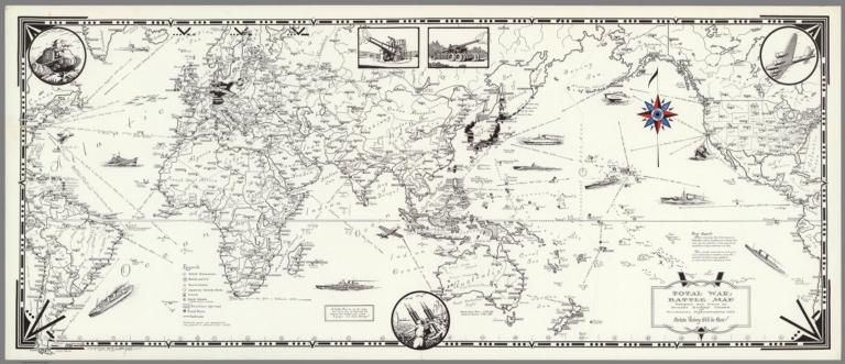
Author
Chase, Ernest Dudley, 1878-1966
Full Title
Total War, Battle Map. Designed and Drawn by Ernest Dudley Chase of Winchester, Massachusetts, U.S.A. Certain Victory Will be Ours.
List No
10035.000
Note
Uncolored version - see also our 8527.000, 8702.000, and 8531.000 for variants. and Shows Allied and Axis holdings. Illustrated with weapons. This copy differs from our other copy, 8527.000, by not having any text on the verso. It is also signed by Chase.
Author
Hagstrom Company
Full Title
Hagstrom's Map of the Aleutian Islands, Alaska. Hagstrom's Map of Europe, Mediterranean and North Africa. Hagstrom's Map of the Southwest Pacific.
List No
10041.002
Note
Differs from the other similar 1942 by having an ad for Facsimile machine.
Author
Hagstrom Company
Full Title
Hagstrom's Map of the World.
List No
10041.003
Note
Differs from the other similar 1942 by having an ad for Facsimile machine.
Author
[Turner, Stanley, Petersen, C.C.]
Full Title
Dated events war map of the Pacific and Far East. Second edition. Stanley Turner. Printed in Canada by R.G. McLean, Toronto. Copyright U.S.A. and Canada, C.C. Petersen Advertising.
List No
10407.000
Author
[Owens, Charles H., Los Angeles Times]
Full Title
Here's history of war since America entered the conflict year ago. By Charles Owens, Los Angeles Times. December 7, 1942.
List No
11003.000
Note
Color pictorial map, packed with information on timeline history of war since America entered the conflict, 1942. Date from verso. Shows political alignment, military bases, Pearl Harbor at the center of map, etc.
Author
[Los Angeles Times, Owens, Charles H.]
Full Title
Nazis are far from taking the real prize of Causasus, Baku. By Charles Owens, Los Angeles Times. Monday morning. Los Angeles times. September 28, 1942 - (Part L).
List No
11016.000
Note
Color map. Shows boundaries, major cities, rail roads, oil fields, oil pipelines, rivers, etc. Includes historical notes and text. Relief shown pictorially and by spot heights.
Author
[Los Angeles Times, Owens, Charles H.]
Full Title
North African area where British, American battle Axis forces. By Charles Owens, Los Angeles Times. Los Angeles Times Monday morning, December 14, 1942.
List No
11020.000
Note
Color map, with detailed view of land, sea and air confrontations at upper panel. Shows Allied transport and supply routes, lines of air attack by allied from Malta, major cities, rail roads, rivers, canals, etc. Relief shown pictorially. Includes historical notes and text "This map indicates the geueral (general) area of the past month's activities, and points out possible regions of new conflict."
Author
[Los Angeles Times, Owens, Charles H.]
Full Title
Italy, boot of the Mediterranean, may prove Achilles Heel of Axis. By Charles Owens, Los Angeles Times. Los Angeles Times Monday morning, November 2, 1942.
List No
11021.000
Note
Color map. Shows convoy routes, lines of air attack by allied from Malta, distances, bases, major cities, rail roads, forts, etc. Relief shown pictorially. Includes historical notes and text.
Author
[Los Angeles Times, Owens, Charles H.]
Full Title
What are the possibilities of attacking the Islands of Japan. Map by Charles Owens, Times Staff Artist. Los Angeles Times Monday morning, May 4, 1942.
List No
11022.000
Note
Color map. Shows lines of air attack to Japan, distances, bases, major cities, population, rail roads, etc. Relief shown pictorially. Includes historical notes and text: "This map, in line and legend, pictures possibilities of invasion by way of China and Korea, by way of Russia and briefly, from the north by way of Alaska ..."
|


![15. EXΘPIKH KATOXH-ΔIAMEΛIΣMOΣ THΣ XΩPAΣ ...[The first phase of Occupation].](https://www.davidrumsey.com/rumsey/Size1/RUMSEY~8~1/195/14295039.jpg)
![16. ΔIAMEΛIΣMOΣ THΣ XΩPAΣ KATA THN KATOXH ...[The dismemberment of the country].](https://www.davidrumsey.com/rumsey/Size2/RUMSEY~8~1/195/14295041.jpg)


![古嶋松之助. Attack on Pearl Harbor. ハワイ大海戦図. [Hawai daikaisenzu].](https://www.davidrumsey.com/rumsey/Size2/RUMSEY~8~1/190/10806000.jpg)